
Dangerous heat will expand from the Gulf Coast into the Southern Plains and Desert Southwest through week's end. Additional extreme heat impacting the Pacific Northwest will shift to the northern Plains by the weekend. Tropical Storm Bertha is expected to continue to impact portions of the northern Gulf Coast from the western Florida Panhandle to southeastern Louisiana through tonight. Read More >
 |
** PLEASE NOTE...as of Oct. 30th:
- NWS Hastings has DISCONTINUED FROST ADVISORIES/FREEZE WARNINGS this fall for ALL 30 COUNTIES in our forecast area. Nearly all areas dropped into the 20s on the morning of Oct. 30th, and all areas are now well past their average first fall freeze dates.
According to long-term averages, the entire NWS Hastings forecast area of central/south central NE and north central KS is now BEYOND THE 2-WEEK PERIOD THAT FEATURES THE AVERAGE DATE OF THE FIRST HARD/KILLING FREEZE OF THE FALL. Of course, as outlined extensively in the data presented below, the first fall frost/freeze dates can vary tremendously from one year to the next, and just within the past 30 years, "first freezes" (32°-or-colder) have ranged anywhere from mid-September to early-mid November. Last fall (2024) actually featured fairly "normal" dates for the first official freeze (32°-or-colder) in most places, BUT the first "hard freeze" (28º-or-colder) was unusually-late (even record-late!) for many (see 2024 recap section below for more details)!
Please refer to the wealth of information within the tabs below (including tables/maps of average first frost/freeze/hard freeze dates) to stay on top of the frost/freeze situation across our local area this fall. Finally, check out the last tab for a glance back at the RECORD-EARLIEST frost/freeze that parts of our area experienced 51 years ago on Sept. 3, 1974!
Looking Ahead 7-10 Days: ** NOTE: Frost/Freeze Forecasts have been discontinued for Fall 2025 **
(updated Oct. 30...you can always check your official forecast at www.weather.gov/hastings for the latest)
Recapping Last Fall's (2024) First Frost/Freeze in the NWS Hastings coverage area:
Before continuing on, here are a few definitions...
| Frost Frost occurs when there is a solid deposition of water vapor from the air. Frost will form when solid surfaces are cooled below the dew point. An air temperature range of 33°- 36°, along with light winds, is usually needed to initiate frost formation. At least minor damage is possible to plants. One must keep in mind that a frost is not guaranteed if the air is very dry and/or winds are roughly 8+ MPH. The range of average dates for the FIRST FALL FROST across most of central/ Freeze Freeze occurs when the temperature drops to 32°-or-lower. A freeze will damage many unprotected plants, especially if the temperature remains at-or-below freezing for several hours. The range of average dates for the FIRST FALL FREEZE across most of Hard Freeze Hard freeze (per our local NWS definition) occurs when the temperature reaches 28°-or-lower. This usually means that most seasonal vegetation will be destroyed. In addition, there is the possibility for damage to unprotected outdoor plumbing/undrained sprinkler/irrigation systems etc. The range of average dates for the FIRST FALL HARD FREEZE across most of central/south central NE and north central KS is between Oct. 11 - 27 |
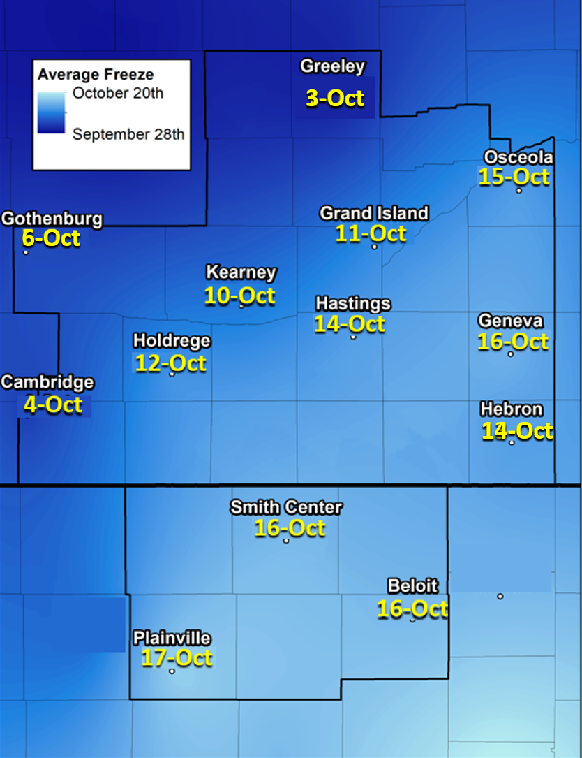
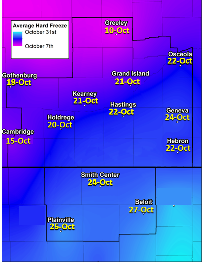
South Central Nebraska and North Central Kansas
30 Year Average First Frost/Freeze Dates (1994-2023)
(click image to enlarge)
 |
 |
 |
| Average First 36° Date (First Frost) |
Average First 32° Date (First Freeze) |
Average First 28° Date (First Hard Freeze) |
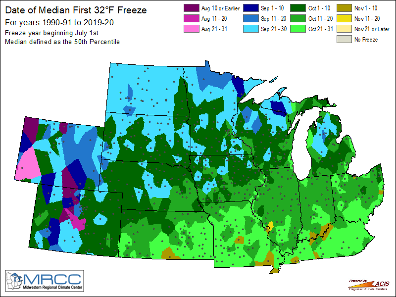
Median Dates of First Fall Freeze & Hard Freeze (1991-2020)
Images from the Midwestern Regional Climate Center
 |
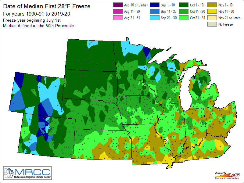 |
| Median Date of First 32° Freeze | Median Date of First 28° Hard Freeze |
Fall Frost/Freeze Data For Central/South Central Nebraska + North Central Kansas
(based on 30-year averages from 1995-2024)
| Avg. First Fall Date: 36° Or Colder 32° Or Colder 28° Or Colder |
1995-2024 Earliest First Date: 32° Or Colder |
1995-2024 Latest First Date: 32° Or Colder |
Last Year (2024) First Occurrence: 36° Or Colder 32° Or Colder 28° Or Colder |
|
| Greeley | Sept. 24 Oct. 2 Oct. 11 |
Sept. 19, 2003 | Oct. 17, 2021 | Sept. 23 (34º) Oct. 8 (32º) Oct. 14 (26º) |
| Osceola | Oct. 5 Oct. 16 Oct. 22 |
Sept. 22, 1995 | Nov. 14, 2024 (latest on record) |
Oct. 14 (35º) Nov. 14 (32º) Nov. 21 (28º) |
| Gothenburg | Oct. 1 Oct. 6 Oct. 20 |
Sept. 19, 2006 | Oct. 27, 2013 | Oct. 15 (31º) Oct. 15 (31º) Nov. 14 (27º) |
| Kearney Airport (NWS Observer) |
Oct. 2 Oct. 10 Oct. 21 |
Sept. 21, 1995 | Oct. 25, 1997 | Oct. 14 (31º) Oct. 14 (31º) Nov. 21 (26º) |
| Grand Island (airport) |
Oct. 3 Oct. 11 Oct. 22 |
Sept. 20, 1995 | Oct. 26, 2007 | Oct. 7 (36º) Oct. 14 (30º) Nov. 14 (28º) |
| Hastings (airport) |
Oct. 5 Oct. 14 Oct. 22 |
Sept. 21, 1995 | Nov. 3, 1998 | Oct. 14 (31º) Oct. 14 (31º) Nov. 21 (25º) |
| Holdrege | Oct. 4 Oct. 12 Oct. 20 |
Sept. 22, 1995 | Nov. 4, 1998 | Oct. 14 (30º) Oct. 14 (30º) Nov. 17 (26º) |
| Clay Center NE | Oct. 6 Oct. 16 Oct. 25 |
Sept. 22, 1995 | Nov. 4, 1998 | Oct. 14 (34º) Oct. 16 (31º) Oct. 17 (28º) |
| Cambridge | Sept. 27 Oct. 5 Oct. 15 |
Sept. 13, 2014 | Oct. 25, 1997 | Oct. 2 (36º) Oct. 14 (28º) Oct. 14 (28º) |
| Hebron | Oct. 4 Oct. 13 Oct. 22 |
Sept. 22, 1995 | Oct. 29, 2015 | Oct. 14 (30º) Oct. 14 (30º) Oct. 16 (27º) |
| Smith Center, KS | Oct. 8 Oct. 16 Oct. 24 |
Sept. 22, 1995 | Nov. 4, 1998 | not available not available not available |
| Plainville, KS | Oct. 8 Oct. 17 Oct. 25 |
Sept. 20, 1995 | Nov. 3, 1998 | Oct. 15 (36º) Oct. 16 (27º) Oct. 16 (27º) |
| Beloit, KS | Oct. 9 Oct. 16 Oct. 27 |
Sept. 13, 2014 | Nov. 10, 1998 | Oct. 14 (34º) Oct. 16 (26º) Oct. 16 (26º) |
* NOTE: 10 or fewer missing days of annual data allowed for averages
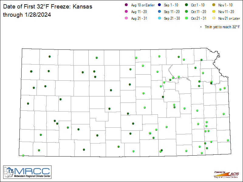
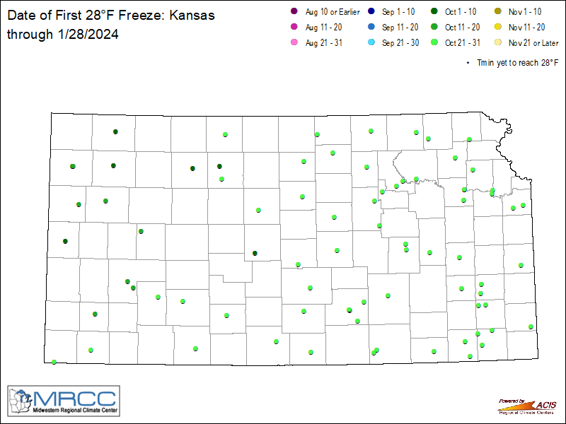
The Midwestern Regional Climate Center (MRCC) produces maps that update DAILY, depicting the first recorded dates that locations have dropped to at least 32°/28° so far this fall. Check out these statewide maps of Kansas and Nebraska by clicking on the images below.
 |
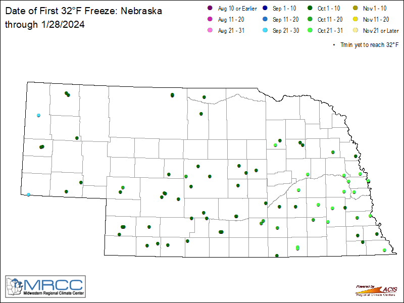 |
| KS Observed 32° or Below So Far This Fall | NE Observed 32° or Below So Far This Fall |
 |
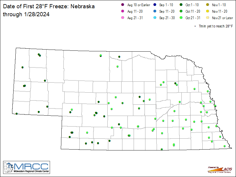 |
| KS Observed 28° or Below So Far This Fall | NE Observed 28° or Below So Far This Fall |
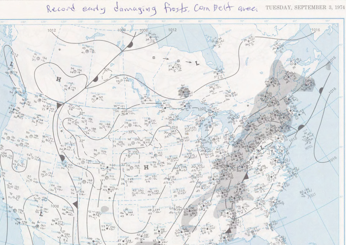
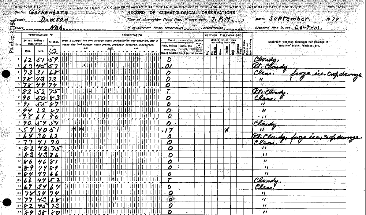
A Look Back At The Unusually Early Frost/Freeze Of September 1974:
One of the earliest frost and/or freezes on record in parts of central/south central NE and north central KS struck during the first week of September 1974, as many locations dropped below the freezing mark on Sept. 3rd! Just as a few examples: NWS cooperative observers in Beaver City/Ravenna reported morning lows as cold as 29º. Even in our KS coverage area, Webster Dam fell to 32º.
A surface weather map (below left) from Sept. 3, 1974 depicted just why such frigid temperatures were observed. An unseasonably cold airmass roared into the region behind a strong cold front. Eventually, surface high pressure set up over the region, creating an ideal situation for a record early freeze. In fact, note the handwritten comment "Record early damaging frosts, corn belt area" at the top of the weather map. The original NWS cooperative observation forms from Gothenburg and Greeley NE are also depicted below. The Gothenburg observer noted "Clear. Froze. Ice. Crop Damage" on the right side of the form on the 3rd. It's also interesting to note that both Gothenburg and Greeley recorded freezing temperatures again just 10 days later on Sept. 13!
 |
 |
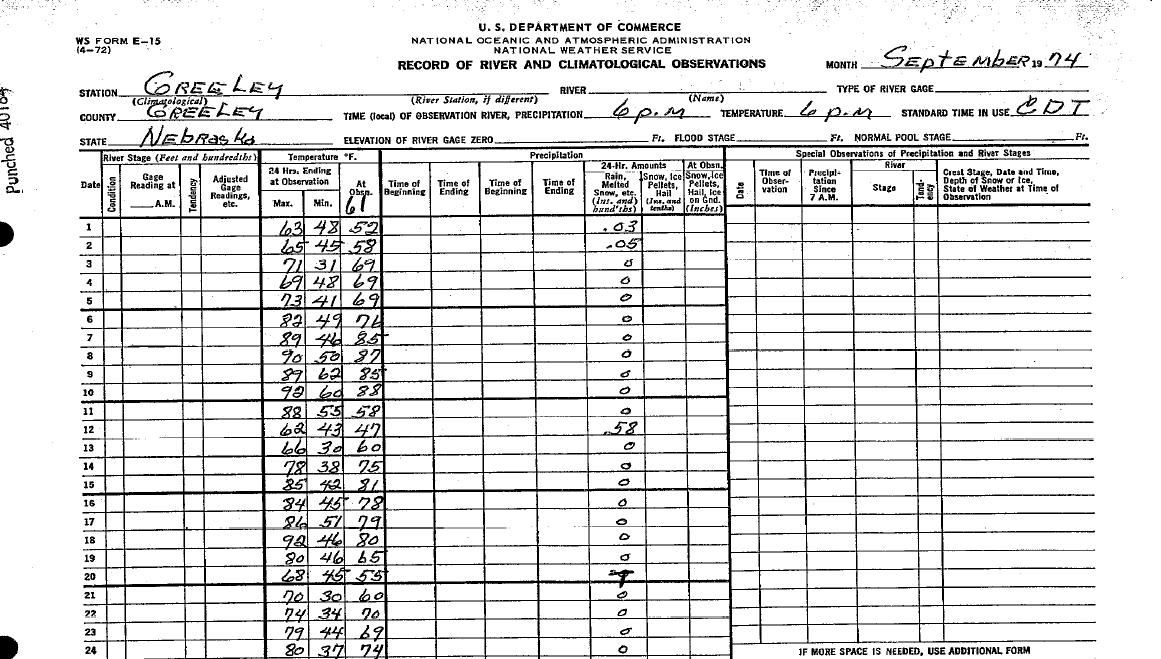 |
| Sep. 3, 1974 Weather Map | Gothenburg, NE Observation Form | Greeley, NE Observation Form |
For more Frost/Freeze related information including an interactive tool, check out the following source:
 |
Media use of NWS Web News Stories is encouraged! Please acknowledge the NWS as the source of any news information accessed from this site. |
|

