National Weather Service United States Department of Commerce

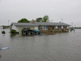
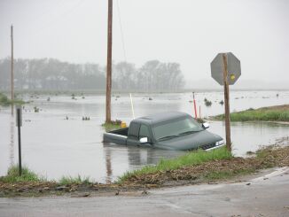
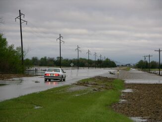
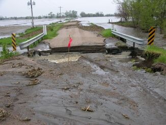
An area of low pressure developed in northwest Kansas on Wednesday, May 11, 2005.  A warm front extended to the northeast from the low into southern Nebraska.  An upper level disturbance along with a strong jet stream moved into the region in the afternoon.  The combination of these weather features allowed for very strong thunderstorms to develop in south-central Nebraska. 

The first storms developed in the Minden area around 3 pm and the storms quickly spread. One storm developed in northern Webster county to the south of Hastings and began to rotate. The storm continued to move to the northeast into the town of Hastings.  A few funnel clouds were reported with this storm, but the main problem was the 2 to 3 inch diameter hail that pounded the community.  There was widespread reported of damage to windows, siding, roofs, and vehicles in town.  With the storms holding over Adams county from 4 to 7 pm, copious amounts of rain fell.  Heavy rains continued into the night from eastern Dawson county York county with many areas picking up over 5 inches of rain. Unofficial reports from the Kenesaw and Wood River areas reported over 11 inches, nearly 10 inches around Grand Island, nearly 9 inches was reported on the around Hastings and 8 inches in the Central City area.  Flooding of roads and fields has been reported in these areas.

Access a map of the radar estimate of rainfall during the evening of May 11, 2005, click here

Below are a few pictures of the hail and flooding over the area, (click on any image to enlarge).

2005 May 11 Hastings Flooding Picture 1

Hastings flooding area is shown. Several cars became stranded in the community.

2005 May 11 Hastings Flooding Picture 2

Heavy rains in the Hastings area caused flooding of low lying areas and hail up to the size of baseballs also piled up.

2005 May 11 Hastings Flooding Picture 3

Hail and excess rainwater caused streets to flood in Hastings.

2005 May 11 Hastings Flooding Picture 4

A view of the underpass near downtown Hastings that filled from the heavy rains and hail that occurred.

2005 May 11 Wood_River Picture 1

A home near Wood River, NE that was surrounded by flooding caused by rainfalls in excess of 10 inches.

2005 May 11 Wood_River Picture 2

Flooding in Wood River is shown here. The streets in town quickly filled with water after thunderstorms dropped over 10 inches of rain.

2005 May 11 Wood_River Picture 3

Another home surrounded by water in the Wood River area.

2005 May 11 Wood_River Picture 4

Many fields and rural roads became flooded during the evening. We see a vehicle that got stranded in the flood waters in rural Hall county.

2005 May 11 North Channel Picture 1

A view of flood waters from the north channel of the Platte River south of Alda, NE.

2005 May 11 North Channel Picture 2

Flood waters caused some damage to the roadway and bridge along the north channel of the Platte River south of Alda, NE


Page created by WFO Hastings Staff on 5/12/2005.