
A significant heat wave continues for the Rockies, Northern Plains, and Great Lakes into the Mid-Atlantic, peaking in intensity through midweek and lingering across parts of the Northern Plains and Midwest until this weekend. Excessive rainfall my bring life-threatening and locally catastrophic flash and urban flooding across portions of southwestern Texas through early Friday. Read More >
If you have any photos you would like to share, please feel free to post them to our Facebook or Twitter pages, or send them to our webmaster e-mail account at: w-gid.webmaster@noaa.gov. Please let us know where the photo was taken, and at least an approximate time. Thanks!
November 16-17th, 2015: EF1 Tornado Touches Down In
Furnas County - Followed By Accumulating Snow
Radar Overview |
Tornado Information |
Precipitation Information |
Over a two day stretch of November 16-17, 2015, the NWS Hastings coverage area (Click HERE for a map) felt the effects of a strong upper level low pressure system which moved out of the Rockies and through the Central and Southern Plains. On the 16th, this system was responsible for severe weather (including confirmed tornadoes) stretching mainly from the northern half of Texas up into southern portions of Nebraska. Significant precipitation (especially by November standards) fell across the entire NWS Hastings area, with 48 hour totals (ending 8 a.m. Wed., Nov. 18th) exceeding 1 inch for most locations and a handful seeing 2-3" of liquid precipitation (rain/melted snow). As the system crossed the plains late on the 17th, enough cold air built in to result in a narrow band of accumulating snowfall, which extended from central Nebraska down into far northeastern portions of New Mexico.
 |
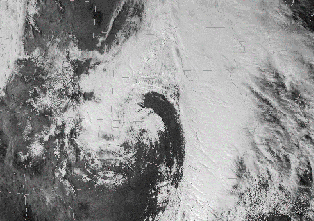 |
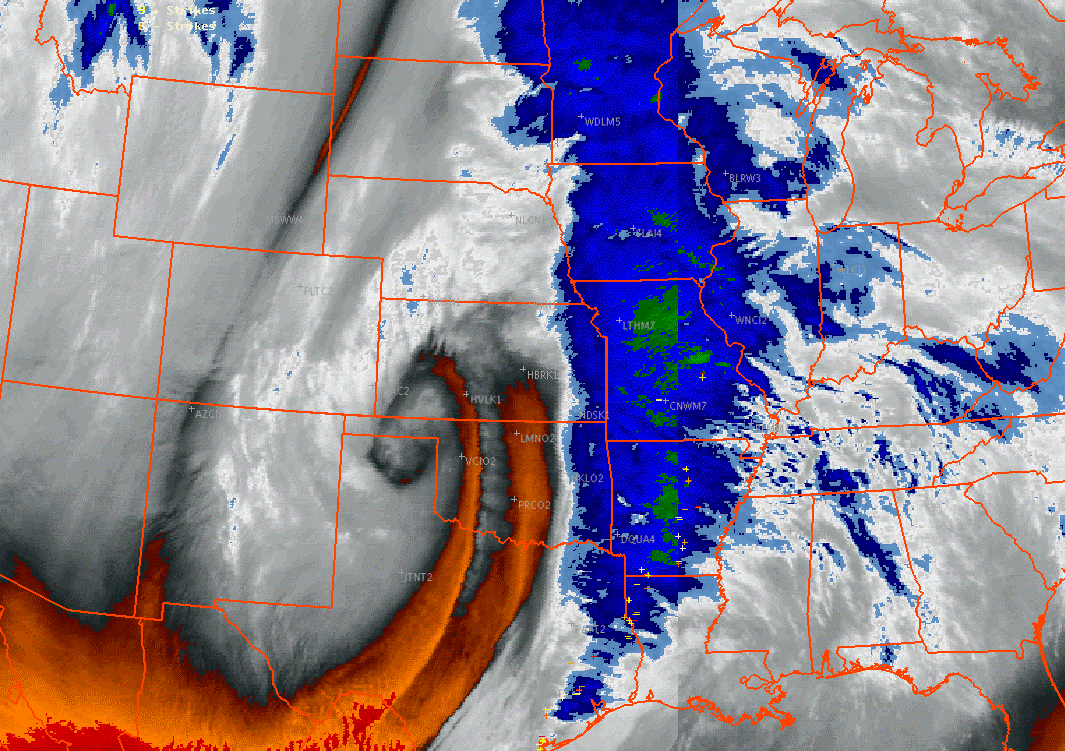
| Water vapor imagery from the morning of November 17th, showing the storm system moving through the Oklahoma/Texas panhandle area. | Visible satellite imagery from the afternoon of November 17th. Note the well defined dry slot (cloud free area) nosing into central Kansas. |
Radar Overview
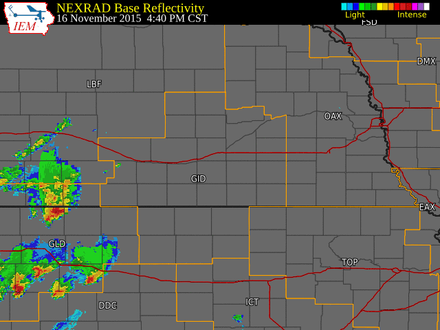
The NWS radar loop on the left runs from 4:40 p.m. November 16th to 7:25 p.m. CST November 17th, showing the period where strong to severe thunderstorms and the first round of rain occurred.
There was a bit of a lull before the next batch of precipitation expanded across the area, with the loop on the right showing this period, running from 8:55 a.m. November 17th to 10:25 a.m. CST November 18th. Rain started to mix in with and eventually turn over to all snow across roughly the western half of the coverage area late in the day of the 17th. More information about accumulations can be found below.
The NWS Hastings coverage area is located within the orange outlined area labeled "GID".
 |
.gif) |
Tornado Information & Storm Reports
Click on image below for more detailed information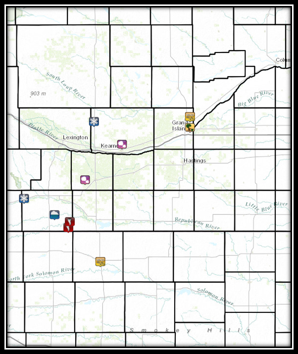 |
While there were a few reports from the strong to severe thunderstorms that developed, the main story is with the confirmed tornado that touched down in Furnas County in the Beaver City/Hollinger area.
For the NWS Hastings coverage area (click HERE for a map)...this was the first tornado reported in the month of November since an F0 tornado touched down southwest of Ayr (Adams County) on November 5th, 2000. In fact, until this event, that tornado near Ayr in 2000 had been the ONLY November tornado confirmed in our area since records started in 1950.
The radar loop below is one of storm relative velocity, showing the circulation of the the storm as it moved north from Norton County, KS into Furnas County, NE (please note that Norton County is covered by NWS Goodland KS). The red coloring indicates motion away from the NWS Hastings radar located near Blue Hill, NE, with green indicating motion toward the radar. Note toward the end of the loop, a second circulation develops to the southeast of the main one. There were no reports of a second tornado touchdown or indications of any damage. Click on the image for a larger version.
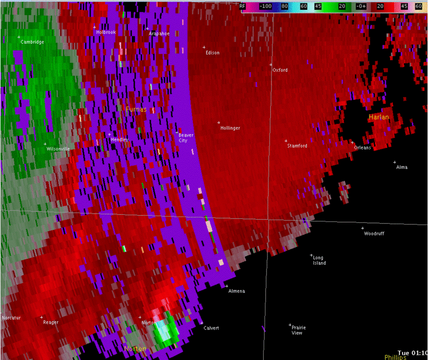 |
| Loop from 7:10-8:07 p.m. CST on Nov. 16th |
Tornado #1: 10.7 miles southeast to 8.2 miles northeast of Beaver City, NE (Furnas County)
Rating: EF-1
Estimated Peak Wind Speed: 95 MPH
Time: 7:31 to 7:57 p.m. CST
Path Length: 12.75 miles
Max Path Width: 400 yards (not the entire path)
Fatalities/Injuries: 0 / 0
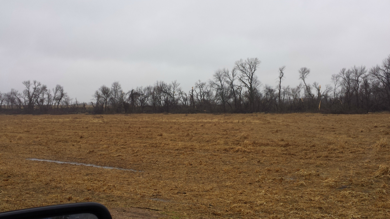
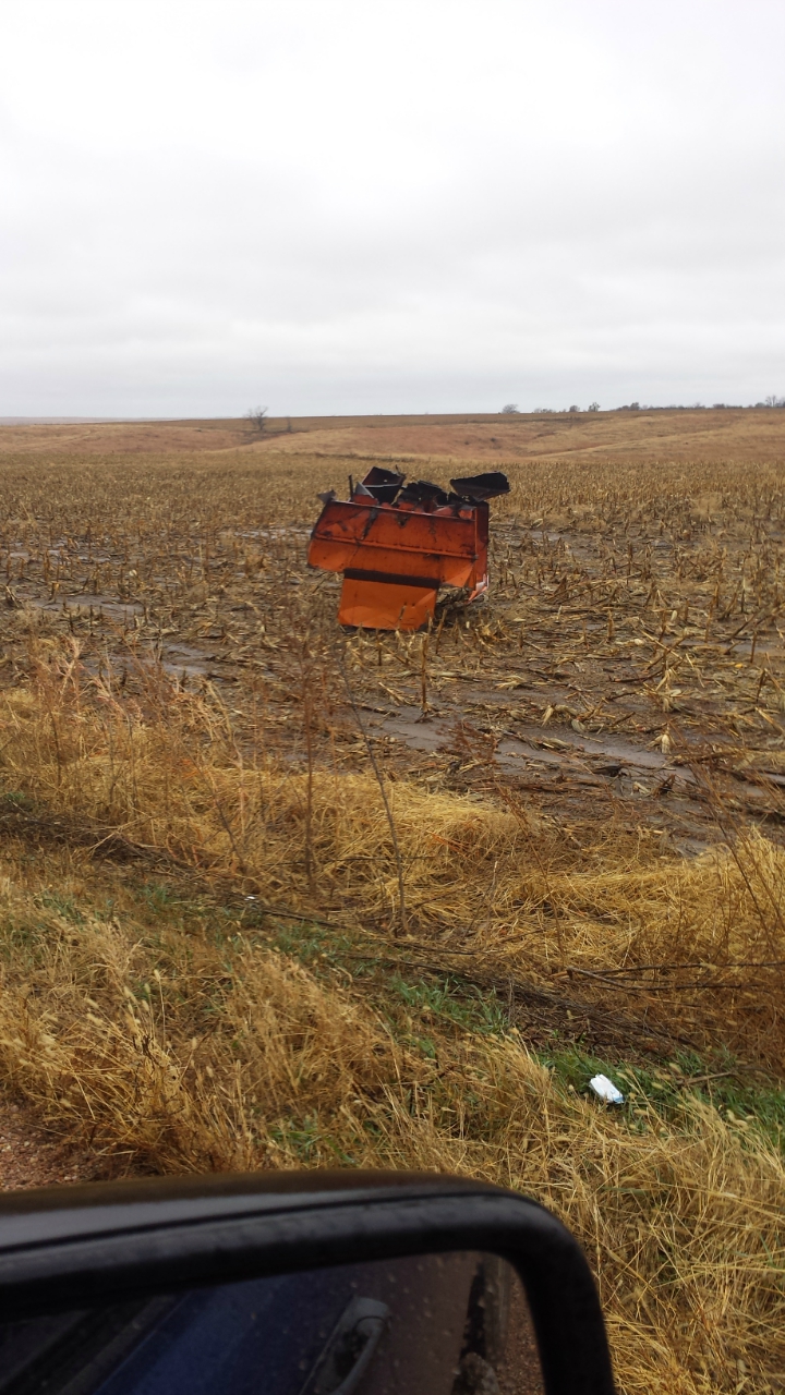
This tornado traveled north-northeast across rural areas of Furnas County south of Hollinger. It damaged mainly power poles and trees south of Highway 89. After it crossed Highway 89, the tornado clipped a barn and farm storage area northeast of Hollinger. The western side roof covering was ripped from the barn and several grain carts were moved on the property, causing other damage. The tornado likely lifted a mile or so north of this location.
The total path length was 12.75 miles with a maximum width of 400 yards (about 1200 feet). The maximum width was estimated from damage located approximately 4 miles north of the Kansas state line. During most of its path, the tornado was likely less than 100 yards wide.
Damage along the path was primarily confined to trees, power poles, some signs, the barn and some small farm machinery.
 |
 |
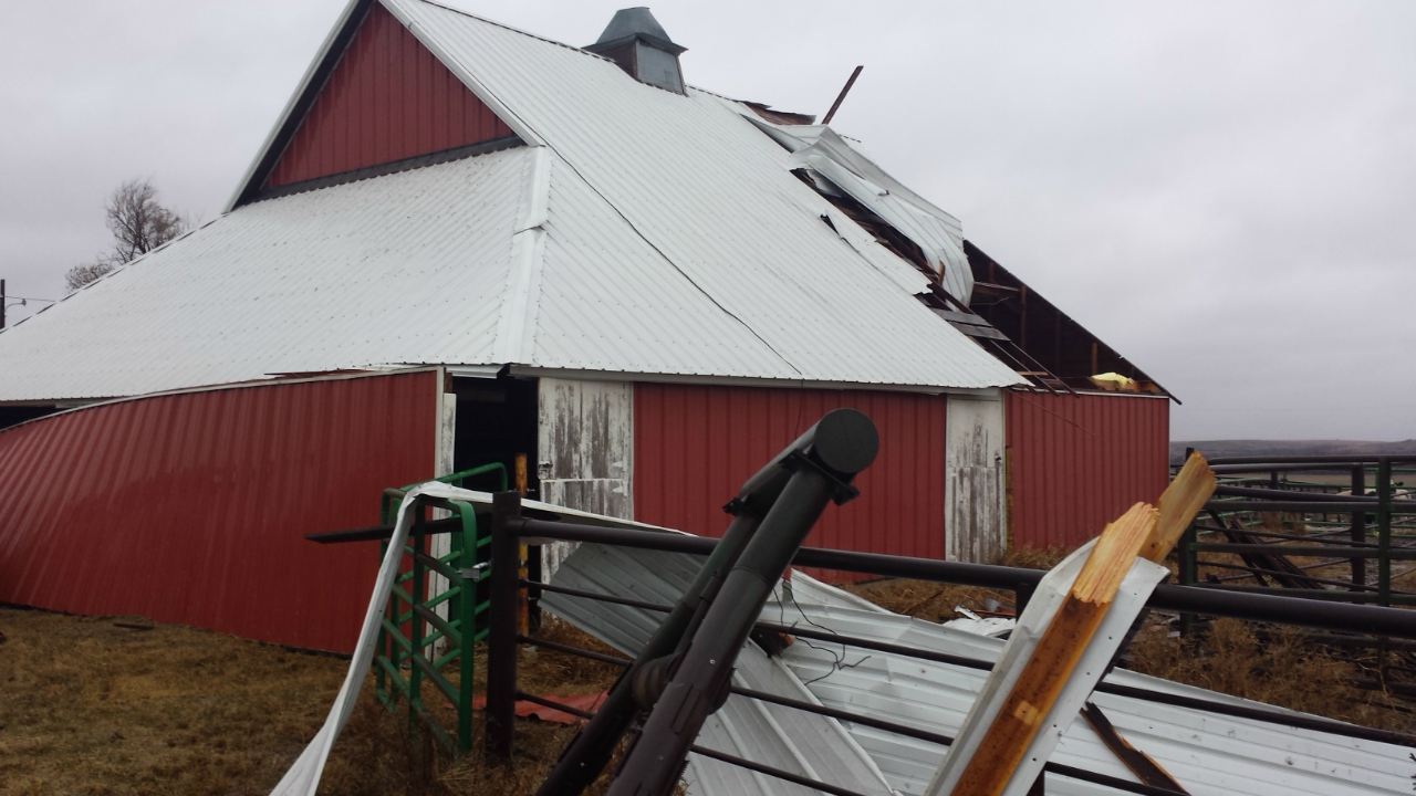 |
| Photos of damage along the path of the tornado, taken by NWS Hastings Survey Team. | ||
Over the two day period the region was under the influence of this strong upper level system, unusually abundant precipitation for November fell across the area. The entire NWS Hastings coverage area saw rainfall, but accumulating snowfall late in the event was primarily confined to the western half. Below are some of the higher amounts.
All snowfall totals are from NWS Cooperative Observers unless noted. Locations followed by a * indicate a CoCoRaHS/NeRAIN Observer or other source.
| Location | Snowfall (inches) |
| 6 SSE Lexington (Canaday Steam Plant) | 5.7 |
| 5 WNW Elm Creek* | 4 |
| 10 NNE Arapahoe* | 4 |
| Wilsonville | 4 |
| Miller | 3.6 |
| Bertrand* | 3.5 |
| 1 E Lexington* | 3 |
| Cambridge | 3 |
| 6 S Beaver City* | 2.8 |
| 4 ESE Sumner* | 2 |
| Edison | 1 |
| 4 S Cozad* | 1 |
These are 48 hour precipitation totals ending at 8 a.m. CST Wednesday, November 18th, all from NWS Cooperative Observers unless indicated. Both rain and melted snow are included in these totals.
| Location | Liquid (inches) |
| Loup City | 2.96 |
| 6 SSE Lexington (Canaday Steam Plant) | 2.67 |
| Cambridge | 2.48 |
| Edison | 2.37 |
| Ravenna | 2.26 |
| Ord | 2.18 |
| Wilsonville | 2.17 |
| Arcadia | 2.09 |
| Miller | 2.08 |
| St. Paul | 1.99 |
| 8 S Elwood | 1.96 |
| Greeley | 1.82 |
| 4 WNW Plainville, KS | 1.70 |
| Natoma, KS | 1.65 |
| Hebron | 1.64 |
| Kearney Airport | 1.62 |
| Holdrege | 1.62 |
| Minden | 1.59 |
| Lebanon, KS | 1.58 |
| 2 SW Alton, KS | 1.57 |
| Cawker City, KS | 1.55 |
| 3 N York | 1.38 |
| Grand Island airport (automated) | 1.37 |
| Jewell, KS | 1.35 |
| Clay Center | 1.35 |
| Belgrade | 1.35 |
| Ionia, KS | 1.33 |
| Franklin | 1.26 |
| Bruning | 1.25 |
| Burr Oak, KS | 1.21 |
| Mankato, KS | 1.20 |
| Osceola | 1.19 |
| 3 NE Shelby | 1.15 |
| Bradshaw | 1.14 |
| Hastings airport (automated) | 1.11 |
| Logan, KS | 1.03 |
 |
This page was composed by the staff at the National Weather Service in Hastings, Nebraska. |
 |

