
A significant heat wave continues for the Rockies, Northern Plains, and Great Lakes into the Mid-Atlantic, peaking in intensity through midweek and lingering across parts of the Northern Plains and Midwest until this weekend. Excessive rainfall my bring life-threatening and locally catastrophic flash and urban flooding across portions of southwestern Texas through early Friday. Read More >
The following information mainly focuses on climate and weather highlights for the month of Nov. 2016 (and also some info for "meteorological fall" Sep-Nov) across the NWS Hastings coverage area, encompassing 24 counties in south central/central Nebraska, and 6 counties in north central Kansas. Click here for a map of this coverage area. The temperature and precipitation data presented here are largely based on the NWS Cooperative Observer network, along with data from a handful of automated airport sites. All climate averages and "normals" presented here are based on the official NCEI 1981-2010 normals.
"Two-sentence summary" for Nov. 2016: November featured well-above average warmth across our entire 30-county area (easily one of the Top-10 warmest on record at generally 6-7º above normal). Precipitation-wise, most areas were generally "near-normal", with slightly above normal prevailing in the Nebraska Tri Cities area.
Please refer to the images below for:
1) a "quick glance" at Nov. 2016 precipitation and specific totals for several official NWS stations across the area.
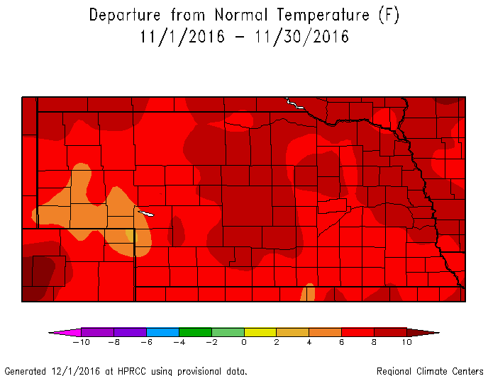
2) Nov. 2016 monthly temperature departure-from-normal maps for both Nebraska and Kansas
3) specific Nov. 2016 and Fall 2016 (Sep-Nov) temperature/precipitation details for Grand Island and Hastings airports, our two primary long-term climate data sites for which we routinely issue information/records
 |
| This graphic features an area precip map for Nov. 2016, along with a partial listing of official totals from official NWS stations. This map was generated from the AHPS precipitation analysis page at water.weather.gov/precip (click image to enlarge) |
 |
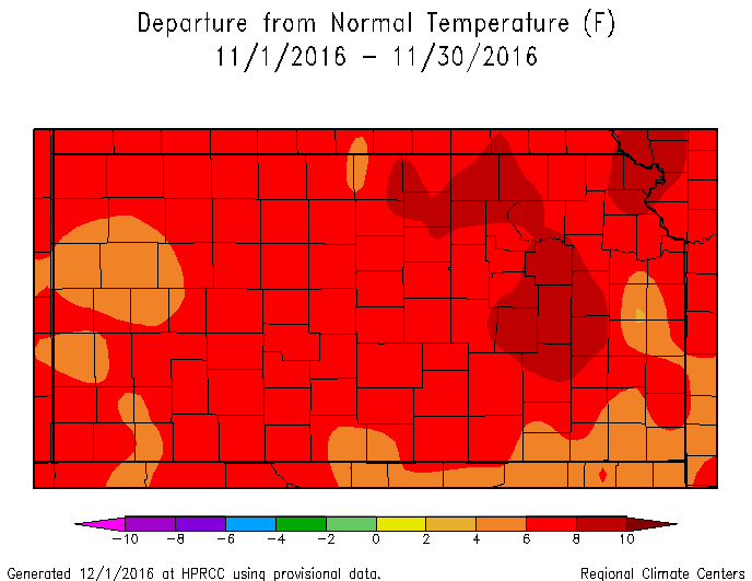 |
| These images depict Nov. 2016 monthly temperature departure-from normal for both Nebraska (left) and Kansas (right). Images courtesy of High Plains Regional Climate Center (HPRCC) (click images to enlarge) |
|
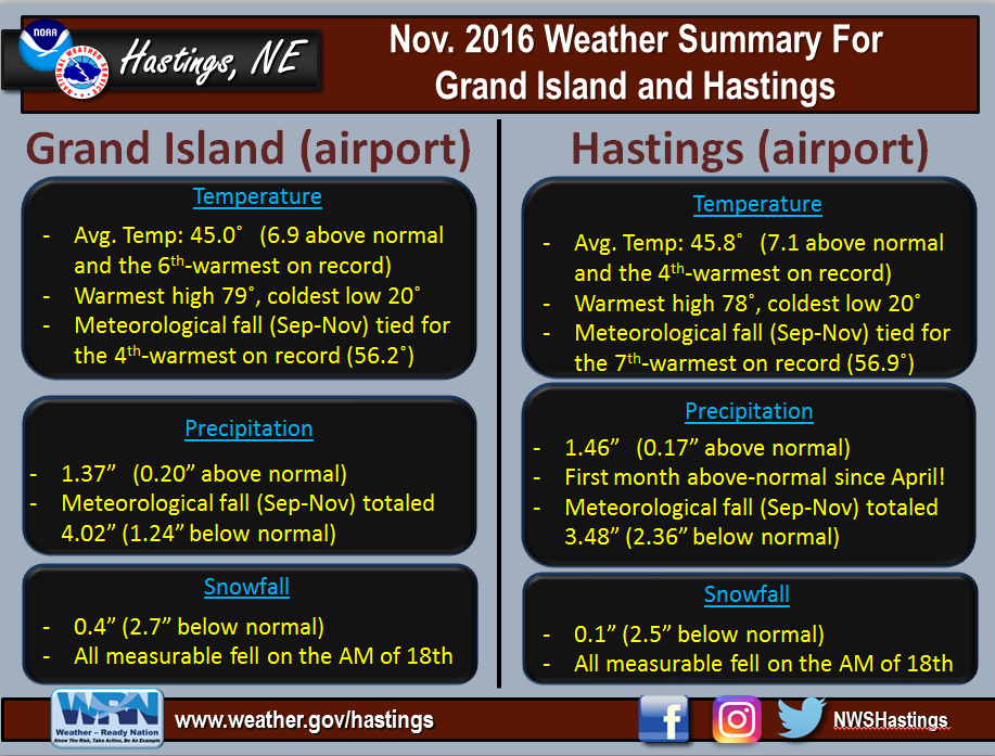 |
| This graphic presents detailed Nov. 2016 temperature/precipitation information specifically for Grand Island and Hastings airports, our two primary long-term climate sites for which we issue climate records and statistics. (click image to enlarge) |
 |
Media use of NWS Web News Stories is encouraged! Please acknowledge the NWS as the source of any news information accessed from this site. |
|

