
A significant heat wave continues for the Rockies, Northern Plains, and Great Lakes into the Mid-Atlantic, peaking in intensity through midweek and lingering across parts of the Northern Plains and Midwest until this weekend. Excessive rainfall my bring life-threatening and locally catastrophic flash and urban flooding across portions of southwestern Texas through early Friday. Read More >
The following information mainly focuses on climate and weather highlights for the month of October 2016 across the NWS Hastings coverage area, encompassing 24 counties in south central/central Nebraska, and 6 counties in north central Kansas. Click here for a map of this coverage area. The temperature and precipitation data presented here are largely based on the NWS Cooperative Observer network, along with data from a handful of automated airport sites. All climate averages and "normals" presented here are based on the official NCEI 1981-2010 normals.
"One-sentence summary" for Oct. 2016: October featured above-average warmth across our entire 30-county area, and WELL-BELOW average rainfall across most (but not all) of the area, as some of our far eastern counties (mainly along Highway 81) actually received near-to-slightly-above normal rain.
Please refer to the three images below for a "quick glance" at local weather/climate in Oct. 2016, and also a list of some of the wettest/driest rainfall totals for June-October (the past 5 months):
 |
| This graphic features an area rainfall map for Oct. 2016, along with a partial listing of official rainfall totals. This map was generated from the AHPS precipitation analysis page at water.weather.gov/precip |
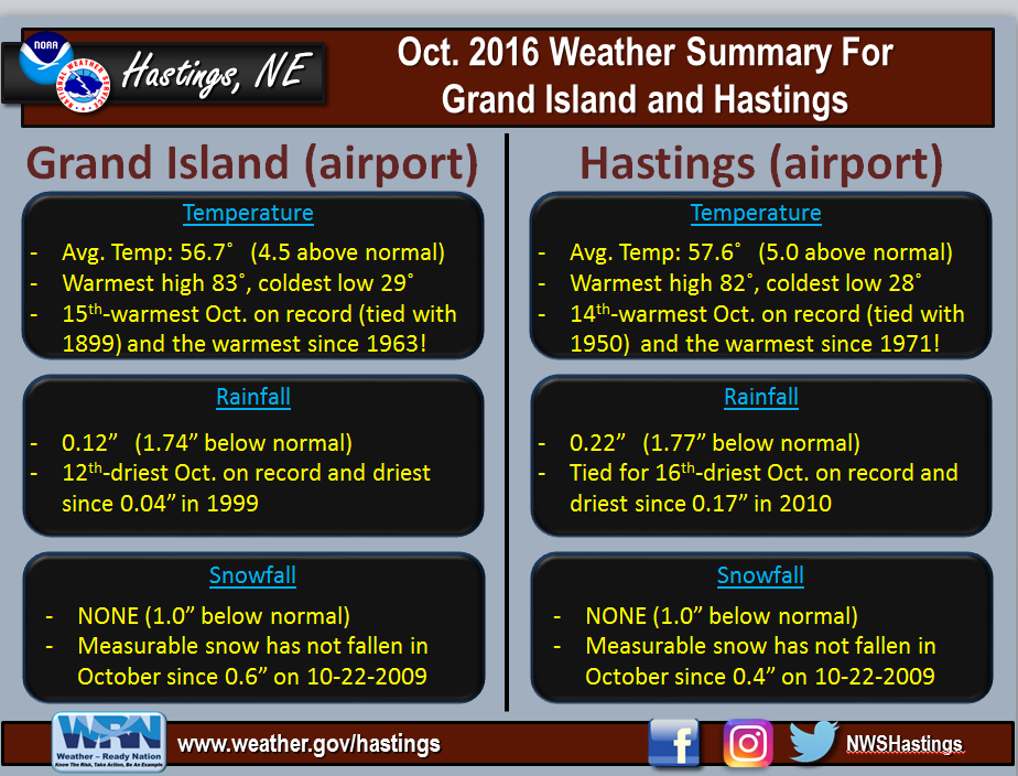 |
| This graphic presents detailed Oct. 2016 temperature/rainfall information specifically for Grand Island and Hastings airports, our two primary long-term climate sites for which we issue climate records and statistics. |
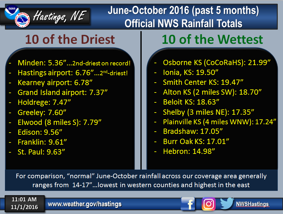 |
| This graphic outlines the stark difference in rainfall totals across our coverage area from June-October 2016 (the past 5 months), as some areas have slipped into drought while others have observed adequate and even slightly above-normal rain. For the most part, the driest areas have focused within the heart of South Central Nebraska (including the Tri Cities), while in sharp contrast, the wettest areas have concentrated within North Central Kansas and also local Nebraska counties along the Highway 81 corridor. |
 |
Media use of NWS Web News Stories is encouraged! Please acknowledge the NWS as the source of any news information accessed from this site. |
|

