
Dangerous and extreme heat will remain across portions of the southern U.S. through the weekend. A heat wave over the Southwest U.S. will intensify this week, peaking and expanding into the Intermountain West and northern High Plains this weekend. Multiple rounds of thunderstorms will produce heavy to excessive rainfall with significant flash flooding across portions of southern New England. Read More >
|
|
|
1. Event overview On the early afternoon of June 12, 2002, severe storms produced hail in Kearney County, and small, brief tornadoes in Rooks and Phillips Counties in North Central Kansas. The storms initiated in response to a southward moving cold front that slid through the region during the day. A second round of thunderstorms developed later in the afternoon producing 3.5 inch diameter hail near York, and 4.5 inch diameter hail in Riverdale, and Minden. Considerable hail damage occurred in portions of Kearney where hail was reported greater than 4.5 inches in diameter, resulting in vehicle, roof, and tree damage. The Plains Produce greenhouse east of Minden sustained major glass damage.
|
|
The following analyzed surface map depicts general meteorological conditions across the region, at 7 PM local time (Fig. 1).
|
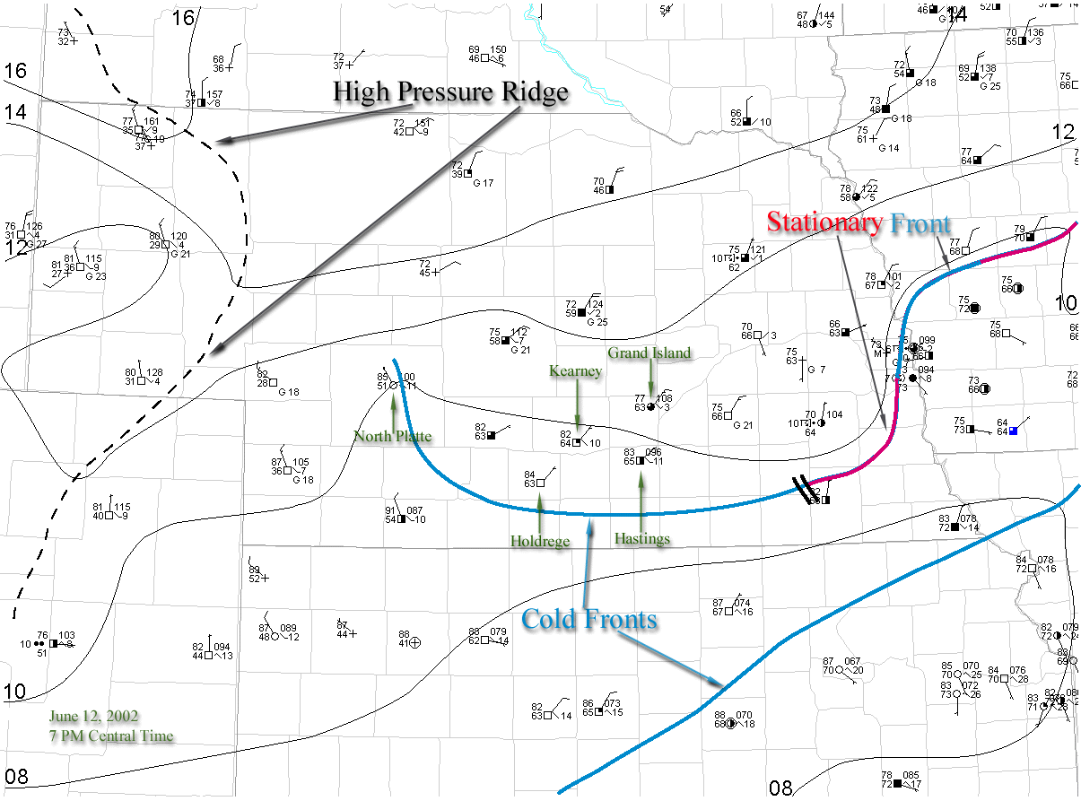 |
Fig. 1. Surface map for 7 PM 12 June 2002 with subjectively analyzed mean sea level pressure (solid) contoured every 2 mb. Standard station model used; temperature and dewpoint (°F), pressure (mb), 3-h pressure tendency (mb), and sky conditions reported. Winds in knots with one full barb, and one half barb equal to 10, and 5 knots, respectively. Fronts and pertinent surface features depicted. |
|
The large hail that fell in Kearney and Minden was associated with a supercell thunderstorm (Storm A) that developed in Custer County, along and on the cold side (north) of the surface cold front (Fig. 2). The storm moved southeast at ~35 mph impacting portions of Custer, Buffalo, Kearney, Webster and Franklin Counties, with heavy rain, strong winds, and at times, hail up to and exceeding 4.5 inches. |
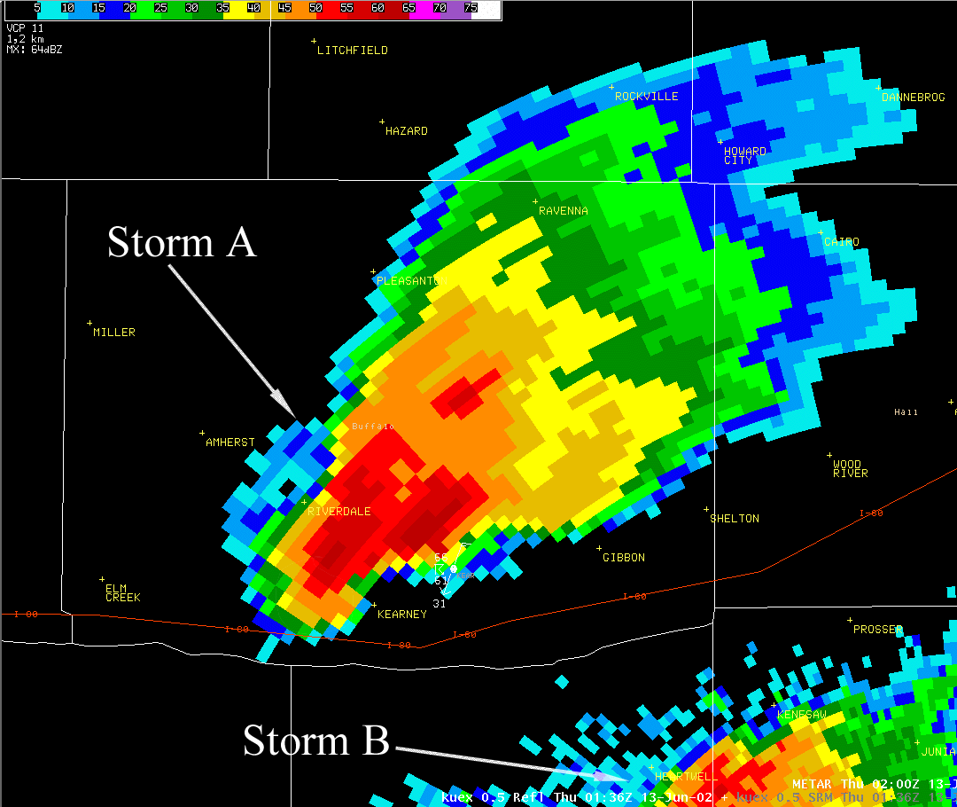 |
Fig. 2. Radar reflectivity of Storm A just as the storm arrived into Kearney, valid for 8:36 PM local, 12 June 2002. |
|
A smaller supercell (Storm B) developed concurrently with Storm A in Kearney County, and tracked to the southeast at ~35 mph, impacting portions of Kearney, Adams, Webster, Nuckolls, and Jewell Counties. Hail up to 1.75 inches was reported with the storm (Fig. 3). |
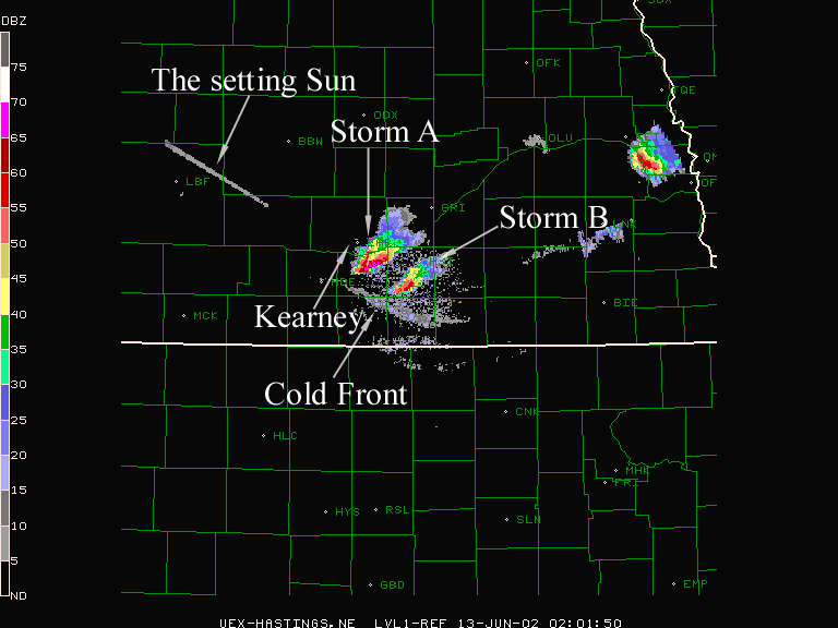 |
Fig. 3. Radar reflectivity valid for 9:01 PM local, 12 June 2002. Relevant features depicted. |
|
A plot of the hail swaths associated with both storms reveals the extent of hail coverage and path lengths. Please note, the plot was based on the preliminary local storm report (see below) and damage surveys conducted by the Hastings National Weather Service Office (Fig. 4). |
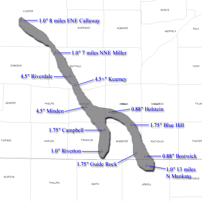 |
Fig 4. Hail swaths associated with storms A and B for 12 June 2002. |
|
On June 13 2002, the Hastings National Weather Service Office conducted a damage survey documenting the extent of the hail and wind damage in the city of Kearney and surrounding areas (Fig. 5). Please note the figure was based on the survey and from damage reports received from the Buffalo County Office of Emergency Management. In Kearney, the majority of the greatest widespread hail damaged occurred in the northwest portion of town with scattered damage across eastern sections of the City.
|
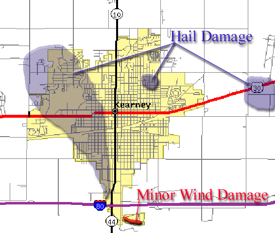 |
Fig. 5. Preliminary damage survey of the City of Kearney. The map should be viewed as greatly generalized and preliminary. |
|
PRELIMINARY LOCAL STORM REPORT
NATIONAL WEATHER SERVICE HASTINGS NE
TIME(CDT) CITY LOCATION STATE EVENT/REMARKS COUNTY LOCATION 0610 AM CAWKER CITY KS .75 INCH HAIL 06/12/02 MITCHELL 1225 PM 8 NNE AXTELL NE 1 INCH HAIL 06/12/02 KEARNEY REPORTED BY STORM SPOTTER. 1245 PM 4 W NEWARK NE 1 INCH HAIL 06/12/02 KEARNEY REPORTED BY STORM SPOTTER. 0121 PM 9 NW STOCKTON KS TORNADO 06/12/02 ROOKS REPORTED BY LAW ENFORCEMENT OFFICIAL. 0125 PM 3 SW GLADE KS TORNADO 06/12/02 PHILLIPS REPORTED BY LAW ENFORCEMENT OFFICIAL. 0310 PM 8 NE NELSON NE .75 INCH HAIL 06/12/02 NUCKOLLS REPORTED BY PUBLIC. 0339 PM 10 S PLAINVILLE KS TORNADO 06/12/02 ROOKS REPORTED BY PUBLIC. 0513 PM CLARKS NE 1.75 INCH HAIL 06/12/02 MERRICK REPORTED BY LAW ENFORCEMENT OFFICIAL. 0537 PM 5 SW STROMSBURG NE 1.75 INCH HAIL 06/12/02 POLK REPORTED BY LAW ENFORCEMENT OFFICIAL. 0542 PM 3 W STROMSBURG NE 1.75 INCH HAIL 06/12/02 POLK REPORTED BY LAW ENFORCEMENT OFFICIAL. 0550 PM 3 W GRESHAM NE 1 INCH HAIL 06/12/02 YORK REPORTED BY COOPERATIVE OBSERVER.
0600 PM    7 NW YORK                 NE   3.5 INCH HAIL   06/12/02   YORK           REPORTED BY COOPERATIVE OBSERVER.

0805 PM    7 NNE MILLER              NE   1 INCH HAIL     06/12/02   BUFFALO        EVENT DURATION 5 MINUTES.
                                                                                    REPORTED BY STORM SPOTTER.
0840 PM KEARNEY NE 4.5 INCH HAIL 06/12/02 BUFFALO REPORTED BY EMERGENCY MANAGEMENT. 0845 PM 9 NNW MINDEN NE 2.75 INCH HAIL 06/12/02 KEARNEY 0845 PM KEARNEY NE 1.5 INCH HAIL 06/12/02 BUFFALO REPORTED BY LAW ENFORCEMENT OFFICIAL. 0855 PM 6 N MINDEN NE 1.25 INCH HAIL 06/12/02 KEARNEY REPORTED BY STORM SPOTTER. 0905 PM MINDEN NE 4.5 INCH HAIL 06/12/02 KEARNEY REPORTED BY EMERGENCY MANAGEMENT. 0908 PM MINDEN NE 2.5 INCH HAIL 06/12/02 KEARNEY REPORTED BY HAM RADIO OPERATOR. |

