
Dangerous heat will expand from the Gulf Coast into the Southern Plains and Desert Southwest through week's end. Additional extreme heat impacting the Pacific Northwest will shift to the northern Plains by the weekend. Tropical Storm Bertha is expected to continue to impact portions of the northern Gulf Coast from the western Florida Panhandle to southeastern Louisiana through tonight. Read More >
Overview
|
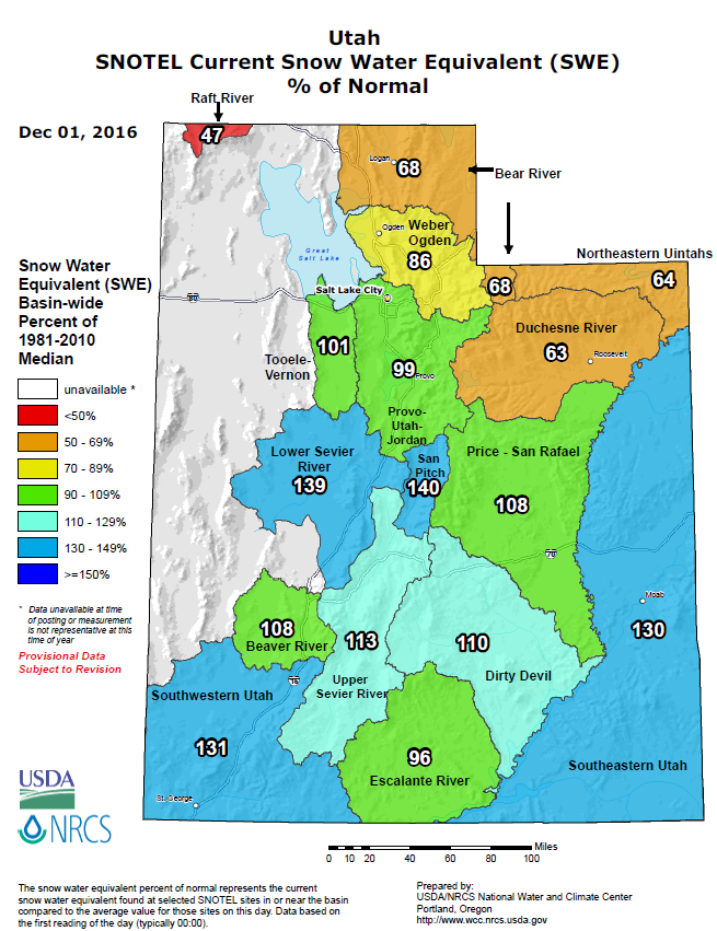
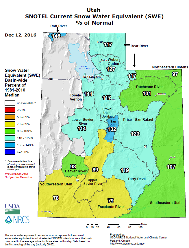
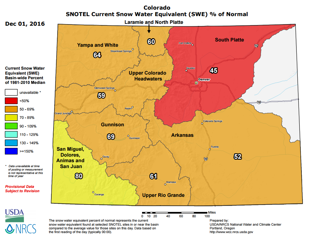
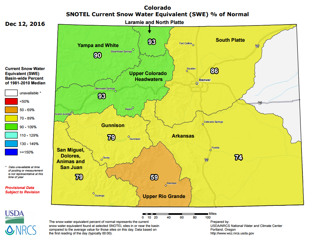
A series of mild and moist Pacific storms moved across the Central Rockies bringing heavy snow to the mountains of northern and central Colorado. The mild temperatures brought a mixed bag of precipitation to the valleys with rain, snow and even freezing rain reported at several locations. Winds gusting to 50 mph were common over the higher mountains with widespread blowing and drifting snow reported. Major travel impacts were experienced along Interstate 70 over Vail Pass and along U.S. Highway 40 over Rabbit Ears Pass. Snowfall amounts varied from 8 to 20 inches over the mountains with lighter amounts across the valleys. A few of the reports are located in the Storm Reports tab located below. The maps below show the state of the snow-pack for Utah and Colorado by measuring the water content of the snow (known as snow water equivalent (SWE)). We show you the snowpack as of December 1st and again after the latest storm for Utah and Colorado. |
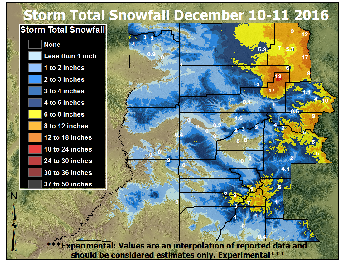 Observed Snowfall over the Weekend |
 |
 |
 |
 |
| Snow Water Equivalent (SWE) percentage of normal in Utah as of 12/01/2016 |
Snow Water Equivalent (SWE) percentage of normal in Utah as of 12/12/2016 |
Snow Water Equivalent (SWE) percentage of normal for Colorado as of 12/01/2016 | Snow Water Equivalent (SWE) percentage of normal for Colorado as of 12/12/2016 |
Snow/Ice
Rain and snow showers developed across the area around midday on Saturday, December 10, 2016 as a strong upper level jet stream and several waves of Pacific moisture and energy moved through. Snow levels actually rose during the late afternoon and overnight hours Saturday and Saturday night as warmer air aloft moved in. This caused snow that was falling to change over to rain in some of the valleys. However, due to strong inversions, temperatures were still below freezing in the valleys and the rain ended up freezing on contact with the cold surface, especially on automobiles, bridges and overpasses.
So even though the temperatures were below freezing on the ground, a warm layer above the surface caused snow to turn to rain and eventually lead to the freezing rain observed in a few locations late Saturday night and early Sunday morning. This narrow band of warmer air aloft did not impact the mountains and snow continued to fall through midday Sunday, before ending from west to east. By late Sunday afternoon, this storm was moving out of the area replaced by mostly sunny and mild conditions, even with the freshly fallen rain, freezing rain and snow.
Photos & Video:
Header
 |
 |
 |
| Frozen Path from Freezing Rain (Daniel Amerman) |
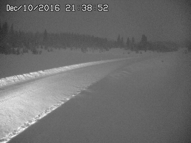
Rabbit Ears Pass at Night (CDOT) |
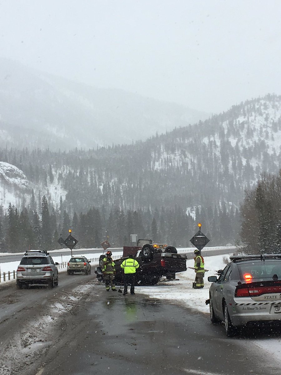
Accident headed up Vail Pass (CSP Eagle) |
Storm Reports
Public Information Statement
National Weather Service Grand Junction CO
643 PM MST Sun Dec 11 2016

...Preliminary 48 Hour Snowfall Reports...
Here is a preliminary list of snowfall reports in our area
over the past 48 hours. These reports are comprised of UCOOP
observers and COCORAHS reports. This was a warm event so snowfall
at many valley locations is relatively low, ranging from 0 to
2 inches. However, storm verification efforts for the mountain
locations in northwest and central Colorado showed 48 hour
snowfall ranging from 8 to 20 inches of snow! The Flattops
received the most with 15 to 20 inches, follow by the Elkhead
and Park ranges received 9 to 17 inches in the 48 hour period.

Location                     Amount    Time/Date       Provider

...Colorado...

...Eagle County...
Vail 2.6 E                   5.5 in    0700 AM 12/11   COCORAHS
Vail 0.9 WNW                 5.4 in    0700 AM 12/11   COCORAHS
Wolcott 2n                   1.1 in    0700 AM 12/11   UCOOP
Wolcott 2.3 N                1.1 in    0700 AM 12/11   COCORAHS

...Gunnison County...
Crested Butte 6.2 N          7.5 in    0700 AM 12/11   COCORAHS
Gothic                       7.5 in    0700 AM 12/11   UCOOP
Gunnison 6.6 N               2.3 in    0700 AM 12/11   COCORAHS
Gunnison 3wsw                2.0 in    0700 AM 12/11   UCOOP

...La Plata County...
Rockwood 6.7 N               3.8 in    0700 AM 12/11   COCORAHS
5 W Vallecito                1.0 in    0700 AM 12/11   COCORAHS

...Mesa County...
Collbran                     1.7 in    0800 AM 12/11   UCOOP
Collbran 0.2 ESE             1.6 in    0700 AM 12/11   COCORAHS
3 E Plateau City             1.4 in    0700 AM 12/11   COCORAHS
17 W Glade Park              0.4 in    0800 AM 12/11   COOP
1 W Fruitvale                0.1 in    0700 AM 12/11   COCORAHS
Grand Junction 4.0 W         0.1 in    0700 AM 12/11   COCORAHS

...Routt County...
Steamboat Springs 0.7 ESE    8.5 in    0700 AM 12/11   COCORAHS


...Uintah County...
Vernal                       0.9 in    0630 AM 12/11   COOP

Observations are collected from a variety of sources with varying
equipment and exposures. Not all data listed are considered official.

$$

NWS Grand Junction CO
IRIS System
 |
Media use of NWS Web News Stories is encouraged! Please acknowledge the NWS as the source of any news information accessed from this site. |
|

