
A significant heat wave is underway for the Intermountain West, Northern Plains, and Upper Great Lakes, peaking in intensity through midweek and lingering across parts of the Northern Plains and Midwest until this weekend. In southwest Texas, excessive rainfall may bring a risk for potentially life-threatening flash and arroyo flooding through Thursday. Read More >
Grand Junction, CO
Weather Forecast Office
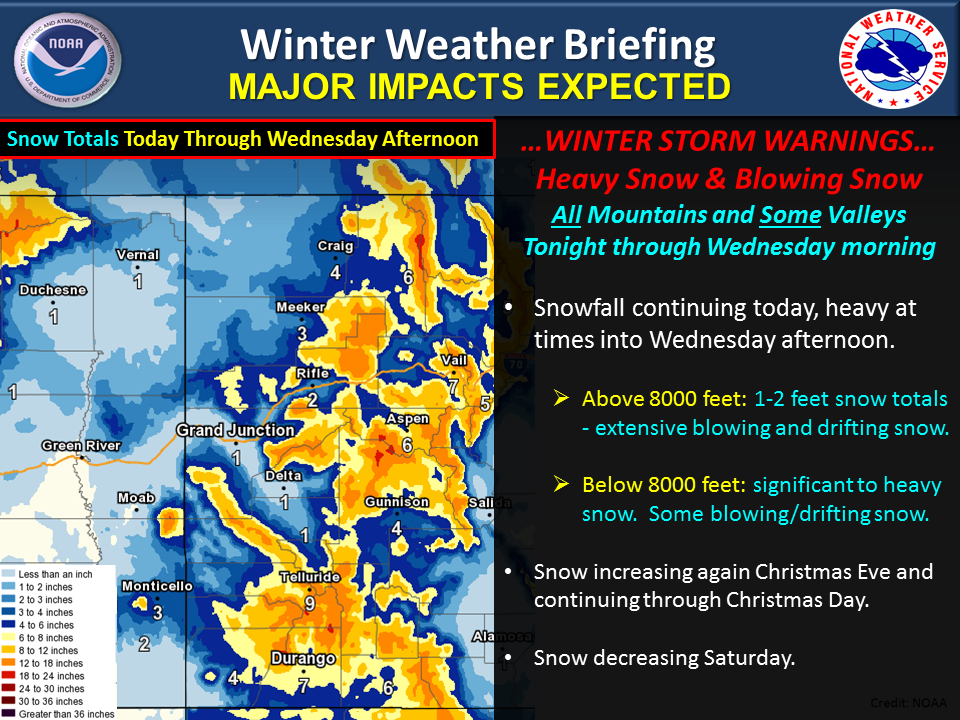
A major winter storm will impact eastern Utah and western Colorado today into Wednesday afternoon. Heavy snowfall, as well as extensive blowing and drifting snow will occur in the mountains and some lower elevation areas. Snowfall storm totals of 1 to 2 feet are expected in the mountains above the 8000 foot level, with lesser amounts at lower elevations.
Please avoid any unnecessary travel into the warned areas. If travel is necessary, please make sure your vehicle is roadworthy for winter driving conditions and allow extra time for travel. It is also recommended that you carry a winter survival kit with you when traveling during the winter season.
.PNG)
Speaking of winter, the onset of this winter storm was coincident with the 2015 winter solstice which occurred at 9:48 PM MST on December 21st.
Another winter snowfall event is then expected across the central intermountain region Christmas Eve and continuing through Christmas Day. Stay tuned for updates!
Hazards
Detailed Hazards Viewer
National Briefing
Outlooks
Transportation Decision Support
Winter Storm Severity Index
Forecasts
Aviation Weather
Fire Weather
Forecast Discussion
Forecast Points
Local Area
Severe Weather
Soaring Forecast
Winter Weather
Hydrology
Recreational River Report
River Forecast
Weather Safety
Preparedness
NOAA Weather Radio
StormReady
SkyWarn
US Dept of Commerce
National Oceanic and Atmospheric Administration
National Weather Service
Grand Junction, CO
2844 Aviators Way
Grand Junction, CO 81506-8644
970-243-7007
Comments? Questions? Please Contact Us.

