A couple of frontal boundaries will move east and south from the Plains to the Gulf and Atlantic coastlines. These boundaries will focus showers and thunderstorms through the weekend, with scattered severe thunderstorms from the Southern Plains and across the Gulf Coast states. Locally heavy rainfall may also occur, which may be welcome news across drought areas. Meanwhile, heat spreads westward. Read More >
Overview
|
During the early morning hours of 09 January 2017, freezing rain developed across several valley locations in western Colorado. The resultant ice accumulation created widespread power outages near Steamboat Springs and Durango, Colorado. Travel conditions were extremely treacherous with hundreds of vehicle accidents reported in the vicinity of Grand Junction, Colorado and near Durango. First responders were overwhelmed at the volume increase of emergency calls and secondary services were requested from nearby municipalities to help work the increased workload. The emergency operations center in Mesa County Colorado (Grand Junction) was activated as a result of the numerous accidents and injuries across the region. The widespread impact of this ice event has not been experienced in western Colorado in over 100 years of climate record keeping. The ice storm occurred during an Atmospheric River (AR) event that was categorized as extreme when it impinged upon the central and northern California coast beginning 08 January 2017. The strength of this AR event increased the probability of impacts farther inland which was realized over western Colorado on the morning of 09 January 2017. This anomalous moisture source was continually utilized throughout the weekend as several embedded shortwaves tracked across the region. These waves of energy served to enhance the persistent orographic lift across the Colorado mountain ranges; the outcome being periods of especially heavy snowfall rates. Along the Continental Divide storm total snowfall measurements of 1 to 2 feet were common with up to 4 feet of snow reported over the Elk Mountains of central Colorado by the storm's end on 10 January 2017. To reinforce how moist the atmosphere was throughout the storm, forecast precipitable water (PWAT) values ran 160% to 240% above the climatological normal. Prior to the AR event, strong surface inversions were in place across many valley locations with daytime highs generally remaining in the mid to upper teens. The temperature forecast for the valleys was a challenge since there was not a great consensus between model guidance and local forecast knowledge on whether or not the inversions would mix out. The main reason for this was the influx of anomalously warm and moist mid-level temperatures that were forecast to arrive late in the weekend within this progressive weather pattern. If the inversions were to remain in place, the warm air would be able to rise above the cold domes and introduce the potential for mixed precipitation to the valleys. Conversely, if the inversions were to mix out rain and or snow could be the outcome. Strong warm air advection moved into the region on 08 January 2017, eroding some of the inversions in a few valley locations in northwest Colorado such as Craig and Meeker which had daytime highs of 34°F and 37°F, respectively. This was quite an impressive recovery in temperatures considering lows in these areas 36 hours prior ranged between -22°F and -30°F. Elsewhere, cities in the central and southern Colorado valleys as well as across portions of eastern Utah remained under their inversions. However, mid-level warming would continue to amplify over the next 24 hours as a warm front pushed north into central Wyoming which, when combined with enhanced southwesterly flow ahead of an approaching cold front, would increase the chance for inversions to mix out. The night of 08 January saw low-level boundary layer conditions become favorable for freezing precipitation after clearing skies and recent snowfall enhanced temperature inversions. The morning of Monday, 09 January, the effect of the strong thermal belt aloft was greatly felt. In the early morning hours, Grand Junction (elevation 4858 ft) was sitting at 18°F just before 0300 MST and Telluride (elevation 9070 ft) was at 43°F. Conditions quickly changed within a few hours down south with the airport in Durango, Colorado sitting at 33°F just before 0800 MST. Meanwhile, in the Grand Valley, surface temperatures remained in the 24°F to 27°F range as of 0900 MST as the inversion held strong. By that time, around a quarter inch of ice had already accrued on numerous surfaces. Late that afternoon, most valleys eventually climbed above freezing (though Grand Junction itself only rose to 32°F as of 1500 MST) as the warm nose mixed down to the surface. The arrival of the cold front during the afternoon and evening hours saw the return of colder air aloft which finally put to rest all threats of freezing precipitation. The warm spot of the day in Craig, Colorado cooled to 30°F behind the front. The 09 January 2017 ice storm was a 1 in 100 year event for the western slope of Colorado and brought major impacts to Mesa, Delta, Garfield, and La Plata counties as well as minor impacts to Montrose, Gunnison, and Routt counties. Minor impacts were also reported in Grand County, Utah. |
.JPG) Ice Accumulation on Branches in Grand Junction, Colorado on 01-09-2017 (Credit: Michael Charnick) |
%20(2).jpg) |
.JPG) |
.jpg) |
| Fire Truck Sliding off I-70 near Grand Junction, CO (Credit: KKCO11 News) | Hazardous Travel near Durango, CO (Credit: Durango Herald) | Hazardous Travel on I-70 near Grand Junction, CO (Credit: Faith Marie Logan) |
Photos & Video
Hazardous Travel Across the Western Slope on 09 January 2017
.JPG) |
.jpg) |
 |
.jpg) |
| Ice in Grand Junction, CO (Credit: Michael Charnick) |
Ice on Car at NWS Grand Junction, CO (Credit: NWS) |
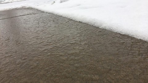
Ice at NWS Grand Junction, CO (Credit: NWS) |
Hazardous Travel near Durango, CO (Credit: Durango Herald) |
Environment
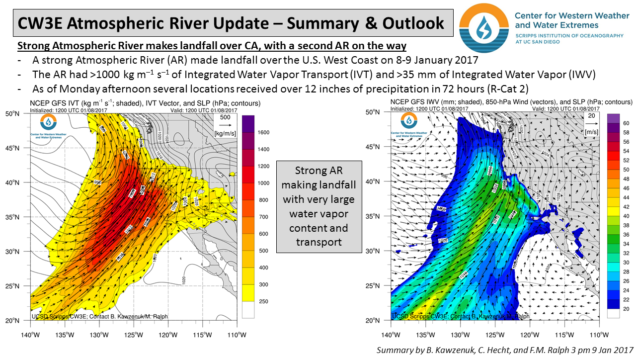
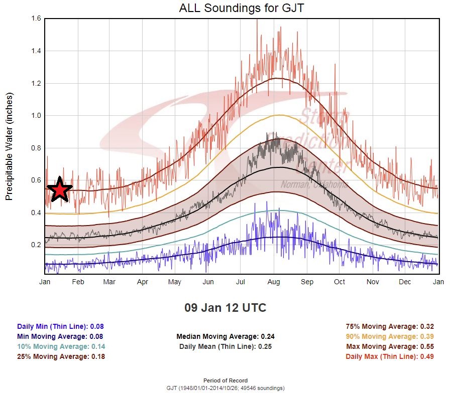
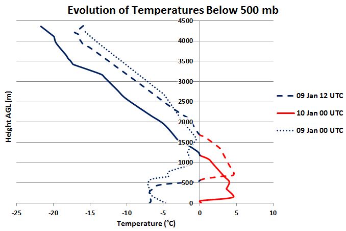
The ice storm occurred during an Atmospheric River (AR) event that was categorized as extreme when it impinged upon the central and northern California coast beginning 08 January 2017 (Figure 1). The strength of this AR event increased the probability of impacts farther inland which was realized over western Colorado on the morning of 09 January 2017. To reinforce how moist the atmosphere was throughout the storm, forecast precipitable water (PWAT) values ran 160% to 240% above the climatological normal (Figure 2). Additionally, the depth of the warm, Pacific air aloft associated with the extreme AR was a major forecast challenge in regards to how it would influence the ongoing persistent and strong valley inversions. The mild air aloft led to a classic "warm nose" on the morning (12Z) upper air sounding at the Grand Junction Airport (Figure 3).
 |
 |
 |
| Figure 1: 08 January 2017 AR summary and outlook update from the Center for Western Weather and Water Extremes (Credit: CW3E) | Figure 2: SPC sounding climatology at GJT plotting daily max PWAT record of 13.72 mm (0.54") | Figure 3: Evolution of Temperatures below 500mb at KGJT |
 |
Media use of NWS Web News Stories is encouraged! Please acknowledge the NWS as the source of any news information accessed from this site. |
 |