
Cooler and less humid conditions for most of the eastern third of the nation as high pressure dominates the weather pattern. Otherwise, rather tranquil weather for most of the nation for the end of the weekend into the start of this week. We continue to monitor a developing coastal storm offshore of the Carolinas; Coastal flooding and beach erosion possible along portions of the Mid-Atlantic. Read More >
Grand Junction, CO
Weather Forecast Office
Fourth of July Climatology for Eastern Utah and Western Colorado

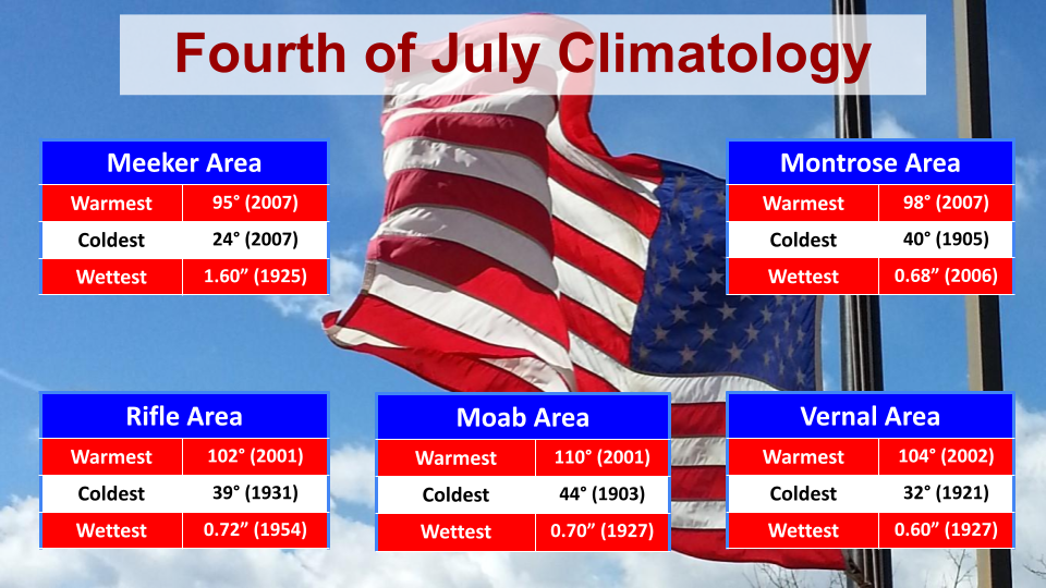
*Please note that all data mentioned is collected from our automated observing stations from 10 different airports across eastern Utah and western Colorado.*
Temperatures for the Fourth of July this year will be near to slightly above normal normal. Skies will be mostly clear, but afternoon showers and thunderstorms remain possible across the higher terrain. Please stay weather-aware as you enjoy the holiday.
For more climate information from other sites, please visit our climate page on our website at https://www.weather.gov/wrh/climate?wfo=gjt. You can also follow us on Facebook (@NWSGrandJunction) or Twitter (@nwsgjt).
Hazards
Detailed Hazards Viewer
National Briefing
Outlooks
Transportation Decision Support
Winter Storm Severity Index
Forecasts
Aviation Weather
Fire Weather
Forecast Discussion
Forecast Points
Local Area
Severe Weather
Soaring Forecast
Winter Weather
Hydrology
Recreational River Report
River Forecast
Weather Safety
Preparedness
NOAA Weather Radio
StormReady
SkyWarn

US Dept of Commerce
National Oceanic and Atmospheric Administration
National Weather Service
Grand Junction, CO
2844 Aviators Way
Grand Junction, CO 81506-8644
970-243-7007
Comments? Questions? Please Contact Us.


 Follow us on X
 Follow us on Facebook
 Follow us on YouTube
 GJT RSS Feed