
Severe thunderstorms which can bring large hail, damaging winds, and isolated tornadoes will be possible over parts of the central U.S. through this weekend. Thunderstorms with heavy to excessive rainfall moving from Texas into the mid-Mississippi Valley through this weekend may produce areas of flooding. Read More >
Overview
|
Monsoon moisture continued to be advected into eastern Utah and western Colorado from the south on Sunday, August 4, 2019. This resulted in scattered to numerous showers and thunderstorms across the region during the afternoon and evening hours as available moisture was at 120% of the climatological normal. Additionally, a passing shortwave disturbance enhanced the coverage and intensity of convection over western Colorado. All of these elements resulted in showers and thunderstorms that were producing heavy rainfall with some storms exceeding 0.50 to 1.00 inches per hour. As a result, significant flooding and debris flows occurred on the Lake Christine Fire burn scar near Basalt, Colorado, and along Fryingpan Road in particular during the evening hours on August 4. Fryingpan Road was closed for 3 hours due to debris cleanup and approximately 10 vehicles were stuck on the road. Additionally, roughly 30 homes were impacted and evacuation orders were in place for Cedar and Pinion Drives. |
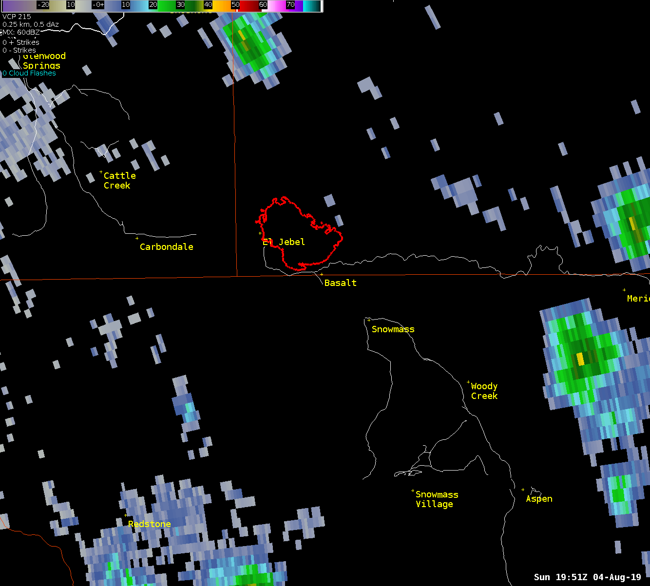 KGJX Radar Imagery Over Lake Christine Burn Scar on August 4, 2019 |
.jpg) |
.jpg) |
.jpg) |
| Fryingpan Road near Basalt, CO (Credit: Aspen Times) | Debris Removal Around Basalt, CO (Credit: Aspen Times) | Cedar Drive in Basalt, CO (Credit: Carbondale Fire) |
Photos & Video
Flash flooding and several mudslides occurred near Basalt, Colorado
.jpg) |
.jpg) |
.jpg) |
.jpg) |
| Upper Cedar Drive in Basalt, CO (Credit: Matt Donger) |
Fryingpan Road near Basalt, CO (Credit: Aspen Times) |
Additional Debris on Cedar Drive (Credit: Carbondale Fire) |
Fryingpan Road Closures (Credit: Aspen Times) |
Radar
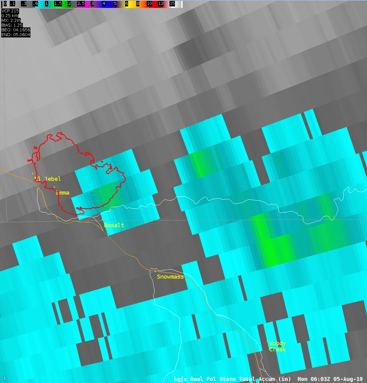
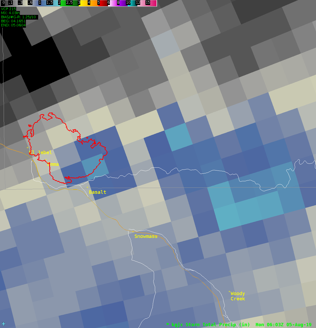
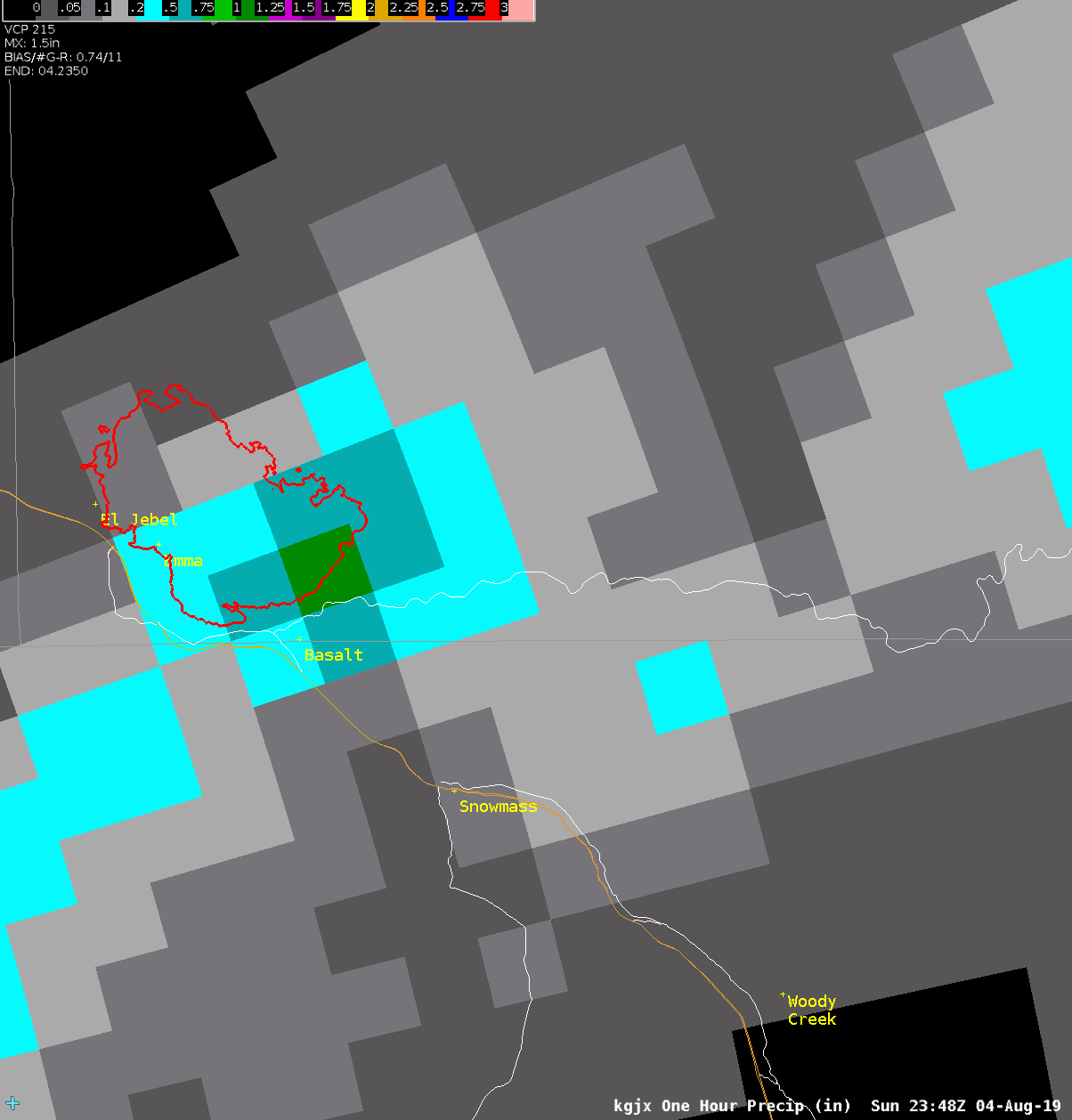
The following images show radar estimated rainfall during the Lake Christine burn scar flooding
 |
 |
 |
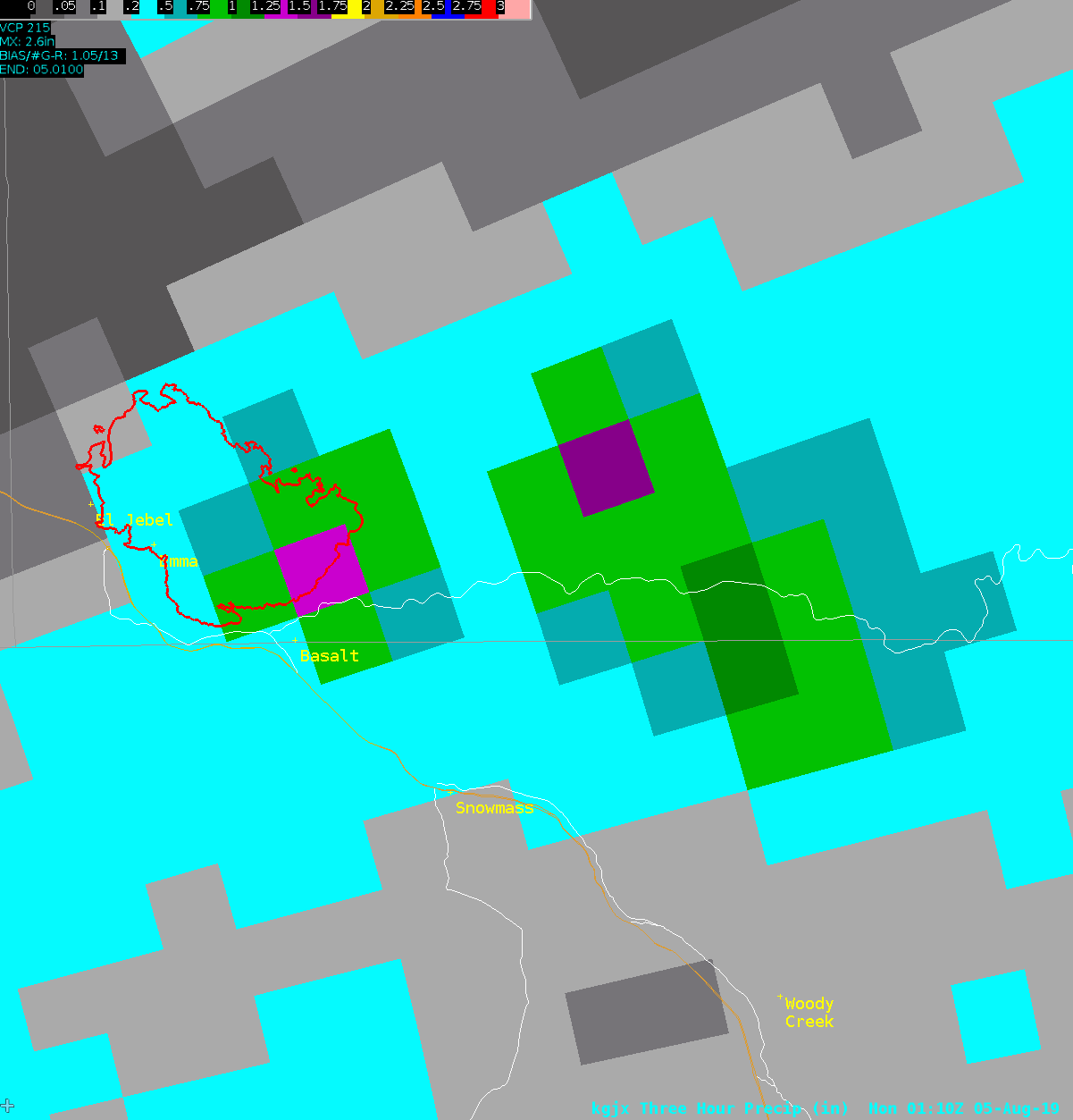 |
| KGJX Storm Total Accumulation (Estimate) | KGJX Storm Total Precipitation (Estimate) | KGJX Max One Hour Precipitation (Estimate) | KGJX Man Three Hour Precipitation (Estimate) |
Rain Reports
PUBLIC INFORMATION STATEMENT
NATIONAL WEATHER SERVICE GRAND JUNCTION CO
1051 AM MDT MON AUG 5 2019

MONSOON MOISTURE PRODUCED SCATTERED TO NUMEROUS SHOWERS AND THUNDERSTORMS
ACROSS EASTERN UTAH AND WESTERN COLORADO. THESE STORMS PRODUCED HEAVY RAIN
WHICH RESULTED IN SIGNIFICANT FLOODING AND DEBRIS FLOWS ON THE LAKE
CHRISTINE FIRE BURN SCAR NEAR BASALT, COLORADO.

...PRECIPITATION REPORTS...

LOCATION                     AMOUNT    TIME/DATE       PROVIDER
EDWARDS 0.5 E                1.23 IN   0700 AM 08/05   COCORAHS
PAGOSA SPRINGS 5.8 SSE       1.20 IN   0700 AM 08/05   COCORAHS
BASALT 5.8E                  0.92 IN   0700 AM 08/05   COCORAHS
REDSTONE 4.9 N               0.85 IN   0800 AM 08/05   COCORAHS
DURANGO 4.8WSW               0.83 IN   0700 AM 08/05   COCORAHS
HESPERUS 4.9SE               0.74 IN   0700 AM 08/05   COCORAHS
AVON 1.1SE                   0.72 IN   0900 AM 08/05   COCORAHS
STEAMBOAT SPRINGS 0.7ESE     0.63 IN   0700 AM 08/05   COCORAHS
PAGOSA SPRINGS 15.0SSE       0.54 IN   0700 AM 08/05   COCORAHS
REDSTONE 1.2 SW              0.52 IN   0800 AM 08/05   COCORAHS
STEAMBOAT SPRINGS 0.6NNW     0.52 IN   0700 AM 08/05   COCORAHS
OAK CREEK 0.4 W              0.52 IN   0630 AM 08/05   COCORAHS
MANCOS 3WNW                  0.50 IN   0700 AM 08/05   COCORAHS
STEAMBOAT SPRINGS            0.47 IN   0730 AM 08/05   COOP
REDVALE 22.8SW               0.41 IN   0800 AM 08/05   COCORAHS
HESPERUS 9.8SW               0.40 IN   0700 AM 08/05   COCORAHS
REDMESA 4.2NW                0.36 IN   0800 AM 08/05   COCORAHS
STEAMBOAT SPRINGS 1.2SSE     0.33 IN   0800 AM 08/05   COCORAHS
SILT 9.6S                    0.33 IN   0700 AM 08/05   COCORAHS
EL JEBEL 0.2 ENE             0.33 IN   0700 AM 08/05   COCORAHS
VAIL 2.6E                    0.33 IN   0700 AM 08/05   COCORAHS
CRESTED BUTTE 6.2N           0.32 IN   0700 AM 08/05   COCORAHS
STEAMBOAT SPRINGS 1.5WNW     0.28 IN   0700 AM 08/05   COCORAHS
VAIL 0.9WNW                  0.27 IN   0700 AM 08/05   COCORAHS
RIFLE 8.9 NE                 0.26 IN   0700 AM 08/05   COCORAHS
DURANGO SPOTTER              0.25 IN   0800 AM 08/05   UCOOP
GUNNISON 6.6N                0.25 IN   0700 AM 08/05   COCORAHS
EDWARDS 1.3WNW               0.21 IN   0700 AM 08/05   COCORAHS
CARBONDALE 0.5W              0.21 IN   0615 AM 08/05   COCORAHS
RIFLE 3.2ENE                 0.20 IN   0700 AM 08/05   COCORAHS
STEAMBOAT SPRINGS 2.0ESE     0.19 IN   0700 AM 08/05   COCORAHS
GLADE PARK 1.4NW             0.19 IN   0700 AM 08/05   COCORAHS
CARBONDALE 0.7 NNW           0.19 IN   0700 AM 08/05   COCORAHS
SLICK ROCK 1.3N              0.19 IN   0630 AM 08/05   COCORAHS
CARBONDALE 5.7E              0.19 IN   0600 AM 08/05   COCORAHS
OAK CREEK 4.7 E              0.16 IN   0700 AM 08/05   COCORAHS
RIDGWAY 4.1 W                0.15 IN   0700 AM 08/05   COCORAHS
GRAND JUNCTION 8NNW          0.15 IN   0700 AM 08/05   COCORAHS
OURAY 0.1 SE                 0.15 IN   1000 PM 08/04   COCORAHS
CARBONDALE 4.6NNE            0.14 IN   0700 AM 08/05   COCORAHS
ALTENBERN, DEBEQUE 15SE      0.13 IN   0700 PM 08/04   COOP
CEDAREDGE 10.5NNW            0.13 IN   0800 AM 08/05   COCORAHS
OURAY 0.23NNW                0.13 IN   0628 AM 08/05   COCORAHS
MONTROSE 6.3 WSW             0.12 IN   0821 AM 08/05   COCORAHS
STEAMBOAT SPRINGS 6.1WNW     0.11 IN   0700 AM 08/05   COCORAHS
FRUITA 1NW                   0.11 IN   0700 AM 08/05   COCORAHS
GLENWOOD SPRINGS 7.2S        0.11 IN   0700 AM 08/05   COCORAHS
COLONA 5SW                   0.10 IN   0900 AM 08/05   COCORAHS
CLARK 0.7NW                  0.10 IN   0700 AM 08/05   COCORAHS
POWDERHORN 4.4NNE            0.09 IN   0800 AM 08/05   COCORAHS
SILVERTON                    0.09 IN   0700 AM 08/05   COCORAHS
MEEKER 14.3ESE               0.08 IN   0700 AM 08/05   COCORAHS
GRAND JUNCTION 3.9WSW        0.08 IN   0700 AM 08/05   COCORAHS
GRAND JUNCTION 5.5SW         0.08 IN   0700 AM 08/05   COCORAHS
GLENWOOD SPRINGS 5.0 SSE     0.08 IN   0700 AM 08/05   COCORAHS
GLENWOOD SPGS 0.64S          0.08 IN   0700 AM 08/05   COCORAHS
GLENWOOD SPRINGS 7.0NW       0.08 IN   0700 AM 08/05   COCORAHS
EAGLE 0.7 NW                 0.08 IN   0657 AM 08/05   COCORAHS
REDLANDS 1E                  0.07 IN   0700 AM 08/05   COCORAHS
DURANGO 0.8SSW               0.07 IN   0700 AM 08/05   COCORAHS
GLENWOOD SPRINGS 5.3SSE      0.07 IN   0700 AM 08/05   COCORAHS
BATTLEMENT MESA 0.8 WSW      0.06 IN   0800 AM 08/05   COCORAHS
FRUITA 4.5NNE                0.06 IN   0700 AM 08/05   COCORAHS
GRAND JUNCTION 1.3 W         0.06 IN   0700 AM 08/05   COCORAHS
LOMA 0.9E                    0.06 IN   0700 AM 08/05   COCORAHS
DOVE CREEK 12.4SSW           0.06 IN   0700 AM 08/05   COCORAHS
REDLANDS 2WNW                0.06 IN   0600 AM 08/05   COCORAHS
STEAMBOAT SPRINGS 7.9WNW     0.05 IN   0800 AM 08/05   COCORAHS
DOYLEVILLE 2.1W              0.05 IN   0730 AM 08/05   COCORAHS
GRAND JUNCTION 1.3 SSW       0.05 IN   0700 AM 08/05   COCORAHS
GLENWOOD SPRINGS 2SSE        0.05 IN   0700 AM 08/05   COCORAHS
GYPSUM 1.9SSW                0.05 IN   0700 AM 08/05   COCORAHS
HOTCHKISS 5.4NE              0.05 IN   0700 AM 08/05   COCORAHS
BAYFIELD 7N                  0.04 IN   0700 AM 08/05   UCOOP
HESPERUS 13.3SSW             0.04 IN   0700 AM 08/05   COCORAHS
GRAND JUNCTION 3.4N          0.04 IN   0600 AM 08/05   COCORAHS
RANGELY                      0.03 IN   0700 AM 08/05   COCORAHS
CORTEZ 5.6NW                 0.03 IN   0700 AM 08/05   COCORAHS
HESPERUS 6.9S                0.03 IN   0700 AM 08/05   COCORAHS
MANCOS 11.3 WNW              0.02 IN   0700 AM 08/05   COCORAHS
DOLORES 4.8ENE               0.02 IN   0700 AM 08/05   COCORAHS
MONTROSE 1.9ESE              0.02 IN   0700 AM 08/05   COCORAHS
MONTROSE 7.3ENE              0.02 IN   0700 AM 08/05   COCORAHS
CRAIG 1.2ESE                 0.02 IN   0700 AM 08/05   COCORAHS
GRAND JUNCTION 5.1ESE        0.02 IN   0700 AM 08/05   COCORAHS
ORCHARD MESA 1.5 NW          0.02 IN   0700 AM 08/05   COCORAHS
FRUITVALE 1W                 0.02 IN   0700 AM 08/05   COCORAHS
DURANGO 2.3 ENE              0.02 IN   0700 AM 08/05   COCORAHS
GYPSUM 2ESE                  0.02 IN   0700 AM 08/05   COCORAHS
CEDAREDGE 1.0NE              0.02 IN   0700 AM 08/05   COCORAHS
HOTCHKISS 7.1WNW             0.02 IN   0700 AM 08/05   COCORAHS
PAONIA 2.1SSE                0.02 IN   0700 AM 08/05   COCORAHS
CHIMNEY ROCK 3N              0.02 IN   0700 AM 08/05   COCORAHS
CRESTED BUTTE COOP           0.01 IN   1000 AM 08/05   COOP
RIO GRANDE RSVR NR.UCN AND C 0.01 IN   1000 AM 08/05   COOP
CANYONLANDS THE NECK         0.01 IN   0800 AM 08/05   COOP
YAMPA 5.1S                   0.01 IN   0700 AM 08/05   COCORAHS
MONTROSE 2.9ESE              0.01 IN   0700 AM 08/05   COCORAHS
GRAND JUNCTION 4.4 E         0.01 IN   0700 AM 08/05   COCORAHS
FRUITVALE 1SW                0.01 IN   0700 AM 08/05   COCORAHS
IGNACIO 2N                   0.01 IN   0700 AM 08/05   COCORAHS
WOLCOTT 2.3N                 0.01 IN   0700 AM 08/05   COCORAHS
CEDAREDGE 1.3 E              0.01 IN   0700 AM 08/05   COCORAHS
LAZEAR 3NW                   0.01 IN   0700 AM 08/05   COCORAHS
MONTROSE 1ESE                0.01 IN   0650 AM 08/05   COCORAHS

OBSERVATIONS ARE COLLECTED FROM A VARIETY OF SOURCES WITH VARYING
EQUIPMENT AND EXPOSURES. WE THANK ALL VOLUNTEER WEATHER OBSERVERS
FOR THEIR DEDICATION. NOT ALL DATA LISTED ARE CONSIDERED OFFICIAL.
 |
Media use of NWS Web News Stories is encouraged! Please acknowledge the NWS as the source of any news information accessed from this site. |
|

