
Scattered thunderstorms with severe gusts, hail and a tornado risk are possible near a cold front from the Ohio Valley to the Mid-Atlantic tonight. Tropical Storm Bertha is expected to bring tropical storm conditions to portions of the Gulf Coast from the panhandle of Florida into Louisiana through Wednesday. Read More >
Grand Junction, CO
Weather Forecast Office
High pressure will remain southeast of the Four Corners the rest of the weekend and continue drawing subtropical monsoon moisture into southern Colorado and Utah. Expect an increase in showers and thunderstorms Sunday with gusty outflow winds, small hail and brief heavy rain possible with storms. The best potential for heavy rain should occur across southeast Utah and southwest Colorado where the better moisture resides and scattered thunderstorms are forecast. Drier air moves back in Sunday evening and will remain through next week. Southwest winds aloft will help keep wildfire smoke out of much of the region, with the exception of extreme northeast Utah and northwest Colorado, where a more westerly component will keep the southern edge of the smoke in this region.
Forecast Weather Chart for Today
.PNG)
Forecast Precipitation Through Sunday
.png)
Today's Forecast High Temperatures

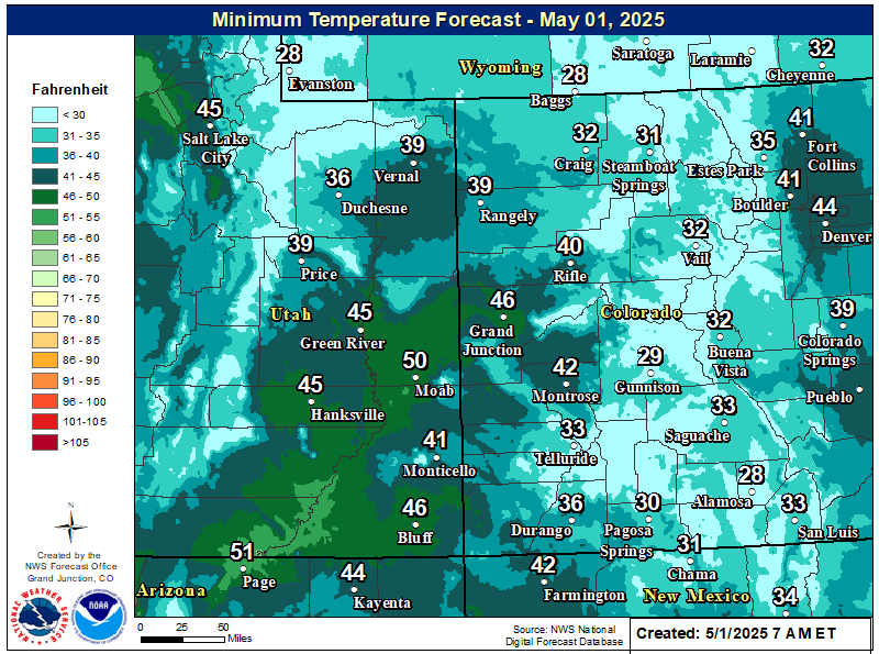
Tonight's Forecast Low Temperatures
Hazards
Detailed Hazards Viewer
National Briefing
Outlooks
Transportation Decision Support
Winter Storm Severity Index
Forecasts
Aviation Weather
Fire Weather
Forecast Discussion
Forecast Points
Local Area
Severe Weather
Soaring Forecast
Winter Weather
Hydrology
Recreational River Report
River Forecast
Weather Safety
Preparedness
NOAA Weather Radio
StormReady
SkyWarn
US Dept of Commerce
National Oceanic and Atmospheric Administration
National Weather Service
Grand Junction, CO
2844 Aviators Way
Grand Junction, CO 81506-8644
970-243-7007
Comments? Questions? Please Contact Us.

