
Flash flooding threatens areas from the Tennessee Valley to the Carolinas as storms repeat along a stalled front. Monsoonal storms may trigger flooding in the Southwest. Dangerous heat expands across the Desert Southwest, Plains, mid-Mississippi Valley and Southern Tier. Critical fire weather for interior Pacific Northwest. Cooler, drier air brings brief relief to the Great Lakes and Northeast. Read More >
Grand Junction, CO
Weather Forecast Office
Valentine's Day Climatology for Eastern Utah and Western Colorado
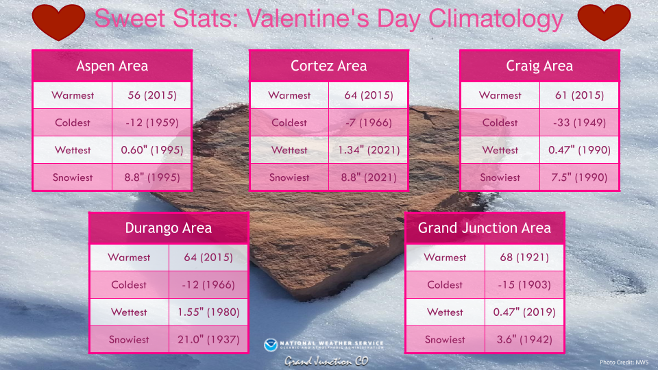
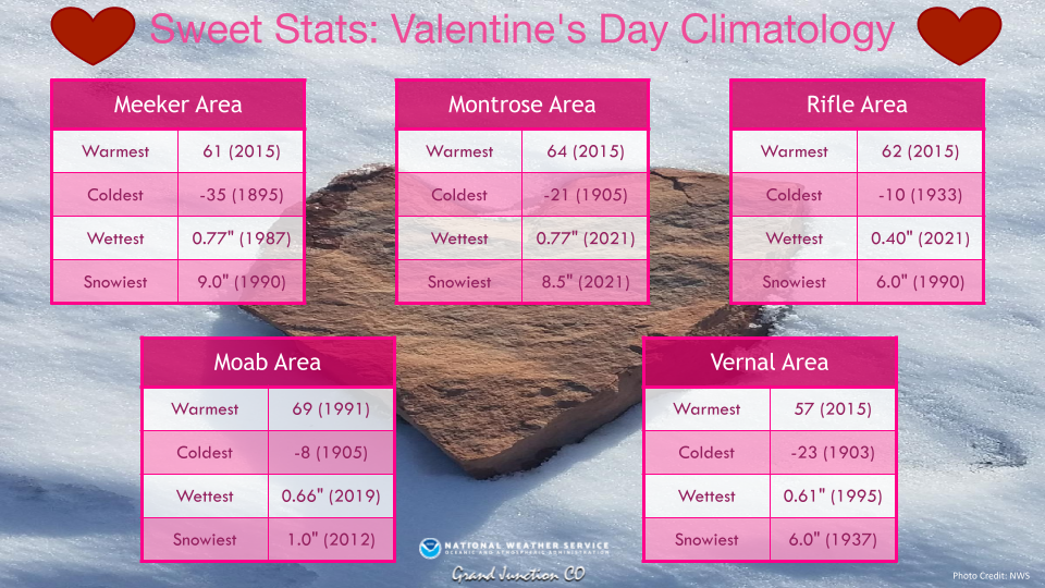
Let's take a look at some "Sweet Stats" (aka Valentine's Day Climatology) for selected cities across eastern Utah and western Colorado. By far the most impressive Valentine's Day took place on February 14, 1937 when an intense snowstorm dropped 21 inches of snow in the Durango area. Another snowy year was 1990 where 9 inches of snow fell in Meeker, 7.5 inches fell in Craig, and 6.0 inches fell in Rifle. The lowest minimum temperature on Valentine's Day was -35 degrees which occurred in the Meeker area in 1895. The warmest temperature of 69 degrees occurred in Moab in 1991.
For more climate information from other sites, please visit our climate page on our website at https://www.weather.gov/wrh/climate?wfo=gjt. You can also follow us on Facebook (@NWSGrandJunction) or Twitter (@nwsgjt).
Hazards
Detailed Hazards Viewer
National Briefing
Outlooks
Transportation Decision Support
Winter Storm Severity Index
Forecasts
Aviation Weather
Fire Weather
Forecast Discussion
Forecast Points
Local Area
Severe Weather
Soaring Forecast
Winter Weather
Hydrology
Recreational River Report
River Forecast
Weather Safety
Preparedness
NOAA Weather Radio
StormReady
SkyWarn
US Dept of Commerce
National Oceanic and Atmospheric Administration
National Weather Service
Grand Junction, CO
2844 Aviators Way
Grand Junction, CO 81506-8644
970-243-7007
Comments? Questions? Please Contact Us.

