
A heat wave over the Southwest will intensify this week, peaking and expanding into the Intermountain West and northern High Plains this weekend. Critical to extremely critical fire weather conditions are forecast from the Northwest and the northern Great Basin this weekend. Particularly Dangerous Situation Red Flag Warnings have been issued. Read More >
Overview
|
A large, prolonged winter storm produced heavy snow across the higher terrain of western Colorado and eastern Utah from November 27-November 29 and led to many lower valley locations seeing their first measurable snowfall of the season! Portions of the northern, central, and southern Colorado mountains received anywhere from 10 to 20 inches with over 2 feet of snow measured in some areas. In addition to snow, an upper level jet measuring 150 kts resided over the area and generated gusty winds, generally for areas south of I-70. These winds created blizzard-like conditions for drivers in the San Juan Mountains early Sunday morning. |
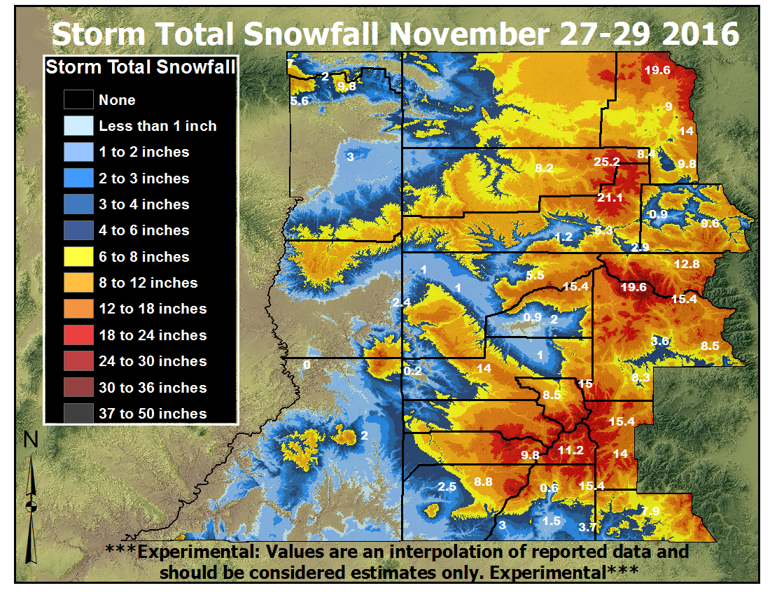 Storm Total Snowfall November 27-29, 2016 |
Snow
Snow began late Saturday night (November 26) as the strong upper level jet moved into the Four Corners Region and brought the first round of precipitation along with it. Heavy snow first hit the San Juan Mountains before upper level flow shifted to the northwest on Sunday afternoon (November 27) where snowfall then favored the northern and central mountains. Another disturbance moved into the area on Monday (November 28) which brought another round of snow to northern and central Colorado, and then yet another wave moved in Monday night. While many breaks occurred over the three-day period, lingering moisture and favorable orographics generated the continuation of showers.
As for the valleys, the first round of snow fell on Monday afternoon. Not much accumulation occurred until a heavier band set up over the Grand Valley Monday night when half an inch to over an inch fell!
Photos & Video:
Snow Across the Area
 |
 |
 |
 |
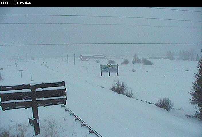
| Heavy Snow Falling in Silverton,CO: 11-27-16 (CDOT) |
Purgatory Ski Area: 11-27-16 (Purgatory Ski Resort) |
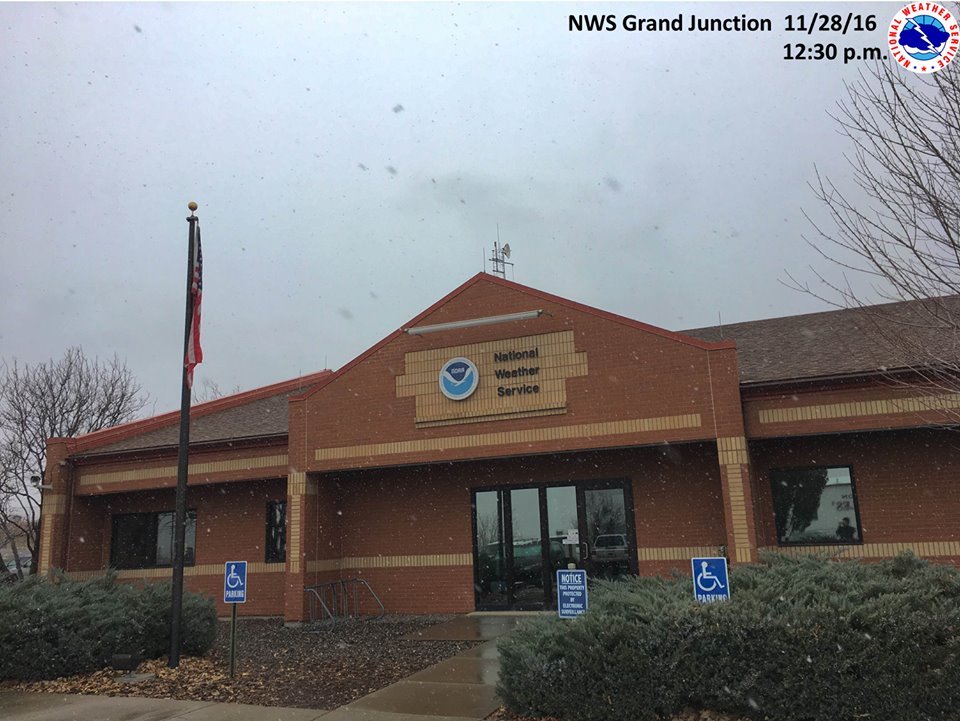
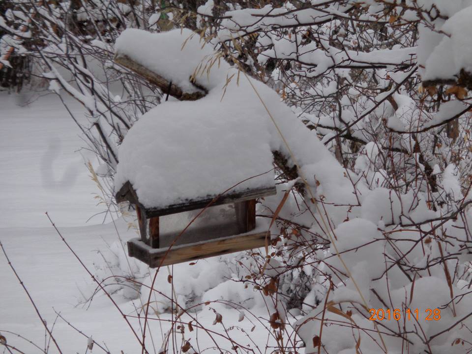
Snow at the Grand Junction NWS Office: 11-28-16 (NWS) |
8 inches fresh snow in Spring Valley: 11-28-16 (Rick Walter) |
Storm Reports
Public Information Statement
National Weather Service Grand Junction CO
114 PM MST Sun Nov 27 2016

Along with the snowfall from this storm, strong winds gusts were observed
at several sites throughout the mountains and some lower elevations.

...Wind Reports...

Location                     Speed     Time/Date       Lat/Lon
2 WSW Red Mtn                97 MPH    0500 AM 11/27   37.88N/107.74W
2 SSW Telluride              74 MPH    0300 AM 11/27   37.90N/107.82W
Kendall Mountain             73 MPH    0500 AM 11/27   37.79N/107.64W
1 ESE Red Mtn                67 MPH    0200 AM 11/27   37.89N/107.68W
9 NNW La Sal                 63 MPH    0200 AM 11/27   38.46N/109.25W
Big Bear Park - 2 ENE Tacoma 58 MPH    0555 AM 11/27   37.50N/107.73W
2 SE Silverton               57 MPH    0200 AM 11/27   37.79N/107.64W
Douglas Pass - 26 N Mack     57 MPH    0630 AM 11/27   39.60N/108.81W
1 WNW Red Mtn                54 MPH    0900 AM 11/27   37.91N/107.73W
4 E Camp Bird                53 MPH    0200 AM 11/27   37.96N/107.65W
Cottonwood Basin - 6 E Escal 51 MPH    0648 AM 11/27   38.57N/108.28W
Pagosa Springs               50 MPH    0500 AM 11/27   37.27N/107.02W
Jay - 3 NNW Hotchkiss        50 MPH    0652 AM 11/27   38.85N/107.74W
3 NW Montrose                49 MPH    0520 AM 11/27   38.51N/107.90W
Montrose Regional Arpt       49 MPH    0520 AM 11/27   38.51N/107.89W
Nucla - Hopkins Field Ap     48 MPH    0535 AM 11/27   38.24N/108.56W
Sunlight Mountain            48 MPH    0852 AM 11/27   39.43N/107.38W
Nucla - Hopkins Field Ap     48 MPH    0535 AM 11/27   38.24N/108.56W
2 NNE Naturita               46 MPH    0255 AM 11/27   38.24N/108.56W
Bryson Canyon - 19 W Mack    46 MPH    0448 AM 11/27   39.28N/109.22W
The Crown - 2 SSW Emma       46 MPH    0749 AM 11/27   39.35N/107.09W
Dead Horse - 13 ENE Buford   46 MPH    0457 AM 11/27   40.08N/107.37W
Huntsman Mesa - 3 NNE Powder 46 MPH    0748 AM 11/27   38.33N/107.09W
Pine Ridge - 6 NW Cameo      46 MPH    0334 AM 11/27   39.24N/108.38W
Stevens Fld Arpt             46 MPH    0555 AM 11/27   37.29N/107.06W
8 NNW Iola                   46 MPH    0819 AM 11/27   38.54N/107.15W
Durango - La Plata Cnty Arpt 45 MPH    0513 AM 11/27   37.14N/107.76W
Craig - Moffat County Arpt   44 MPH    0445 AM 11/27   40.50N/107.52W
Big Indian Valley - 8 ESE La 43 MPH    0520 AM 11/27   38.22N/109.28W
Cortez Municipal Arpt        43 MPH    1024 PM 11/26   37.30N/108.63W
Nucla - 1 NNE Naturita       43 MPH    0258 AM 11/27   38.23N/108.56W
Maeser                       42 MPH    0600 AM 11/27   40.46N/109.57W
Canyonlands Field Arpt       41 MPH    0432 AM 11/27   38.76N/109.75W
Pinto - 18 SE Massadona      41 MPH    0123 AM 11/27   40.02N/108.40W
Telluride Regional Arpt      41 MPH    0615 AM 11/27   37.95N/107.91W
Jacks Canyon - 15 NW Escalan 40 MPH    0550 AM 11/27   38.75N/108.58W
3 WSW Verdure                40 MPH    0500 AM 11/27   37.76N/109.40W

Observations are collected from a variety of sources with varying
equipment and exposures. Not all data listed are considered official.

$$

NWS Grand Junction CO
IRIS System
The following are storm total snow reports from across eastern
Utah and western Colorado.  The period of snowfall ended at the
times noted with each report.  Snow began falling Saturday
night as the large winter storm made its way into the region.

...Snowfall Reports...

Location                     Amount    Time/Date       Elevation (ft.)

...Colorado...

...Archuleta County...
Pagosa Springs 1.6 SSW       7.9 in    0800 AM 11/29   7401
Pagosa Springs 4.2 W         5.8 in    0700 AM 11/29   7640

...Delta County...
Cedaredge 10.5 NNW          28.5 in    0800 AM 11/29  10399
Park Reservoir*             15.4 in    1000 AM 11/29   9960
Skyway 6 ESE                16.5 in    1047 AM 11/29
Paonia 2.1 SSE               2.6 in    0700 AM 11/29   6100
Hotchkiss 5.1 WNW            2.5 in    0700 AM 11/29   6311
Hotchkiss 7.1 WNW            2.6 in    0700 AM 11/29   6600
Hotchkiss 4.7 W              2.0 in    0734 AM 11/29   5735
Ragged Mtn 12 W              2.0 in    1000 AM 11/29   9840
Eckert 1.1 SW                0.9 in    0700 AM 11/29   5485

...Dolores County...
Black Mesa*                 29.4 in    1100 AM 11/29  11580
El Diente Peak*             18.2 in    1000 AM 11/29  10200
Lizard Head Pass*           15.4 in    0200 PM 11/29  10200
Scotch Creek*                9.8 in    0200 PM 11/29   9100
Dove Creek 12.4 SSW          2.0 in    0700 AM 11/29   6604

...Eagle County...
McCoy Park*                  9.6 in    1100 AM 11/29
Vail Mountain*               9.6 in    0100 PM 11/29
Vail 0.9 WNW                 7.1 in    0700 AM 11/29   8172
Basalt 5.8 E                 5.6 in    0700 AM 11/29   7164
Vail 1 SW                    4.0 in    1000 AM 11/29  10300
Eagle-vail 3 WSW             3.0 in    1200 PM 11/29   9480
Tennessee Pass 2 E           3.0 in    1000 AM 11/29  11400
Vail Pass 3 NNW              2.9 in    1200 PM 11/29  10249
El Jebel                     2.9 in    0700 AM 11/29   6427
Gypsum 1.9 SSW               0.9 in    0700 AM 11/29   6531

...Garfield County...
Cattle Creek 4 N             8.0 in    0214 PM 11/28
Vail 0.9 WNW                 7.1 in    0700 AM 11/29   8172
Cattle Creek 3 E             6.7 in    0700 AM 11/29   6521
Cattle Creek 2 WNW           5.5 in    0700 AM 11/29   5942
Glenwood Springs .64 S       5.3 in    0700 AM 11/29   5824
Cattle Creek 3 W             5.3 in    0700 AM 11/29   6914
Carbondale                   3.6 in    0600 AM 11/29   6171
Carbondale 5.7 E             2.9 in    0700 AM 11/29   6427
Rifle 3 ENE                  1.2 in    0700 AM 11/29   5436
Rifle 3.2 ENE                1.2 in    0700 AM 11/29   5472
Wolcott 2.3 N                1.1 in    0700 AM 11/29   7224

...Gunnison County...
Schofield Pass*             29.4 in    0200 PM 11/29  10700
McClure Pass*               25.2 in    1100 AM 11/29   9500
Crested Butte 6.2 N         20.5 in    0700 AM 11/29   9606
Gothic                      20.5 in    0700 AM 11/29   9469
Cimarron 11.2 S             16.0 in    0700 AM 11/29   8356
Somerset 12.5 N             14.8 in    0200 PM 11/30   7047
Marble 0.5 NNW              14.0 in    0700 AM 11/29   8415
Crested Butte               11.3 in    0730 AM 11/29   8860
Pitkin 1.1 SW                8.5 in    0700 AM 11/29   9139
Powderhorn 4 NNE             8.3 in    0800 AM 11/29   9065
Taylor Park                  6.2 in    0600 PM 11/28   9179
Colona 11 E                  5.0 in    0700 AM 11/29
Gunnison 3 WSW               4.5 in    0700 AM 11/29   7602
Gunnison 6.6 N               3.6 in    0700 AM 11/29   7941

...La Plata County...
Vallecito*                  15.4 in    1000 AM 11/29  10880
Kline 4 NW                   5.5 in    1057 AM 11/29
Bayfield 7.0 N               5.0 in    0700 AM 11/29   8200
Rockwood 7 N                 4.7 in    0700 AM 11/29
Arboles 5 WNW                4.0 in    0700 AM 11/29   6545
Ignacio                      3.7 in    0700 AM 11/29   6562
Redmesa 3 WNW                3.0 in    0700 AM 11/29
Redmesa 4.2 NW               3.0 in    0730 AM 11/29   6771
Durango 4.8 WSW              2.7 in    0700 AM 11/29   7430
Falfa 2 SW                   1.5 in    0700 AM 11/29   6795
Durango 0.8 SSW              1.4 in    0700 AM 11/29   6624
Durango 7.1 N                0.6 in    0800 AM 11/29   6575

...Mesa County...
Skyway 3 E                  14.1 in    1200 PM 11/29  10628
Collbran                     6.5 in    0800 AM 11/29   5987
Collbran 4.6 SSE             6.0 in    0700 AM 11/29   7044
Collbran 0.2 ESE             5.5 in    0700 AM 11/29   6043
Plateau City 3 E             4.5 in    0700 AM 11/29
Collbran                     4.1 in    0700 AM 11/29
Glade Park 17 W              2.4 in    0800 AM 11/29   6385
Redlands                     2.0 in    1236 AM 11/29   4624
Grand Junction 4.0 W         2.0 in    0700 AM 11/29   4630
Grand Junction 0.6 WSW       1.5 in    0800 AM 11/29   4627
Grand Junction 4.1 W         1.4 in    0700 AM 11/29   4630
Redlands                     1.4 in    1235 AM 11/29   4632
East Junction Ham            1.0 in    0700 AM 11/29   4625
Redlands 1 E                 1.0 in    0700 AM 11/29   4653
Grand Junction Ham           1.0 in    0700 AM 11/29   4715
Fruita 1.1 NNW               1.0 in    0700 AM 11/29   4517
Wfo Grand Junction           0.4 in    1200 AM 11/29   4832

...Montezuma County...
Mancos 4 WNW                 9.0 in    0700 AM 11/29
Dolores 4.8 ENE              8.8 in    0700 AM 11/29
Cortez 11nw                  2.5 in    0700 AM 11/29   6598
Cortez 1.2 SW                2.3 in    0700 AM 11/29   6165
Cortez                       2.1 in    0800 AM 11/29   6189


...Montrose County...
Columbine Pass*             14.0 in    0200 PM 11/27
Colona 6 NW                  4.0 in    0700 AM 11/29
Montrose 2.9 ESE             3.5 in    0700 AM 11/29   6043
Montrose 2 E                 2.5 in    0700 AM 11/29   5806
Montrose 1.2 ESE             2.4 in    0700 AM 11/29   5830
Montrose 5.6 SW              1.8 in    0800 AM 11/29   6392
Montrose 4.0 NW              1.0 in    0800 AM 11/29   5729
Escalante Forks 11 S         1.0 in    0900 AM 11/29   9400
Paradox                      0.2 in    0600 AM 11/29   5594

...Ouray County...
Red Mountain Pass           21.0 in    0800 AM 11/29  11200
Camp Bird 4 E               20.0 in    0800 AM 11/29   9438
Ouray                       14.9 in    0724 AM 11/29   7728
Ouray Spotter               14.9 in    0724 AM 11/29   7727
Ouray                       10.0 in    0900 AM 11/29   7801
Ridgway 3 NNW                8.5 in    0700 AM 11/29
Red Mtn 2 NE                 7.0 in    1000 AM 11/29   9800
Ridgway 3 NNW                5.5 in    0700 AM 11/29
Red Mtn                      1.3 in    1200 PM 11/29  11050
Camp Bird 3 E                1.1 in    1200 PM 11/29   9543

...Pitkin County...
Independence Pass*          14.4 in    0100 PM 11/29  10600
Mt Massive 8 NW* (Ivanhoe)  12.8 in    1100 AM 11/29  10400
Meridith 6 ESE* (Kiln)      11.2 in    1200 PM 11/29   9600

...Rio Blanco County...
Buford 17 ENE* (Ripple Crk) 25.2 in    1200 PM 11/29  10340

...Routt County...
Steamboat Springs 9 ENE     19.5 in    0652 PM 11/28
Rabbit Ears Pass*           14.0 in    1200 PM 11/29   9400
Steamboat Springs 1.9 E     10.1 in    0600 AM 11/29   7200
Steamboat Springs 1.5 WNW    9.5 in    0700 AM 11/29   6778
Steamboat Springs            9.0 in    0730 AM 11/29   6636
28 E Savery Wy - Whiskey Par 9.0 in    1000 AM 11/29   8950
Steamboat Springs 2 N        8.0 in    0700 AM 11/29
Hahns Peak 6 W               7.9 in    1200 PM 11/29   9419
Steamboat Springs 0.7 ESE    7.9 in    0700 AM 11/29   7049
Steamboat Springs 0.1 NNE    7.1 in    0700 AM 11/29   6743
Milner 4 NE                  6.4 in    0800 AM 11/29
Phippsburg 4 ENE             6.3 in    0700 AM 11/29
Steamboat Springs 1.2 SE     5.5 in    0545 AM 11/29   7075
Steamboat Springs 4 NE       5.0 in    1200 PM 11/29   8400
Toponas 4 W                  4.7 in    0700 AM 11/29   8496
Hahns Peak 3 NW              4.0 in    1000 AM 11/29   8700
Mt Zirkel 4 WSW              4.0 in    0800 AM 11/29   9320
Rabbit Ears Pass 6 W         2.0 in    1200 PM 11/29   9400
Yampa 8 SW                   2.0 in    1000 AM 11/29   9080
Toponas 6 E                  2.0 in    0600 AM 11/29   8880


...San Juan County...
Elk Park 7 W* (Cascade #2)  18.2 in    1000 AM 11/29   8920
Elk Park 8 ENE* (Beartown)  19.6 in    1100 AM 11/29  11600
Elk Park 7 WSW* (Cascade)   19.6 in    1200 PM 11/29   8880
Mineral Creek*              16.8 in    1200 PM 11/29  10040
Coal Bank Pass              16.5 in    0800 AM 11/29  10600
Molas Pass                  15.5 in    0800 AM 11/29  10500

...San Miguel County...
7 NE Sawpit                 24.5 in    1120 AM 11/29   9461
Lone Cone*                  22.4 in    0500 PM 11/29   9600

...Utah...

...Daggett County...
8 SSW Mckinnon               2.0 in    1200 PM 11/29   9145

...Grand County...
35 W Mack                    2.0 in    1000 AM 11/29   8301

...San Juan County...
9 E Grand Cnty Arpt          5.0 in    1200 PM 11/29   9560
7 WNW Verdure                2.0 in    1200 PM 11/29   8968
Monticello No. 2             2.0 in    0700 AM 11/29   7083
9 E Grand Cnty Arpt          1.0 in    1000 AM 11/29   8825

...Uintah County...
19 S Naples                  2.8 in    0110 PM 11/29   5148
16 N Maeser                  1.0 in    1200 PM 11/29   8724
9 NNE Whiterocks             1.0 in    1000 AM 11/29   9510

Observations are collected from a variety of sources with varying
equipment and exposures. Not all data listed are considered official.

*These are estimated snow amounts based off of automated SNOTEL sensors. A 14:1 snow to water equivalence was used for these amounts.

$$

NWS Grand Junction CO
IRIS System
 |
Media use of NWS Web News Stories is encouraged! Please acknowledge the NWS as the source of any news information accessed from this site. |
|

