
Dangerous and extreme heat will remain across portions of the central U.S. this week, persisting across the mid to lower Mississippi Valley, Gulf Coast, southern Plains and portions of Texas. A heat wave over the Southwest U.S. will peak this weekend. Heavy to excessive rainfall may produce flash flooding from the Delmarva Peninsula north into the Hudson Valley today and tonight. Read More >
Dew and Frost occur due to radiational cooling. Radiational cooling happens at night when outside objects release heat into the atmosphere cooling the object. At the same time, the atmosphere radiates heat back into the object. On a clear, calm night, however, the amount of heat lost from the object tends to exceed the heat gained from the atmosphere and the object becomes cooler than the surrounding air.
With sufficient cooling, the air adjacent to the object can cool to its dew point temperature (a measure of the water vapor content present in the air) and become saturated. If the air temperature is above freezing, dew will form. If the temperature is near or below freezing, frost will develop.
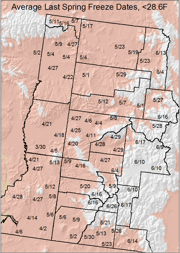
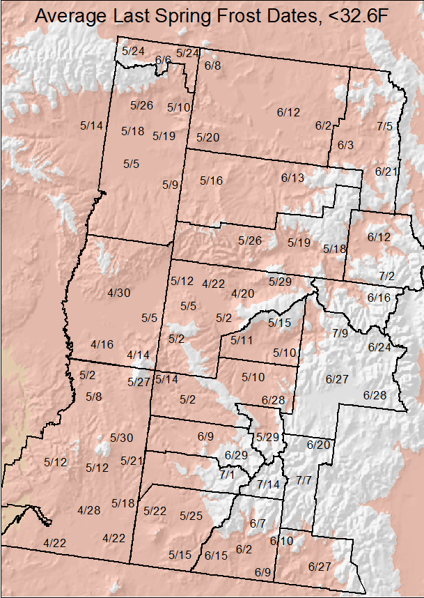
In Colorado and Utah, the terrain varies considerably from high desert to river valleys to the Rocky Mountains. As such, average frost and freeze dates also vary considerably. In fact, frost and freeze dates can differ by as much as 6 weeks. For instance, the average last day of freezing temperatures for Grand Junction is April 22 while for Aspen it is Jun 16. Of course, elevation plays a cruicial role in temperatures as can be seen in the preceding example.
Average Last Freeze/Frost Dates (Colorado):
| Station | Temperature <28.6° F | Temperature <32.6° F | Station | Temperature <28.6° F | Temperature <32.6° F | |
| Aspen |
5/28 |
6/16 |
|
Meeker |
5/29 |
6/13 |
| Cedaredge |
4/29 |
5/15 |
|
Mesa Verde |
5/2 |
5/15 |
| Collbran |
5/9 |
5/29 |
|
Montrose |
4/27 |
5/10 |
|
Cortez |
5/9 |
5/25 |
|
Norwood |
5/20 |
6/9 |
|
Craig |
5/19 |
6/2 |
|
Orch. Mesa |
4/11 |
5/2 |
|
Crested Butte |
6/17 |
7/9 |
|
Ouray |
5/9 |
5/29 |
| Delta |
4/28 |
5/11 |
|
Pagosa Sp |
6/14 |
6/27 |
|
Durango |
5/13 |
6/2 |
|
Palisade |
4/4 |
4/20 |
| Fruita |
4/27 |
5/12 |
Paonia |
4/29 |
5/10 |
|
| Glenwood |
5/1 |
5/18 |
Rangely |
5/1 |
5/16 |
|
| Grand Junction |
4/6 |
4/22 |
Rifle |
5/7 |
5/19 |
|
| Gunnison |
6/10 |
6/27 |
Silverton |
6/26 |
7/14 |
|
| Hayden |
5/23 |
6/3 |
Steamboat |
6/13 |
7/5 |
|
| Ignacio |
5/23 |
6/9 |
Telluride |
6/16 |
6/29 |
|
| Lake City |
6/10 |
6/30 |
Yampa |
6/4 |
6/21 |
|
| Maybell |
5/23 |
6/12 |
Yellow Jacket |
5/6 |
5/22 |
Average Last Freeze/Frost Dates (Utah):
| Station | Temperature <28.6° F | Temperature <32.6° F | Station | Temperature <28.6° F | Temperature <32.6° F | |
| Blanding |
4/27 |
5/12 |
|
La Sal |
5/13 |
5/27 |
| Bluff |
4/14 |
4/28 |
|
Manila |
5/11 |
5/24 |
| Canyonlands |
4/21 |
5/2 |
|
Mexican Hat |
4/6 |
4/22 |
|
Castle Valley |
4/5 |
4/14 |
|
Moab |
3/30 |
4/16 |
|
Cedar Point |
5/8 |
5/21 |
|
Monticello |
5/12 |
5/30 |
|
Dewey |
4/18 |
5/5 |
|
Ouray |
4/27 |
5/5 |
| Dutch John |
5/16 |
6/6 |
|
Roosevelt |
5/2 |
5/14 |
|
Ft Duchesne |
5/4 |
5/18 |
|
Thompson |
4/21 |
4/30 |
| Jensen |
5/4 |
5/19 |
Vernal |
5/9 |
5/26 |
 |
 |

