Sunday:
At some point this fall, winter, or spring, hazardous winter weather will impact the Tri-State Region. Very cold temperatures, high winds, and wintry precipitation are all a given to occur. In an average year, residents of the Tri-State Region can anticipate seasonal snowfall of around 35 inches. In addition, the area will typically observe a few nights with temperatures below zero and at least one night with temperatures below -10 degrees each year.
The main objective of the National Weather Service is to protect you from weather-related hazards. Our office serves customers across northeast Colorado (3 counties), southwest Nebraska (3 counties), and northwest Kansas (13 counties). Many major highways, including Interstate 70, bring thousands of vehicles through the region every day. When winter weather strikes, NWS Goodland works with local emergency managers, school officials, law enforcement and first responders, departments of transportation, the media, and other core partners to keep you safe!
Winter storms, blizzards, dust storms, freezing drizzle, and fog often lead to traffic accidents, stranding motorists and putting lives at risk. This week was made to prepare you for significant winter weather.
How To Interpret Snow Forecasts
There are many different ways to give and say a snow forecast. There are also many sources where you can get a snow forecast. Here is some information on different snow forecasts and what to do with them.
Phrases:
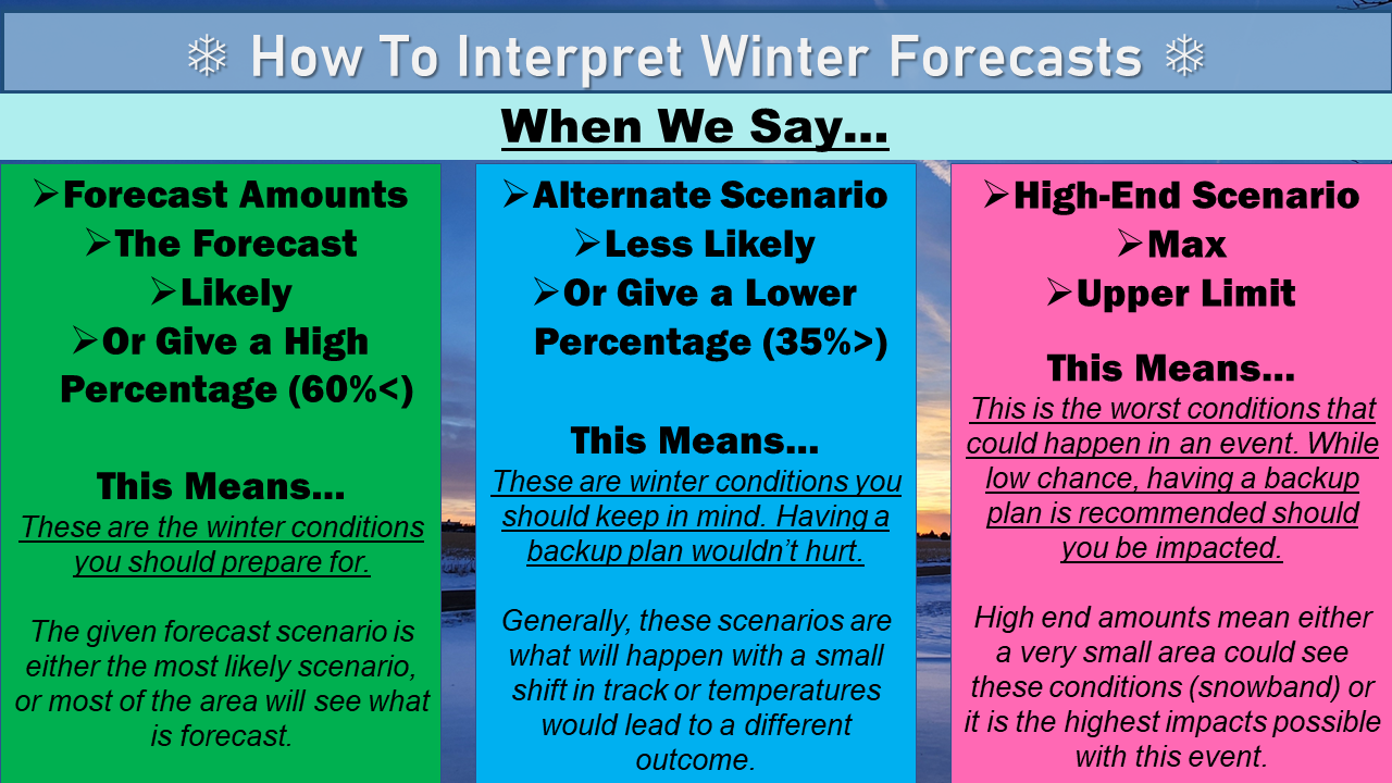
- Forecast Amounts/The Forecast: This is the amount of snow that is forecast by whoever is providing the forecast. The snow amount given is what they think is most likely to happen.
- Likely/High Percentage: Similar to forecast amount, the amount given is what is most likely to occur.
- Alternate Scenario: This is a different snow amount that could occur based on something that is modeled or observed. Small differences in temperature and positioning can alter how much snow is received, so an alternate scenario lists what the change would bring instead.
- High End/Max/Upper Limit: Any of these phrases are used to describe the highest snow total that could occur based on the forecast. This is used to provide people with a worst case scenario, and let them determine if they need to do extra preparation. Often, the provided snow amounts have a low chance of happening or would affect a small part of a given area.
Value Types
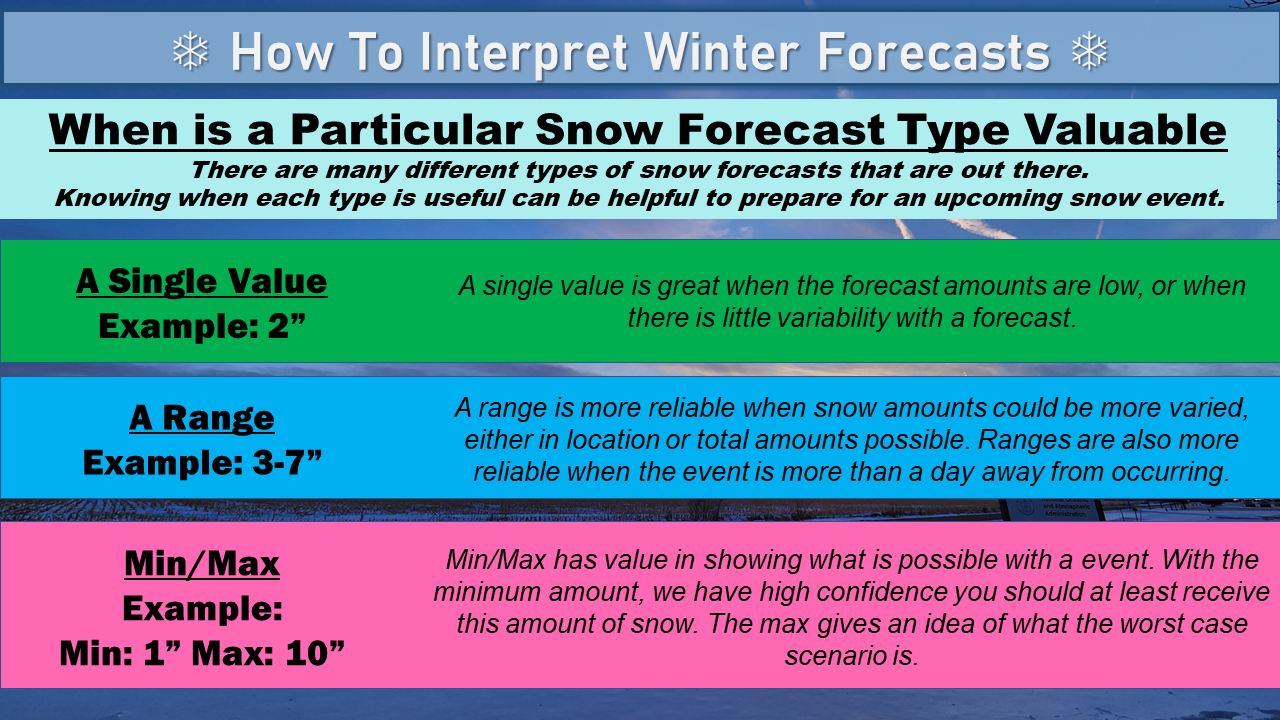
- Single Value: Single value is the most common snow forecast provided by sources. It lists a single value, often the most likely or forecast value. This value is great when snow amounts are low and/or there is low variability. That being said, most scenarios have some variability in either location or amounts, so a single value can be misleading or appear to jump around before the event. In most cases, they don't tell the whole story.
- Range: Ranges are becoming more common as they are a great way to list snow amounts in a way that accounts for variability and can provide more context to the event. For example, a range that starts at 0 inches and goes to 4 inches implies that the snow could miss an area, while a single value of 2 inches would suggest that an area should receive snow.
- Min/Max: Similar to ranges, listing the min and max values is used to provide context. While not as common, those who want to be aware of the possibilities can benefit from know the best and worst case scenario.
____________________________________________________________________________________________________________________________
Sunday's Social Media Posts (click to enlarge)
Monday:
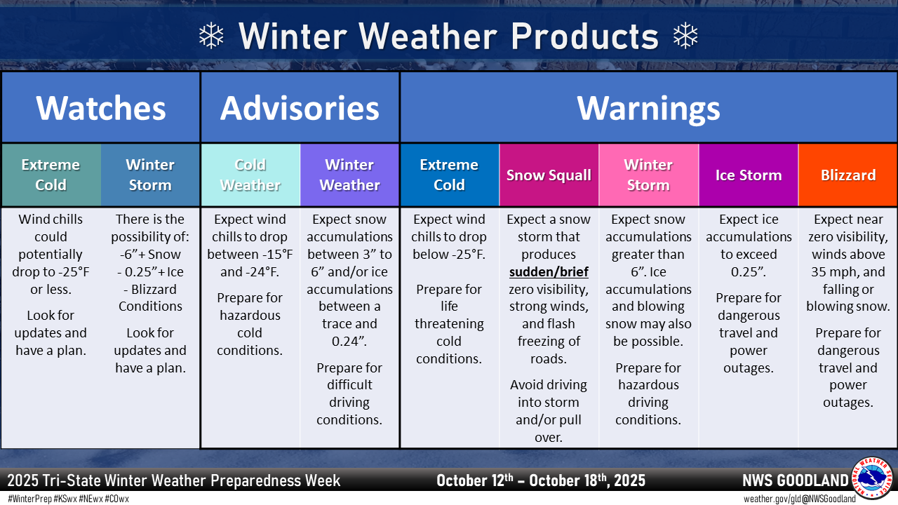
NWS Goodland Products:
In the days leading up to hazardous conditions and throughout a weather event, NWS Goodland will issue watches, warnings, and advisories. Here are the products, including the when and why, that are issued:
Advisories:
An "advisory" signals hazardous weather is occurring, imminent, or has a high probability of occurrence. Advisories are issued up to 48 hours ahead of the event. When an advisory is issued, preparations should be made for weather that is more of a nuisance. Impacts are possible to travel if precautions are not taken.
- Winter Weather Advisory: Issued for winter weather that will cause an inconvenience. Light to moderate snow amounts, sleet, freezing rain, freezing drizzle, and freezing fog will lead to troublesome conditions.
- Cold Weather Advisory: Very cold weather is expected and caution should be exercised. Issued for wind chill readings of -15 degrees to -24 degrees.
- Blowing Dust Advisory: Issued when dust is reducing visibility below one mile but not less than one quarter mile.
- Dense Fog Advisory: Issued when fog is reducing visibility below one quarter mile.
- Freezing Fog Advisory: Issued when fog is not dense (visibility not below one quarter mile), temperatures are below 32 degrees, and the forecaster judges that light icing may become a problem.
Watches:
A "watch" signals the potential for hazardous weather. A watch is issued 12-72 hours ahead of the event, when confidence is high enough. When a watch is issued, preparations should begin for possible high-impact weather.
- Winter Storm Watch: Issued when winter weather could soon be of high impact. This means there is the potential for a blizzard, heavy snow, sleet, freezing rain, or a combination of multiple factors.
- Extreme Cold Watch: Means dangerously cold weather is possible. Issued when wind chill readings may drop below -25 degrees.
- High Wind Watch: Indicates that winds up to and in excess of 58 mph are possible.
Warnings:
A "warning" signals hazardous weather is occurring, imminent, or has a high probability of occurrence. Warnings are issued up to 48 hours ahead of the event. When a warning is issued, preparations for high-impact weather should be completed. Significant impacts, particularly to travel, are likely.
- Blizzard Warning: Issued when blizzard or ground blizzard conditions are expected.
- Winter Storm Warning: Issued when significant winter weather will impact the region. Heavy snow, sleet, or freezing rain are expected.
- Ice Storm Warning: Issued for when an ice storm is expected.
- Extreme Cold Warning: Dangerously cold air is expected. Issued for wind chill readings of -25 degrees or below.
- High Wind Warning: Issued for wind gusts of 58 mph or higher. At times, if blizzard conditions are also anticipated, a high wind warning may not be issued (wind gusts included in blizzard criteria/warning) to keep the messaging more simplistic.
- Dust Storm Warning: Issued when dust is reducing visibility below one quarter mile.
- Snow Squall Warning: Issued when a quick-hitting burst of snow and winds is expected to reduce visibility. They are short-lived and typically last less than 3 hours.
____________________________________________________________________________________________________________________________
Monday's Social Media Posts (click to enlarge)
Tuesday:
A typical High Plains winter will bring a variety of impacts including, but not limited to, dense fog, freezing fog, heavy snow, freezing rain and drizzle, strong winds, blizzard conditions, blowing dust, and dangerously cold temperatures. For today, we will talk about what some of these threats are and the dangers brought about as a result.
Winter Precipitation Types:
There are 4 general precipitation types:
- Snow - precipitation begins as snow well above the Earth's surface. Precipitation remains snow as it falls because the atmosphere remains cold enough to maintain the ice crystals.
- Sleet - precipitation begins as snow well above the Earth's surface. A layer of warm air aloft allows the snow to melt as the flakes fall toward the surface. However, a deep enough layer of cold air beneath the warm air aloft and Earth's surface will cause the water droplets to refreeze into sleet pellets, closely resembling small hail.
- Freezing Rain - precipitation begins as snow well above the Earth's surface. A layer of warm air aloft also allows the snow to melt as the flakes fall toward the surface. However, a shallow layer of cold air near the surface allows the water droplets to cool again, often falling to temperatures below freezing. When the water droplets (rain) strikes the cold surface or an object, the droplets freeze on contact.
- Rain - precipitation begins as snow well above the Earth's surface. Warm air aloft causes the snow flakes to melt as they fall, resulting in droplets of water. The air remains warm enough on the droplet's path to the ground that precipitation remains in the form of rain.
There are two other general precipitation types to be aware of when it comes to winter weather:
- Drizzle - air near Earth's surface becomes saturated, allowing microscopic drops of water to form and fall to the ground.
- Freezing Drizzle - air near Earth's surface becomes saturated, allowing microscopic drops of water to form and fall to the ground. However, with temperatures below freezing, the water droplets will freeze on contact.
High Winds:
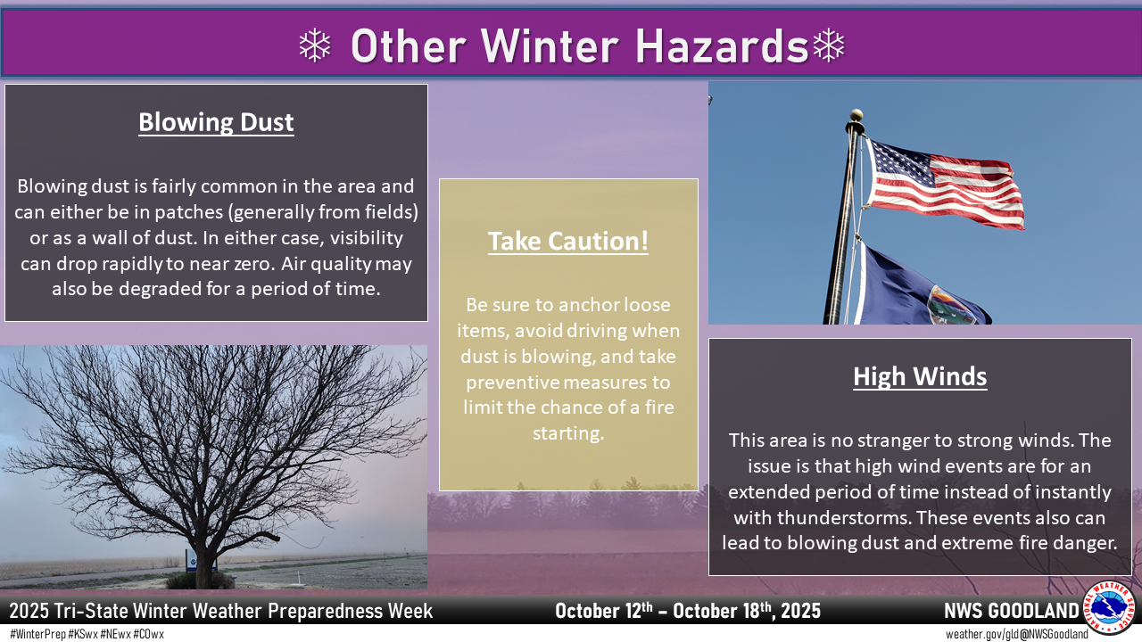
Mid and upper level winds over the Tri-State Region are much stronger in the winter than in the warm season because of the huge difference in temperature from north to south across North America. Under certain meteorological conditions, those winds can reach the surface in the form of strong wind gusts. Dangers from high winds include flying debris, reduced visibility due to blowing dust and blowing snow, damaged or destroyed structures, downed power lines, and overturned vehicles.
If high winds are forecast for your area, you should bring lightweight objects indoors, tie them down outdoors, or move them so they do not become dangerous missiles. Any downed power lines should not be approached. Instead, call the utility company. Stay clear from buildings under construction during high winds as they can easily collapse. Traveling on roads where the strong winds are perpendicular to the road during a high wind episode can be dangerous. If you drive a lightweight or high profile vehicle, you may want to wait until the high winds die down.
Blowing Dust:
Blowing dust is caused by high winds lifting particles of dust, sand, and other small debris into the air. Blowing dust typically becomes a problem in the winter months when many agricultural fields are bare and exposed. Across the Tri-State Region, blowing dust is actually the leading cause of weather-related fatalities. This is due to the reduced visibility on local highways and Interstate 70, leading to multi-vehicle accidents as unsuspecting motorists drive into the blowing dust.
When blowing dust occurs, restrict travel unless absolutely necessary. Most travel can wait until the winds calm down and dust begins to settle. This typically occurs in the late afternoon or early evening hours. If you see a dense plume of dust, avoid traveling into it. Those with respiratory problems are urged to remain indoors as air quality during blowing dust events is poor.
If you find yourself engulfed by a plume of dust while you are driving, here are some steps to keep you safe:
- Pull off the road as far as possible, stop, and turn off your lights.
- Set the emergency brake and keep your seatbelt fastened.
- Be sure the tail lights are NOT illuminated (you don't want people to mistake you for being on the road and hit the back of your vehicle).
Blizzards:
One of the more dangerous weather phenomena to strike the High Plains during the winter months is the blizzard. So what is a blizzard? The following criteria must be met for a winter storm to be considered a blizzard:
- Considerable falling and/or blowing snow.
- Sustained or frequent gusts to 35 mph or greater are observed.
- Visibility is reduced below one quarter of a mile.
- Conditions must occur for at least 3 hours.
Notice that the definition of a blizzard does not include an amount of snowfall required. Snow does not necessarily need to be falling to create blowing snow. Similar to blowing dust, snow on the ground can be lofted into the air, therefore causing the blowing snow which reduces visibility to near zero.
Snow drifts up to five feet high can be another significant hazard to us, traveling vehicles, and our animals. Vehicles that become stuck in snow drifts may be there for a few days as emergency personnel may have the same difficulty getting around. Travel during a blizzard is strongly discouraged. If you absolutely must travel, use extreme caution and do not drive around barricades. The road is blocked off for a reason and the barricade is there for your safety and the safety of our emergency response personnel (emergency managers, law enforcement, fire, EMS, national guard, etc.).
____________________________________________________________________________________________________________________________
Tuesday's Social Media Posts (click to enlarge)
Wednesday:
Extremely cold air from Canada and the Arctic Circle comes south every winter, affecting millions of people across the United States. It is not a question of if this bitterly cold air will make an appearance but when it will make an appearance. Arctic air combined with brisk winds can lead to dangerous conditions, not only for you and your family, but for animals as well.
Extreme Cold Safety:
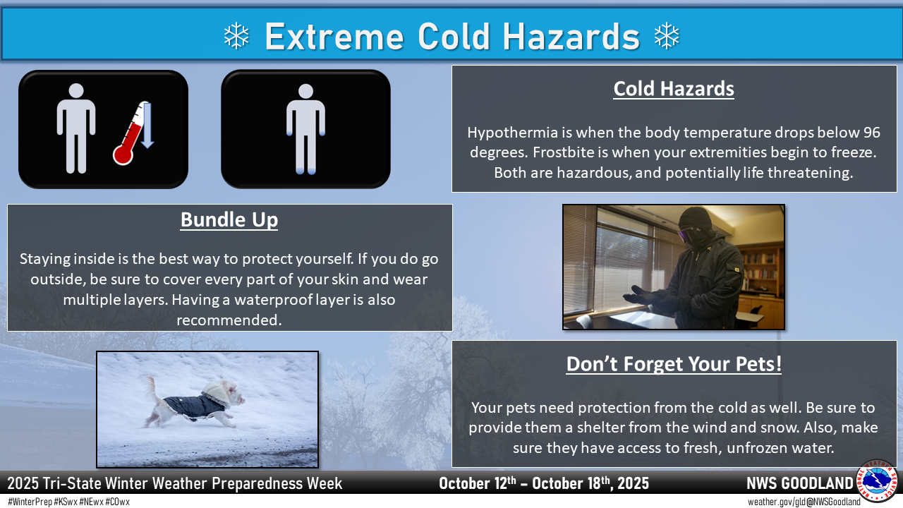
The wind chill temperature helps you determine when dangerous conditions develop that could lead to frostbite or hypothermia. It takes into account heat loss from the human body to its surroundings during cold and windy weather. The calculation utilizes wind speed in miles per hour and temperature in degrees Fahrenheit. For example, a temperature of minus 5 degrees occurring with a 20 mph wind gives a wind chill near minus 30 degrees. This means that your body will lose heat at the same rate as it would if the air temperature were minus 30 degrees with no wind. Wind chill values near minus 25 degrees mean that frostbite is possible within 15 minutes.
Frostbite is the freezing of skin and the body tissue just beneath it. It first affects exposed body tissue where blood circulation may be limited such as your fingers, toes, nose and ears. To minimize frostbite, make sure all body parts are well covered. When frostbite starts, feeling is lost in the affected area and the frozen tissue will take on a white or pale appearance. If you suspect you are experiencing frostbite, hold the frostbitten area closely against warm skin to return blood flow and warmth to the affected area.
Hypothermia is a dangerously low body temperature and is the most common winter weather killer. When you hear of a hiker, climber, hunter or stranded traveler perishing from cold weather exposure, hypothermia was the cause. Most people are surprised to learn that hypothermia deaths can occur with temperatures as warm as 60 degrees. If you or your clothing is wet, then hypothermia becomes even more likely.
Warning signs of hypothermia include uncontrollable shivering, memory loss, disorientation, slurred speech and drowsiness. Immediate medical attention should be given to victims suspected of suffering from hypothermia. If you are trying to help someone who may have hypothermia, first call an ambulance. Then warm the victim slowly, beginning with the core to prevent cardiac arrest. This can be done with your body heat, warm liquids, dry clothing and blankets.
The National Weather Service will issue wind chill advisories and warnings when a deadly combination of wind and cold air threaten. When cold weather threatens, follow these tips for survival:
- Stay dry: Wet clothing results in much faster heat loss from your body. Wear waterproof insulated boots.
- Stay covered: Wear mittens or gloves and wear a hat. At least half of your body heat is lost if your head is not covered.
- Dress layered: Trapped air between loose fitting clothing helps to insulate.
- Stay informed: Have a portable NOAA weather radio nearby to keep you up-to-date with the latest forecasts and warnings. Use wind chill temperatures to guide you in dressing properly for the outdoors. On very cold days, minimize your exposure to the outdoors if possible.
To learn more about extreme cold and wind chill, visit the National Weather Service internet site: https://www.weather.gov/safety/cold
Animal Safety Tips:
For pets (Source: ASPCA):
- Keep your home humidified and towel dry your pet as soon as he/she comes inside, paying special attention to his/her feet and in-between the toes. Repeatedly coming out of the cold into the dry heat of your home can cause itchy, flaking skin.
- Never shave your dog down to the skin in winter, as a longer coat will provide more warmth.
- After each walk, wash and dry your pet’s feet and stomach to remove ice, salt and chemicals - check for cracks in paw pads or redness between toes.
- Bathe pets as little as possible during cold spells. Washing too often can remove essential oils and increase the chance of developing dry, flaky skin.
- Like coolant, antifreeze is a lethal poison for dogs and cats. Be sure to thoroughly clean up any spills from your vehicle, and consider using products that contain propylene glycol rather than ethylene glycol.
- Pets burn extra energy by trying to stay warm in wintertime. Feeding your pet a little bit more during the cold weather months can provide much-needed calories, and making sure she has plenty of water to drink will help keep her well-hydrated and her skin less dry.
- Make sure your companion animal has a warm place to sleep, off the floor and away from all drafts. A cozy dog or cat bed with a warm blanket or pillow is perfect.
- Remember, if it’s too cold for you, it’s probably too cold for your pet, so keep your animals inside. If left outdoors, pets can freeze, become disoriented, lost, stolen, injured or killed. In addition, don’t leave pets alone in a car during cold weather, as cars can act as refrigerators that hold in the cold and cause animals to freeze to death.
For farm animals (Source: American Veterinary Medical Association):
- Move animals to sheltered areas. Shelter belts, properly laid out and oriented, are better protection for cattle than confining shelters, such as sheds.
- Haul extra feed to nearby feeding areas. Moving equipment and feed during and in the days after the storm may become impossible.
- Have water available. Most animals die from dehydration in winter storms.
- Have a disaster plan and practice it with your animals.
- Assemble an evacuation kit (if needed).
- Have well maintained backup generators and a source of fuel for farming operations.
- Keep a list of the species, number, and locations of your animals near your evacuation supplies and note animals' favorite hiding spots. This will save time if a rescue is needed.
____________________________________________________________________________________________________________________________
Wednesday's Social Media Posts (click to enlarge)
Thursday:
Preparedness is a big part of this campaign. Before winter weather arrives in earnest, it is highly recommended that you prepare your home and vehicle for winter weather.
Home Winter Preparations:
Your primary concerns at home or work during a winter storm are loss of heat, loss of power, loss of telephone and internet service, and a shortage of supplies if storm conditions continue for more than a day. With you in your vehicle, at home, or at work, wherever you may be, you should have available:
- Flashlight and extra batteries
- Battery-powered NOAA Weather Radio and/or a portable radio to receive emergency information
- Extra food and water such as dried fruit, nuts and granola bars, and other food requiring no cooking or refrigeration
- Extra prescription medicine
- Baby items such as diapers and formula
- First-aid supplies
- A sleeping bag or an extra blanket(s) for additional warmth.
- Heating fuel: refuel before you are empty; fuel carriers may not reach you for days after a winter storm
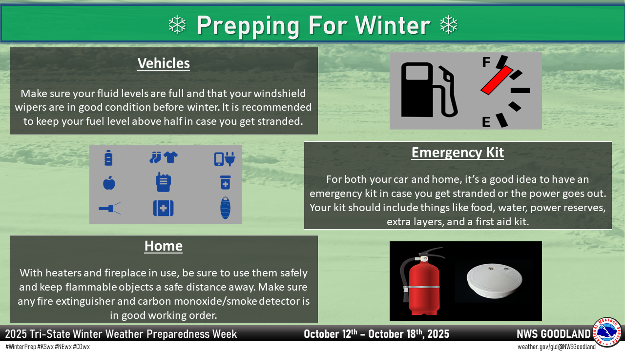
- Emergency heat source: fireplace, wood stove or space heater, properly ventilated to prevent a fire
- Fire extinguisher, smoke alarm; test smoke alarms once a month to ensure they work properly
- Extra pet food and warm shelter for pets
- Cash - in case of power outage to pay for food and other necessities
Here are a few other reminders to keep in mind when preparing for winter weather:
- Review generator safety. You should never run a generator in an enclosed space.
- Make sure your carbon dioxide detector is a working detector. Also make sure the outside vent is clear of leaves and debris. During or after the storm, make sure the outside vent is cleared of snow.
- Home fires are common each winter when trying to stay warm. Review ways to keep your home and loved ones safe.
- For a more complete listing of supplies needed for an emergency kit, visit this Ready.gov site.
Vehicle Winter Preparations:
A well-equipped vehicle possesses a winter survival kit, which includes:
- Mobile phone, charger, batteries
- Blankets/sleeping bags
- Flashlight with extra batteries
- First-aid kit
- Knife
- High-calorie, non-perishable food
- Extra clothing to keep dry
- Large empty can to use as emergency toilet,
- Tissues, napkins, and/or paper towels for sanitary purposes
- Small can and waterproof matches to melt snow for drinking water
- Sack of sand or cat litter for traction
- Shovel
- Windshield scraper and brush
- Tool kit
- Tow rope
- Battery booster cables
- Water container
- Candle and matches to provide light and, in an emergency, lifesaving heat.
- Compass and road maps, don't depend on mobile devices with limited battery life
Other Vehicle Preparations:
- Keep your gas tank near full to avoid ice in the tank and fuel lines and to allow you to run the motor for heat if you get stranded.
- Fully check and winterize your vehicle before the winter season begins.
- Make sure all fluid levels are full and ensure that the lights, heater, and windshield wipers are in proper working condition.
- Don't forget your winter survival kit!
____________________________________________________________________________________________________________________________
Thursday's Social Media Posts (click to enlarge)
Friday:
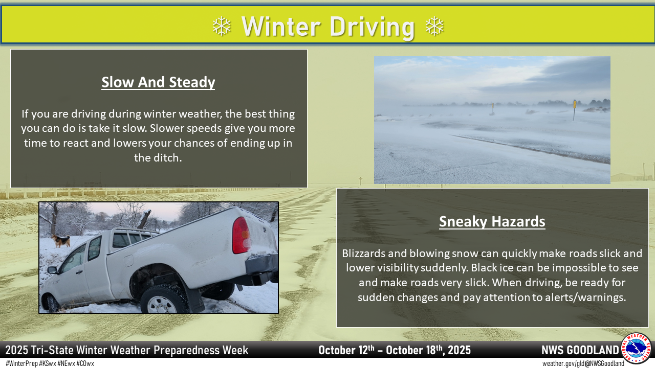
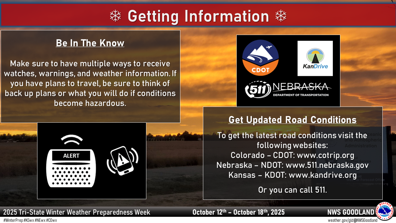
The best way to prevent treacherous winter travel is to avoid it. This can be done by staying informed about the current weather and road conditions as well as the latest weather forecasts. If you absolutely must travel, it is important to become familiar with winter driving tips.
Road Condition Sources:
Colorado:
- Website: www.cotrip.org
- Phone Numbers: toll free number 1-877-315-7623, or you can dial 511
- Social Media: X and Facebook
- Smart Phone Application: "CDOT Mobile"
Kansas:
Nebraska:
Travel Safety Tips:
- Slow down! Even if the roads just look wet they could still be slick. More than 6,000 fatalities occur on the roadways each year due to weather conditions. Visibility will also be reduced, increasing the danger of driving in poor weather conditions.
- Roads which appear to be clear in the winter may actually be coated with a thin layer of ice, commonly known as black ice. This nearly invisible ice layer can cause you to rapidly lose control of your vehicle. Black ice is most common during the nighttime hours. If you sense black ice, you should reduce your speed.
- Do not use cruise control!
- ABSOLUTELY DO NOT DRIVE AROUND BARRIERS! Not only are you risking your life (the road is closed for a reason), but you are risking the lives of the first responders that must come get you.
- Make sure your vehicle is completely clear of ice or snow before starting the trip. Flying snow from cars causes accidents.
- Let someone know where you are going and what route you will take. If something happens, this person will know where to start a search.
- Don't leave the house without a fully charged mobile phone, a car charger, and a emergency supplies kit in your car.
- If you are driving and begin to skid, remain calm, ease your foot off the gas and turn your wheels in the direction you want the front of the car to go. If you have an anti-lock braking system (ABS), apply steady pressure to the brake pedal. Never pump the brakes on an ABS equipped vehicle.
- If you are having trouble seeing due to weather conditions, pull over to the side of the road and stop your car until visibility improves. Turn off your lights and use your parking break when stopped so that another car won't mistakenly follow your tail/brake lights and end up hitting you.
- Persons traveling in light weight or high profile vehicles should avoid travel during strong wind events especially, particularly if the wind direction is perpendicular to the road direction. Stay alert for rapidly changing visibility due to fog, heavy snowfall, blowing snow, and blowing dust.
Follow these winter travel tips and recommendations. They could save your life.
____________________________________________________________________________________________________________________________
Friday's Social Media Posts (click to enlarge)
Saturday:
When caught in a winter storm, there are life saving actions you can take to protect yourself outside, in a vehicle and inside your home or office.
Inside:
If you are at home or work during a winter storm, take the following actions to stay protected:
-
Stay inside
-
When using heat from a fire place, wood stove, space heater, etc., use fire safeguards and properly ventilate.
-
If you have a gas furnace, make sure it is not not blocked by a snowdrift as soon as it's safe to go out.
-
If you have an upstairs gas furnace which vents out the roof, you may need to turn off the upstairs unit until the snow melts off your roof.
-
If your heat goes out:
-
Close off unneeded rooms to avoid wasting heat.
-
Stuff towels or rags in cracks under doors.
-
Close blinds or curtains to keep in some heat.
-
Eat and drink. Food provides the body with energy for producing its own heat. Drinks lots of water and other non-caffeinated, non-alcoholic drinks to prevent dehydration. Cold air is very dry.
-
Wear layers of loose-fitting, lightweight, warm clothing. Remove layers to avoid overheating, perspiration and subsequent chill.
In Vehicles:
If you should become stranded while traveling during a winter storm, here are the actions you should take:
- Stay with your vehicle and do not panic.
- If accompanied by others, take turns sleeping.
- Run the motor every hour for about ten minutes to maintain warmth.
- While running the motor, open the window a little for fresh air to prevent the buildup of carbon monoxide.
- Make sure the exhaust pipe is not blocked to avoid gas poisoning.
- Exercise periodically by vigorously moving arms, legs, toes and fingers.
- Be visible to rescuers
- Tie brightly colored cloths (preferably red) to the side view mirrors, door handles, or external antenna.
- At night, turn on the dome light when running the engine.
- After snow stops falling, raise the hood to indicate you need help.
Outside:
If you should become stranded outside, here are the actions you should take:
- Find shelter. Try to stay dry and cover all exposed body parts.
- When there is no shelter nearby, build a lean-to, windbreak or snow cave for protection from the wind. Build a fire for heat and to attract attention. Place rocks around the fire to absorb and reflect heat.
- Melt snow for drinking water. Eating snow will lower your body temperature.
- Exercise is important! From time to time, move arms, legs, fingers and toes vigorously to keep blood circulating and to keep warm. Avoid overexertion such as shoveling heavy snow, pushing a car or walking in deep snow if you are not in good health. The strain from the cold and the hard labor may cause a heart attack. Sweating could lead to a chill and hypothermia.
After A Winter Storm:
After the storm, let your family and close friends know that you’re okay so they can help spread the word. Register with American Red Cross’s Safe and Well listings. You can use this resource to search missing friends and relatives as well. In the post-winter storm days, be sure to consider the following:
- Stay tuned to your local news for updated information on road conditions and weather forecasts.
- Check with your local water company to ensure water is safe to drink, cook and clean with after a major winter storm.
- Check with utility companies to find out when electricity or gas services may be restored.
- Before you drive your car, take time to ensure your exhaust pipe is clear.
- Brush all the snow off the car so it doesn't fall on your windshield while you are driving or fly onto other cars, causing an accident.
- Leave extra time for blocked, closed or icy roads. Be on the look out for potholes and black ice.
Thank you all for being a part of our Tri-State Winter Weather Preparedness Week! All these efforts help us to build a Weather-Ready Nation...which will make America safer by saving more lives and protecting livelihoods.
We hope you feel more prepared to deal with and enjoy the upcoming winter season!
____________________________________________________________________________________________________________________________
Saturday's Social Media Posts (click to enlarge)
.png)
.PNG)