HOME
FORECAST
Local
Graphical
Aviation
Marine
Rivers and Lakes
Hurricanes
Severe Weather
Fire Weather
Sunrise/Sunset
Long Range Forecasts
Climate Prediction
Space Weather
PAST WEATHER
Past Weather
Astronomical Data
Certified Weather Data
SAFETY
INFORMATION
Wireless Emergency Alerts
Weather-Ready Nation
Brochures
Cooperative Observers
Daily Briefing
Damage/Fatality/Injury Statistics
Forecast Models
GIS Data Portal
NOAA Weather Radio
Publications
SKYWARN Storm Spotters
StormReady
TsunamiReady
Service Change Notices
EDUCATION
NEWS
SEARCH
Search For
NWS
All NOAA
ABOUT
About NWS
Organization
For NWS Employees
National Centers
Careers
Contact Us
Glossary
Social Media
NWS Transformation
Local forecast by
"City, St" or ZIP code
Sorry, the location you searched for was not found. Please try another search.
Multiple locations were found. Please select one of the following:
Location Help
News Headlines
Survey Results from 7/28/2026 Storms
Customize Your
Weather.gov
Enter Your City, ST or ZIP Code
Remember Me
LOADING...
Greenville-Spartanburg, SC
Weather Forecast Office
Regional Weather Conditions
Weather.gov
>
Greenville-Spartanburg, SC
> Regional Weather Conditions
Current Hazards
River Flooding
Briefing Page
Winter
Local Outlook
Space
Drought
Thunderstorms
Hurricanes
Reporting Severe Weather
Current Conditions
Observations (List)
Satellite
Air Quality
Observations (Map)
Rainfall
Hourly Weather
Radar
Charlotte Radar
Local KGSP Standard Radar (low bandwidth)
Regional Standard Radar (low bandwidth)
National Standard Radar (low bandwidth)
Local KGSP Enhanced Radar
Forecasts
Tropical
Aviation
Forecasters' Discussion
Map View
Hourly View
Winter
Fire Weather
Recreational
Rivers and Lakes
Current & Past Streamflow
Ensemble River Guidance
River Observations (Map)
River Forecast Centers
River Forecasts (Map)
Climate and Past Weather
Past Rainfall
CoCoRaHS
24 Hour Summary
Snowfall Records
Past Observed Weather
Drought Outlook
Climate Prediction
Local Climate Page
Historic Western Carolinas & Northeast Georgia Tornadoes
This Date in GSP Weather History
Local Programs
Local Research
Skywarn
NOAA Weather Radio
CoCoRaHS
Education and Outreach
Other Links
Cooperative Observers
WRN Ambassadors
png,/images/gsp/features/feature_Img.png
Regional Weather Conditions
Current Conditions (text):
Hourly observations from area airports over past 24 hours
South Carolina State Weather Roundup
North Carolina State Weather Roundup
Tennessee State Weather Roundup
Georgia State Weather Roundup
Past Temperature and Precipitation Tables:
CoCoRaHS Precipitation Reports from the western Carolinas and northeast Georgia (LCO)
Daily Precipitation Reports from across the area (HYD)
South Carolina State Temperature and Precipitation (RTP)
North Carolina RTP
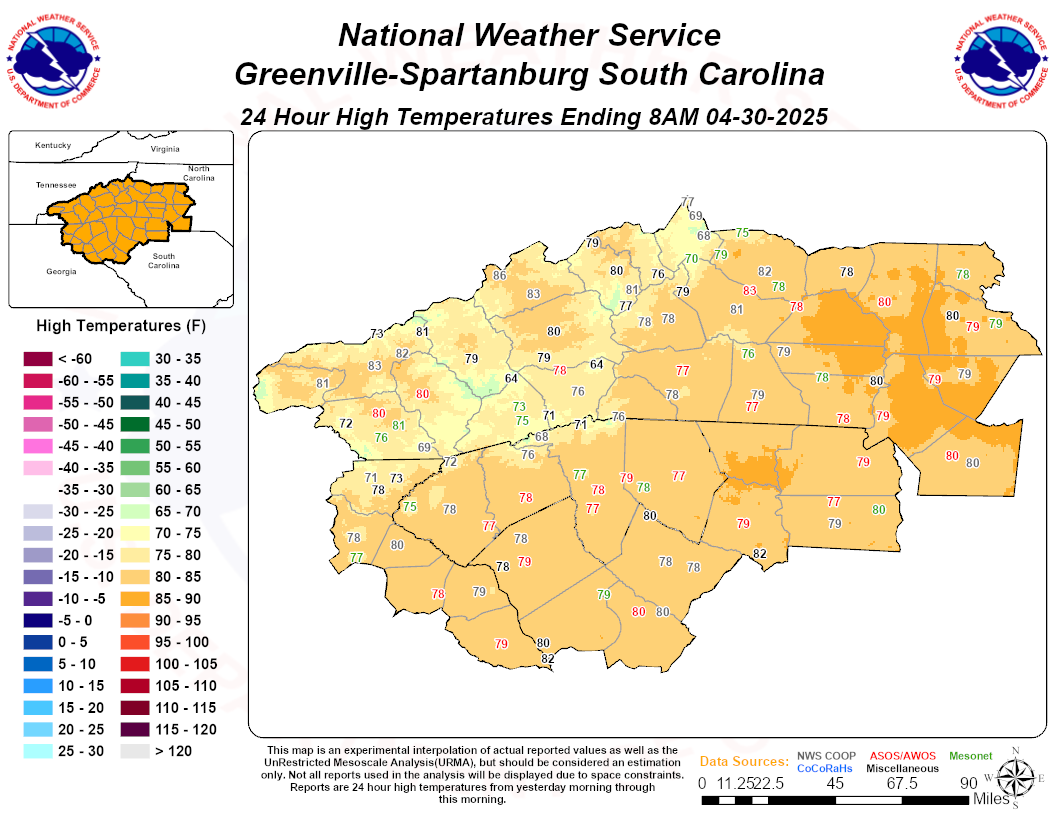
24-Hr High Temperature
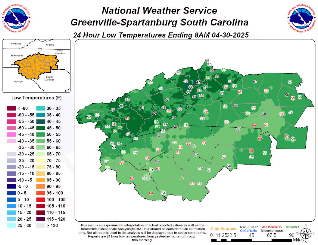
24-Hr Low Temperature
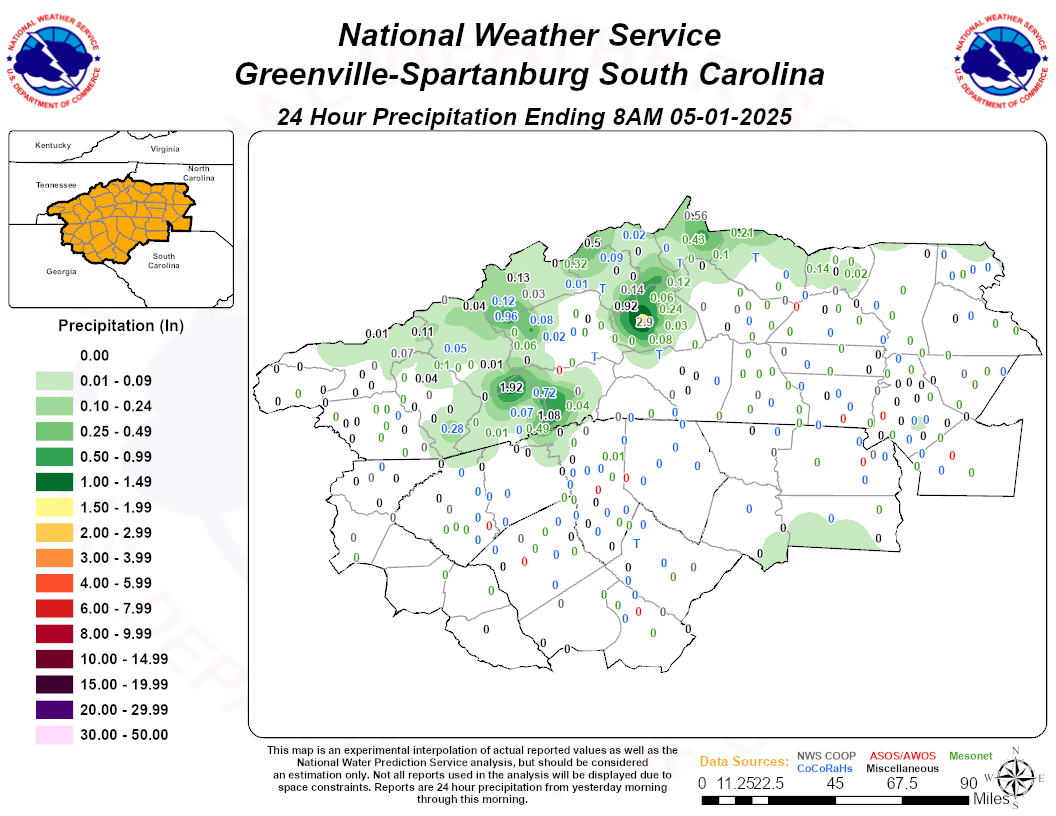
24-Hr Precipitation
Daily Climate, High/Low Temperatures, and Precipitation Maps for the Carolinas and Georgia
Archived High, Low, and Precipitation Maps
Radar
Current Weather
Rivers & Lakes
Satellite
Forecast Maps
Hour by Hour Forecast
Tropical Weather
Graphical Hazards
Weather Hazard Briefing
Report Severe Weather
Fire Weather
Drought
Recreation Forecasts
Obs & Text Products
Forecaster's Discussion
Climate Data
Hourly Weather
NOAA Weather Radio
Follow us on X
Follow us on Facebook
Follow us on YouTube
GSP RSS Feed


 Hourly Weather