|
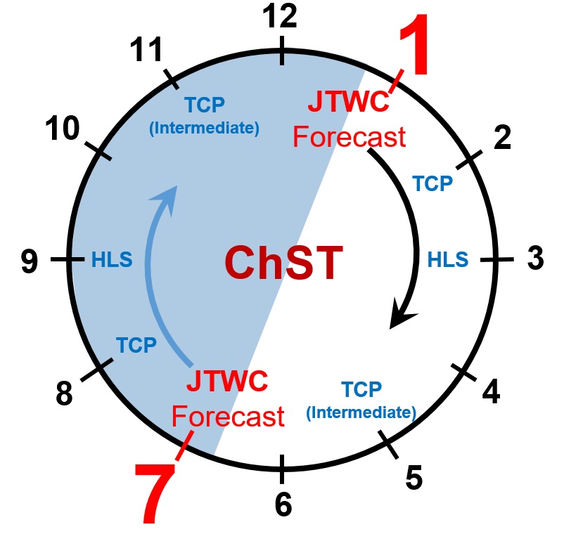
Anytime a tropical cyclone (TC) is in the WFO Guam Area of Responsibility, WFO Guam issues increasing
information regarding the TC(s). At a minimum, Public Advisories are issued every 6 hours, but as TC
watches/warnings are issued for islands (lead times of 48hr/24hr of the arrival of damaging winds (39 mph / 34
kt)), Public Advisories increase to every 3 hours, as well as the 6-hourly issuance of the Local Statements. More
information about our special TC text products is below, as well as a 12-hour clock cycle of our TC operational
schedule.
Public Advisory (TCPPQ#)
- A plain-language interpretation of the JTWC warning bulletin.
- Provides latest information on tropical storm/typhoon watches and warnings.
- Issued at least every 6 hours when a tropical cyclone is expected to affect WFO Guam's Area of Responsibility.
- Issued every 3 hours when TC watches or warnings are in effect for any of WFO Guam’s 39 TC
warning points.
Local Statement (HLSPQ#)
- Specific forecast for each island under a watch or warning, including rain, wind, surf, storm surge and coastal inundation, as well as recommended preparations.
Tropical Cyclone Update (TCUPQ#)
- Hourly radar-based position estimates of a TC when within the range (about 230 miles) of Guam's Doppler radar.
- Issued hourly near the top of the hour when a center position fix is available.
- May also be issued, at any time, for significant changes, notable observations, or notable events
occurring in the development or progress of a TC in the Marianas.
Post-Storm Tropical Cyclone Reports (PSHGUM)
- Brief history of a TC requiring WFO Guam’s issuance of TC watches/warnings.
- Observational data from islands or surrounding marine zones during the TC passage.
- Impacts narratives from each island affected by a passing TC.
|


 Public Forecast
 Marine Forecast
 Radar
Radar Satellite
 Area Forecast Discussion
.png) Active Tropical Cyclones
Active Tropical Cyclones Palau Sector
 Yap Sector
 Marianas Sector
 Chuuk Sector
 Pohnpei/Kosrae Sector
 Marshall Islands Sector