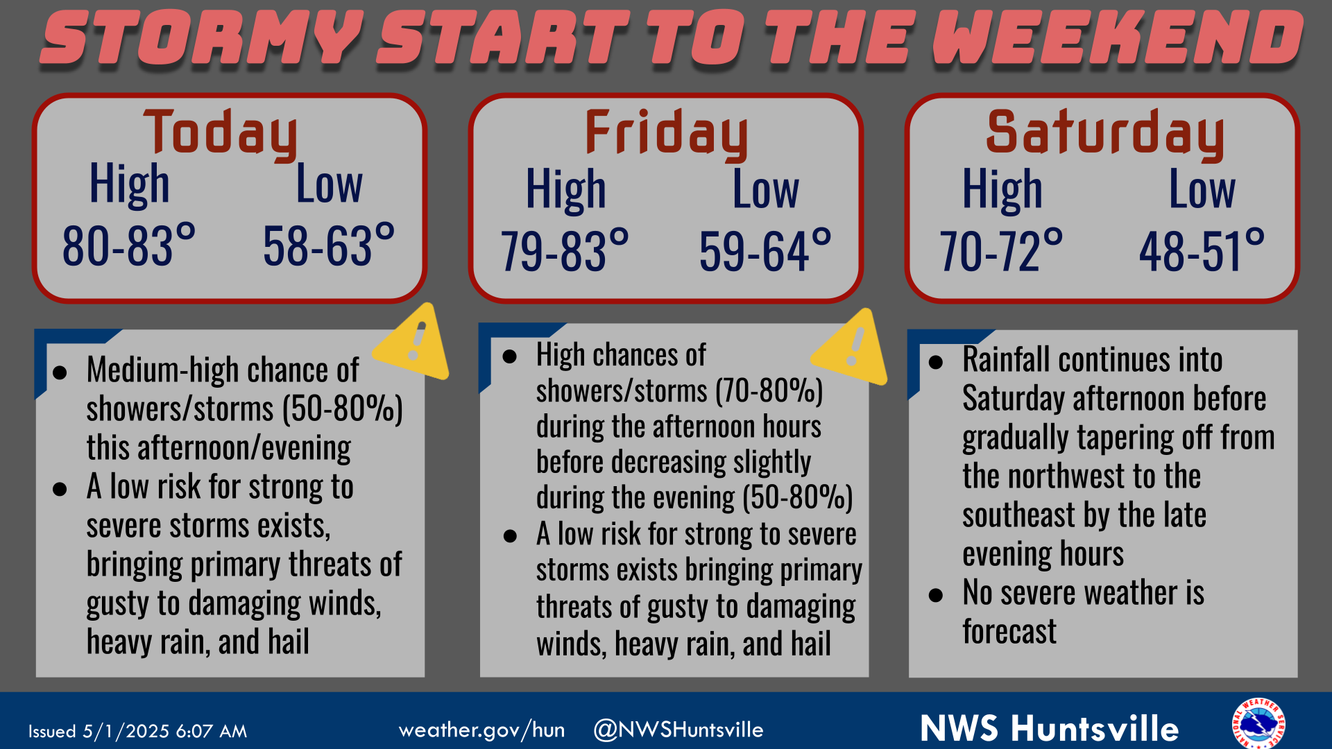
National Weather Service United States Department of Commerce

Severe Thunderstorms in the Ohio and Tennessee Valleys; Flash Flooding Possible in the Southwest

Scattered damaging winds, isolated severe hail, and a brief tornado or two are possible from the Upper Ohio to Tennessee Valleys during the late afternoon and evening. Across the Southwest, monsoonal moisture will continue to bring heavy rain and a threat for isolated to scattered flash flooding through Saturday. Read More >

Click a location below for detailed forecast.

Last Map Update: Sat, Sep 6, 2025 at 12:20:59 am CDT

A line of strong to severe storms is expected to move through the are late tonight into early Saturday morning. The main threats are damaging wind gust, hail, and locally heavy rainfall. With overnight storms make sure you have multiple ways to receive warnings
Low chances for strong to severe storms tomorrow (NW AL) with showers lingering into Saturday. Make sure to remain weather aware if participating in outdoor events! A drier continental airmass will then follow in the wake of a cold front later in the day Saturday, with highs in the upper 70s-lower 80s and lows in the lower-mid 50s early next week.
Low temperatures and precipitation chances for tonight.
High temperatures and precipitation chances for tomorrow.


Location Sky/Weather Temp Dewpt RH Wind Baro Remarks
Huntsville


Muscle Shoals


Decatur


Meridianville


Vinemont


Albertville


Scottsboro


Fort Payne


Winchester


Tullahoma


Fayetteville


Courtland


Note: "N/A" or "MISG" will be displayed if values are not available. In the LOCATION column, click on links for a list of recent observations at sites of interest. In the WIND column, VRB is "variable" and G is "gust". Wind speeds are in MPH. In the BARO (pressure) column, values are in inches. In the REMARKS column, HX is "heat index", WCI is "wind chill index", and VSB is "visibility" (if shown).
Text Product Selector (Selected product opens in a new window)
SITREP GRAPHICAL HWO DISCUSSION FIRE WX AVIATION WX HYDROLOGY
 
AIR QUALITY GRIDDED FORECAST FORECAST (HR) CLIMATE CLIMATE GRAPHS OBSERVATIONS
 
SATELLITE WX RADIOS   STORM SPOTTER TRAINING   PAST EVENTS GIS TORNADO HISTORY
Daily Climate for Middle Tennessee
EDUCATION BEING PREPARED ESTAR PREPARANDO