National Weather Service United States Department of Commerce

Heat Wave in the Eastern US; Heavy Rain in the Ohio Valley

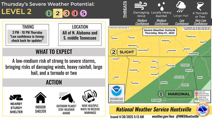
Dangerous, long-lasting heat is expected across portions of the Central and Southeast U.S. Showers and thunderstorms, some severe, may produce heavy rain and localized areas of flash flooding across parts of the Ohio/Tennessee Valleys into the Appalachians. Severe thunderstorms are possible across parts of the northern Great Plains. Fire weather conditions possible in the Great Basin. Read More >

Click a location below for detailed forecast.

Last Map Update: Mon, Jul 21, 2025 at 12:10:34 am CDT

Dangerous heat will be the main theme through much of the week. Expect temperatures to rise into the low to mid 90s with max heat indices between 100-111F by Tuesday/Wednesday. Daily afternoon thunderstorms are possible as well. Make sure to drink plenty of water and don't leave people or pets in cars! Also, when thunder roars, go indoors!
A Heat Advisory is in effect Monday afternoon into the evening hours (11 AM - 8 PM CT) for north central AL, northwest AL, and southern middle TN for high temps in the mid 90s with heat indices reaching 105-107 degrees. Be sure to stay hydrated, limit strenuous outdoor activity, and wear light colored/lightweight clothing.
Strong to severe storms will be possible in NE AL and southern middle TN on Monday afternoon with our main concerns being gusty winds and heavy rainfall. Make sure to check back for updates!
The Climate Prediction Center has outlooked the Tennessee Valley in a Medium Risk (40-60%) for much above normal temperatures late next week. This means temperatures have a medium chance of reaching or exceeding the mid to upper 90s and heat indices between 100-105 degrees during this period. Stay weather aware and up to date with the forecast!
Low temperatures and precipitation chances for tonight.
High temperatures and precipitation chances for tomorrow.
This graphic contains daily climate data (climate normals and records) for today for the sites listed. The legend is in the upper left portion of the image. The current normals period is 1991-2020.


Location Sky/Weather Temp Dewpt RH Wind Baro Remarks
Huntsville


Muscle Shoals


Decatur


Meridianville


Vinemont


Albertville


Scottsboro


Fort Payne


Winchester


Tullahoma


Fayetteville


Courtland


Note: "N/A" or "MISG" will be displayed if values are not available. In the LOCATION column, click on links for a list of recent observations at sites of interest. In the WIND column, VRB is "variable" and G is "gust". Wind speeds are in MPH. In the BARO (pressure) column, values are in inches. In the REMARKS column, HX is "heat index", WCI is "wind chill index", and VSB is "visibility" (if shown).
Text Product Selector (Selected product opens in a new window)
SITREP GRAPHICAL HWO DISCUSSION FIRE WX AVIATION WX HYDROLOGY
 
AIR QUALITY GRIDDED FORECAST FORECAST (HR) CLIMATE CLIMATE GRAPHS OBSERVATIONS
 
SATELLITE WX RADIOS   STORM SPOTTER TRAINING   PAST EVENTS GIS TORNADO HISTORY
Daily Climate for Middle Tennessee
EDUCATION BEING PREPARED ESTAR PREPARANDO