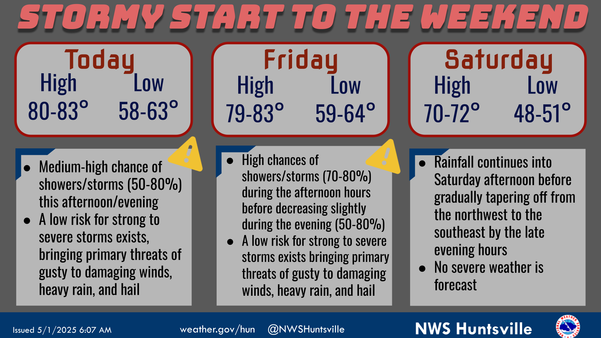
National Weather Service United States Department of Commerce

Severe Thunderstorms in the Northern Plains and Upper Midwest; Critical Fire Weather in the West; Dangerous Heat in the Central and Eastern U.S.

Severe thunderstorms are likely today across the northern Plains and into the upper Mississippi Valley. Gusty winds and dry conditions will result in widespread critical fire weather through Saturday across parts of the Four Corners region and the Great Basin. A significant and dangerous heat wave will expand from the Central U.S. into the Eastern U.S this weekend through much of next week. Read More >

Click a location below for detailed forecast.

Last Map Update: Fri, Jun 20, 2025 at 11:34:37 pm CDT

A Heat Advisory has been issued for portions of NW Alabama on Saturday from 12pm through 7pm. Dangerous heat is forecast with heat index values rising between 101-107 degrees. Make sure you stay hydrated and limit strenuous outdoor activities
Dangerous heat is forecast to build into the Tennessee Valley this weekend and persist through mid next week. Heat Indices expected to reach between 93-107° Saturday through Tuesday with the highest values further west. This will be the first heat wave of the 2025 season, so please remember heat safety! Heat is one of the deadliest weather hazards - don't underestimate it. Never leave people or pets alone in a car. Drink plenty of water, even if you don't feel thirsty. Wear loose-fitting, light-colored clothing. Spend time in air conditioning and in the shade.
Low temperatures and precipitation chances for tonight.
High temperatures and precipitation chances for tomorrow.
This graphic contains daily climate data (climate normals and records) for today for the sites listed. The legend is in the upper left portion of the image. The current normals period is 1991-2020.


Location Sky/Weather Temp Dewpt RH Wind Baro Remarks
Huntsville


Muscle Shoals


Decatur


Meridianville


Vinemont


Albertville


Scottsboro


Fort Payne


Winchester


Tullahoma


Fayetteville


Courtland


Note: "N/A" or "MISG" will be displayed if values are not available. In the LOCATION column, click on links for a list of recent observations at sites of interest. In the WIND column, VRB is "variable" and G is "gust". Wind speeds are in MPH. In the BARO (pressure) column, values are in inches. In the REMARKS column, HX is "heat index", WCI is "wind chill index", and VSB is "visibility" (if shown).
Text Product Selector (Selected product opens in a new window)
SITREP GRAPHICAL HWO DISCUSSION FIRE WX AVIATION WX HYDROLOGY
 
AIR QUALITY GRIDDED FORECAST FORECAST (HR) CLIMATE CLIMATE GRAPHS OBSERVATIONS
 
SATELLITE WX RADIOS   STORM SPOTTER TRAINING   PAST EVENTS GIS TORNADO HISTORY
Daily Climate for Middle Tennessee
EDUCATION BEING PREPARED ESTAR PREPARANDO