National Weather Service United States Department of Commerce

Areas of Severe Thunderstorms and Excessive Rainfall through Memorial Day

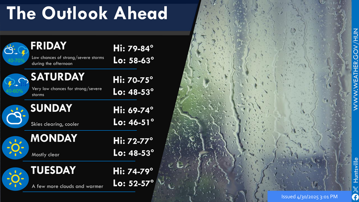
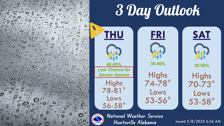
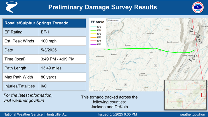
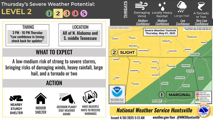
Multiple rounds of thunderstorms are forecast to impact portions of the Southern Plains, Mid-South, and Tennessee Valley through Memorial Day. Severe thunderstorms may produce large hail, severe wind gusts, and a few tornadoes. Excessive rainfall is also likely and may result in scattered to numerous instances of flash flooding. Read More >

A Severe Thunderstorm Watch is in effect for the whole area until 11 PM.
A Enhanced Risk (level 3 out of 5) has been issued for northern AL and southern middle TN. A cluster of storms is expected to move in from the west this afternoon with strong to severe storms capable of producing damaging winds, hail, and locally heavy rainfall. A tornado threat is very low.
Storm surveys thus far have resulted in 13 tornadoes in north Alabama on 5/20/2025. The waterspout on Pickwick lake that moved onshore in Lauderdale County will be evaluated further with drone imagery next week. These results are subject to changes and are preliminary.
Unsettled weather is forecast for the holiday week. There will be daily chances for showers and thunderstorms are forecast each day. Some strong to severe storms are possible on Monday and Tuesday. Rain chances should wind down gradually for the mid and latter half of the week.
Low temperatures and precipitation chances for tonight.
High temperatures and precipitation chances for tomorrow.
This graphic contains daily climate data (climate normals and records) for today for the sites listed. The legend is in the upper left portion of the image. The current normals period is 1991-2020.


Location Sky/Weather Temp Dewpt RH Wind Baro Remarks
Huntsville


Muscle Shoals


Decatur


Meridianville


Vinemont


Scottsboro


Fort Payne


Winchester


Tullahoma


Fayetteville


Courtland


Note: "N/A" or "MISG" will be displayed if values are not available. In the LOCATION column, click on links for a list of recent observations at sites of interest. In the WIND column, VRB is "variable" and G is "gust". Wind speeds are in MPH. In the BARO (pressure) column, values are in inches. In the REMARKS column, HX is "heat index", WCI is "wind chill index", and VSB is "visibility" (if shown).
Text Product Selector (Selected product opens in a new window)
SITREP GRAPHICAL HWO DISCUSSION FIRE WX AVIATION WX HYDROLOGY
 
AIR QUALITY GRIDDED FORECAST FORECAST (HR) CLIMATE CLIMATE GRAPHS OBSERVATIONS
 
SATELLITE WX RADIOS   STORM SPOTTER TRAINING   PAST EVENTS GIS TORNADO HISTORY
Daily Climate for Middle Tennessee
EDUCATION BEING PREPARED ESTAR PREPARANDO