
A storm system will shift across the southwest U.S. through Thursday with widespread showers and isolated thunderstorms. Isolated flooding is possible. High-elevation snow is also expected in parts of Nevada and the southern Sierra Nevada range. East of this storm, above average temperatures will challenge or break daily record high temperatures this week in the southern Plains and southeast U.S. Read More >
2009 - Significant Storm Surveys in WFO Huntsville's County Warning Area (CWA) |
||
|---|---|---|
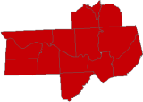
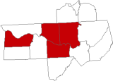
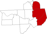
| Primary Areas Affected (Click on map for more information) |
Date of Event | Type of Event |
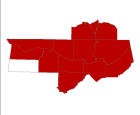 |
December 24-25, 2009 |
Non-Thunderstorm Damaging Wind |
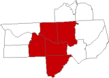 |
May 6, 2009 |
Tornadoes, Large Hail, and Damaging Wind (*) |
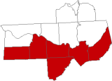 |
April 19, 2009 |
Weak Tornado Outbreak, Large Hail, and Damaging Wind |
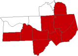 |
April 13, 2009 |
"Wake Low" Damaging Wind Event |
 |
April 10, 2009 |
Isolated Tornadoes and Large Hail |
 |
April 2, 2009 |
Tornadoes |
 |
March 28, 2009 |
Tornadoes |


 Local Radar
 Weather Map