Wichita, Kansas
Weather Forecast Office
Heat Burst Impacts Central Kansas
June 3-4th, 2014
|
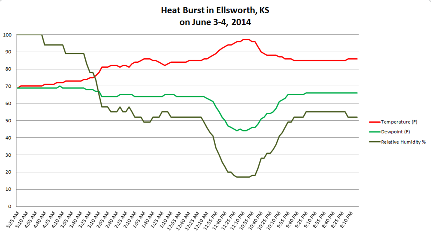
A heat burst impacted many areas of central Kansas late Tuesday night and early Wednesday morning. Locations from Hays, Kansas to Salina, Kansas recorded the heat burst on their automated weather equipment. Other locations that recorded the heat burst included Russell, Kansas and Ellsworth, Kansas. Temperatures across the area rose 5 to 15 degrees as a result of the heat burst and winds gusted to 40-50 mph. At Ellsworth, 5-minute observations were available that show the heat burst (graph below).
A heat burst is signified by a rise in the temperature, a drop in the dew point (and associated relative humidity) and strong gusty winds. |
Details from various central Kansas locations
| Peak Temperature | Peak Wind | |
| Hays | 99 | 61 mph |
| Russell | 94 | 58 mph |
| Ellsworth | 97 | 57 mph |
| Salina | 96 | 43 mph |
|
What causes a heat burst? There are two main atmospheric ingredients that are necessary for a heat burst to occur. The first is a dissipating thunderstorm or shower. Second, the mid-level atmospheric environment must be hot and dry, combined with a shallow surface inversion. Thunderstorms develop when moist, unstable air is given a nudge upward. Moisture in the cloud condenses and later falls as precipitation. Once the thunderstorm loses its updraft, the thunderstorm is said to be downdraft dominated. When this occurs with a hot and dry atmospheric mid-level in place, the moisture associated with the downdraft evaporates and initially cools this layer, increasing its rate of descent toward the surface. However, the descending air will stop cooling once all the moisture has evaporated, therefore causing adiabatic (compressional) warming and mixing of the warm(inversion) layer. The heat burst will occur once the warm and dry air descends to the surface.
|
Hazards
Briefing pages
Local weather story
Submit a storm report
Storm Prediction Center
Enhanced Hazardous Weather Outlook
Hazardous Weather Outlook Text
Current Conditions
Local Radar
National Radar
Satellite
Hourly weather(text)
Precip Analysis
Snowfall analysis
This day in weather history
7 Day Lightning Archive
Forecasts
Forecast Discussion
Weather Story
Fire Weather
Activity Planner
Aviation Weather
Soaring Forecast
Hurricane Center
Graphical Forecasts
Regional Weather Summary
Probabilistic Snow
Probabilistic QPF
Wet Bulb Globe temp
Climate
Local Climate Page
Daily/Monthly data(F6)
Daily Records
Climate Normals
Local drought page
Latest Climate Report(ICT)
Latest Climate Report(SLN)
Latest Climate Report(CNU)
CoCoRaHS
7 Day Lightning Archive
US Dept of Commerce
National Oceanic and Atmospheric Administration
National Weather Service
Wichita, Kansas
2142 S. Tyler Road
Wichita, KS 67209-3016
316-942-3102
Comments? Questions? Please Contact Us.

