Wichita, Kansas
Weather Forecast Office
A sneaky strong storm system brought rain and sleet to the area Saturday morning followed by accumulating snowfall for the afternoon and evening hours. The rain changed over to snow after 2pm across portions of central Kansas as the upper level system acquired colder air. The snowflakes were over sized and hefty at times which caused the snow to pile up in a short period of time.
The storm system maintained an easterly track across Kansas during the evening hours dragging the colder air and snowfall along with it. Several locations witnessed snowfall amounts of 2 to 3 inches from central Kansas into east central Kansas, however two separate areas of 4 to 5 inches of snow covered some locations.
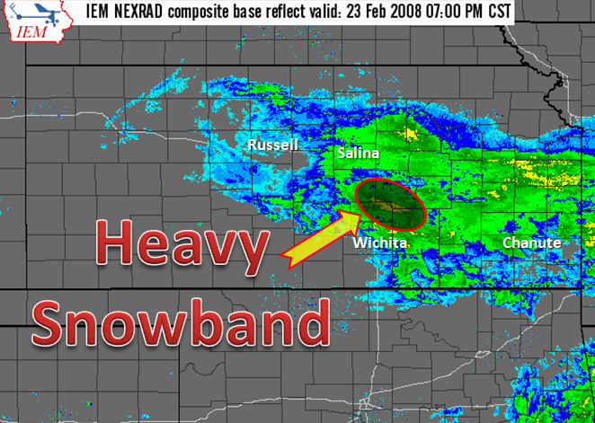
An intense snow band with high snowfall rates developed just north of Newton around 7pm. An observer trying to drive north of Newton on Interstate 135 at that time reported that local road crews were having difficulties keeping the interstate cleared off.
 Snow Amounts from February 23rd, 2008 |
 Radar image from KICT 88D radar at 7pm |
Hazards
Briefing pages
Local weather story
Submit a storm report
Storm Prediction Center
Enhanced Hazardous Weather Outlook
Current Conditions
Local Radar
National Radar
Satellite
Hourly weather(text)
Precip Analysis
Snowfall analysis
This day in weather history
7 Day Lightning Archive
Forecasts
Forecast Discussion
Weather Story
Fire Weather
Activity Planner
Aviation Weather
Soaring Forecast
Hurricane Center
Graphical Forecasts
Regional Weather Summary
Probabilistic Snow
Probabilistic QPF
Wet Bulb Globe temp
Climate
Local Climate Page
Daily/Monthly data(F6)
Daily Records
Climate Normals
Local drought page
Latest Climate Report(ICT)
Latest Climate Report(SLN)
Latest Climate Report(CNU)
CoCoRaHS
7 Day Lightning Archive
US Dept of Commerce
National Oceanic and Atmospheric Administration
National Weather Service
Wichita, Kansas
2142 S. Tyler Road
Wichita, KS 67209-3016
316-942-3102
Comments? Questions? Please Contact Us.

