Overview
|
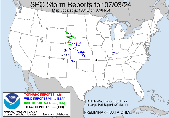
Storms tracked out of northwest Kansas and southwest Nebraska during the early evening hours of Wednesday July 3rd and moved into central Kansas around 11 pm. The line of storms accelerated southeast and produced a large swath of damaging winds as they tracked southeast through the overnight hours. There were multiple reports of 70 mph winds with the Salina Airport recording an 82 mph wind gust with a mesonet in McPherson county reporting a 76 mph gust. Unfortunately there were 3 injuries and one fatality on Wilson Lake in Russell county when a number of campers were rolled by the strong winds. |
 |
Photos & Video
|
|
|
|
|
|
Storm Reports
..TIME...   ...EVENT...      ...CITY LOCATION...     ...LAT.LON...
..DATE...   ....MAG....      ..COUNTY LOCATION..ST.. ...SOURCE....
            ..REMARKS..

1132 PM     Tstm Wnd Gst     Russell                 38.89N 98.86W
07/03/2024  M68 MPH          Russell            KS   Trained Spotter


1133 PM     Tstm Wnd Gst     Russell Airport         38.87N 98.81W
07/03/2024  M70 MPH          Russell            KS   ASOS


1134 PM     Tstm Wnd Gst     3 NNE Bunker Hill       38.91N 98.67W
07/03/2024  M60 MPH          Russell            KS   Mesonet


1145 PM     Tstm Wnd Dmg     6 N Dorrance            38.93N 98.57W
07/03/2024                   Russell            KS   Law Enforcement

            *** 1 FATAL, 3 INJ ***
            Campers blown over from high winds at Lake
            Wilson. Updated information from Russell
            county sheriff press release.

1145 PM     Tstm Wnd Dmg     8 S Lucas               38.95N 98.53W
07/03/2024                   Russell            KS   Public

            Report of multiple campers blown over at
            Wilson Lake.

1151 PM     Tstm Wnd Gst     4 ESE Wilson            38.81N 98.41W
07/03/2024  M60 MPH          Ellsworth          KS   Mesonet


1158 PM     Tstm Wnd Gst     3 SE Sylvan Grove       38.98N 98.36W
07/03/2024  E70 MPH          Lincoln            KS   Trained Spotter


1200 AM     Tstm Wnd Gst     Ellsworth               38.74N 98.22W
07/04/2024  E60 MPH          Ellsworth          KS   Trained Spotter

            Also reported an 8 inch diameter limb down.

1205 AM     Tstm Wnd Dmg     5 NE Ellsworth          38.78N 98.17W
07/04/2024                   Ellsworth          KS   Public

            Report of a house with part of the roof
            blown off about 5 miles northeast of
            Ellsworth. Also, tree limbs down in the town
            of Ellsworth. Delayed report. Report relayed
            via social media. Time estimated by radar.

1208 AM     Tstm Wnd Gst     8 NNE Kanopolis         38.82N 98.12W
07/04/2024  E70 MPH          Ellsworth          KS   Trained Spotter

            Also reported 0.85 inches of rain in 15
            minutes.

1214 AM     Tstm Wnd Gst     6 ENE Kanopolis         38.73N 98.04W
07/04/2024  M73 MPH          Ellsworth          KS   Mesonet


1233 AM     Tstm Wnd Gst     3 SW Salina             38.78N 97.65W
07/04/2024  M63 MPH          Saline             KS   ASOS

            ASOS station KSLN Salina Regional Airport.

1233 AM     Tstm Wnd Gst     8 WNW Marquette         38.61N 97.97W
07/04/2024  E70 MPH          Ellsworth          KS   Public


1235 AM     Tstm Wnd Gst     2 W Little River        38.39N 98.05W
07/04/2024  M61 MPH          Rice               KS   Mesonet


1238 AM     Tstm Wnd Gst     3 SW Salina             38.78N 97.65W
07/04/2024  M82 MPH          Saline             KS   ASOS

            ASOS station KSLN Salina Regional Airport.

1242 AM     Tstm Wnd Gst     5 SE Lyons              38.30N 98.13W
07/04/2024  M58 MPH          Rice               KS   Mesonet


1243 AM     Tstm Wnd Gst     Lindsborg               38.57N 97.68W
07/04/2024  E60 MPH          McPherson          KS   Public

            4 to 5 inch diameter limbs also reported
            down.

1251 AM     Tstm Wnd Gst     3 E Mcpherson           38.38N 97.61W
07/04/2024  E75 MPH          McPherson          KS   Trained Spotter


1252 AM     Tstm Wnd Gst     Lindsborg               38.58N 97.67W
07/04/2024  M69 MPH          McPherson          KS   Public


1255 AM     Tstm Wnd Gst     2 SW Mcpherson          38.36N 97.69W
07/04/2024  M62 MPH          McPherson          KS   AWOS


1257 AM     Tstm Wnd Gst     6 ESE Inman             38.21N 97.66W
07/04/2024  E60 MPH          McPherson          KS   Mesonet


0100 AM     Tstm Wnd Gst     1 NE Inman              38.23N 97.77W
07/04/2024  M59 MPH          McPherson          KS   Mesonet


0104 AM     Tstm Wnd Gst     1 W Canton              38.38N 97.44W
07/04/2024  M58 MPH          McPherson          KS   Mesonet


0105 AM     Tstm Wnd Gst     1 S Mcpherson           38.36N 97.66W
07/04/2024  M76 MPH          McPherson          KS   Mesonet


0109 AM     Tstm Wnd Gst     5 ESE Partridge         37.93N 98.02W
07/04/2024  M67 MPH          Reno               KS   Mesonet


0109 AM     Tstm Wnd Gst     6 N Moundridge          38.29N 97.51W
07/04/2024  M58 MPH          McPherson          KS   Public


0109 AM     Tstm Wnd Gst     1 W Canton              38.38N 97.44W
07/04/2024  M72 MPH          McPherson          KS   Mesonet


0113 AM     Tstm Wnd Gst     4 S Durham              38.43N 97.23W
07/04/2024  M63 MPH          Marion             KS   Mesonet


0115 AM     Tstm Wnd Gst     3 E Hutchinson          38.07N 97.86W
07/04/2024  M58 MPH          Reno               KS   ASOS


0125 AM     Tstm Wnd Gst     1 SW Hillsboro          38.34N 97.21W
07/04/2024  M59 MPH          Marion             KS   Mesonet


0142 AM     Tstm Wnd Dmg     2 WNW Newton            38.05N 97.37W
07/04/2024                   Harvey             KS   Public

            Large tree uprooted.

0159 AM     Tstm Wnd Gst     Sedgwick                37.92N 97.42W
07/04/2024  E60 MPH          Harvey             KS   Trained Spotter


0200 AM     Tstm Wnd Gst     2 NE Maize              37.79N 97.43W
07/04/2024  M59 MPH          Sedgwick           KS   Mesonet
 |
Media use of NWS Web News Stories is encouraged! Please acknowledge the NWS as the source of any news information accessed from this site. |
|


