Overview
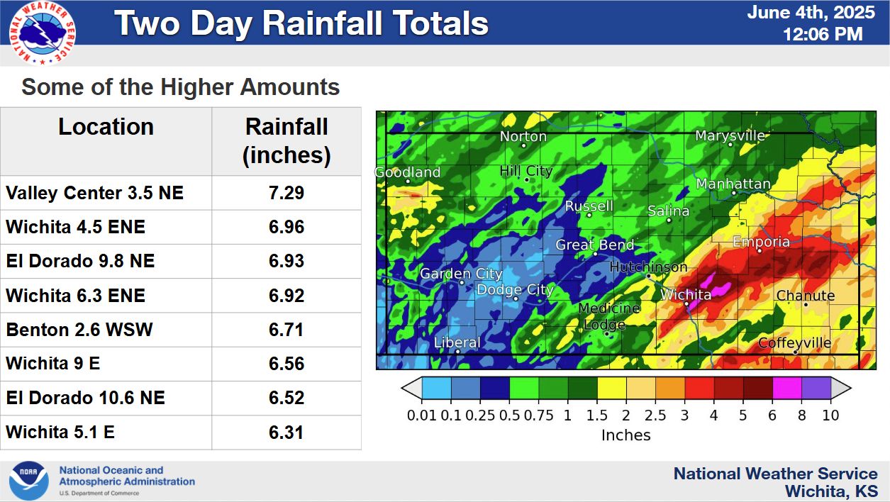
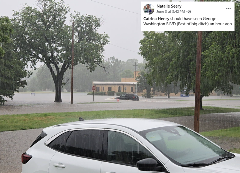
Storms developed along slow moving front during the late morning hours of Tuesday June 3rd. With a very moist airmass in place, the storms produced very high rainfall rates that caused extensive flash flooding across much of south central Kansas. Hardest hit was east Wichita to parts of northern Butler County which included El Dorado. Many of these locations received 4 to 7 inches of rainfall. Law enforcement in Wichita responded to more than 70 calls for vehicles being submerged. In addition, parts of El Dorado were evacuated as the Walnut River rapidly climbed.
Photos & Video
 |
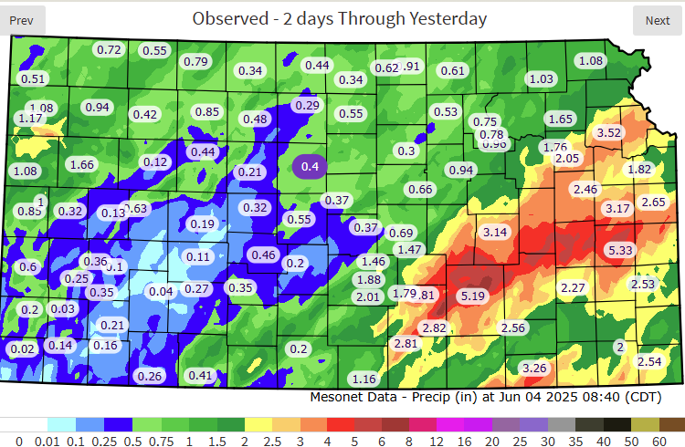 |
| Storm total rainfall amounts | Storm total rainfall amounts from the Kansas Mesonet |
 |
 |
 |
|
|
|
|
|
|
|
|
|
Radar
 |
| Radar animation from Tuesday morning into Tuesday evening |
Storm Reports
..TIME... ...EVENT... ...CITY LOCATION... ...LAT.LON...
..DATE... ....MAG.... ..COUNTY LOCATION..ST.. ...SOURCE....
..REMARKS..
1037 AM Flood Florence 38.24N 96.93W
06/03/2025 Marion KS Emergency Mngr
Emergency manager reports flooding across
parts of town.
1041 AM Flood Valley Center 37.84N 97.37W
06/03/2025 Sedgwick KS Trained Spotter
Flooding reported at the intersection of
Colby and Main Street.
1050 AM Flood 3 S Burns 38.04N 96.90W
06/03/2025 Butler KS Emergency Mngr
Water over several roadways in this area.
1122 AM Flash Flood Valley Center 37.83N 97.37W
06/03/2025 Sedgwick KS Emergency Mngr
Vehicles stuck in high water near the
intersection of Main and Emporia.
1134 AM Flood Whitewater 37.96N 97.15W
06/03/2025 Butler KS Emergency Mngr
Street flooding reported throughout the town
of Whitewater.
1145 AM Flood 1 SE East Wichita 37.67N 97.25W
06/03/2025 Sedgwick KS Emergency Mngr
Report of stalled vehicle due to high water.
1221 PM Hail 1 SSE El Dorado 37.81N 96.85W
06/03/2025 E1.00 Inch Butler KS Emergency Mngr
1221 PM Hail East Wichita 37.69N 97.26W
06/03/2025 E0.88 Inch Sedgwick KS NWS Employee
1225 PM Flood 1 W Towanda 37.79N 97.02W
06/03/2025 Butler KS Emergency Mngr
Water over a county road.
1236 PM Flood El Dorado 37.83N 96.86W
06/03/2025 Butler KS Public
Street flooding across north end of El
Dorado.
1238 PM Hail 3 N Oaklawn 37.64N 97.31W
06/03/2025 E1.00 Inch Sedgwick KS Trained Spotter
1245 PM Flash Flood 1 NW Park City 37.81N 97.34W
06/03/2025 Sedgwick KS Emergency Mngr
Broadway closed from 69th to 125th St N due
to street flooding.
1255 PM Flash Flood 4 ENE Goddard 37.68N 97.52W
06/03/2025 Sedgwick KS Broadcast Media
Maple between 151st and 167th Streets in
Goddard closed due to flooding. Via social
media.
1256 PM Flash Flood 2 NNE El Dorado 37.85N 96.85W
06/03/2025 Butler KS Emergency Mngr
Report of closure of K-77 at McCollum Rd due
to water over the road.
1257 PM Flash Flood 2 W East Wichita 37.68N 97.30W
06/03/2025 Sedgwick KS Emergency Mngr
EM reported Kellogg and Hillside ramp
flooded with vehicles unable to drive
through. Traffic backing up on Kellogg.
1257 PM Rain 2 WNW Burns 38.10N 96.91W
06/03/2025 M7.00 Inch Marion KS Emergency Mngr
0101 PM Flash Flood Benton 37.79N 97.11W
06/03/2025 Butler KS Emergency Mngr
Fire department reporting street flooding
along with pea to nickel sized hail.
0101 PM Flash Flood El Dorado 37.82N 96.86W
06/03/2025 Butler KS Emergency Mngr
Multiple vehicles reported stranded in flood
waters throughout city along with
substantial street flooding. Emergency crews
responding to stranded vehicles.
0107 PM Flash Flood 1 WNW East Wichita 37.69N 97.28W
06/03/2025 Sedgwick KS Emergency Mngr
Vehicles stalled at following intersections
in Wichita metro: Gatewood St E and
Crestwood, English and Bleckley, Murdock and
Harding, and 200 Block Bleckley.
0109 PM Flash Flood 1 WSW El Dorado 37.82N 96.88W
06/03/2025 Butler KS Emergency Mngr
City of El Dorado reporting Hwy 254 closed
and impassable for 3 blocks east of
Haverhill.
0111 PM Flash Flood 1 NE East Wichita 37.69N 97.24W
06/03/2025 Sedgwick KS Emergency Mngr
Vehicle submerged.
0111 PM Flash Flood East Wichita 37.68N 97.26W
06/03/2025 Sedgwick KS Emergency Mngr
Vehicle submerged.
0112 PM Flash Flood 3 SW East Wichita 37.66N 97.29W
06/03/2025 Sedgwick KS Emergency Mngr
Level 2 submersion - occupied vehicles
floating down the road.
0117 PM Flash Flood 1 WNW East Wichita 37.69N 97.28W
06/03/2025 Sedgwick KS Law Enforcement
Individual trapped in flooded vehicle.
0123 PM Flash Flood 3 SW East Wichita 37.66N 97.30W
06/03/2025 Sedgwick KS Emergency Mngr
Level 1 vehicle submersion with occupant
inside.
0124 PM Flash Flood 1 WNW East Wichita 37.69N 97.28W
06/03/2025 Sedgwick KS Law Enforcement
Law enforcement reported unoccupied cars
floating down Bleckley.
0125 PM Flash Flood Potwin 37.94N 97.02W
06/03/2025 Butler KS Emergency Mngr
Fire department reporting street flooding in
Potwin.
0126 PM Flash Flood 2 NNW Mcconnell Air For 37.65N 97.28W
06/03/2025 Sedgwick KS Emergency Mngr
Vehicle submersion reported due to street
flooding.
0128 PM Flash Flood 1 NW East Wichita 37.70N 97.28W
06/03/2025 Sedgwick KS Emergency Mngr
Vehicle floating down alley.
0138 PM Flash Flood 1 WSW Benton 37.79N 97.12W
06/03/2025 Butler KS Emergency Mngr
Fire department reporting Prairie Creek Rd
no largely impassable due to flooding.
0141 PM Flash Flood 2 NE East Wichita 37.71N 97.24W
06/03/2025 Sedgwick KS Law Enforcement
13th St between Rock and Webb now impassable
with flooded cars, no occupants.
0142 PM Flash Flood 1 NW East Wichita 37.70N 97.28W
06/03/2025 Sedgwick KS Emergency Mngr
2 occupied vehicles floating at intersection
of Murdock and Harding.
0143 PM Flash Flood 3 SSE Whitewater 37.92N 97.13W
06/03/2025 Butler KS Emergency Mngr
Butler Rd approximately 3 S of Whitewater
now impassable.
0144 PM Flash Flood 4 ESE Bel Aire 37.74N 97.21W
06/03/2025 Sedgwick KS Public
Flooding reported over road.
0150 PM Flash Flood 1 WSW East Wichita 37.68N 97.27W
06/03/2025 Sedgwick KS Emergency Mngr
2 vehicles submerged at Kellogg and
Edgemoor.
0154 PM Flash Flood 1 WSW East Wichita 37.68N 97.28W
06/03/2025 Sedgwick KS Dept of Highways
Webcam showing water over rightmost lane of
Kellogg at intersection of Kellogg and
Oliver.
0158 PM Flash Flood El Dorado 37.82N 96.86W
06/03/2025 Butler KS Emergency Mngr
Emergency crews evacuating at-risk homes on
north side of El Dorado.
0201 PM Flash Flood 2 N Park City 37.83N 97.32W
06/03/2025 Sedgwick KS Emergency Mngr
Small sedan washed off roadway and in ditch.
Vehicle stuck near low water bridge with
unknown number of occupants.
0204 PM Flash Flood 1 ENE Madison 38.14N 96.13W
06/03/2025 Greenwood KS Emergency Mngr
EM reporting K-58 east of Madison closed due
to flooding.
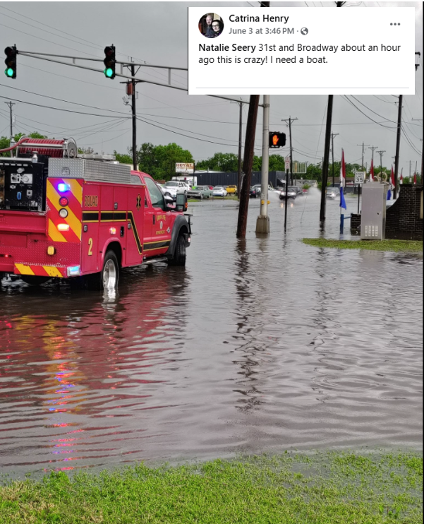
0224 PM Flash Flood 1 SSE Downtown Wichita 37.68N 97.34W
06/03/2025 Sedgwick KS Emergency Mngr
Car stalled out in high water at 800 block
of S Broadway.
0225 PM Flash Flood East Wichita 37.68N 97.26W
06/03/2025 Sedgwick KS Emergency Mngr
Car stalled in high water at intersection of
Kellogg and Woodlawn.
0226 PM Flash Flood 2 NE Downtown Wichita 37.71N 97.31W
06/03/2025 Sedgwick KS Emergency Mngr
Stalled car at intersection of 13th and Ash.
0229 PM Flash Flood 3 SW East Wichita 37.66N 97.30W
06/03/2025 Sedgwick KS Emergency Mngr
Car stalled in high water at intersection of
Hillside and Mt Vernon.
0230 PM Flash Flood 2 NNW Mcconnell Air For 37.65N 97.29W
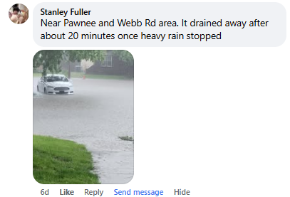
06/03/2025 Sedgwick KS Emergency Mngr
Car stalled in high water at intersection of
Pawnee and George Washington Drive.
0232 PM Flash Flood 3 NW Oaklawn 37.64N 97.34W
06/03/2025 Sedgwick KS Emergency Mngr
Estimated 10 vehicles stalled out in high
water at intersection of 31st St S and Old
Lawrence Rd.
0234 PM Flash Flood 2 ENE East Wichita 37.69N 97.23W
06/03/2025 Sedgwick KS Emergency Mngr
Multiple vehicles stalled out in high water
at intersection of Central and Webb.
0240 PM Flash Flood 1 N El Dorado 37.83N 96.86W
06/03/2025 Butler KS Emergency Mngr
Several people trapped in homes due to
flooding, with responders requiring
boats/PFDs to access. Evacuation area in
northern El Dorado expanded between N Topeka
and N Taylor.
0244 PM Flash Flood 1 ESE East Wichita 37.68N 97.24W
06/03/2025 Sedgwick KS Law Enforcement
Motel 6 reporting basement full of water.
0310 PM Flash Flood 1 SW El Dorado 37.81N 96.87W
06/03/2025 Butler KS Emergency Mngr
EM reported expansion of evacuations across
El Dorado, with active evacuation ongoing in
the southwest corner of the city.
0322 PM Flash Flood 0.5 N Madison 38.14N 96.14W
06/03/2025 Greenwood KS Emergency Mngr
Vehicle stalled in water with all occupants
rescued.
0354 PM Flash Flood Florence 38.24N 96.93W
06/03/2025 Marion KS Emergency Mngr
Doyle Creek over its banks, with flooding on
Main St in Florence 1 to 1.5 ft deep.
0404 PM Rain 3 SSW Downtown Wichita 37.65N 97.35W
06/03/2025 M4.80 Inch Sedgwick KS Broadcast Media
Storm total rainfall.
0405 PM Flash Flood 1 SSE Florence 38.24N 96.93W
06/03/2025 Marion KS Emergency Mngr
EM reported Doyle Creek flowing over road.
0413 PM Rain 1 WSW Whitewater 37.96N 97.17W
06/03/2025 M4.54 Inch Harvey KS NWS Employee
Storm total rainfall.
0447 PM Rain 1 N East Wichita 37.70N 97.26W
06/03/2025 M6.83 Inch Sedgwick KS Broadcast Media
Storm total rainfall. 5.29 in recorded since
7 am.
0504 PM Flood Iola 37.93N 95.40W
06/03/2025 Allen KS Law Enforcement
Picture sent of truck driving through water
on State Street.
0524 PM Flash Flood 3 W Yates Center 37.87N 95.79W
06/03/2025 Woodson KS Law Enforcement
Westbound lane of Highway 54 is flooded at
Jay Road.
0533 PM Flood 1 W Sedan 37.13N 96.20W
06/03/2025 Chautauqua KS Trained Spotter
Water over Highway 99 just west of Sedan.
Water also reported over the Highway just
south of town.
0800 PM Rain 2 SW El Dorado 37.80N 96.88W
06/03/2025 M5.06 Inch Butler KS Mesonet
24-hour rainfall total from 8pm 6/2 to 8pm
6/3.
0800 PM Rain 2 W Towanda 37.80N 97.03W
06/03/2025 M5.98 Inch Butler KS Mesonet
24-hour rainfall total from 6/2 8pm to 6/3
8pm.
0800 PM Rain 3 ESE Bel Aire 37.75N 97.22W
06/03/2025 M5.18 Inch Sedgwick KS AWOS
24-hour rainfall total from 6/2 8pm to 6/3
8pm.
0800 PM Rain 3 E East Wichita 37.69N 97.21W
06/03/2025 M6.21 Inch Sedgwick KS AWOS
Corrects previous rain report from 3 E East
Wichita. 24-hour rainfall total from 6/2 8pm
to 6/3 8pm.
0800 PM Rain 1 NNW Mcconnell Air For 37.63N 97.27W
06/03/2025 M5.09 Inch Sedgwick KS Mesonet
24-hour rainfall total from 6/2 8pm to 6/3
8pm.
0500 AM Rain 4 NNW Wichita Eisenhowe 37.71N 97.47W
06/04/2025 M4.45 Inch Sedgwick KS Cocorahs
2-day total.
0545 AM Rain 3 S Downtown Wichita 37.64N 97.33W
06/04/2025 M5.33 Inch Sedgwick KS Mesonet
2-day total.
0614 AM Rain 2 N Andover 37.71N 97.14W
06/04/2025 M5.00 Inch Butler KS Cocorahs
2-day total.
0630 AM Rain 1 W Towanda 37.80N 97.01W
06/04/2025 M4.69 Inch Butler KS CO-OP Observer
2-day total.
0635 AM Rain 2 W Towanda 37.80N 97.03W
06/04/2025 M5.87 Inch Butler KS Mesonet
Mesonet station FW6239 Towanda.
0635 AM Rain 3 NNE East Wichita 37.72N 97.24W
06/04/2025 M6.92 Inch Sedgwick KS Cocorahs
2-day total.
0644 AM Rain 3 WSW Benton 37.77N 97.15W
06/04/2025 M6.71 Inch Butler KS Cocorahs
2-day total.
0645 AM Rain 2 NNE El Dorado 37.85N 96.85W
06/04/2025 M5.50 Inch Butler KS Mesonet
Mesonet station KEDJE 1 NNE El Dorado. 2-day
total.
0645 AM Rain 2 N Andover 37.71N 97.14W
06/04/2025 M5.00 Inch Butler KS Cocorahs
2-day total.
0647 AM Rain 2 NNE El Dorado 37.84N 96.84W
06/04/2025 M6.10 Inch Butler KS Cocorahs
2-day total.
0655 AM Rain 1 NE Elbing 38.06N 97.12W
06/04/2025 M5.02 Inch Butler KS Cocorahs
2-day total.
0700 AM Rain 4 SSE Newton 37.99N 97.31W
06/04/2025 M3.41 Inch Harvey KS Public
24 hour total.
0700 AM Rain 2 SSE Mcconnell Air For 37.59N 97.25W
06/04/2025 M3.93 Inch Sedgwick KS Cocorahs
2-day total.
0700 AM Rain 5 NNE Peabody 38.23N 97.06W
06/04/2025 M3.95 Inch Marion KS Cocorahs
2-day total.
0700 AM Rain Sedan 37.13N 96.18W
06/04/2025 M4.19 Inch Chautauqua KS CO-OP Observer
2-day total.
0700 AM Rain Clearwater 37.50N 97.50W
06/04/2025 M4.52 Inch Sedgwick KS Cocorahs
2-day total.
0700 AM Rain 5 SSE Newton 37.98N 97.31W
06/04/2025 M4.64 Inch Harvey KS Cocorahs
2-day total.
0700 AM Rain 1 ESE El Dorado 37.82N 96.83W
06/04/2025 M5.30 Inch Butler KS CO-OP Observer
CO-OP Observer station ELDK1. 2-day total.
0702 AM Rain 3 NE Valley Center 37.87N 97.32W
06/04/2025 M7.29 Inch Sedgwick KS Cocorahs
2-day total.
0709 AM Rain 1 S El Dorado 37.80N 96.86W
06/04/2025 M5.57 Inch Butler KS Cocorahs
2-day total.
0711 AM Rain 5 NNE Towanda 37.86N 96.97W
06/04/2025 M5.76 Inch Butler KS Cocorahs
2-day total.
0730 AM Rain 4 E Kechi 37.80N 97.21W
06/04/2025 M4.98 Inch Sedgwick KS Cocorahs
2-day total.
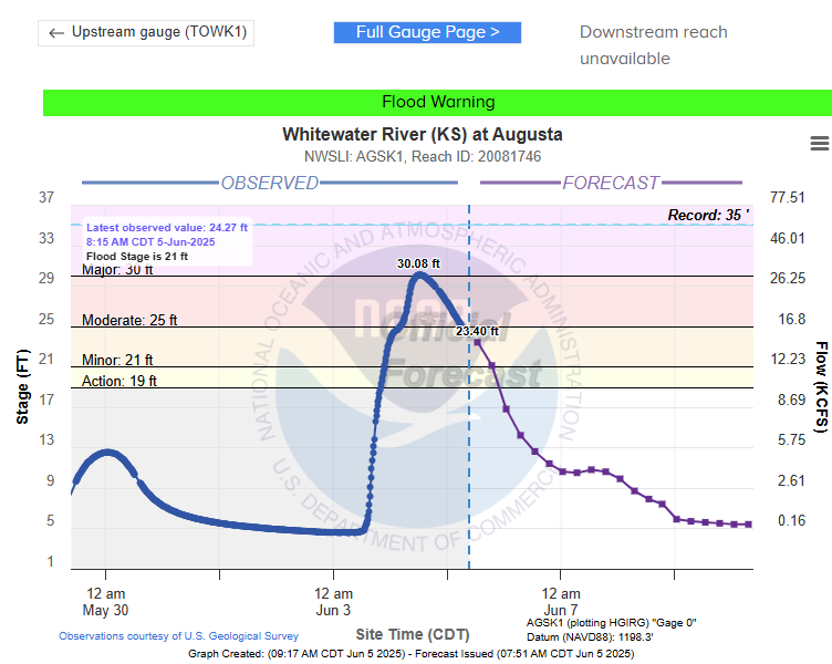
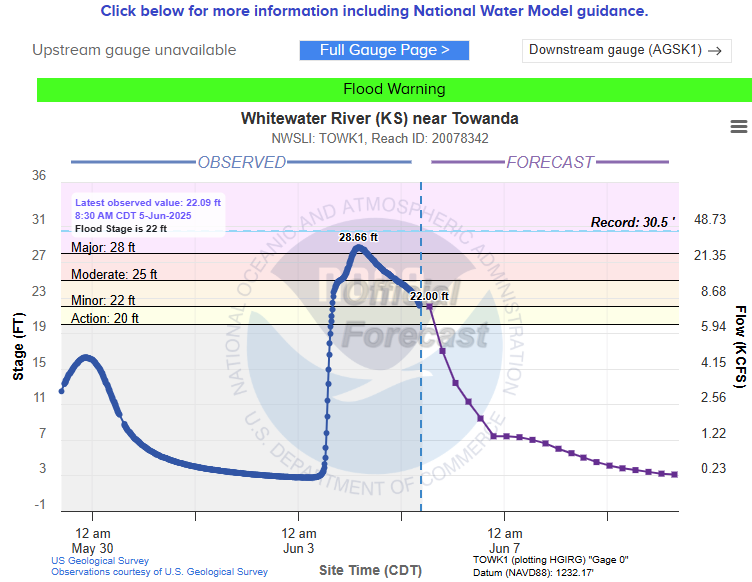
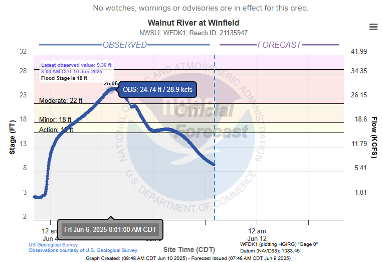
Hydrographs
|
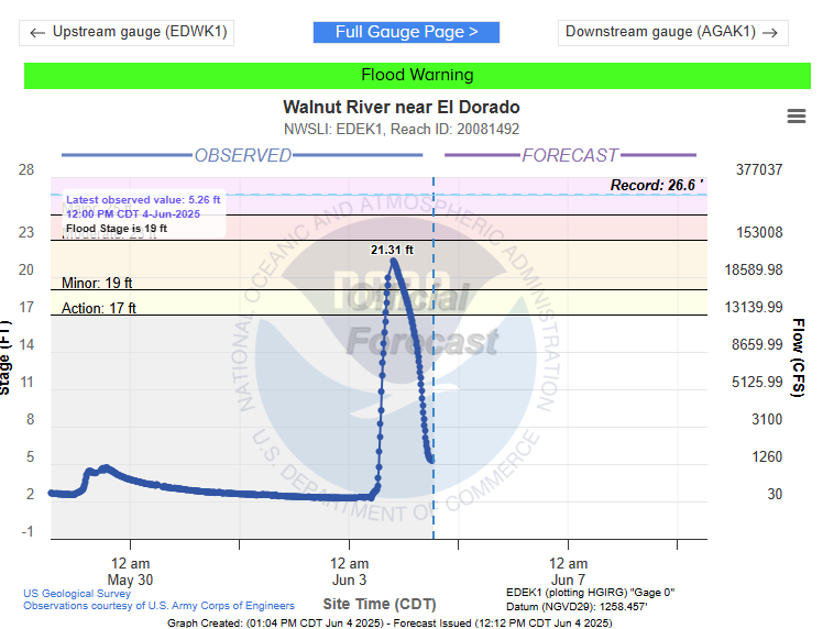
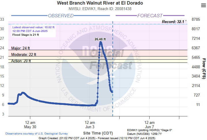
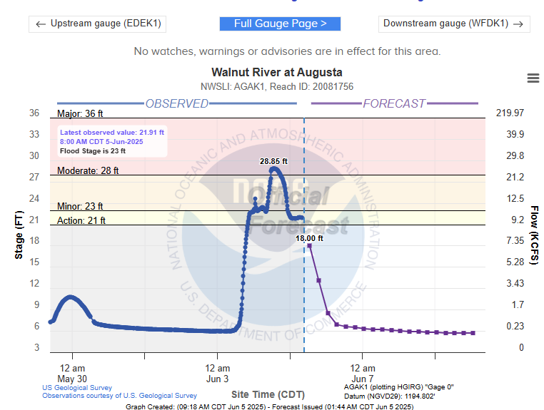
Historical river crests: Butler county streams/rivers reached levels not seen in quite some time:
|
 |
 |
 |
 |
 |
 |
 |
Media use of NWS Web News Stories is encouraged! Please acknowledge the NWS as the source of any news information accessed from this site. |
|

