Overview
|
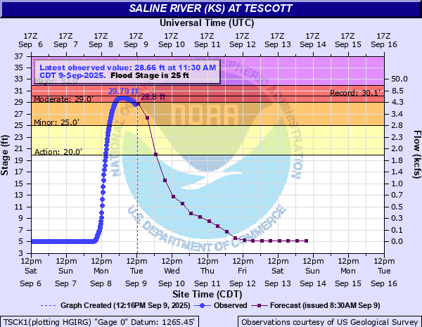
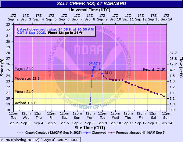
During the morning hours of Monday September 8th, a cluster of very slow moving storms produced extremely high rainfall totals across parts of Central Kansas. Many locations picked-up between 4 and 7 inches of rainfall generally west of Salina. This caused flash flooding across parts of eastern Lincoln and far western Ottawa County. Especially hard hit was the towns of Tescott and Culver. Major flooding occurred on the Salt Creek at Barnard, with it reaching a record level of 25.57 feet. Significant flooding also took plan on the Saline River, especially at Tescott, which reached moderate flood levels. |
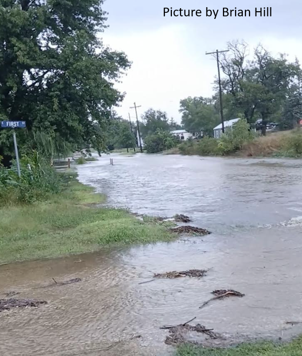 Flooding in Beverly KS. |
Photos & Video
|
Radar animation from September 8th |
Some of the higher rainfall amounts |
 |
 |
 |
| Rainfall amounts from the Kansas Mesonet |
 |
 |
 |
| River levels at Saline River at Tescott | River levels at Salt Creek near Barnard |
|
|
|
|
|
|
Storm Reports
..TIME...   ...EVENT...      ...CITY LOCATION...     ...LAT.LON...
..DATE...   ....MAG....      ..COUNTY LOCATION..ST.. ...SOURCE....
            ..REMARKS..

0720 AM     Hail             Ellsworth               38.73N 98.23W
09/08/2025  E1.00 Inch       Ellsworth          KS   Public


1055 AM     Flash Flood      7 NW Brookville         38.83N 97.97W
09/08/2025                   Ellsworth          KS   Trained Spotter

            Water is over 29th Road, 3 miles north of
            Highway 40.

1116 AM     Flash Flood      1 ENE Beverly           39.02N 97.96W
09/08/2025                   Lincoln            KS   911 Call Center

            Highway 18 just east of Beverly is closed
            due to water over the road.

1150 AM     Rain             Barnard                 39.19N 98.04W
09/08/2025  M5.00 Inch       Lincoln            KS   Trained Spotter

            Measured 5 inches of rainfall and was still
            raining.

1255 PM     Flash Flood      1 S Ellsworth           38.73N 98.23W
09/08/2025                   Ellsworth          KS   911 Call Center

            Northeast Main Street is closed in Ellsworth
            due to water over the road.

0241 PM     Rain             7 SSW Brookville        38.67N 97.89W
09/08/2025  M5.32 Inch       Saline             KS   Trained Spotter


0314 PM     Hail             1 WNW Hutchinson        38.07N 97.93W
09/08/2025  E0.50 Inch       Reno               KS   Trained Spotter


0322 PM     Rain             6 WSW Glendale          38.86N 97.96W
09/08/2025  M6.52 Inch       Ellsworth          KS   Trained Spotter

            Storm-total rainfall since midnight.

0412 PM     Rain             7 S Windom              38.28N 97.91W
09/08/2025  M2.97 Inch       McPherson          KS   CO-OP Observer

            Storm total since midnight.

0429 PM     Flash Flood      Brookville              38.77N 97.86W
09/08/2025                   Saline             KS   Emergency Mngr

            Widespread flooding in around the Brookville
            area, including roads and the city park.

0437 PM     Flood            1 NW Hutchinson         38.08N 97.92W
09/08/2025                   Reno               KS   Law Enforcement

            Flooding of various streets in the
            fairgrounds and nearby as well.

0600 AM     Rain             7 WNW Marquette         38.60N 97.95W
09/09/2025  M4.22 Inch       Ellsworth          KS   Cocorahs


0631 AM     Rain             Geneseo                 38.51N 98.16W
09/09/2025  M3.60 Inch       Rice               KS   Cocorahs


0700 AM     Rain             2 SE Salina             38.79N 97.59W
09/09/2025  M3.08 Inch       Saline             KS   Cocorahs


0700 AM     Rain             4 SSW Smolan            38.69N 97.70W
09/09/2025  M3.23 Inch       Saline             KS   Cocorahs


0700 AM     Rain             6 NNE Marquette         38.64N 97.80W
09/09/2025  M5.11 Inch       Saline             KS   Cocorahs


0700 AM     Rain             1 ESE Glendale          38.89N 97.85W
09/09/2025  M4.74 Inch       Saline             KS   Cocorahs


0700 AM     Rain             6 WNW Salina            38.84N 97.72W
09/09/2025  M3.05 Inch       Saline             KS   Cocorahs


0700 AM     Rain             8 ENE Glendale          38.95N 97.74W
09/09/2025  M4.85 Inch       Saline             KS   Cocorahs


0700 AM     Rain             Sterling                38.21N 98.21W
09/09/2025  M3.06 Inch       Rice               KS   CO-OP Observer


0700 AM     Rain             6 NE Nickerson          38.20N 98.01W
09/09/2025  M3.53 Inch       Rice               KS   Cocorahs


0700 AM     Rain             6 SSW Lindsborg         38.50N 97.70W
09/09/2025  M3.10 Inch       McPherson          KS   Cocorahs


0700 AM     Rain             2 ENE Westfall          38.95N 97.96W
09/09/2025  M3.76 Inch       Lincoln            KS   Cocorahs


0700 AM     Rain             Kanopolis               38.70N 98.15W
09/09/2025  M3.00 Inch       Ellsworth          KS   Cocorahs


0700 AM     Rain             4 NE Kanopolis          38.75N 98.10W
09/09/2025  M4.00 Inch       Ellsworth          KS   Cocorahs


0700 AM     Rain             6 SSE Westfall          38.85N 97.96W
09/09/2025  M4.63 Inch       Ellsworth          KS   Cocorahs


0715 AM     Rain             9 NW Marquette          38.64N 97.97W
09/09/2025  M4.50 Inch       Ellsworth          KS   Cocorahs


0730 AM     Rain             1 NNW Lindsborg         38.58N 97.68W
09/09/2025  M3.14 Inch       McPherson          KS   Cocorahs
 |
Media use of NWS Web News Stories is encouraged! Please acknowledge the NWS as the source of any news information accessed from this site. |
|


