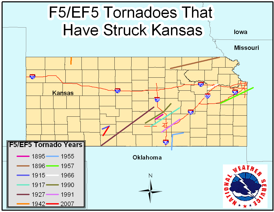
| Historical Kansas F5/EF5 Tornadoes |
|
As all know, Kansas is situated in the heart of “Tornado Alley”. In fact, according to statistics compiled and obtained from the Storms Prediction Center (SPC) in Norman, Oklahoma, from January 1950-December 2009, Kansas ranks second nationally in average number of tornadoes per year (60) and third in tornadoes per 1,000 square miles (44). It’s important to note that the marked increase in tornadoes reported in recent years has been due in no small part to an extensive, well-trained storm spotter network as well as chase teams who have also provided critical real-time reports. Since 1950, per SPC statistics, Kansas ranks first in the nation in total number of F5/EF5 tornadoes (7), monstrosities that possess rotational velocities of 261-318 mph. |
 |
|
However, research conducted by Tom Grazulis in his book Significant Tornadoes 1880-1990, F5 tornadoes have been documented striking Kansas as far back as May 1, 1895. Click HERE for additional Kansas tornado climatology facts and figures since 1950. So let’s climb into our “Tornado Time Machines” and take a ‘whirlwind tour’ into the past (in some cases the distant past) and see just when, and where, these violent tornadoes have struck in Kansas. You may be surprised when you see a few of the events that gained admission into this “Elite Tornado Fraternity”.
|
|
May 1st, 1895
Counties Affected: Sedgwick, Harvey; Length: 22 Miles; Average Width: Nearly 1 Mile; Killed: 8 (Possibly 19); Injured: 25
This horrific tornado began in extreme Northwest Sedgwick County around 430 PM, passing just west of Halstead and ending 6 miles northwest of Newton. At a minimum, 25 farms were leveled and a few vanished entirely. Four deaths occurred in each of two families who reportedly hesitated to take cover in their storm cellars. It is very possible they didn’t recognize the huge funnel as being a tornado. (NOTE: This was one reason why so many were killed in the “Tri-State Tornado” as well as a few others listed below.) Debris was carried for many miles with dead livestock found everywhere. As many as 11 others may have eventually died, hence the “possibly 19” listed among the fatalities.
May 17th, 1896
Counties Affected: Washington, Marshall, Nemaha, Brown & Richardson (Nebraska); Length: ~100 Miles; Average Width: 1 Mile; Maximum Width: 2¼ Miles; Killed: 21; Injured: 200; Damage: $400,000
Initially touching down around 500 PM five miles southwest of Palmer in South-Central Washington County, the tornado moved east/northeast across Southern Marshall County. It then veered toward the northeast, passing 1 mile south of Frankfort in Southeast Marshall County where the huge vortex was seen for half an hour as it approached. In Nemaha County, the towns of Seneca, Oneida and Sabetha suffered incredible devastation as 15 people were killed; 6 in Seneca, 6 in Oneida, and 3 in Sabetha. In Seneca, the opera house was swept off its foundation while the court house and a new $40,000 schoolhouse were destroyed. Many farms vanished with the countryside left “bare as the prairie”. As the tornado roared across Northwest Brown County it widened incredibly to between 2 and 2 ½ miles as it ran roughshod through the tiny town of Reserve in extreme North-Central Brown County where 5 more were killed and only 3 buildings were undamaged. The vicious vortex then crossed the Kansas/Nebraska border just northeast of Reserve.
June 11, 1915
Counties Affected: Kiowa; Length: 15 Miles; Average Width: Almost 1 mile; Killed: NONE; Injured: NONE; Damage: $75,000
Initial touchdown occurred around 730PM just southwest of Mullinville. The tornado moved slowly, allowing people to seek shelter from this extremely large tornado. One farmstead was completely swept away on the edge of Mullinville and many other homes were leveled. As it veered toward the northeast, then north/northeast, eight suction vortices were observed beneath the parent tornado. Reportedly, 3 mules were carried 2 miles.
May 25th, 1917
Counties Affected: Sedgwick, Harvey, Northwest Butler, Marion; Length: 65 Miles; Average Width: ¾ Mile; Maximum Width: 1½ Miles; Killed: 23; Injured: 70; Damage $600,000
Initial touchdown occurred four miles northwest of Cheney around 200 PM. The huge, vicious vortex raced northeast through Andale, Sedgwick and, with less intensity, three miles northeast of Florence. Along its track, 118 farms, homes and businesses were leveled, of which many completely vanished. In Andale, 12 were killed as half the town was heavily damaged or destroyed. In Sedgwick, 8 were killed on the east side of town. Two were killed near McLain and one near Elbing in extreme Northwest Butler County. It's somewhat surprising that the number of injuries and fatalities wasn't even higher as the tornado raced through these areas at an average speed of 65 mph! At the time, it was the fastest tornado on record. With a track 65 miles long, this meant the tornado was in progress for 1 hour.
May 7th, 1927
Counties Affected: Comanche, Barber, Kingman, Reno, McPherson; Length: 95 Miles; Average Width: 1 Mile; Maximum Width: 2 Miles; Killed: 10; Injured: 300; Damage: $1.3 Million
Likely comprised of two huge funnels, the tornado initially touched down in extreme Southeast Comanche County around 600 PM. The tornado was extremely visible, thereby enabling most people to seek shelter. The vortex intensified quickly, reaching an incredible 1 to 2 miles wide along most of its 95-mile long rampage across Barber, Kingman, Eastern Reno, and Central McPherson Counties. The incredible width of the tornado no doubt figured greatly in the large injury total. The tornado finally dissipated 7 miles south-southwest of McPherson. Around 100 farms were hit; many of which completely vanished. One person was killed 2 miles west of Kingman, three were killed in East Hutchinson where $750,000 damage occurred (remember this was in 1927), and two were killed in McPherson County. The other four fatalities occurred 1 mile southeast of Medicine Lodge in Central Barber County.
April 29th, 1942
Counties Affected: Decatur; Length: 20 Miles; Average Width: 300 Yards; Killed 15; Injured; 25; Damage: $100,000
Developing 8 miles south of Oberlin around 1030 PM, this relatively narrow but extremely intense twister moved almost due north directly toward Oberlin. The twister passed just 1/2 mile east of town and continued its ravaging path 5 ½ miles north of Oberlin along U.S. Route 83. The twister weakened and dissipated just east of Cedar Bluffs. Three entire families were killed with all farm buildings swept from their foundations along with several inches of top soil. It was considered the worst disaster in the history of this small town since the Cheyenne Indian Raid of September 9th, 1878.
May 25th, 1955: The Udall Tornado – Deadliest in Kansas History
Counties Affected: Kay (Oklahoma), Sumner, Cowley; Length: 30 Miles; Average Width: ¾ Mile; Killed: 80 (75 in Udall); Injured 270; Damage: $2.225 Million
Initially touching down at 1015 PM just south of the Kansas/Oklahoma border in extreme Northeast Kay County, the terrifying F5 twister was actually the second of two F5 tornadoes that tore through North-Central Oklahoma and South-Central Kansas that night; forming just as the equally infamous Blackwell, Oklahoma F5 tornado was dissipating very close to South Haven. (NOTE: Reportedly, the Blackwell F5 tornado was lit profusely by lightning flashes that ranged from 60 to 1,500 flashes per minute, causing the funnel to glow and possess arcs of light!) The Udall Tornado roared into the southwest edge of town around 1035 PM, and moved northeast through the heart of town where it caused almost complete devastation. In all, 192 buildings were destroyed of which 170 were homes. Only 1 building was habitable. The tornado struck a parked freight train at nearly a 90-degree angle. The 75 fatalities and 270 injuries accounted for about 70% of the Udall population.
May 20, 1957
Counties Affected: Franklin, Miami, Johnson; Length: 71 Miles; Width: ½ Mile; Killed: 7; Injured: 31; Damage: $2.5 Million
Beginning 2 miles northeast of Williamsburg in Franklin County, the powerful vortex passed 2 miles south of Ottawa, then 5 miles south of Wellsville before crossing the Kansas/Missouri border 13 miles south of Kansas City. In Kansas, 7 were killed and 31 injured with many homes leveled and many reports of multiple suction vortices. Two were killed just southeast of Ottawa where a farm was leveled. Other houses were leveled just north of Rantoul. This tornado would roar through the South Kansas City suburbs of Ruskin Heights and Hickman Mills. Pilots in the area reported debris at an altitude of 30,000 feet.
June 8th, 1966: Topeka
Counties Affected: Shawnee; Length: 22 Miles; Average Width: ¾ Mile; Killed: 16; Injured: 406; Damage: $100 Million
Touching down in Southwest Shawnee County just south southeast of Dover at 700 PM, the twister quickly intensified as it moved northeast directly over Burnett’s Mound. Downtown Topeka took a direct hit with a large part of the state Capital devastated. Around 820 homes were leveled with another 3,000 badly damaged. Most of the damage occurred in an 8-mile long, 4-block wide path right through the heart of the city. Included in these hardest hit areas was Washburn University, which sustained around $10 million damage. In fact, the capitol building was nearly hit with paint peeled from the dome. As the tornado continued its northeast rampage through Northeast Topeka, it narrowly missed the Weather Bureau Forecast Office at Billard Airport. At the time, it was the costliest natural disaster in Kansas history.
March 13th, 1990
Counties Affected: Reno, Harvey, McPherson; Length: 48 Miles; Average Width: ¾ Mile; Killed: 1; Injured: 60; Damage: $25 Million (Harvey County)
What became known as the “Hesston Tornado” actually had its inception at 434 PM, about a mile or two northeast of Pretty Prairie in extreme South-Central Reno County. It quickly attained a width of around 350 yards, causing F1-F2 damage as it churned northeast between Castleton and Cheney Lake. The tornado widened dramatically to nearly ¾ mile as it approached Haven, inflicting F4 damage to many homes that were completely demolished. Nearly constant F3 damage occurred from Haven to Burrton.
Northeast of the Little Arkansas River, the tornado narrowed to about 300 yards, however the worst damage would occur shortly thereafter as the vicious vortex roared into Hesston. Many homes and businesses were completely destroyed with several swept from their foundations. Sections of the damage track in Hesston achieved F5 intensity. Considering the magnitude of the tornado, it was fortunate (again, the term is applied very loosely here) that there was only 1 fatality and 60 injuries.
March 13th, 1990
Counties Affected: Harvey, McPherson, Marion; Length: 22 Miles; Average Width: ¾ Mile; Killed: 1; Injured: NONE; Damage not reported
The beginning of this second F5 tornado was dramatic to the say least. It formed at 535 PM, one mile north of Hesston just south of the Harvey/McPherson County line as the Hesston tornado was beginning to weaken. Over the span of only a few miles, this twister quickly intensified as it traveled nearly parallel to the weakening “Hesston” tornado, ingesting its predecessor as it entered the rope stage. The result was a vicious vortex that went on a rampage as it crossed the McPherson County/Marion County line 1 mile southwest of Goessel. It was here that the lone fatality occurred; an elderly woman who had lived in an army barracks that had been converted into a home (but with no basement). The huge funnel continued its northeast track over Southwest Marion County, passing just southeast of Hillsboro. The tornado dissipated near Marion Lake.
April 26th, 1991: Wichita/Andover
Counties Affected: Sedgwick, Butler; Length: 46 Miles; Average Width: ½ Mile; Killed: 17; Injured: 225; Damage: $300 Million ($62 Million to McConnell Air Force Base)
Beginning at 457 PM about 1 ½ miles south of Clearwater, the vicious twister fluctuated between F2 and F3 intensity as it tore through Haysville. It firmly established F3 intensity as it roared through the east side of Haysville. The twister struck McConnell Air Force Base as an F3 vortex, destroying the base school, hospital, and part of the housing. The tornado narrowly missed a line-up of around 10 B1 bombers, each worth around $280 million. The base sustained around $62 million damage. As the twister vacated McConnell, it achieved F4 intensity. The twister reached F5 intensity at 635 PM as it crossed the Sedgwick/Butler County line. It roared into Andover, drawing a bead on the Golden Spur mobile home park which was devastated. It was at the mobile home park where 13 of the 17 fatalities occurred. The tornado continued onto El Dorado by which time it had weakened to F2-F3 intensity. The tornado dissipated after crossing El Dorado Lake.
May 4th, 2007: Greensburg
Counties Affected: Comanche, Kiowa; Length: 26 Miles; Maximum Width: 1¾ Miles; Killed: 11; Injured: 63; Damage: $250 million
This terrifying tornado started in Comanche County and entered Kiowa County at 903 PM. It curved north, then northwest, then made a complete loop 2 miles northwest of Greensburg as it dissipated. This tornado, which drew, and continues to draw, national attention, leveled or destroyed 95% of Greensburg. So powerful was the twister that, despite adequate warning, 11 people were killed, some of whom were in basements. In all, 961 homes and businesses were destroyed, 216 sustained major damage and 307 received minor damage. Several oil storage tanks were destroyed, no doubt causing environmental concerns. Some debris hadn’t been cleaned up as late as July 26th and Highway 54, which runs through town, was closed for a month. This monstrous vortex went down in history as the first tornado to be rated EF5 on the new Enhanced Fujita Scale with windspeeds that were estimated at 205 mph. It was also the first magnitude F5/EF5 tornado to occur since the Moore, Oklahoma F5 Tornado of May 3, 1999; an incredible twister that contained speeds of around 315 mph.

