Overview
|
A fast-moving Quasi-Linear Convective System (QLCS) in an anomalously warm and humid mid-winter environment preceding an Arctic cold front swept across central Indiana and other portions of the lower Ohio Valley on Sunday afternoon and evening, December 28, 2025. Damaging straight-line winds were reported in several locations, along with multiple tornadoes. One brief tornado occurred in central Indiana, in the town of Linton in Greene County. This tornado path was surveyed by NWS Indianapolis on Monday, December 29, 2025, and determined to be of EF-1 intensity, with estimated peak winds of 100 MPH. |
Tornadoes
Select a tornado from the table to zoom into the track and view more information. The default table view is limited to 8 tracks, but can be scrolled by a mouse wheel or dynamically expanded. Additionally, the table can fill the entire window by clicking the small circular expanding arrow icon at the very top right of the table and returned to its original size by clicking the button again. The side information panel that opens over the map can be closed using the "X" on the upper right corner of the pop-up. Zoom into the map and click damage points to see detailed information and pictures from the surveys.
|
NOTE: times shown below are local to your device's time zone. |

The Enhanced Fujita (EF) Scale classifies tornadoes into the following categories:
| EF0 Weak 65-85 mph |
EF1 Moderate 86-110 mph |
EF2 Significant 111-135 mph |
EF3 Severe 136-165 mph |
EF4 Extreme 166-200 mph |
EF5 Catastrophic 200+ mph |
 |
|||||
| Tornadoes that fail to impact any ratable damage indicators on the EF-Scale are rated EF-Unknown (EF-U) | |||||
Radar
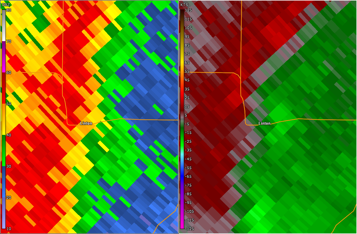 |
| Radar/Storm Relative Velocity Image at 7:19 PM EST |
Storm Reports
Preliminary Local Storm Report
National Weather Service Indianapolis IN
Sun Dec 28 2025

..TIME...   ...EVENT...      ...CITY LOCATION...     ...LAT.LON...
..DATE...   ....MAG....      ..COUNTY LOCATION..ST.. ...SOURCE....
            ..REMARKS..

0652 PM     Tstm Wnd Gst     4 W Bainbridge          39.76N 86.88W
12/28/2025  M52 MPH          Putnam             IN   Emergency Mngr

0655 PM     Tstm Wnd Gst     1 W Knightsville        39.52N 87.10W
12/28/2025  M64 MPH          Clay               IN   Public

0718 PM     Tornado          1 WSW Linton            39.03N 87.17W
12/28/2025                   Greene             IN   NWS Storm Survey

            *** 1 INJ ***
            An EF-1 tornado with peak winds of 100 mph
            and a path length of 1.12 miles began at
            this location. The path width maximum was 75
            yards.

0718 PM     Tstm Wnd Dmg     2 E Vincennes           38.68N 87.47W
12/28/2025                   Knox               IN   Emergency Mngr

            multiple tree damage reports E and NE of
            Vincennes. Time estimated from radar.

0725 PM     Tstm Wnd Dmg     2 N Brownsburg          39.87N 86.39W
12/28/2025                   Hendricks          IN   Public

            Delayed report. Large tree down. Time
            estimated via radar.

0733 PM     Tstm Wnd Gst     1 NE Mccormicks Creek S 39.30N 86.75W
12/28/2025  M61 MPH          Owen               IN   Public

0740 PM     Tstm Wnd Gst     2 SE Indianapolis Int`l 39.70N 86.26W
12/28/2025  M70 MPH          Marion             IN   Mesonet

            Mesonet station IN053 I-465 Kentucky Ave.

0750 PM     Tstm Wnd Dmg     Whitehall               39.17N 86.57W
12/28/2025                   Monroe             IN   NWS Employee

            Small tree uprooted. Time estimated from
            radar.

0820 PM     Tstm Wnd Dmg     1 W Spurgeons Corner    39.07N 86.16W
12/28/2025                   Brown              IN   Public

            Trees down in area. Time estimated from
            radar.
 |
Media use of NWS Web News Stories is encouraged! Please acknowledge the NWS as the source of any news information accessed from this site. |
|

