Overview
|
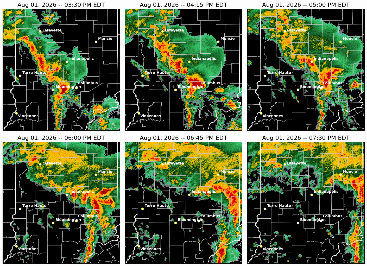
A slow-moving low-pressure system produced a tornado, heavy rain and flooding as well as a few severe storms on August 1st. The Indianapolis International Airport received more rain on August 1st than during the entire month of July. |
Tornadoes
Select a tornado from the table to zoom into the track and view more information. The default table view is limited to 8 tracks, but can be scrolled by a mouse wheel or dynamically expanded. Additionally, the table can fill the entire window by clicking the small circular expanding arrow icon at the very top right of the table and returned to its original size by clicking the button again. The side information panel that opens over the map can be closed using the "X" on the upper right corner of the pop-up. Zoom into the map and click damage points to see detailed information and pictures from the surveys.
|
NOTE: times shown below are local to your device's time zone. |

The Enhanced Fujita (EF) Scale classifies tornadoes into the following categories:
| EF0 Weak 65-85 mph |
EF1 Moderate 86-110 mph |
EF2 Significant 111-135 mph |
EF3 Severe 136-165 mph |
EF4 Extreme 166-200 mph |
EF5 Catastrophic 200+ mph |
 |
|||||
| Tornadoes that fail to impact any ratable damage indicators on the EF-Scale are rated EF-Unknown (EF-U) | |||||
Storm Reports
Below are flooding or damage reports received by NWS Indianapolis
Preliminary Local Storm Report...Summary
National Weather Service Indianapolis IN

..TIME...   ...EVENT...      ...CITY LOCATION...     ...LAT.LON...
..DATE...   ....MAG....      ..COUNTY LOCATION..ST.. ...SOURCE....
            ..REMARKS..

0354 PM     Tstm Wnd Dmg     Nashville               39.21N 86.24W
08/01/2026                   Brown              IN   Amateur Radio

            Estimated 40 plus mph wind gusts. Small
            branches and limbs down.

0511 PM     Flood            1 SW Shelbyville        39.51N 85.78W
08/01/2026                   Shelby             IN   Public

            Torrential rains...causing standing water
            with heavy currents and flow. Vehicles
            needing to change direction.

0523 PM     Tstm Wnd Dmg     3 S Monument Circle     39.73N 86.15W
08/01/2026                   Marion             IN   Storm Chaser

            Few trees down/uprooted, one fell on a
            house. Light roof damage to another house.
            Time estimated from radar.

0551 PM     Flood            1 SW Beech Grove        39.70N 86.11W
08/01/2026                   Marion             IN   Broadcast Media

            High water on parts of the interstates
            including Interstate 65 north bound near
            Interstate 465..traffic able to get through.

0555 PM     Flood            1 N Avon                39.78N 86.38W
08/01/2026                   Hendricks          IN   Public

            Parking lot at baseball field off of North
            Dan Jones Road is flooded with about 7
            inches of water.

0602 PM     Tstm Wnd Dmg     5 NNE Straughn          39.88N 85.25W
08/01/2026                   Henry              IN   Public

            Multiple trees down/uprooted, largely laying
            to the NW and N. Numerous trees down as well
            and flooding in field. One window broken on
            house.

0602 PM     Tstm Wnd Dmg     4 NNE Straughn          39.86N 85.26W
08/01/2026                   Henry              IN   Public

            Tree uprooted.

0604 PM     Tstm Wnd Dmg     7 S Mooreland           39.90N 85.23W
08/01/2026                   Henry              IN   Public

            Multiple trees snapped and at least one
            uprooted tree. Metal shed flipped. Time
            estimated from radar.

0610 PM     Tstm Wnd Dmg     3 W Arlington           39.65N 85.63W
08/01/2026                   Rush               IN   Public

            Tree uprooted.

0613 PM     Flood            2 NE Warren Park        39.80N 86.03W
08/01/2026                   Marion             IN   Public

            Flooding is exiting the street and flowing
            onto the sidewalks. Report relayed by
            AccuWeather from a citizen.

0614 PM     Flood            3 SSW Rushville         39.57N 85.46W
08/01/2026                   Rush               IN   Emergency Mngr

            Reports of high water across the road 3
            miles south of Rushville on State Rd. 3.

0630 PM     Flash Flood      3 NNW Shelbyville       39.56N 85.79W
08/01/2026                   Shelby             IN   Dept of Highways

            Flooding on I-74. Time approximate.

0630 PM     Flash Flood      2 NE Warren Park        39.80N 86.03W
08/01/2026                   Marion             IN   Dept of Highways

            Exit ramp closed due to flooding I-465 and
            I-70. Time approximate.
Rain Reports
Below are 24 hour and 48 hour rainfall totals, ending at 8:00 AM EDT August 2, based upon reports received by NWS Indianapolis. Please note that the totals on the map may not match your location exactly. A text listing of rainfall reports follows the maps. Want to contribute to rainfall reporting? Join CoCoRaHS - Community Collaborative Rain, Hail & Snow Network


Public Information Statement
National Weather Service Indianapolis IN
426 PM EDT Sun Aug 2 2026

...48 HOUR PRECIPITATION REPORTS OF 2 INCHES OR MORE...

Location                 Amount     Provider
Shelbyville 1.6 SSE      5.19 in    COCORAHS
Indianapolis 3.2 S       4.87 in    COCORAHS
New Ross 3 SSW           4.70 in    AWS
Ladoga 3.4 E             4.69 in    COCORAHS
Brownsburg 4.6 S         4.60 in    COCORAHS
Edinburgh 0.8 ENE        4.52 in    COCORAHS
Monrovia 0.6 N           4.43 in    COCORAHS
Otterbein 2.3 SE         4.33 in    COCORAHS
Wilkinson 5 W            4.21 in    AWS
Columbus 1.7 N           4.08 in    COCORAHS
Carpentersville 1 S      3.91 in    AWS
Morristown 3.8 ENE       3.85 in    COCORAHS
Hope 5.2 NW              3.68 in    COCORAHS
Princes Lakes 2.2 SSW    3.61 in    COCORAHS
Greencastle              3.56 in    AWOS
Greenfield 1.2 SE        3.54 in    COOP
New Market 1 ESE         3.49 in    AWS
Rushville 0.7 ENE        3.40 in    COCORAHS
Lebanon 4.4 W            3.34 in    COCORAHS
Pendleton                3.07 in    CWOP
Reelsville 2.6 SSW       3.04 in    COCORAHS
Anderson 2.0 S           3.02 in    COCORAHS
Morgantown 6.7 SSE       2.96 in    COCORAHS
Jamestown 0.2 NNE        2.94 in    COCORAHS
Sharpsville              2.88 in    CWOP
Bloomington 6.3 E        2.84 in    COCORAHS
West Point 4.0 NW        2.81 in    COCORAHS
McCordsville 1.7 SW      2.78 in    COCORAHS
Sheridan 0.3 ENE         2.71 in    COCORAHS
Nashville 6.6 WNW        2.63 in    COCORAHS
Gessie 0.7 SW            2.57 in    COOP
New Castle 2.4 SW        2.52 in    COCORAHS
Crawfordsville           2.49 in    AWOS
Muncie 2.2 SSE           2.48 in    COCORAHS
Cloverdale 3.5 W         2.45 in    COCORAHS
Covington 0.4 WNW        2.43 in    COCORAHS
Carmel 1.5 W             2.40 in    COCORAHS
Union City 3.6 WSW       2.38 in    COCORAHS
Kokomo 4.6 ESE           2.32 in    COCORAHS
Terre Haute 6.5 N        2.24 in    COCORAHS
Bloomington              2.22 in    CWOP
Carmel 3.3 W             2.20 in    COCORAHS
Mooresville 4.4 SE       2.17 in    COCORAHS
Fortville                2.12 in    CWOP
West Lafayette 5.9 N     2.11 in    COCORAHS
Columbus 2 S             2.09 in    COOP
Tipton                   2.08 in    CWOP
Mccordsville 2.6 NE      2.00 in    COCORAHS

Observations are collected from a variety of sources with varying
equipment and exposures. We thank all volunteer weather observers
for their dedication. Not all data listed are considered official.

$$
Radar
Zoom in of radar for Indy tornado followed by a radar loop of the event:
 |
| Figure 1: Radar at 5:21 PM EDT (Clockwise from upper left: reflectivity, velocity, storm relative velocity, and correlation coefficient) |
Environment
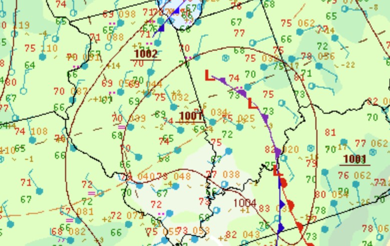
Surface low pressure and an upper level low moved slowly east across the area.
 |
 |
 |
| Figure 1: Surface Map at 5:00 PM EDT | Figure 2: 850mb at 4:00 PM EDT | Figure 3: 500mb at 4:00 PM EDT |
Instability was able to increase during the afternoon, and shear was available from the proximity of the system.
 |
 |
 |
| Figure 4: MLCAPE at 4:00 PM EDT | Figure 5: Effective Shear at 4:00 PM EDT | Figure 6: 0-1km CAPE and Surface Vorticity at 4:00 PM EDT |
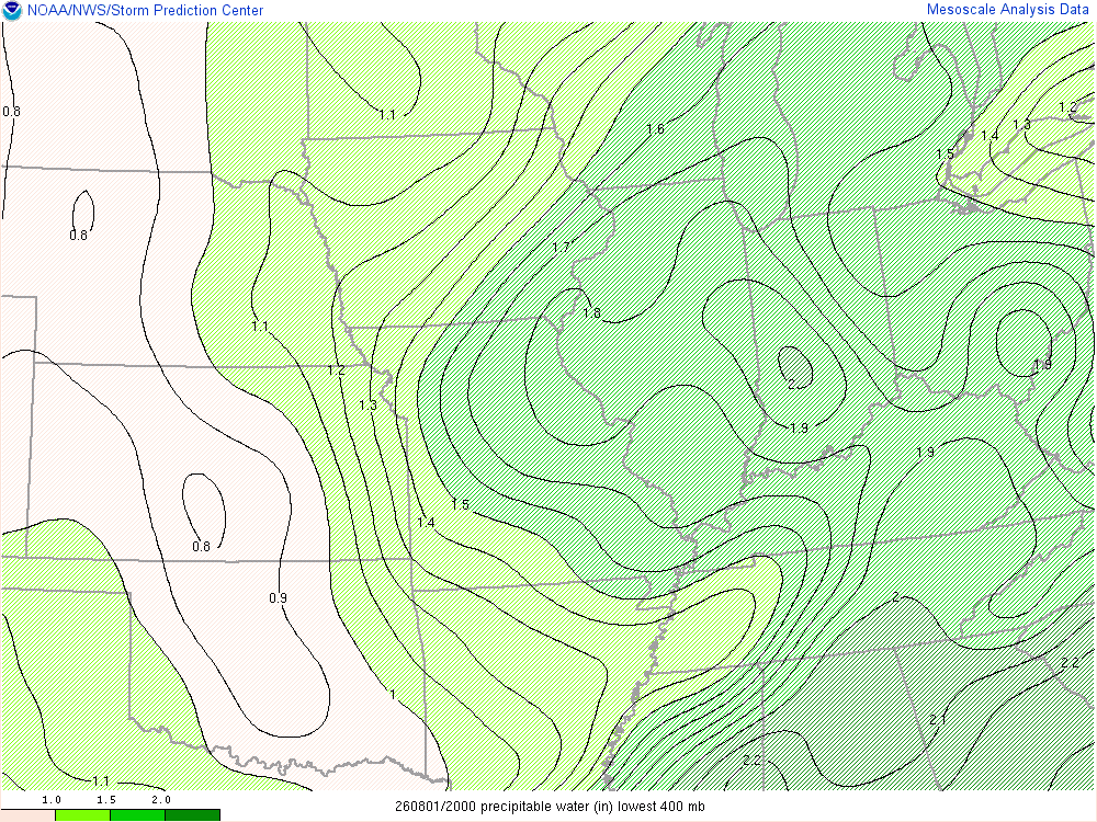
The atmosphere contained plentiful moisture for the system to work with.
 |
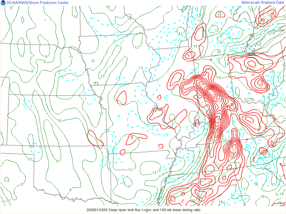 |
| Figure 7: Precipitable Water at 4:00 PM EDT | Figure 8: Deep Moisture Convergence at 4:00 PM EDT |
 |
Media use of NWS Web News Stories is encouraged! Please acknowledge the NWS as the source of any news information accessed from this site. |
|



 Follow us on X
 Follow us on Facebook
 Follow us on YouTube
 IND RSS Feed