Overview
|
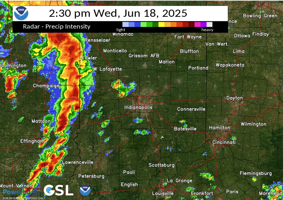
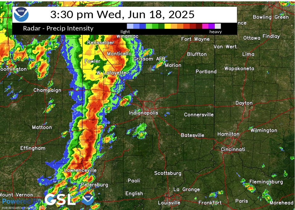
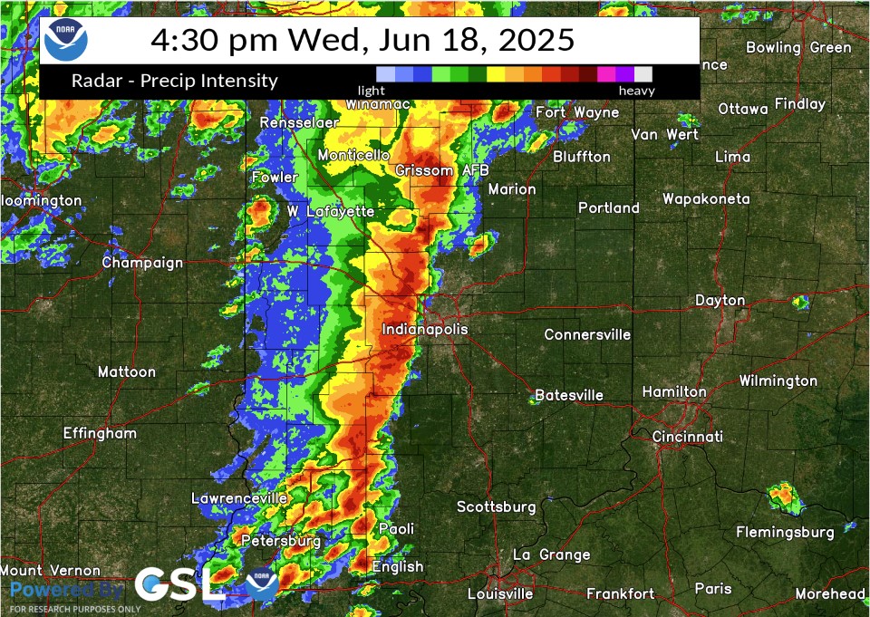
A line of strong to severe thunderstorms moved through central Indiana during the afternoon of June 18. The storms produced widespread wind damage, including downed trees and utility lines. Many power outages were reported. Two brief tornadoes caused damage west and northwest of Lafayette. These tornadoes showed signs of skipping along their path with significant straight line wind damage along a path stretching across much of the county. Only two touchdowns were definitive with only weak signs of circulation along the remainder of the damage path. |
Tornadoes
Select a tornado from the table to zoom into the track and view more information. The default table view is limited to 8 tracks, but can be scrolled by a mouse wheel or dynamically expanded. Additionally, the table can fill the entire window by clicking the small circular expanding arrow icon at the very top right of the table and returned to its original size by clicking the button again. The side information panel that opens over the map can be closed using the "X" on the upper right corner of the pop-up. Zoom into the map and click damage points to see detailed information and pictures from the surveys.
|
NOTE: times shown below are local to your device's time zone. |

The Enhanced Fujita (EF) Scale classifies tornadoes into the following categories:
| EF0 Weak 65-85 mph |
EF1 Moderate 86-110 mph |
EF2 Significant 111-135 mph |
EF3 Severe 136-165 mph |
EF4 Extreme 166-200 mph |
EF5 Catastrophic 200+ mph |
 |
|||||
| Tornadoes that fail to impact any ratable damage indicators on the EF-Scale are rated EF-Unknown (EF-U) | |||||
Storm Reports
Preliminary Local Storm Report...Summary
National Weather Service Indianapolis IN
..TIME... ...EVENT... ...CITY LOCATION... ...LAT.LON...
..DATE... ....MAG.... ..COUNTY LOCATION..ST.. ...SOURCE....
..REMARKS..
0748 AM Tstm Wnd Dmg 2 ENE Southport 39.67N 86.08W
06/18/2025 Marion IN Public
Large tree limb down (greater than 3 inch
diameter). Relayed by local media.
0233 PM Tstm Wnd Gst 2 E Gessie 40.08N 87.46W
06/18/2025 E60 MPH Vermillion IN Amateur Radio
0250 PM Tstm Wnd Dmg 3 NW Newtown 40.24N 87.19W
06/18/2025 Fountain IN Public
Multiple large tree branches and trunks
snapped. Times estimated from radar.
0255 PM Tstm Wnd Dmg Pine Village 40.45N 87.26W
06/18/2025 Warren IN Public
Tree damage over a few blocks and stop signs
blow over on the southern portion of Pine
Village. Twitter report. Time estimated from
radar.
0305 PM Tstm Wnd Dmg 2 SE Otterbein 40.47N 87.06W
06/18/2025 Tippecanoe IN Public
Live branch down over 2 inch diameter. Time
estimated from radar.
0311 PM Tstm Wnd Dmg 4 N West Lafayette 40.50N 86.92W
06/18/2025 Tippecanoe IN Public
Large tree limbs snapped and power poles
leaning. Time estimated.
0315 PM Tstm Wnd Dmg 2 W Purdue University 40.43N 86.95W
06/18/2025 Tippecanoe IN Public
Downed power lines on 26 west of Lafayette.
Report on Twitter. Time estimated.
0317 PM Tstm Wnd Dmg 3 SSW North Terre Haute 39.51N 87.38W
06/18/2025 Vigo IN Amateur Radio
50mph wind gust with several tree limbs
down. Sizes around 3 inches in diameter.
0318 PM Tstm Wnd Gst 3 N Indiana State Unive 39.51N 87.41W
06/18/2025 E60 MPH Vigo IN Amateur Radio
0319 PM Tstm Wnd Dmg 1 SSW North Terre Haute 39.52N 87.37W
06/18/2025 Vigo IN Public
12-14 inch diameter tree down.
0320 PM Tstm Wnd Dmg 3 W West Lafayette 40.46N 86.96W
06/18/2025 Tippecanoe IN Public
Large tree branches fell onto car and
townhomes. Very large tree uprooted. Power
lines down.
0321 PM Tstm Wnd Dmg Vincennes 38.68N 87.52W
06/18/2025 Knox IN Emergency Mngr
Numerous reports of trees down across
Vincennes. Time estimated.
0323 PM Tstm Wnd Dmg 2 S Oaktown 38.84N 87.44W
06/18/2025 Knox IN Public
tree limb down and numerous other downed
trees across the area. Time estimated from
radar.
0324 PM Tstm Wnd Dmg Indiana State Universit 39.47N 87.41W
06/18/2025 Vigo IN Amateur Radio
Numerous power outages reported.
0326 PM Tstm Wnd Dmg Vincennes University 38.69N 87.52W
06/18/2025 Knox IN Emergency Mngr
Tree blown down by thunderstorm winds.
0328 PM Tstm Wnd Gst 2 SW Purdue University 40.41N 86.94W
06/18/2025 M59 MPH Tippecanoe IN ASOS
Reports of tree damage nearby.
0331 PM Tstm Wnd Dmg Bruceville 38.76N 87.41W
06/18/2025 Knox IN Emergency Mngr
Trees blocking roads across town, trees on
powerlines and report of a tree on a home.
Time estimated from radar.
0332 PM Tstm Wnd Dmg 3 SSW Freelandville 38.82N 87.32W
06/18/2025 Knox IN Emergency Mngr
Trees and limbs down in the area. Time
estimated from radar.
0343 PM Tstm Wnd Dmg 3 N Center Point 39.47N 87.07W
06/18/2025 Clay IN Public
Tree damage near I-70 north of Center Point.
Report via Twitter.
0349 PM Tstm Wnd Dmg North Terre Haute 39.54N 87.36W
06/18/2025 Vigo IN Amateur Radio
Numerous trees down northern Vigo
County...no specific locations mentioned.
0350 PM Tstm Wnd Dmg Linton 39.04N 87.16W
06/18/2025 Greene IN Storm Chaser
Big tree down. A couple inches of water on
the road, not flowing.
0350 PM Tstm Wnd Dmg Bicknell 38.78N 87.31W
06/18/2025 Knox IN Emergency Mngr
Tree blown down from thunderstorm winds.
Report originated from EMA per caller.
0354 PM Tstm Wnd Dmg Montezuma 39.79N 87.37W
06/18/2025 Parke IN CO-OP Observer
10 to 15-inch diameter tree limb blown down
onto house.
0356 PM Tstm Wnd Dmg Vincennes 38.68N 87.51W
06/18/2025 Knox IN Amateur Radio
Tree or tree limb blown down by thunderstorm
winds.
0358 PM Tstm Wnd Dmg 2 N Indiana State Unive 39.50N 87.40W
06/18/2025 Vigo IN Amateur Radio
Thunderstorm winds blew down a 12-inch tree
limb on 9th Street between Indiana and
Delaware streets in Terre Haute.
0359 PM Flood 2 NE Vincennes Universi 38.71N 87.50W
06/18/2025 Knox IN Emergency Mngr
Tree or tree limb blown down by thunderstorm
winds.
0401 PM Tstm Wnd Gst 2 S Cloverdale 39.49N 86.80W
06/18/2025 M63 MPH Putnam IN Trained Spotter
0411 PM Tstm Wnd Gst 1 SW Farmersburg 39.25N 87.39W
06/18/2025 M65 MPH Sullivan IN CO-OP Observer
Measured at WTWO.
0412 PM Flood 3 N Devore 39.47N 86.78W
06/18/2025 Owen IN Amateur Radio
Flooding on roadway on US 231 between Owen
County line and Cloverdale.
0414 PM Tstm Wnd Gst 2 NW Gosport 39.36N 86.69W
06/18/2025 M71 MPH Owen IN Trained Spotter
Trees and power lines down as well.
0420 PM Tstm Wnd Gst 2 E Gosport 39.36N 86.62W
06/18/2025 E60 MPH Morgan IN Cocorahs
estimated 60 mph winds and pea size hail.
0420 PM Tstm Wnd Dmg 3 W Huron 38.72N 86.72W
06/18/2025 Martin IN Emergency Mngr
*** 1 INJ ***
Many trees down along Williams Road NE of
Shoals. One tree fell on a house injuring 1
person.
0424 PM Tstm Wnd Dmg 2 ENE Pittsboro 39.88N 86.42W
06/18/2025 Hendricks IN NWS Employee
Time estimated from radar. Lots of large
limbs down at this point. All pointed in
east direction.
0425 PM Tstm Wnd Dmg 1 ESE Plainfield 39.70N 86.38W
06/18/2025 Hendricks IN Trained Spotter
Multiple trees and limbs down on Stafford
Rd. Time estimated.
0427 PM Rain 1 SSE Rockville 39.76N 87.23W
06/18/2025 M1.07 Inch Parke IN CO-OP Observer
CO-OP Observer station ROKI3 Rockville.
0428 PM Tstm Wnd Gst 1 ENE Martinsville 39.43N 86.40W
06/18/2025 E60 MPH Morgan IN Trained Spotter
60 to 70 mph gusts estimated. 8.5 inch limbs
down.
0430 PM Tstm Wnd Dmg Brooklyn 39.54N 86.37W
06/18/2025 Morgan IN NWS Employee
Tree down blocking road in front of Brooklyn
Elementary School. Time is approximate.
0430 PM Tstm Wnd Dmg 5 SSW Sheridan 40.07N 86.26W
06/18/2025 Boone IN Public
Time estimated from radar. A large maple
tree was blown down by thunderstorm winds
with an estimated 4.5-foot diameter base.
The tree had health issues in the base but
was otherwise alive.
0430 PM Tstm Wnd Gst 6 ENE Whitestown 40.04N 86.25W
06/18/2025 M63 MPH Boone IN AWOS
0430 PM Tstm Wnd Dmg Speedway 39.79N 86.25W
06/18/2025 Marion IN Trained Spotter
1.5 foot diameter limb down from live walnut
tree. Time estimated.
0430 PM Tstm Wnd Dmg Kokomo 40.48N 86.14W
06/18/2025 Howard IN Public
multiple reports of trees down across town.
Time estimated.
0432 PM Tstm Wnd Gst 1 W Indiana University 39.17N 86.54W
06/18/2025 E70 MPH Monroe IN Trained Spotter
estimating 70 mph winds.
0432 PM Tstm Wnd Gst 1 SE Lebanon 40.05N 86.46W
06/18/2025 M55 MPH Boone IN Public
0432 PM Tstm Wnd Gst 1 SSW Indianapolis Int` 39.71N 86.30W
06/18/2025 M71 MPH Marion IN ASOS
0437 PM Tstm Wnd Gst 1 SE Lebanon 40.05N 86.46W
06/18/2025 M60 MPH Boone IN Public
Tree blown down by thunderstorm winds.
0440 PM Tstm Wnd Dmg Oolitic 38.89N 86.52W
06/18/2025 Lawrence IN Emergency Mngr
Trees and utility lines were blown down by
thunderstorm winds. Time estimated from
radar.
0440 PM Tstm Wnd Dmg 1 W Beech Grove 39.72N 86.10W
06/18/2025 Marion IN Public
Two tree tops broken off. Report via
Twitter. Time estimated from radar.
0440 PM Tstm Wnd Dmg 4 SW Indian Heights 40.39N 86.18W
06/18/2025 Tipton IN Public
Multiple trees damaged.
0442 PM Tstm Wnd Dmg 1 NNW Indianapolis 39.79N 86.15W
06/18/2025 Marion IN Broadcast Media
Time has been estimated from radar. Trees
and tree limbs were blown down by
thunderstorm winds on Alabama Street near 14
Street.
0442 PM Tstm Wnd Dmg 1 S Carmel 39.95N 86.11W
06/18/2025 Hamilton IN Local Official
Time is estimated from radar. A large tree
limb was blown down by thunderstorm winds
onto southbound lanes of Keystone Avenue
between 106th Street and 116th Street.
0443 PM Tstm Wnd Dmg Plainfield 39.71N 86.39W
06/18/2025 Hendricks IN Amateur Radio
Eight-inch diameter live tree down near Carr
Road and US 40 from thunderstorm winds.
0445 PM Tstm Wnd Dmg 1 SE Castleton 39.89N 86.04W
06/18/2025 Marion IN Public
Large tree uprooted on house near Fall Creek
and Castleton. Reported via Twitter. Time
estimated via radar.
0445 PM Tstm Wnd Dmg 1 W Warren Park 39.78N 86.07W
06/18/2025 Marion IN Public
Large tree and power lines down across
Ritter at Pleasant Run, Estunated 65 to 70
mph gusts.
0446 PM Non-Tstm Wnd Gst 2 SE Indianapolis Int`l 39.70N 86.26W
06/18/2025 M72 MPH Marion IN Mesonet
Mesonet station IN053 I-465 Kentucky Ave.
0448 PM Tstm Wnd Dmg Windfall 40.36N 85.96W
06/18/2025 Tipton IN Fire Dept/Rescue
Time estimated from radar. A large tree limb
split off about about 2 feet up from the
tree base on a tree with a health issue but
otherwise full of foliage. It caused minor
damage to a house on College Street.
0448 PM Tstm Wnd Gst 3 NE Carmel 40.01N 86.07W
06/18/2025 E50 MPH Hamilton IN Public
0449 PM Tstm Wnd Gst 4 ENE Paragon 39.41N 86.49W
06/18/2025 M65 MPH Morgan IN Amateur Radio
Near Browns Crossing.
0449 PM Tstm Wnd Gst Mooresville 39.62N 86.37W
06/18/2025 M67 MPH Morgan IN Amateur Radio
Near Mooresville.
0450 PM Tstm Wnd Dmg 1 SW New Whiteland 39.55N 86.12W
06/18/2025 Johnson IN Law Enforcement
Tree and power line down on Whiteland Rd at
75W. Relayed via Twitter. Time estimated
from radar.
0450 PM Tstm Wnd Dmg 4 SSE Warren Park 39.73N 86.02W
06/18/2025 Marion IN Public
Several 3 to 5 inch diameter limbs from
healthy catalpa tree down. Report via
Twitter. Time estimated from radar.
0451 PM Tstm Wnd Dmg 2 SE Beech Grove 39.70N 86.06W
06/18/2025 Marion IN Amateur Radio
Six-inch diameter tree limb down was blown
down at Arlington Avenue and Thompson Road
in Marion County.
0452 PM Rain 3 NE Carmel 40.01N 86.07W
06/18/2025 E0.50 Inch Hamilton IN Public
Estimate of the rain in the last 10 minutes.
0453 PM Tstm Wnd Gst Warren Park 39.78N 86.05W
06/18/2025 M67 MPH Marion IN Amateur Radio
0453 PM Tstm Wnd Dmg 2 W Cumberland 39.79N 85.99W
06/18/2025 Marion IN Public
Tree fallen onto two vehicles in Cumberland.
0454 PM Tstm Wnd Dmg 1 NE Story 39.11N 86.20W
06/18/2025 Brown IN Public
Time estimated from radar. A tree was down
onto utility lines with 3 to 5-inch diameter
branches broken off across State Road 135
due to thunderstorm winds.
0454 PM Tstm Wnd Gst Tipton 40.28N 86.04W
06/18/2025 M69 MPH Tipton IN Amateur Radio
Accompanied by 0.70-inch of rain in 10
minutes.
0455 PM Tstm Wnd Dmg Geist Reservoir 39.91N 85.98W
06/18/2025 Marion IN Trained Spotter
Large tree branch down. Report via Twitter.
0455 PM Tstm Wnd Dmg 2 W Avon 39.76N 86.43W
06/18/2025 Hendricks IN Amateur Radio
Several 2-3 live tree limbs across power
lines from thunderstorm winds.
0455 PM Tstm Wnd Dmg 2 S Danville 39.73N 86.52W
06/18/2025 Hendricks IN Amateur Radio
Several 2-3 live tree limbs across power
lines.
0455 PM Tstm Wnd Dmg 3 NE Warren Park 39.80N 86.01W
06/18/2025 Marion IN Amateur Radio
Seven-inch tree limb was blown down by
thunderstorm winds at 25th Street and Post
Road.
0459 PM Tstm Wnd Gst 4 E Southport 39.67N 86.04W
06/18/2025 M57 MPH Marion IN Amateur Radio
Near East Southport Road and 5 Points Road.
0500 PM Rain 3 NNW Prairieton 39.40N 87.50W
06/18/2025 M0.95 Inch Vigo IN Cocorahs
Cocorahs station IN-VG-19 West Terre Haute
5.0 SW.
0500 PM Tstm Wnd Dmg 4 SW Frankton 40.18N 85.82W
06/18/2025 Madison IN Public
Time estimated from radar. Considerable tree
limbs and tree debris in Camp Kikthawenund.
No damage or injuries.
0500 PM Tstm Wnd Dmg Paragon 39.39N 86.56W
06/18/2025 Morgan IN Amateur Radio
Twelve 12 tree down blocking southbound
SR67. Time is approximate.
0500 PM Tstm Wnd Dmg 3 SE Bethany 39.50N 86.34W
06/18/2025 Morgan IN Amateur Radio
Delayed report...time unknown...6-8-inch
diameter live tree down across the road from
thunderstorm winds.
0502 PM Tstm Wnd Dmg 1 ESE Spring Hill 39.83N 86.17W
06/18/2025 Marion IN Public
Numerous large oak trees down.
0506 PM Tstm Wnd Dmg Freetown 38.98N 86.13W
06/18/2025 Jackson IN Public
Multiple trees down on SR 135 from
thunderstorm winds.
0506 PM Tstm Wnd Dmg Woodville Hills 39.15N 86.39W
06/18/2025 Monroe IN Amateur Radio
Four inches of water across road.
0506 PM Tstm Wnd Dmg Woodville Hills 39.15N 86.39W
06/18/2025 Monroe IN Public
Sixteen-inch diameter healthy live tree
limbs broken and partially blocking roadway.
0507 PM Rain Unionville 39.22N 86.42W
06/18/2025 M1.20 Inch Monroe IN Cocorahs
0509 PM Hail 2 NW Linwood 40.22N 85.69W
06/18/2025 E0.50 Inch Madison IN Public
Report from mPING: Half-inch (0.50 in.).
0510 PM Tstm Wnd Dmg 3 ESE Mccordsville 39.90N 85.88W
06/18/2025 Hancock IN Amateur Radio
Six-inch tree limb blocking SR 234 at 400
West. Time approximated from radar.
0512 PM Tstm Wnd Dmg Edgewood 40.10N 85.73W
06/18/2025 Madison IN Trained Spotter
Time estimated from radar. Several trees and
branches down in town. Two streets blocked.
0512 PM Tstm Wnd Gst 1 NW Spurgeons Corner 39.08N 86.16W
06/18/2025 M62 MPH Brown IN Public
0515 PM Tstm Wnd Gst 1 NW Stone Head 39.14N 86.17W
06/18/2025 E70 MPH Brown IN Public
3 to 5 inch diamater tree branches down.
0516 PM Tstm Wnd Dmg 2 SE Nashville 39.19N 86.22W
06/18/2025 Brown IN Amateur Radio
Near Abe Martin Road in Brown County State
Park...tree blown down on car with people
trapped.
0516 PM Hail 1 NE Alexandria 40.26N 85.67W
06/18/2025 M1.00 Inch Madison IN Public
Report from mPING: Quarter (1.00 in.).
0517 PM Tstm Wnd Gst Spurgeons Corner 39.07N 86.15W
06/18/2025 M67 MPH Brown IN Public
Multiple tree branches down.
0518 PM Tstm Wnd Dmg Morristown 39.68N 85.70W
06/18/2025 Shelby IN Law Enforcement
Time estimated from radar. Tree into a
residence 200 Blk W Broadway, no injuries.
Multiple small limbs down and a few larger
limbs, traffic is not affected.
0519 PM Tstm Wnd Dmg 3 SE Fortville 39.91N 85.82W
06/18/2025 Hancock IN Amateur Radio
Near CR 50 W and CR 800 N...6 live trees
were blown down.
0520 PM Hail 1 NE Alexandria 40.27N 85.67W
06/18/2025 M1.50 Inch Madison IN Public
Report from mPING: Ping Pong Ball (1.50
in.).
0521 PM Tstm Wnd Dmg Columbus 39.21N 85.91W
06/18/2025 Bartholomew IN Public
large tree down, fence blown over. Time
estimated by radar. Report via Twitter.
0524 PM Tstm Wnd Dmg Columbus 39.21N 85.91W
06/18/2025 Bartholomew IN Emergency Mngr
Time estimated from radar. Multiple trees
and wires down across the county with a few
roads blocked. Report of one tree on the
roof of a house in Columbus with no
injuries. Multiple power outages. Report of
a tree on top of four to six unoccupied cars
in Columbus with no injuries reported.
0524 PM Hail 1 NW Alexandria 40.27N 85.69W
06/18/2025 E1.50 Inch Madison IN Public
Report from mPING: Ping Pong Ball (1.50
in.).
0525 PM Hail Summitville 40.33N 85.65W
06/18/2025 M1.25 Inch Madison IN Public
Report from mPING: Half Dollar (1.25 in.).
0527 PM Tstm Wnd Dmg 1 SE Edinburgh 39.34N 85.96W
06/18/2025 Bartholomew IN Trained Spotter
Large billboard blow over. Measured gust to
just over 60 mph.
0528 PM Tstm Wnd Dmg 1 W Arlington 39.64N 85.59W
06/18/2025 Rush IN Law Enforcement
Tree and utility lines were blown down by
thunderstorm winds. Relayed by EMA.
0529 PM Tstm Wnd Dmg Royerton 40.26N 85.37W
06/18/2025 Delaware IN Public
Downed power lines and tree branches 3 to
3.5 inches in diameter along with various
debris was caused by thunderstorm winds.
0529 PM Tstm Wnd Gst 2 SW Royerton 40.24N 85.40W
06/18/2025 M73 MPH Delaware IN ASOS
0529 PM Tstm Wnd Dmg Taylorsville 39.30N 85.95W
06/18/2025 Bartholomew IN Amateur Radio
Two 18-inch diameter live trees sheared off
approximately 50 feet up and fell on a
house.
0530 PM Tstm Wnd Dmg 1 WNW Seymour 38.96N 85.90W
06/18/2025 Jackson IN Public
Time is estimated from radar. A tree or
large tree branch was blown down on 6th
Street near Emerson Elementary School.
Relayed by WYMT-TV.
0530 PM Tstm Wnd Gst 4 NW Ball State Univers 40.24N 85.45W
06/18/2025 M79 MPH Delaware IN Trained Spotter
Time is estimated from radar. Winds hit a
mobile home park in Muncie, uprooting a tree
halfway up that fell on a mobile home. No
injuries.
0530 PM Tstm Wnd Dmg 1 WSW Rushville 39.61N 85.46W
06/18/2025 Rush IN Emergency Mngr
Tree into a house at Market and Ivy in
Rushville. No injuries. Multiple trees and
power lines down across the county.
0530 PM Tstm Wnd Dmg 1 NNW Ball State Univer 40.21N 85.42W
06/18/2025 Delaware IN Public
Time estimated from radar. Large tree branch
was blown down by thunderstorm winds.
0530 PM Tstm Wnd Dmg 3 SSW Prairie Creek Res 40.09N 85.31W
06/18/2025 Delaware IN Amateur Radio
Time estimated from radar. Live 14-inch
diameter tree was blown down by thunderstorm
winds onto a house that did not sustain
damage.
0531 PM Tstm Wnd Dmg 2 N Ball State Universi 40.22N 85.41W
06/18/2025 Delaware IN Public
rAt least 1 tree uprooted onto a power line
on S Dill St near Washington St At least 3
trees had limbs broken off across from White
River Blvd between W Jackson St and Wheeling
Ave. At least 2 trees had limb damage in
Norwood neighborhood 2mi NW of Downtown
Muncie. One tree was broken at the base in
the same Norwood neighborhood.
0536 PM Tstm Wnd Dmg 1 NE Crothersville 38.81N 85.83W
06/18/2025 Jackson IN Public
Time estimated from radar. A tree was split
about 10 feet up that may have been
previously compromised.
0542 PM Tstm Wnd Dmg 1 N Farmland 40.21N 85.13W
06/18/2025 Randolph IN Public
Time estimated from radar. Wind damage
occurred to a front yard tree and a garage.
0544 PM Tstm Wnd Gst 4 N Glenwood 39.69N 85.30W
06/18/2025 E60 MPH Rush IN Trained Spotter
0546 PM Tstm Wnd Dmg 5 W Columbus 39.22N 86.01W
06/18/2025 Bartholomew IN Amateur Radio
Twenty-inch diameter live tree was blown
down by thunderstorm winds.
0547 PM Tstm Wnd Dmg 1 SSE Ball State Univer 40.18N 85.40W
06/18/2025 Delaware IN Amateur Radio
Four-inch live tree limbs were blown down
into the street by thunderstorm winds at 8th
Street just east of Port Street.
0550 PM Tstm Wnd Dmg 3 N Farmland 40.24N 85.13W
06/18/2025 Randolph IN Amateur Radio
Tree down on utility lines and hanging into
road.
0552 PM Tstm Wnd Dmg 2 NE Columbus 39.23N 85.88W
06/18/2025 Bartholomew IN Amateur Radio
Twelve-inch diameter pine tree split in
half.
0600 PM Hail 1 S Millhousen 39.20N 85.43W
06/18/2025 M0.75 Inch Decatur IN Public
Report from mPING: Dime (0.75 in.).
0649 PM Rain Tipton 40.28N 86.04W
06/18/2025 M1.22 Inch Tipton IN Public
0800 PM Rain Spencer 39.28N 86.77W
06/18/2025 M1.49 Inch Owen IN CO-OP Observer
CO-OP Observer station SPNI3 Spencer.
0856 PM Rain 3 WSW Whitehall 39.15N 86.62W
06/18/2025 M1.05 Inch Monroe IN ASOS
ASOS station KBMG Bloomington.
0900 PM Rain 2 SW Avoca 38.89N 86.57W
06/18/2025 M1.20 Inch Lawrence IN Mesonet
Mesonet station FPCI3 FELDUN-PURDUE AGRI
BEDFORD 5 WNW IN US.
0900 PM Rain 2 SW Avoca 38.89N 86.57W
06/18/2025 M1.20 Inch Lawrence IN Mesonet
Mesonet station FPCI3 FELDUN-PURDUE AGRI
BEDFORD 5 WNW IN US.
0909 PM Rain 3 N Bartlettsville 39.01N 86.44W
06/18/2025 M1.08 Inch Monroe IN Mesonet
Mesonet station HDRI3 2.9 N Bartlettsville.
0909 PM Rain 3 N Bartlettsville 39.01N 86.44W
06/18/2025 M1.08 Inch Monroe IN Mesonet
Mesonet station HDRI3 9 NE Oolitic.
0910 PM Rain 3 ESE Sullivan 39.08N 87.35W
06/18/2025 M0.95 Inch Sullivan IN Mesonet
Mesonet station SULI3 Sullivan Raws.
0910 PM Rain 1 NW Ellettsville 39.24N 86.63W
06/18/2025 M1.08 Inch Monroe IN Mesonet
Mesonet station AR596 Elletsville.
0915 PM Rain Fairview Park 39.69N 87.41W
06/18/2025 M1.07 Inch Vermillion IN Mesonet
Mesonet station EW5179 Clinton.
0915 PM Rain 4 NNW Whitestown 40.04N 86.37W
06/18/2025 M1.34 Inch Boone IN Mesonet
Mesonet station GW0557 Lebanon.
0916 PM Rain 1 SSW Lafayette 40.39N 86.88W
06/18/2025 M1.61 Inch Tippecanoe IN Mesonet
Mesonet station FW7271 Lafayette.
0925 PM Rain 4 NNW Mitchell 38.79N 86.50W
06/18/2025 M0.90 Inch Lawrence IN Mesonet
Mesonet station FW2670 Mitchell.
0925 PM Rain 2 NNW Avon 39.79N 86.40W
06/18/2025 M0.96 Inch Hendricks IN Mesonet
Mesonet station AW010 AVON.
0925 PM Rain 1 S Millhousen 39.20N 85.44W
06/18/2025 M1.16 Inch Decatur IN Mesonet
Mesonet station FW6569 Millhousen.
0926 PM Rain 1 NNW Greencastle 39.66N 86.85W
06/18/2025 M0.94 Inch Putnam IN Mesonet
Mesonet station FW3934 Greencastle.
0929 PM Rain 2 S Whitehall 39.14N 86.57W
06/18/2025 M0.90 Inch Monroe IN Mesonet
Mesonet station GW2070 BLOOMINGTON.
0929 PM Rain 1 ESE New Market 39.95N 86.90W
06/18/2025 M0.93 Inch Montgomery IN Mesonet
Mesonet station CRFRD 1 ESE New Market.
0929 PM Rain 2 SW Judson 39.79N 87.17W
06/18/2025 M1.17 Inch Parke IN Mesonet
Mesonet station GW2508 Nyesville.
0929 PM Rain 1 WNW Judson 39.82N 87.15W
06/18/2025 M1.27 Inch Parke IN Mesonet
Mesonet station GW2510 Judson.
0930 PM Rain 1 WSW Lake Santee 39.40N 85.32W
06/18/2025 M0.91 Inch Decatur IN Mesonet
Mesonet station EW3061 Lake Santee.
0930 PM Rain 3 W Mecca 39.73N 87.39W
06/18/2025 M0.95 Inch Vermillion IN Mesonet
Mesonet station HLLDL 3 NNE Fairview Park.
0930 PM Rain 1 NNE Rockville 39.77N 87.23W
06/18/2025 M1.00 Inch Parke IN Mesonet
Mesonet station AT399 ROCKVILLE.
Radar
Selected images from the event. A loop is available.
 |
 |
 |
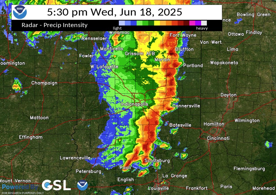 |
| Radar at 2:30 PM EDT | Radar at 3:30 PM EDT | Radar at 4:30 PM EDT | Radar at 5:30 PM EDT |
Environment
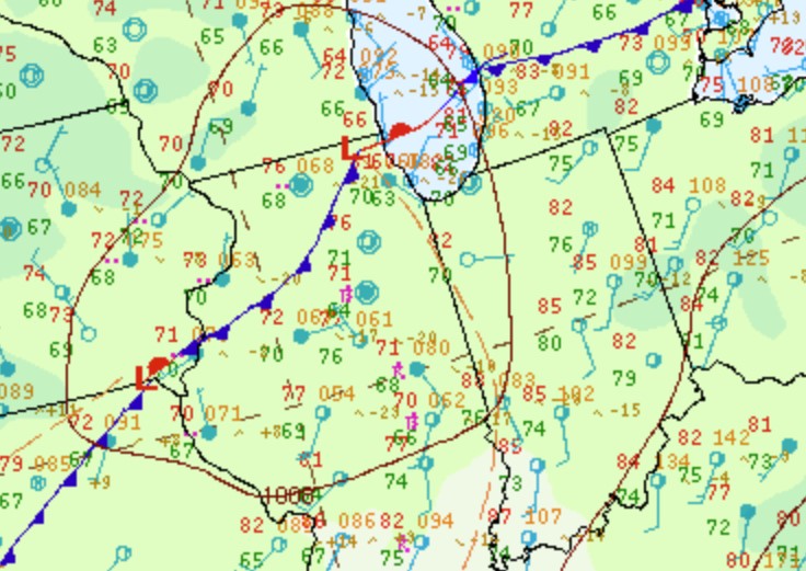
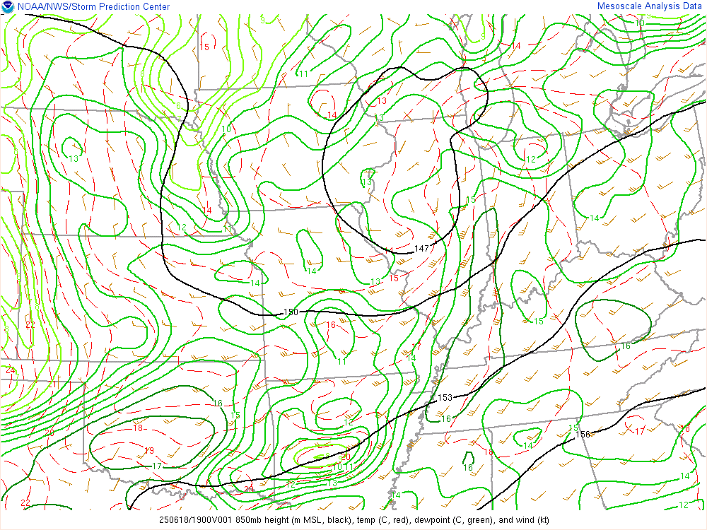
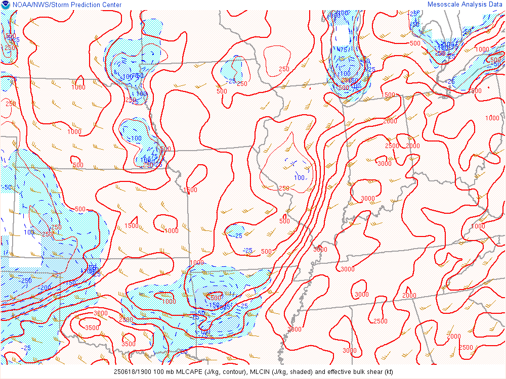
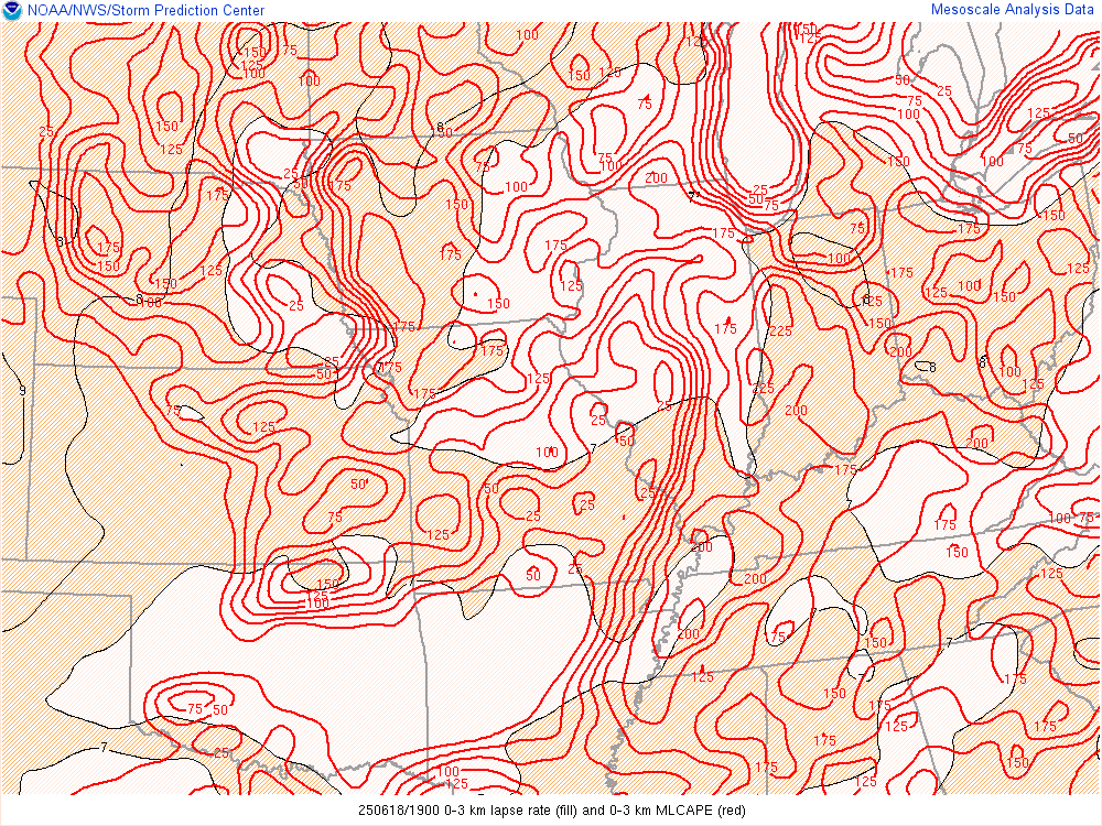
Very warm and humid air led to high instability across central Indiana during the afternoon. Good shear was present as well. With the influence of a Mesoscale Convective Vortex (MCV), a line of storms developed in these conditions, producing severe storms.
 |
 |
 |
| Figure 1: Surface Map (Zoomed into the area) at 2 PM EDT | Figure 2: 850mb at 3:00 PM EDT | Figure 3: 500mb at 3:00 PM EDT |
 |
 |
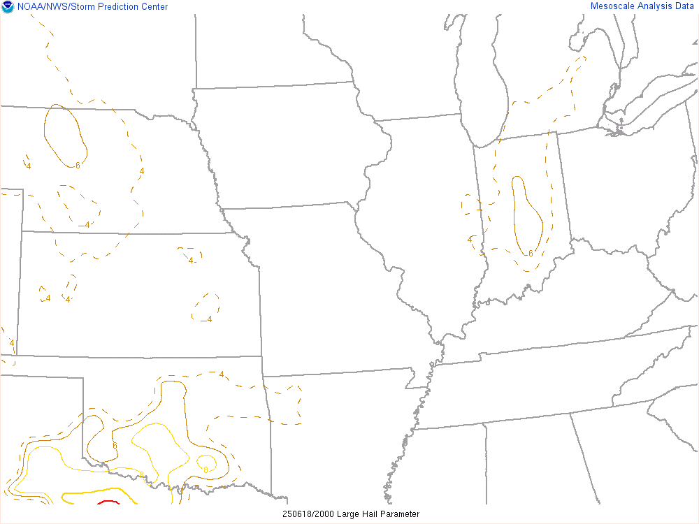 |
| Figure 4: Mixed Layer CAPE (MLCAPE) and Effective Shear at 3:00 PM EDT | Figure 5: Lapse Rates and 0-3km CAPE at 3 PM | Figure 6: Large Hail Parameter at 4 PM EDT |
Additional Information
The Forecast
 |
 |
 |
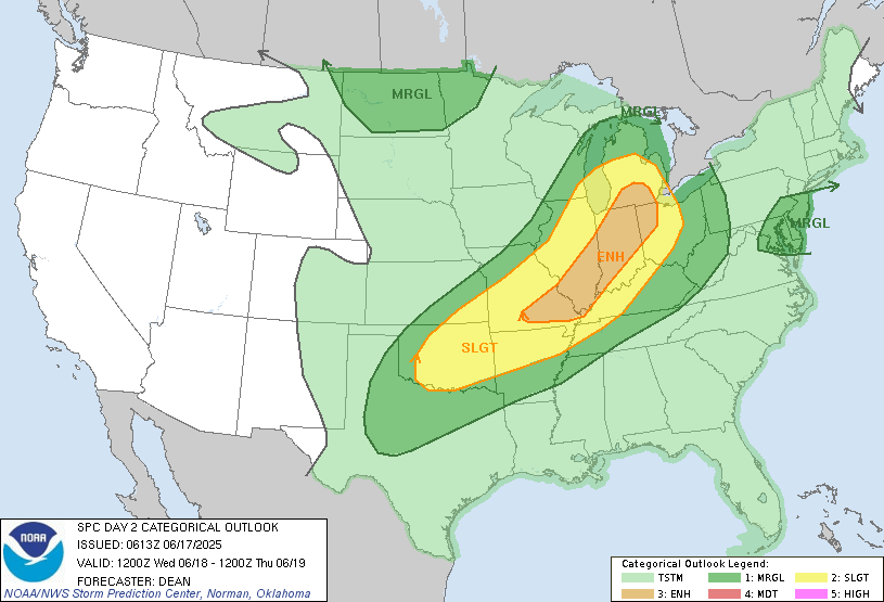 |
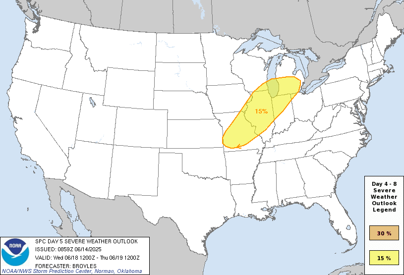
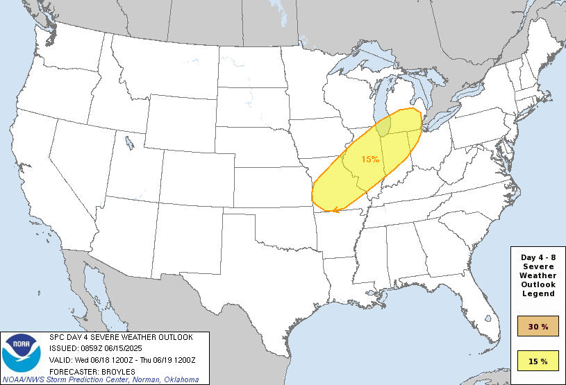
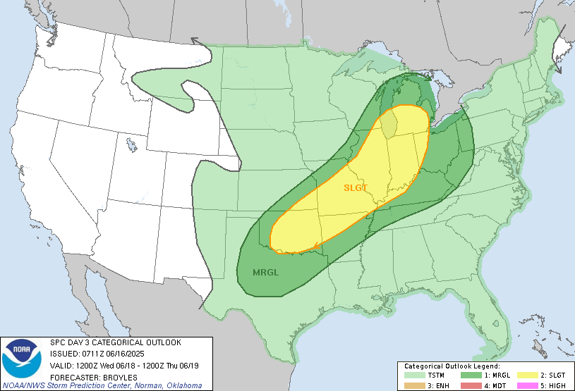
| SPC Day 5 Categorical Outlook | SPC Day 4 Probabilistic Outlook | SPC Day 3 Categorical Outlook | SPC Day 2 Categorical Outlook |
 |
 |
 |
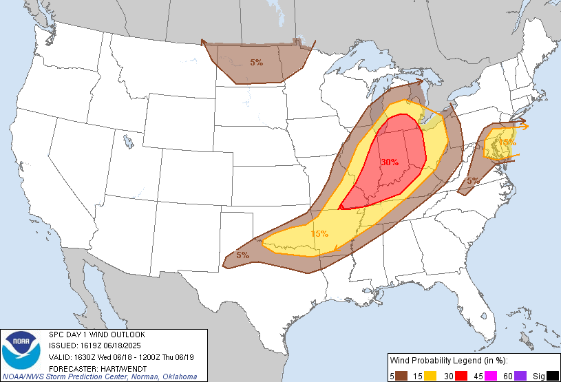 |
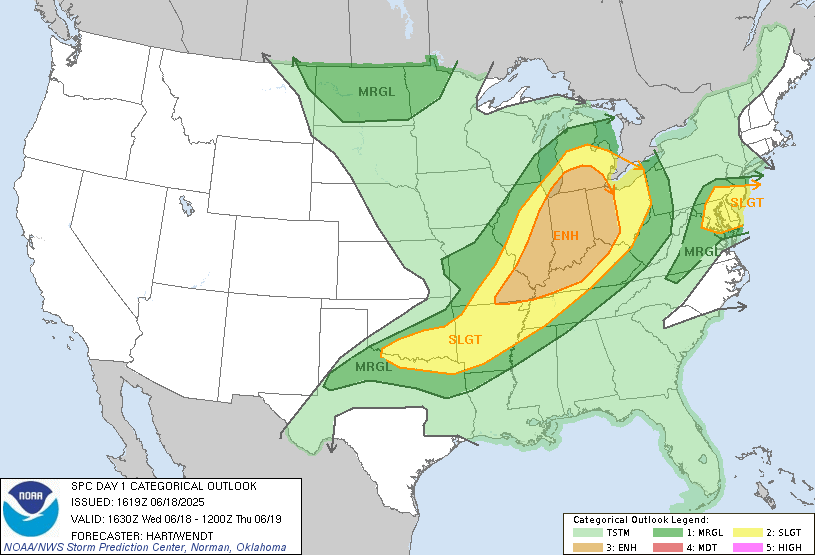
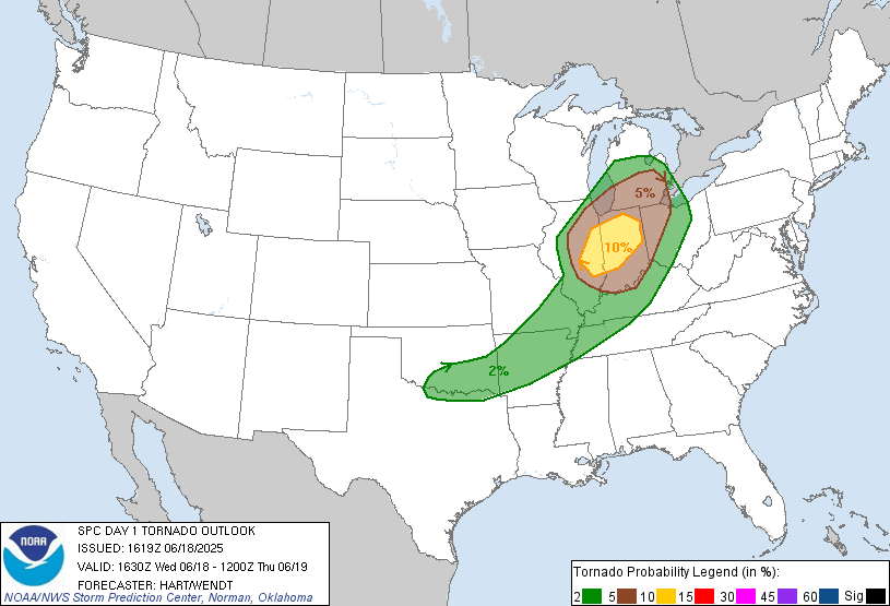
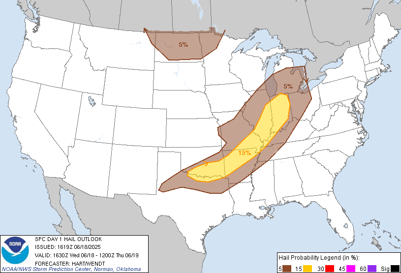
| SPC Day 1 Categorical Outlook | SPC Day 1 Tornado Outlook | SPC Day 1 Hail Outlook | SPC Day 1 Wind Outlook |
 |
Media use of NWS Web News Stories is encouraged! Please acknowledge the NWS as the source of any news information accessed from this site. |
|

