Overview
|
An outbreak of severe thunderstorms brought extreme winds, very large hail, and tornadoes across much of southern North Dakota from the late afternoon into the nighttime hours on Friday, June 20, 2025. The environment was exceptionally favorable for severe weather, with potential for tornadoes and significant damaging wind gusts. A Severe Thunderstorm Watch was issued for parts of southwest and south central North Dakota at 3:45 PM CDT as thunderstorms were developing in eastern Montana. Severe wind gusts around 60 mph were reported in southwest North Dakota from Dickinson to Bowman during the 6 to 7 PM MDT hour. Thereafter, storms grew into a more pronounced line as they moved east and began accelerating. Automated weather observation sites soon began reporting extremely strong wind gusts, including a 94 mph gust at 7:17 PM MDT at the North Dakota Agricultural Weather Network (NDAWN) station 10 miles northwest of Elgin. Meanwhile, a discrete supercell developed just south of Jamestown, and produced hail up to 3 inches in diameter as it moved north into the city. This storm then slowly moved to the northeast and produced a brief tornado a few miles east of Jamestown. Then at around 9 PM CDT, a larger and more damaging tornado formed 2 miles east-northeast of Spiritwood and moved into Barnes County. A second supercell then formed south of the initial storm, moving southeast through southern Stutsman and northern LaMoure Counties. This storm produced a tornado near Adrian and another north of Verona. The line of storms to the west continued to strengthen, producing a wide swath of 80 to 100 mph wind gusts as it moved through south central North Dakota from around 9 to 11 PM CDT, resulting in extensive tree and structural damage. The strongest observed gust was 101 mph at an NDAWN station 5 miles northwest of Linton. There were also several tornadoes produced by the intense line of storms. This includes 2 tornadoes rated EF-1:
and 1 tornado rated EF-2:
Other unrated tornadoes were reported 6 miles northwest of New Salem, 12 miles north of Verona, and 4 miles southeast of Washburn. As the main line of storms moved into eastern North Dakota, a phenomenon known as a "Mesoscale Convective Vortex" developed on the northern end of the bowing line of storms. This feature is essentially a small-scale low pressure system that developed due to the intensity of the line of storms. The Mesoscale Convective Vortex that developed in this event was uniquely intense, and brought 1 to 2 hours of hurricane force winds to areas east of Highway 83 and between Highway 200 and Interstate 94. The strongest measured gust associated with the Mesoscale Convective Vortex in central North Dakota was 99 mph in northern Kidder County. All tornado ratings remain preliminary. New information will be added to this page as it is received and reviewed.
|
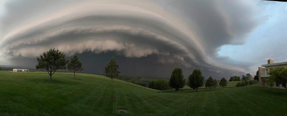
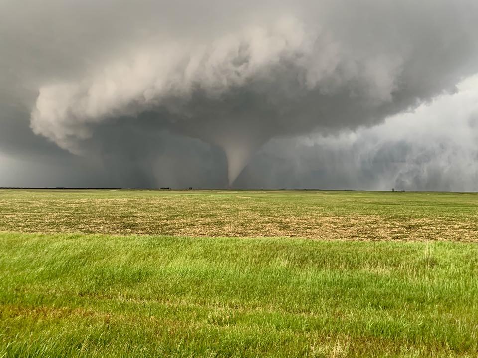 Tornado just south of Spiritwood. Photo courtesy of Eric Freitag. |
Photos & Video
Tornadoes
|
.jpg) |
 |
 |
| Tornado Just South of Spiritwood (Photo Courtesy of Eric Freitag) |
Tornado Near Verona (Photo Courtesy of Dylan Hollingsworth) |
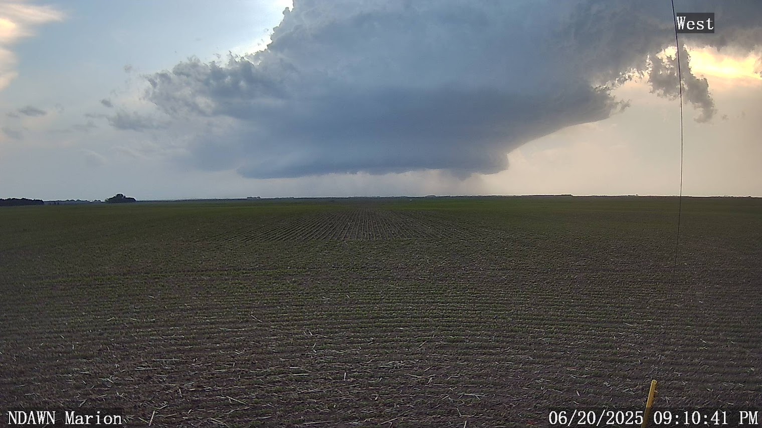
Tornado Near Marion (Photo Courtesy of NDAWN) |
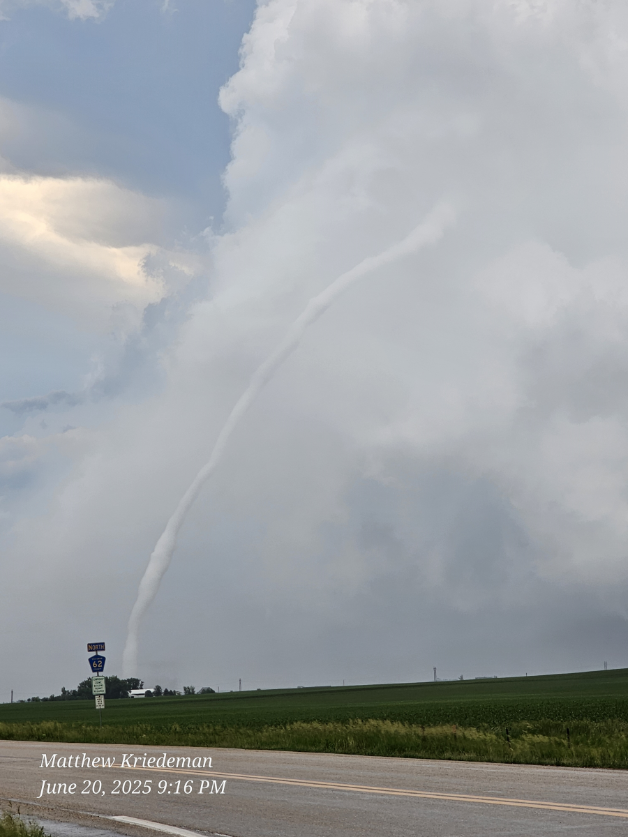
Tornado Near Spiritwood (Photo Courtesy of Matthew Kriedman) |
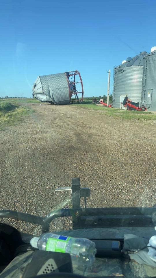
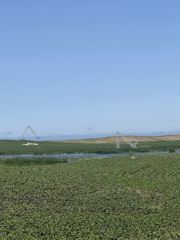
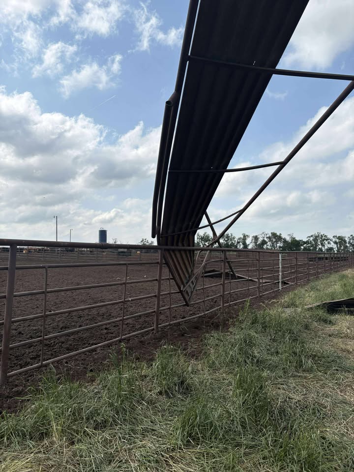
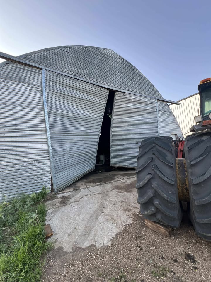
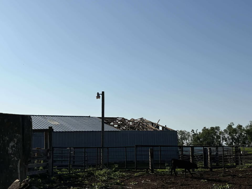
Wind Damage
 |
 |
 |
 |
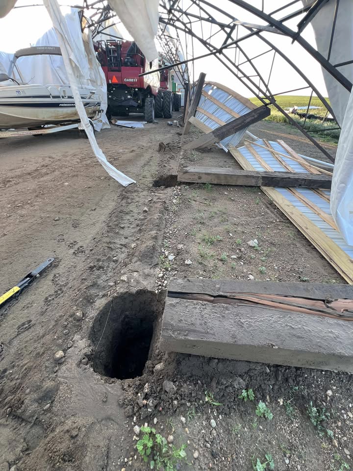
| Wind Damage Near Spiritwood (Photo Courtesy of Megan Scott Chapin) |
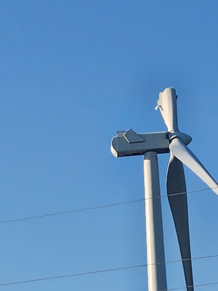
Turbine Wind Damage 2 West of Courtenay (Photo Courtesy of LaDon Bubba Smith) |
Tree Damage in Bismarck (Photo Courtesy of Bismarck Public Works) |
Tree Damage Kensal (Photo Courtesy of LaDon Bubba Smith) |
Storm Photos
 |
 |
 |
| Line of storms as it approached Bismarck (University of Mary) |
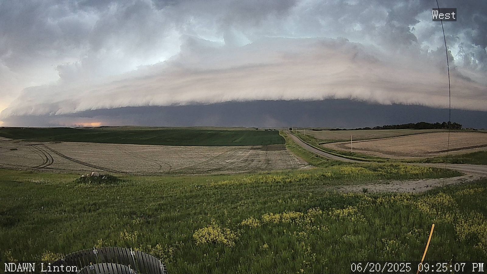
Line of storms as it approached Linton (NDAWN) |
Line of storms as it approached Mott (NDAWN) |
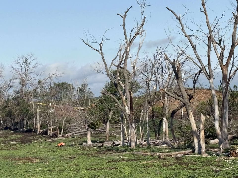
Tornado Damage
Photos are from the EF-1 tornado near Medina, ND.
 |
 |
 |
 |
| Tornado Damage (Photo Courtesy of Bonnie Hoffman) |
Tornado Damage (Photo Courtesy of Bonnie Hoffman) |
Tornado Damage (Photo Courtesy of Jenny Schlect) |
Tornado Damage (Photo Courtesy of Bonnie Hoffman) |
 |
 |
 |
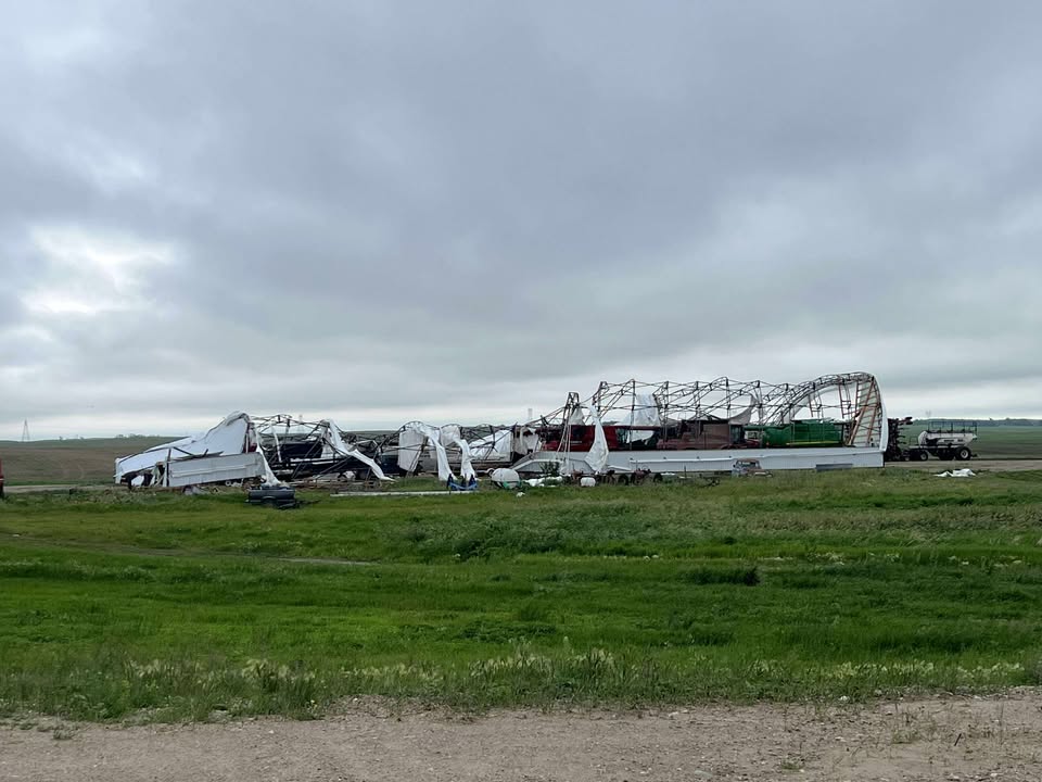 |
| Tornado Damage (Photo Courtesy of Jenny Schlect) |
Tornado Damage (Photo Courtesy of Jenny Schlect) |
Tornado Damage (Photo Courtesy of Jenny Schlect) |
Tornado Damage (Photo Courtesy of Bonnie Hoffman) |
Hail
 |
 |
 |
 |
| Hail 3 North of Jamestown (Photo Courtesy of Brooke George) |
Hail North Jamestown (Photo Courtesy of Mandi Quigley) |
Hail in Montpelier (Photo Courtesy of Eric Lubenow) |
Hail Southwest Jamestown (Photo Courtesy of Nick Rowley) |
Storm Reports
..TIME... ...EVENT... ...CITY LOCATION... ...LAT.LON...
..DATE... ....MAG.... ..COUNTY LOCATION..ST.. ...SOURCE....
..REMARKS..
1100 PM Flood Wilton 47.16N 100.78W
06/20/2025 McLean ND Public
Wilton Ambulance driver reported flooding in
the streets and numerous basements flooded.
Some of the streets have water that is knee
deep. Port o potties overturned in the
ponds.
0655 PM Hail 7 E Fairfield 47.19N 103.08W
06/20/2025 E1.00 Inch Billings ND Public
0750 PM Hail Jamestown 46.91N 98.71W
06/20/2025 M1.50 Inch Stutsman ND Trained Spotter
0751 PM Hail 3 S Jamestown 46.87N 98.71W
06/20/2025 E1.00 Inch Stutsman ND Public
Report from mPING: Quarter (1.00 in.).
0759 PM Hail 1 SE Jamestown 46.90N 98.70W
06/20/2025 M2.00 Inch Stutsman ND Public
Report from mPING: Hen Egg (2.00 in.).
0800 PM Hail Jamestown 46.91N 98.71W
06/20/2025 E1.75 Inch Stutsman ND Trained Spotter
hail still ongoing. damage to car
windshield.
0805 PM Hail Jamestown 46.91N 98.71W
06/20/2025 M2.50 Inch Stutsman ND NWS Employee
Ongoing at time of report.
0807 PM Hail 1 SE Jamestown 46.90N 98.70W
06/20/2025 E3.00 Inch Stutsman ND Public
Report from mPING: Tea Cup (3.00 in.).
0825 PM Hail 2 N Jamestown 46.94N 98.71W
06/20/2025 M3.00 Inch Stutsman ND Public
Public phone call. Picture also sent vis
email.
0920 PM Hail Marion 46.61N 98.33W
06/20/2025 M2.00 Inch LaMoure ND Emergency Mngr
Large hail during tornado warned storm.
0700 AM Rain 6 NE Emrick 47.65N 99.40W
06/21/2025 M1.20 Inch Wells ND Cocorahs
Cocorahs station ND-WL-5 Cathay 6.5 N.
0829 AM Rain Hensler 47.26N 101.08W
06/21/2025 M1.48 Inch Oliver ND Trained Spotter
0927 AM Rain Bremen 47.75N 99.39W
06/21/2025 M1.90 Inch Wells ND Public
Relayed through broadcast media.
0202 PM Rain 5 NNW Regan 47.22N 100.57W
06/21/2025 M2.70 Inch Burleigh ND Public
0840 PM Tornado 6 NW New Salem 46.92N 101.49W
06/20/2025 Morton ND Public
Photo of tornado from public matches up with
reports of sightings from New Salem area,
and corroborated with radar data. No damage
reported.
0840 PM Tornado 4 WSW Spiritwood 46.91N 98.57W
06/20/2025 Stutsman ND Storm Chaser
Initial touchdown.
0850 PM Tornado 2 ENE Spiritwood 46.94N 98.46W
06/20/2025 Stutsman ND Public
0910 PM Tornado 5 WNW Adrian 46.63N 98.64W
06/20/2025 LaMoure ND Public
Brief tornado touched down near Stutsman and
LaMoure County line. NDAWN Marion station
webcam had visible funnel cloud around this
time, and public submitted video of dusty
ground circulation from the location of this
report. No damage reported and tornado was
not long lived.
1010 PM Tornado 12 N Verona 46.53N 98.10W
06/20/2025 LaMoure ND Public
Social media report and pictures of a brief
tornado north of Verona and west of Highway
1.
0825 PM Tstm Wnd Dmg 4 WNW Heart Butte Dam 46.62N 101.88W
06/20/2025 Grant ND Public
Damage relayed from public through social
media on north side of Lake Tschida. Damage
includes camper tipped on its side, pontoon
completely flipped, downed trees, wooden
swingset tipped over. Time estimated from
radar.
0828 PM Tstm Wnd Dmg Glen Ullin 46.82N 101.83W
06/20/2025 Morton ND Public
Downed cottonwood. Relayed via social media
with a radar estimated time.
0830 PM Tstm Wnd Dmg Stanton 47.32N 101.38W
06/20/2025 Mercer ND Public
Social media report of shingles and siding
off.
0840 PM Tstm Wnd Dmg 9 W Hannover 47.12N 101.62W
06/20/2025 Oliver ND Public
Photo relayed through social media of
multiple trees broken. Time estimated from
radar.
0840 PM Tstm Wnd Dmg 1 SSE Sweet Briar Lake 46.85N 101.24W
06/20/2025 Morton ND Public
Photos of downed trees on Highway 10 relayed
through social media. Time estimated from
radar.
0845 PM Tstm Wnd Dmg 7 SE Almont 46.66N 101.38W
06/20/2025 Morton ND Fire Dept/Rescue
Report from New Salem Fire Department of
multiple power lines down. Time estimated
from radar.
0845 PM Tstm Wnd Dmg 4 N New Salem 46.91N 101.41W
06/20/2025 Morton ND Public
Public relayed photos of large tree snapped
towards the base, and another tree that fell
onto a house. Time estimated from radar.
0855 PM Tstm Wnd Dmg 6 NNW Sweet Briar Lake 46.95N 101.28W
06/20/2025 Morton ND Trained Spotter
About a mile of power lines down along
County Road 84. Time estimated from radar.
0905 PM Tstm Wnd Dmg 1 E Bismarck 46.81N 100.75W
06/20/2025 Burleigh ND NWS Employee
Large evergreen tree blown over near Rosser
Ave and 26th Street.
0909 PM Tstm Wnd Dmg 8 N Mandan 46.94N 100.90W
06/20/2025 Burleigh ND Public
Social media report of downed trees near
Double Ditch State Recreation Area. Time
estimated based on radar.
0915 PM Tstm Wnd Dmg 3 NNE Bismarck 46.84N 100.76W
06/20/2025 Burleigh ND Trained Spotter
Large tree damage.
0915 PM Tstm Wnd Dmg 3 SSW Bismarck 46.77N 100.80W
06/20/2025 Burleigh ND Public
Numerous tree limbs down.
0915 PM Tstm Wnd Dmg Bismarck 46.81N 100.78W
06/20/2025 Burleigh ND Public
Tree limbs down in Hillview area.
0918 PM Tstm Wnd Dmg 2 S Lincoln 46.73N 100.69W
06/20/2025 Burleigh ND Public
*** 1 INJ ***
Social media report and photos of a large
shop destroyed and blown across the road
into neighbors property. A lot of debris in
this yard. Garage door damaged with wood
debris blown through it. Mature trees ripped
and snapped in half. Four wheeler moved 100
yards. Damage is consistent with wind speeds
of 100 to 110 mph. One injury reported. Time
estimated based on radar.
0920 PM Tstm Wnd Dmg 1 N Baldwin 47.05N 100.75W
06/20/2025 Burleigh ND Public
Photos sent of damage near Baldwin. 40x60
pole barn was mostly destroyed and debris
was blown about 300 feet east-northeast from
the building site. Most posts from the pole
barn were pulled out of the ground but the
equipment in the barn sustained very little
damage. Damage is consistent with wind
speeds of 90 to 100 mph. Time estimated from
radar.
0936 PM Tstm Wnd Dmg Hazelton 46.48N 100.28W
06/20/2025 Emmons ND Public
Social media report of a few trees down and
power outage for Hazelton. Several branches
also down. Time estimated based on radar.
1000 PM Tstm Wnd Dmg 1 S Dawson 46.86N 99.75W
06/20/2025 Kidder ND Public
Facebook post from Prairie Meadows Events
shows damage at the venue. A variety of
large trees are down, including a very large
tree split at the base. Time estimated from
radar.
1040 PM Tstm Wnd Dmg 5 SE Buchanan 47.01N 98.74W
06/20/2025 Stutsman ND Trained Spotter
Half of shop roof torn off and siding ripped
off house. Radar estimated time.
1055 PM Tstm Wnd Dmg Kensal 47.30N 98.73W
06/20/2025 Stutsman ND Public
Photos relayed through social media from
city of Kensal of large trees uprooted. Time
estimated from radar.
0715 PM Tstm Wnd Gst 3 W Buffalo Springs 46.17N 103.30W
06/20/2025 M58 MPH Bowman ND AWOS
AWOS station KBWW Bowman Airport.
0730 PM Tstm Wnd Gst 9 SSW New England 46.43N 102.97W
06/20/2025 E60 MPH Slope ND Trained Spotter
0742 PM Tstm Wnd Gst 5 S Dickinson 46.80N 102.80W
06/20/2025 M58 MPH Stark ND ASOS
ASOS station KDIK Dickinson Airport.
0753 PM Tstm Wnd Gst 1 NNW Hettinger 46.02N 102.65W
06/20/2025 M59 MPH Adams ND ASOS
ASOS station KHEI Hettinger Airport.
0755 PM Tstm Wnd Gst 5 S Lefor 46.60N 102.55W
06/20/2025 M63 MPH Hettinger ND Public
weather station.
0757 PM Tstm Wnd Gst 1 NNW Hettinger 46.02N 102.65W
06/20/2025 M61 MPH Adams ND ASOS
ASOS station KHEI Hettinger Airport.
0805 PM Tstm Wnd Gst 1 NNE Mott 46.38N 102.32W
06/20/2025 M61 MPH Hettinger ND Mesonet
10m wind gust Mott 1N NDAWN station.
0810 PM Tstm Wnd Gst 1 NE Gladstone 46.87N 102.55W
06/20/2025 E61 MPH Stark ND Mesonet
NDDOT Sensor near Gladstone.
0811 PM Tstm Wnd Gst 2 N Bentley 46.36N 102.06W
06/20/2025 M92 MPH Hettinger ND Mesonet
Mesonet station TT584 12 E Mott.
0817 PM Tstm Wnd Gst 9 NNW New Leipzig 46.50N 101.99W
06/20/2025 M94 MPH Grant ND Mesonet
10 meter wind gust NDAWN Elgin 10NW.
0825 PM Tstm Wnd Gst 15 SSW Leith 46.16N 101.77W
06/20/2025 M71 MPH Grant ND Mesonet
10 meter measured wind gust NDAWN Pretty
Rock 2E.
0830 PM Tstm Wnd Gst 1 WNW Heart Butte Dam 46.61N 101.83W
06/20/2025 M59 MPH Grant ND Mesonet
Mesonet station FW6805 Lake Tschida.
0840 PM Tstm Wnd Gst 1 ESE Lark 46.44N 101.37W
06/20/2025 M88 MPH Grant ND Mesonet
10 meter measured wind gust NDAWN Carson
9ENE.
0847 PM Tstm Wnd Gst 5 SW Judson 46.77N 101.34W
06/20/2025 M78 MPH Morton ND Mesonet
10 meter measured gust NDAWN station New
Salem 6NE.
0900 PM Tstm Wnd Gst 2 NW New Salem 46.86N 101.43W
06/20/2025 M70 MPH Morton ND Mesonet
NDDOT Sensor near New Salem.
0904 PM Tstm Wnd Gst 5 SSE Center 47.05N 101.28W
06/20/2025 M76 MPH Oliver ND Mesonet
Center NDAWN.
0907 PM Tstm Wnd Gst 2 NNE Mandan 46.85N 100.88W
06/20/2025 M78 MPH Morton ND Public
Weather station. Also reported 1.31 inches
of rain.
0910 PM Tstm Wnd Gst 2 WNW Bismarck 46.82N 100.83W
06/20/2025 M82 MPH Burleigh ND Mesonet
Measured wind gust from Bismarck I-94 bridge
NDDOT site.
0915 PM Tstm Wnd Gst 4 W Huff 46.63N 100.72W
06/20/2025 M59 MPH Morton ND Mesonet
Mesonet station EW9213 Huff Hills.
0915 PM Tstm Wnd Gst 4 S Mandan 46.77N 100.90W
06/20/2025 M62 MPH Morton ND AWOS
AWOS station KY19 Mandan.
0917 PM Tstm Wnd Gst 1 SSE Sanger 47.17N 100.99W
06/20/2025 M64 MPH Oliver ND Mesonet
10 meter measured gust NDAWN Sanger 1S.
0918 PM Tstm Wnd Gst 6 N Bismarck 46.90N 100.79W
06/20/2025 M67 MPH Burleigh ND Mesonet
Mesonet station CW2059 6 N Bismarck.
0919 PM Tstm Wnd Gst 2 W Lincoln 46.77N 100.75W
06/20/2025 M66 MPH Burleigh ND ASOS
ASOS station KBIS Bismarck Airport.
0920 PM Tstm Wnd Gst 3 NNE Cannon Ball 46.44N 100.57W
06/20/2025 M67 MPH Emmons ND Mesonet
10 meter wind gust NDAWN Livona 5S.
0925 PM Tstm Wnd Gst 8 N Selfridge 46.16N 100.90W
06/20/2025 M85 MPH Sioux ND Mesonet
Mesonet station TTKN8 Tatanka Prairie.
0930 PM Tstm Wnd Gst Prairie Knights Resort 46.27N 100.64W
06/20/2025 M68 MPH Sioux ND Mesonet
Fort Yates NDDOT station measured wind gust.
0935 PM Tstm Wnd Gst 4 SSW Linton 46.22N 100.25W
06/20/2025 M64 MPH Emmons ND AWOS
AWOS station K7L2 Linton.
0935 PM Tstm Wnd Gst 3 SSW Temvik 46.33N 100.28W
06/20/2025 M101 MPH Emmons ND Mesonet
10 meter measured wind gust NDAWN 5NW
Linton.
0940 PM Tstm Wnd Gst 1 NNW Hazelton 46.50N 100.30W
06/20/2025 M76 MPH Emmons ND Mesonet
Hazelton NDDOT site measured wind gust.
0945 PM Tstm Wnd Gst 5 NNW Regan 47.22N 100.57W
06/20/2025 M70 MPH Burleigh ND Trained Spotter
Time estimated from radar.
1000 PM Tstm Wnd Gst 5 W Wishek 46.26N 99.67W
06/20/2025 M81 MPH McIntosh ND Mesonet
10 meter measured wind gust NDAWN Wishek 5W.
1003 PM Tstm Wnd Gst 7 NW Streeter 46.72N 99.46W
06/20/2025 M69 MPH Kidder ND Mesonet
10 meter measured wind gust NDAWN Streeter
6NW.
1010 PM Tstm Wnd Gst 1 E Pettibone 47.11N 99.49W
06/20/2025 M88 MPH Kidder ND Public
1010 PM Tstm Wnd Gst 6 NW Streeter 46.72N 99.45W
06/20/2025 M59 MPH Kidder ND Mesonet
6 WNW Streeter (NDAWN).
1032 PM Tstm Wnd Gst 8 N Wing 47.26N 100.28W
06/20/2025 M92 MPH Burleigh ND Mesonet
NDAWN 10 meter observation.
1032 PM Tstm Wnd Gst 9 NNW Wing 47.27N 100.33W
06/20/2025 M92 MPH Burleigh ND Mesonet
10 meter measured gust NDAWN 8N Wing.
1034 PM Tstm Wnd Gst 1 SSE Jud 46.52N 98.89W
06/20/2025 M87 MPH LaMoure ND Mesonet
10 meter measured gust NDAWN 1S Jud.
1034 PM Tstm Wnd Gst 12 SSW Kulm 46.14N 99.07W
06/20/2025 M66 MPH McIntosh ND Mesonet
NDAWN station near Wirch. 10 meter wind gust
report.
1044 PM Tstm Wnd Gst 3 NE Jamestown 46.93N 98.67W
06/20/2025 M61 MPH Stutsman ND ASOS
ASOS station KJMS Jamestown Airport.
1045 PM Tstm Wnd Gst 4 SW Edgeley 46.32N 98.77W
06/20/2025 M55 MPH LaMoure ND Mesonet
3 SW Edgeley (NDAWN).
1058 PM Tstm Wnd Gst 3 NNW Robinson 47.18N 99.81W
06/20/2025 M98 MPH Kidder ND Mesonet
NDAWN 10 meter observation.
1058 PM Tstm Wnd Gst 2 NNW Robinson 47.17N 99.80W
06/20/2025 M99 MPH Kidder ND Mesonet
10 meter measured gust NDAWN 3NNW Robinson.
1100 PM Tstm Wnd Gst 1 NE Denhoff 47.49N 100.25W
06/20/2025 M59 MPH Sheridan ND Mesonet
Denhoff (NDAWN).
1100 PM Tstm Wnd Gst 7 S Crystal Springs 46.77N 99.48W
06/20/2025 M73 MPH Kidder ND Mesonet
Mesonet station JTNN8 Uscrn Site Near
Jamestown 38wsw.
1101 PM Tstm Wnd Gst 4 NNE Ellendale 46.05N 98.50W
06/20/2025 M58 MPH Dickey ND Mesonet
NDAWN Station at Ellendale. 10 meter wind
gust report.
1105 PM Tstm Wnd Gst La Moure 46.36N 98.29W
06/20/2025 E80 MPH LaMoure ND Trained Spotter
1110 PM Tstm Wnd Gst 1 ENE Glenfield 47.46N 98.55W
06/20/2025 M73 MPH Foster ND Mesonet
ND DOT sensor observation.
1120 PM Tstm Wnd Gst 2 WSW Sykeston 47.46N 99.45W
06/20/2025 M58 MPH Wells ND Mesonet
2 W Sykeston.
1125 PM Tstm Wnd Gst 5 NW Steele 46.89N 99.99W
06/20/2025 M63 MPH Kidder ND Mesonet
4 WNW Steele (NDAWN).
1125 PM Tstm Wnd Gst 2 ENE Woodworth 47.15N 99.27W
06/20/2025 M94 MPH Stutsman ND Mesonet
10 meter measured gust NDAWN 2NE Woodworth.
1129 PM Tstm Wnd Gst 5 NW Steele 46.89N 99.99W
06/20/2025 M76 MPH Kidder ND Mesonet
10 meter measured gust NDAWN 5NW Steele.
1143 PM Tstm Wnd Gst 3 ENE Tappen 46.89N 99.58W
06/20/2025 M86 MPH Kidder ND Mesonet
10 meter measured gust NDAWN 3E Tappen.
1145 PM Tstm Wnd Gst 4 W Eldridge 46.91N 98.93W
06/20/2025 M64 MPH Stutsman ND Mesonet
3 W Eldridge (NDAWN).
1145 PM Tstm Wnd Gst 3 E Tappen 46.88N 99.58W
06/20/2025 M75 MPH Kidder ND Mesonet
2 E Tappen (NDAWN).
1148 PM Tstm Wnd Gst 4 W Eldridge 46.91N 98.93W
06/20/2025 M73 MPH Stutsman ND Mesonet
NDAWN Station 10 W Jamestown. 10 meter wind
report.
1156 PM Tstm Wnd Gst 1 S Heaton 47.46N 99.54W
06/20/2025 M80 MPH Wells ND Mesonet
10 meter measured gust NDAWN 1S Heaton.
1205 AM Tstm Wnd Gst 8 WSW Buchanan 47.00N 98.97W
06/21/2025 M57 MPH Stutsman ND Mesonet
Mesonet station DVI12068 Buchanan.
1205 AM Tstm Wnd Gst 5 NNW Eldridge 46.96N 98.91W
06/21/2025 M64 MPH Stutsman ND Mesonet
Mesonet station DVI12209 Jamestown.
1215 AM Tstm Wnd Gst 1 W Carrington 47.45N 99.15W
06/21/2025 M69 MPH Foster ND AWOS
AWOS station K46D Carrington ND AWOS.
1221 AM Tstm Wnd Gst 5 W Courtenay 47.22N 98.68W
06/21/2025 M89 MPH Stutsman ND Mesonet
10 meter measured gust NDAWN 5W Courtenay.
1225 AM Tstm Wnd Gst 4 N Carrington 47.51N 99.13W
06/21/2025 M62 MPH Foster ND Mesonet
4 N Carrington (NDAWN).
1225 AM Tstm Wnd Gst 5 W Courtenay 47.23N 98.68W
06/21/2025 M81 MPH Stutsman ND Mesonet
5 SE Kensal (NDAWN).
1234 AM Tstm Wnd Gst 5 ENE Edmunds 47.27N 98.87W
06/21/2025 M91 MPH Stutsman ND Mesonet
Mesonet station AWWN8 21 NNW Jamestown
(Arrowwood).
0104 AM Tstm Wnd Gst 2 ESE Ypsilanti 46.78N 98.52W
06/21/2025 M67 MPH Stutsman ND Mesonet
NDAWN Station 2 ESE of Ypsilanti.
0213 AM Tstm Wnd Gst 3 W Bordulac 47.39N 99.04W
06/21/2025 E90 MPH Foster ND Public
Estimated high winds for two hours. Signs
bent, railroad arms moved, grain bin lifted
and flipped. Report relayed via social
media.
Radar
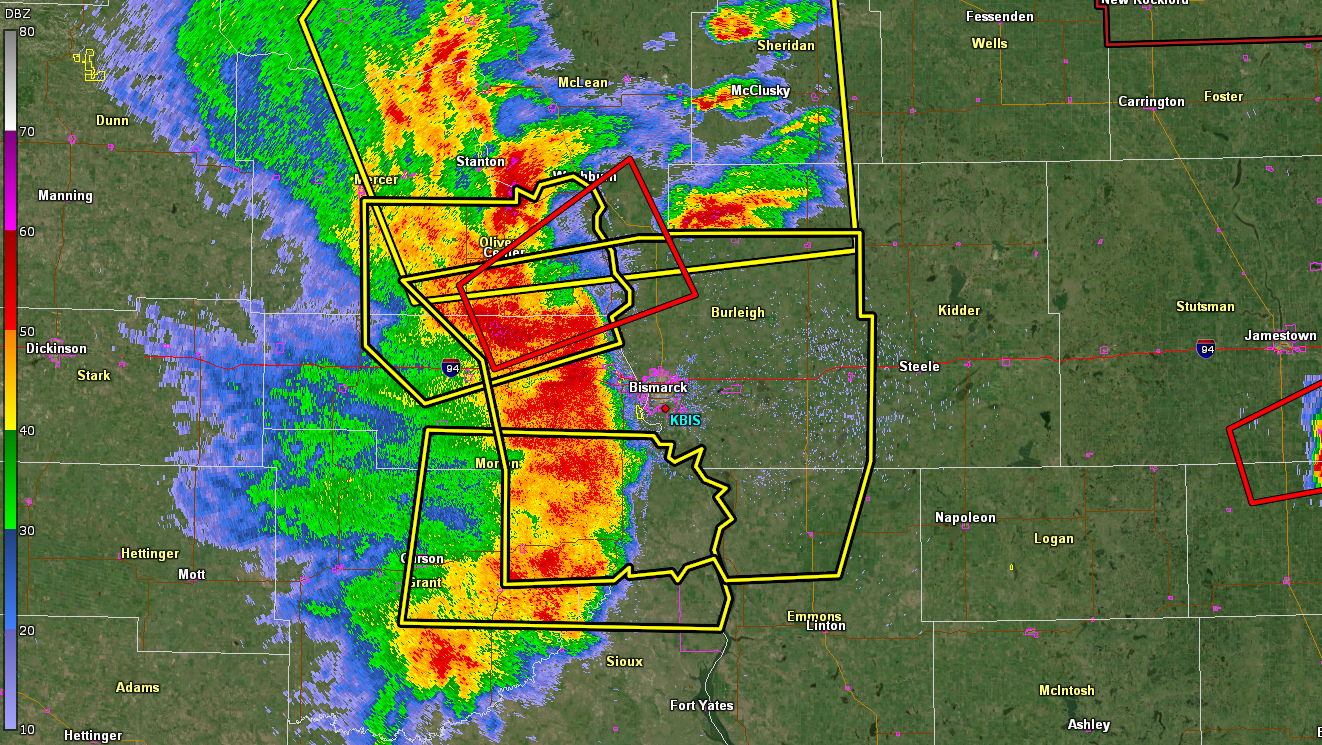 |
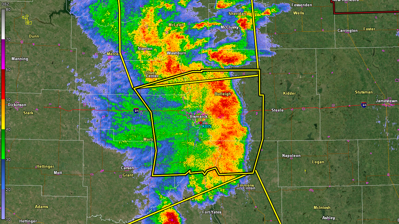 |
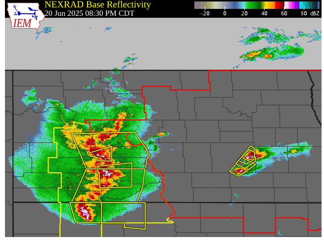 |
| 0.5 Degree Reflectivity from KBIS at 9:05 PM CDT | 0.4 Degree Reflectivity from KBIS at 9:32 PM CDT | Radar Loop of the Derecho Moving Through Central North Dakota |
Environment
Several environmental parameters were in place for a significant outbreak of severe thunderstorms. Most notable was the amount of wind shear, which is the measure of wind changing speed and direction with height, at all levels of the atmosphere. The lowest layer of the atmosphere (up to 1 mile above the surface) also contained strong wind shear, which was one of the key ingredients that resulted in the higher risk for strong tornadoes.
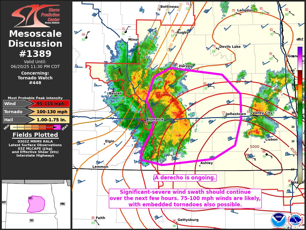
This event has been classified as a derecho, a term that is reserved for the most intense, widespread, and long-lasting lines of severe thunderstorms.
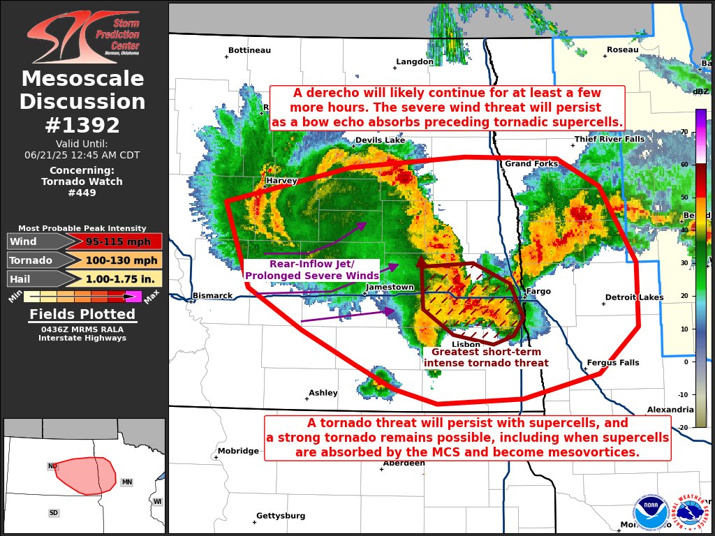
This complex of storms was so intense that it developed its own area of low pressure. This low can be visualized in the radar imagery shown in Figure 5. This feature is known as a "Mesoscale Convective Vortex". While it's not uncommon for a Mesoscale Convective Vortex to form on the northern side of a bowing line of thunderstorms, it is very rare for the small-scale area of low pressure to become so intense in the lower portions of the atmosphere near the ground. In this case, the Mesoscale Convective Vortex was so strong that its associated low pressure system at the surface produced a prolonged period of 80 to 100 mph wind gusts. NWS meteorologists intend to conduct more research into what exactly caused these hurricane force winds behind the line of intense storms.
 |
 |
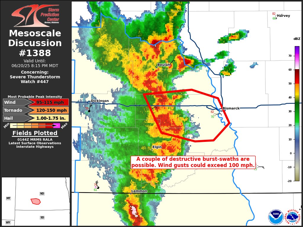 |
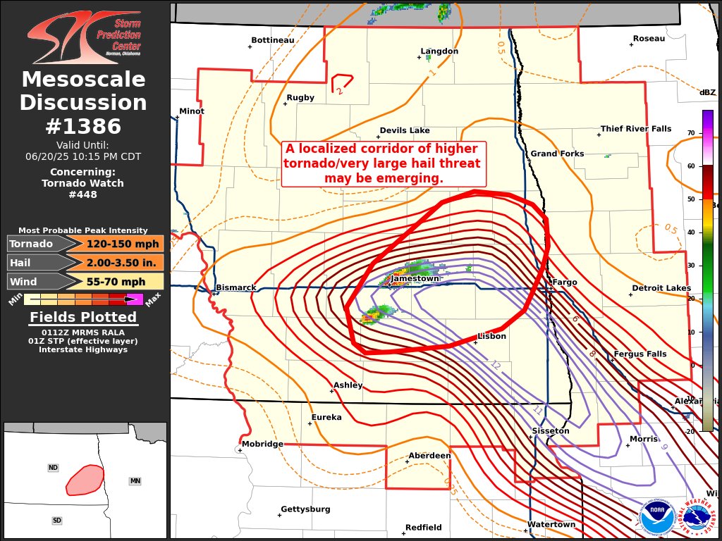
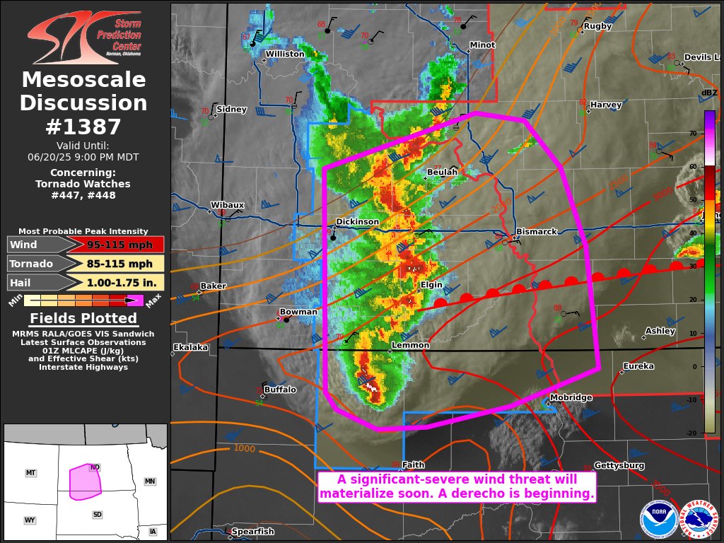
| Figure 1: Storm Prediction Center Mesoscale Discussion #1386 Issued at 8:17 PM CDT | Figure 2: Storm Prediction Center Mesoscale Discussion #1387 Issued at 8:33 PM CDT | Figure 3: Storm Prediction Center Mesoscale Discussion #1388 Issued at 8:47 PM CDT |
 |
 |
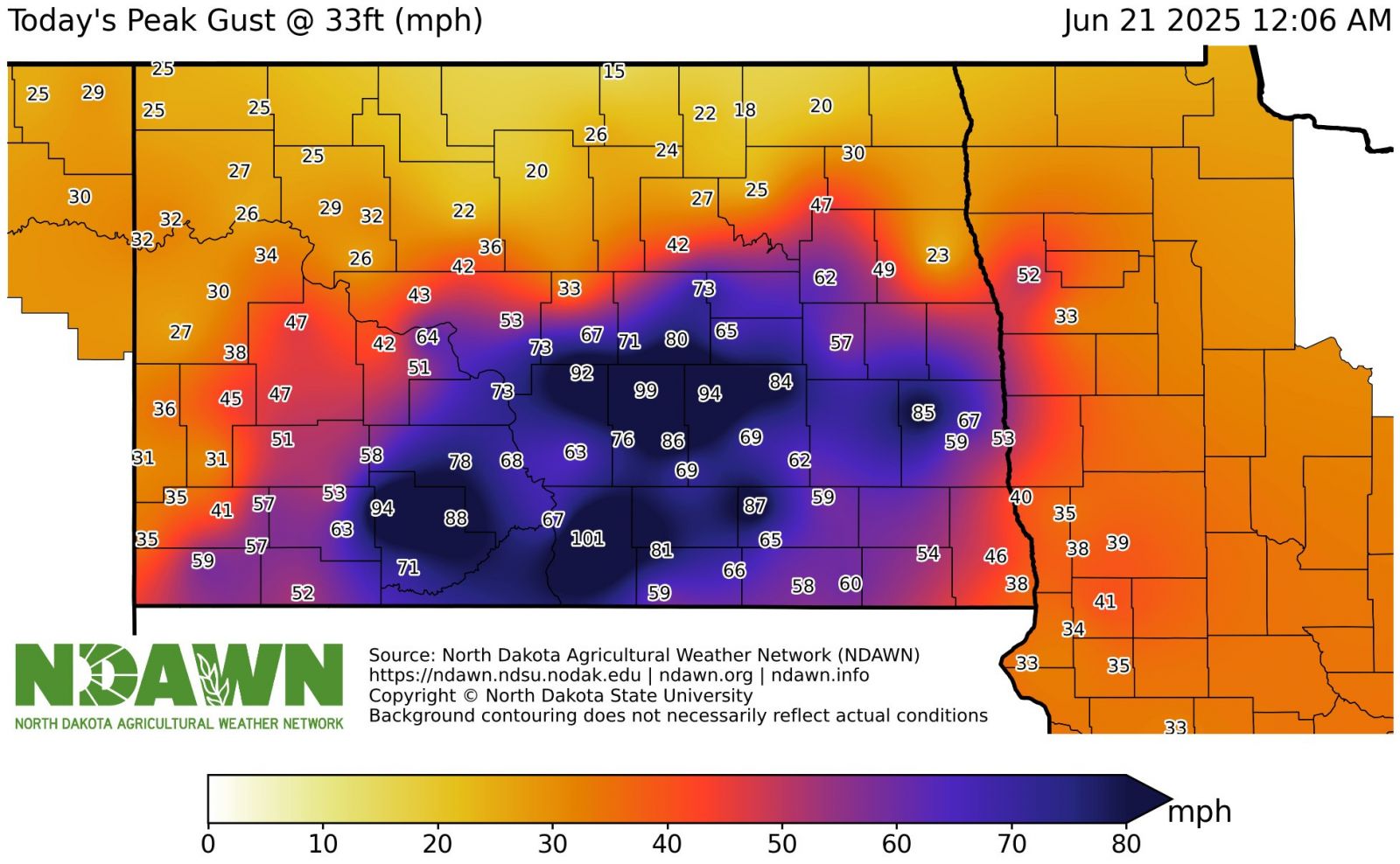 |
| Figure 4: Storm Prediction Center Mesoscale Discussion #1389 Issued at 10:06 PM CDT | Figure 5: Storm Prediction Center Mesoscale Discussion #1392 Issued at 11:41 PM CDT | Figure 6: Peak Wind Gusts on June 20, 2025. Data and Graphic Courtesy of the North Dakota Agricultural Weather Network (NDAWN) |
 |
 |
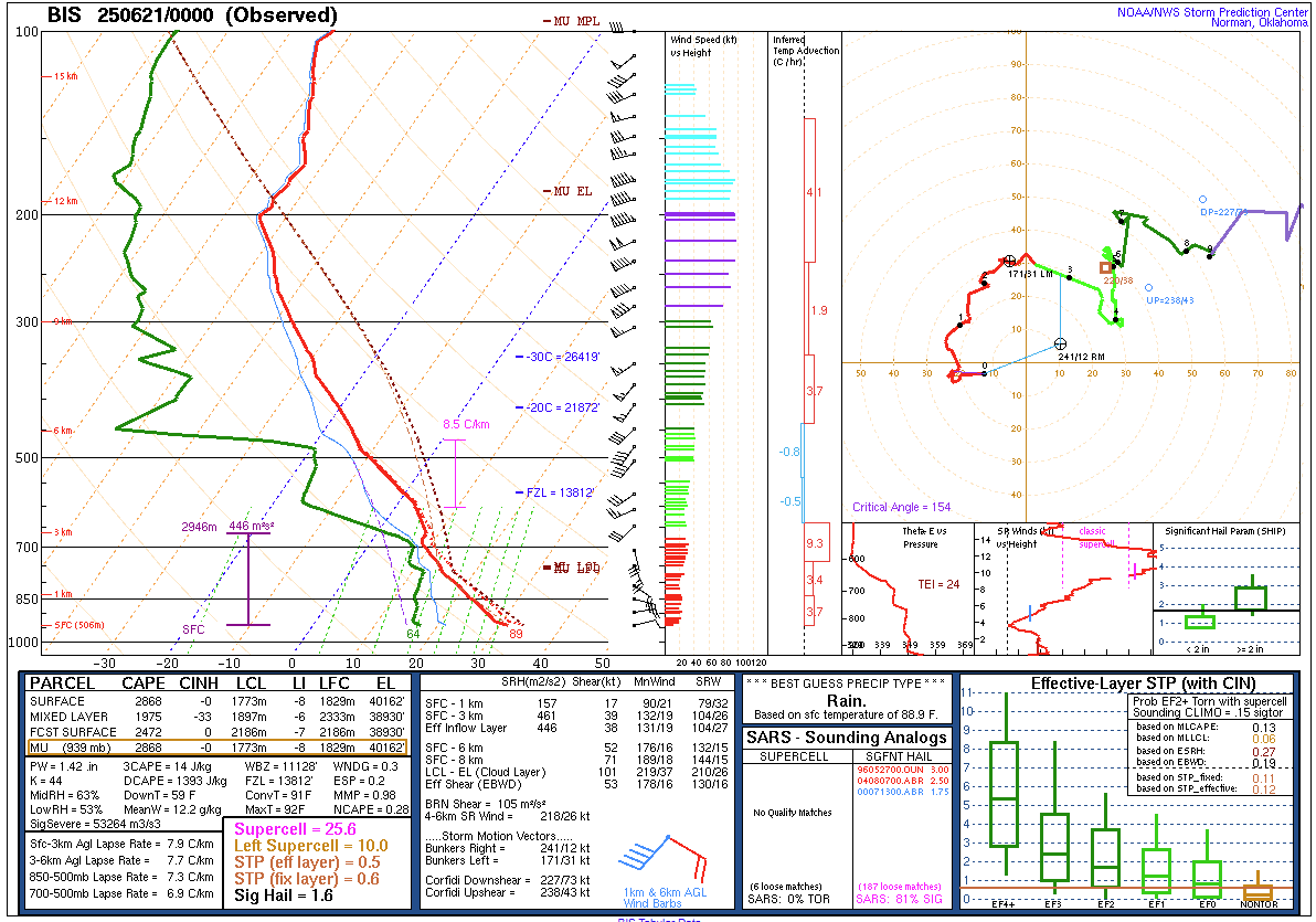 |
| Figure 7: ICECHIP Weather Balloon Sounding at 3:55 PM CDT Near New England, ND | Figure 8: Bismarck Special (4:00 PM CDT) Weather Balloon Sounding | Figure 9: 7:00 PM Bismarck Weather Balloon Sounding |
Tornadoes
Select a tornado from the table to zoom into the track and view more information. The default table view is limited to 8 tracks, but can be scrolled by a mouse wheel or dynamically expanded. Additionally, the table can fill the entire window by clicking the small circular expanding arrow icon at the very top right of the table and returned to its original size by clicking the button again. The side information panel that opens over the map can be closed using the "X" on the upper right corner of the pop-up. Zoom into the map and click damage points to see detailed information and pictures from the surveys.
|
NOTE: times shown below are local to your device's time zone. |

The Enhanced Fujita (EF) Scale classifies tornadoes into the following categories:
| EF0 Weak 65-85 mph |
EF1 Moderate 86-110 mph |
EF2 Significant 111-135 mph |
EF3 Severe 136-165 mph |
EF4 Extreme 166-200 mph |
EF5 Catastrophic 200+ mph |
 |
|||||
| Tornadoes that fail to impact any ratable damage indicators on the EF-Scale are rated EF-Unknown (EF-U) | |||||
 |
Media use of NWS Web News Stories is encouraged! Please acknowledge the NWS as the source of any news information accessed from this site. |
|

