Dangerous heat expands across the Desert Southwest, Plains, Mississippi Valley and Midwest. Critical fire weather for portions of the Intermountain West. Risk for severe thunderstorms and flash flooding across the Upper Midwest/Great Lakes, Ohio Valley, and portions of the mid-Atlantic. Active monsoonal moisture fuels thunderstorms over the Southwest. Hurricane Fausto in the Pacific, should weaken Read More >
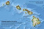
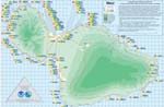
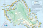
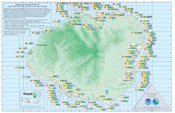
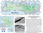
Hawaiʻi > Hawaiʻi Runup Observations
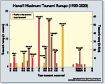
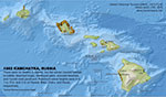
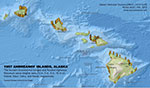
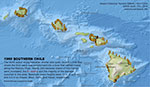
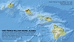
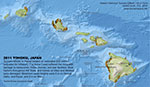
Runups in the Hawaiian Islands for Large, Pacific-Wide, 20th Century Tsunamis was compiled by Professor Daniel A. Walker. Source locations for these tsunamis are the Aleutian Islands (1946 and 1957), the Kamchatka Peninsula (1952), Chile (1960), and Alaska (1964). In 2013, the Japan (2011) event data was added by the International Tsunami Information Center to the islands of Hawaiʻi, Kauai, Maui and Oahu.
Runup data are not available for all of these tsunamis for all of the islands. Runups given are estimated maximum heights in feet of water levels on land relative to sea level, produced by inland flooding of the tsunami’s waves. Runups should not be confused with inundation limits (i.e., horizontal measures of the inland penetrations of a tsunami’s waves). In low-lying areas, inundation can extend inland for several hundred yards. Further discussion of runups, data sources, and the sectional runup maps from which these island-wide maps were derived may be found in:
To download, click on a link.
|
|
|
|
|
|
|
|
|
|
|
|
|
Hawaiʻi Field Guide for Measuring Tsunami Runups and Inundations |
|
|
|
|
|
|
|
|
|
|