| Document Title |
Format/Size |
|
CHILE
- American Society of Civil Engineers. Earthquake Investigations, C. (2013). Chile earthquake of 2010 lifeline performance . Reston, Va: American Society of Civil Engineers. Summary: Chapter 4 “Ports” gives an overview of Chilean port performance following a tsunami from the Chile earthquake of 2010. Keywords: Hazard Assessment .
- Ministry of Public Works Port Works Department. (2020). Featured Information. Summary: Homepage with links to seminar reports and interactive maps of fishing coves and maritime infrastructure. Keywords: Hazard Assessment, Mitigation
- Fishing Coves and Maritime Infrastructure Maps
- Seminars: Directorate of Port Works
- National Register of Procedures
- Work Plate
|
Website
Website
Website
Website
Website
Website
|
|
JAPAN
Fishermen who are inland during a tsunami warning, etc are prohibited from evacuating offshore. This will be applied in all area in Iwate Prefecture. The news also mentioned about one fisherman experience that he ran his boat with a speed of 10 Knots but it was actually just 3 Knots against the tsunami.
- Abe, K., Takano, S.-e., & Kato, H. (2018). Actual Situations and Problems of Fishing Boats Evacuation in Iwate Prefecture at the time of Tohoku Pacific Ocean off Earthquake. Fisheries Engineering , 55, 95-103. Summary: Authors explain issues with offshore evacuation based on questionnaires and interviews with fishermen. Keywords: Hazard Assessment
- Hayashi, M., Nakada, S., Abe, T., & Kobayashi, E.-i. (2016). Influence of Eddies on Vessel Evacuation from Tsunami . Paper presented at the The 26th International Ocean and Polar Engineering Conference, Rhodes, Greece. Summary: Examines properties of eddies in the Port of Sakai Senboku from the Nankai Trough Earthquake. Keyword: Tsunami Modeling
- Imai, K., Inazumi, T., Emoto, K., Horie, T., Suzuki, A., Kudo, K., . . . Sasaki, T. (2019). Tsunami Vulnerability Criteria for Fishery Port Facilities in Japan. Geosciences, 9(10), 410 . doi:10.3390/geosciences9100410 Summary: Develops a method to assess probabilistic tsunami damage at fishery ports such as Nachi Katsu’ura in Wakayama Prefecture. Keywords: Tsunami Modeling
- Katada, T., Murasawa, N., & Kanai, M. (2012). Inspection of the rule development effect about Fishing-Boat Evacuation against Tsunami. Disaster Information . Summary: Table 1 in the top-right of page 2 is a guideline for offshore evacuation for fishing boats. The first column is warning level, second is expected tsunami height, third is suggested sea depth as target for evacuation, and fourth is the required time for evacuation (should not do offshore evacuation if less time than this). Keywords: Tsunami modeling
- Muhari, A., Charvet, I., Tsuyoshi, F., Suppasri, A., & Imamura, F. (2015). Assessment of tsunami hazards in ports and their impact on marine vessels derived from tsunami models and the observed damage data. Natural Hazards, 78 (2), 1309-1328. doi:10.1007/s11069-015-1772-0 Summary: Numerical modeling of the southern part of Honshu Island and a developed loss function for marine vessels. Keywords: Tsunami Modeling
- Suppasri, A., Muhari, A., Futami, T., Imamura, F., & Shuto, N. (2014). Loss Functions for Small Marine Vessels Based on Survey Data and Numerical Simulation of the 2011 Great East Japan Tsunami. Journal of Waterway, Port, Coastal, and Ocean Engineering, 140 (5), 04014018. doi:10.1061/(ASCE)WW.1943-5460.0000244 Summary: The results of study and loss functions may be used for macroscale tsunami hazard and loss predictions with small marine vessels. Keyword: Tsunami Modeling
- Suppasri, A., Nguyen, D., Abe, Y., Yasuda, M., Fukutani, Y., Imamura, F., & Shuto, N. (2015). Offshore evacuation of fishing boats - Lessons from the 2011 Great East Japan tsunami and its future challenge . Summary: Interviews on fishermen’s evacuation response during 2011 Great East Japan Earthquake and its relationship to site geography. Keywords: Response
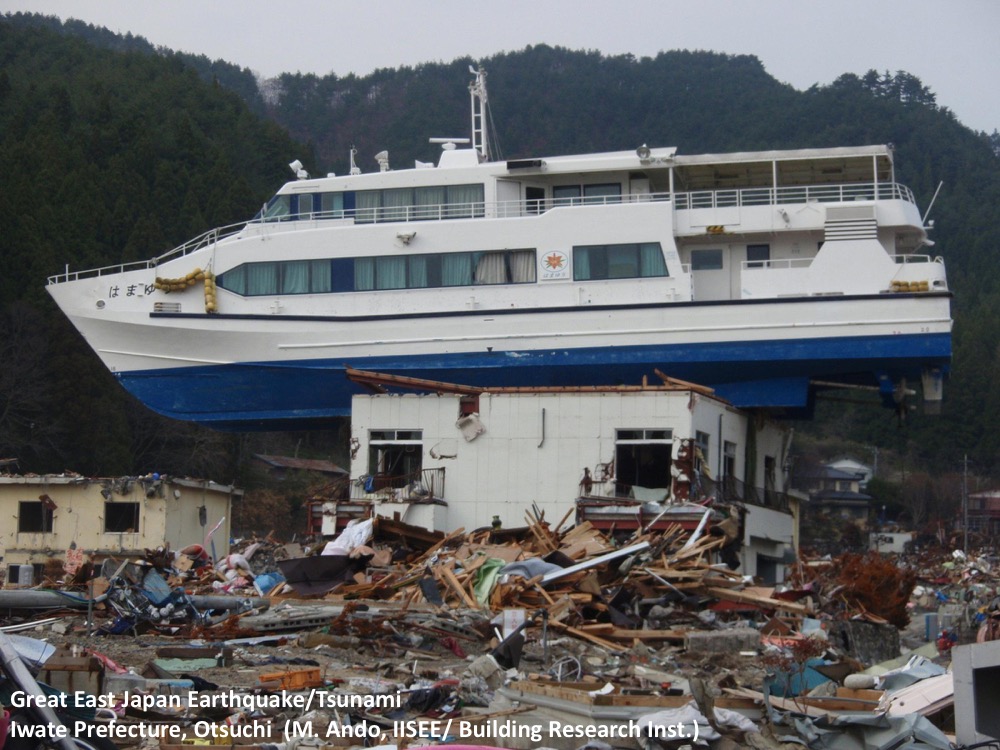
- Technical Council on Lifeline Earthquake Engineering. (2017). Tohoku, Japan, Earthquake and Tsunami of 2011 . Summary: Damage observations in Port of Sendai, Shiogama, Otsuchi, Kamaishi, and Kesenuma. Keywords: Hazard Assessment
- 良典, 鴫., 隆範, 北., 毅, 多., & 宏, 八. (2017). Proposal and application of Tokyo Bay Ship Evacuation Risk Maps during a Tsunami. Paper presented at the JSCE Proceedings B2 (Coastal Engineering) Vol. 73, No. 2, I_415-I_420. Summary: A tsunami risk map for vessel evacuation using numerical simulation in Tokyo Bay, Port of Yokosuka. Keywords: Tsunami Modeling
- Ports and Harbors Bureau. Ministry of Land, Infrastructure, Transport and Tourism. (2013). Guidelines for Tsunami Evacuation Measures at Ports. Summary: How to react to the harbor manager during a tsunami. Keywords: Response.
- Maritime Bureau, Ministry of Land, Infrastructure, Transport and Tourism. (2014). Guidance for Creating a Tsunami Evacuation Manual for Ship Operators. Summary: How to react to the ship captain during a tsunami. Keywords: Response.
- Ministry of Land, Infrastructure, Transport and Tourism. (2005). Ports and Harbors anti-earthquake measures. Summary: Policies to protect Japan’s marine transport network and improves local disaster prevention capabilities, especially during a local tsunami. Keywords: Mitigation.
- Japan Association of Marine Safety, Japan Maritime Center. (2015). Research on Navigation Safety Measures in the Event of Major Earthquake/Tsunami Strikes. Final Report (Excerpt). Summary: Foreign seafarers may refer to this report to learn guidance for tsunami safety measures in a port, and safety/disaster prevention measures for large vessels carrying dangerous cargo. Keywords: Response.
- Maritime Bureau. (2014). Organization and Functions of the Maritime Bureau. English. Summary: Outlines the Maritime Bureau key roles and divisions and defines the Maritime Bureau functions. Keywords: Mitigation.
- Japan Maritime Center. (2015). Japan Maritime Center. English. Summary: Introduces the Japan Maritime Center, organization, mission, and project support program. Keywords: Mitigation.
- Takahashi, S., Kuriyama, Y., Tomita, T., Kawai, Y., Arikawa, T., Tatsumi, D., Port and Airport Research Institute (PARI). Negi, T., National Institute for Land and Infrastructure Management (NLIM). (2011). Urgent Survey for 2011 Great East Japan Earthquake and Tsunami Disaster in Ports and Coasts. An English Abstract of the Technical Note of Port and Airport Research Institute , No. 1231, April 28, 2011.
|
PDF (1.4 MB)
Website
PDF (7.3 MB)
PDF (667 KB)
PDF (2.6 MB)
Website
PDF (1 MB)
Website
Website
PDF (2.11 MB, Japanese)
PDF (7.10 MB, Japanese)
Website
PDF (1.4 MB, English)
PDF (91 KB, English)
PDF (6.1 MB, English)
PDF (739 KB, English) |
|
NEW ZEALAND
- Borrero, J. C., Goring, D. G., Greer, S. D., & Power, W. L. (2015). Far-Field Tsunami Hazard in New Zealand Ports. Pure and Applied Geophysics, 172 (3), 731-756. doi:10.1007/s00024-014-0987-4 Summary: Numerical modeling study for Marsden Point, Tauranga Harbor, Port Taranaki, and Lyttelton Harbor. Keywords: Tsunami Modeling
- Ragued, B., Wotherspoon, L. M., & Ingha, J. M. (2013). A Review of New Zealand Port Infrastructure and Their Vulnerability to Natural Hazards. Summary: Initial study on characteristics of New Zealand port infrastructure and vulnerability to tsunami hazards.
- LEARNZ. (2020). Tsunami Hazard in New Zealand. Summary: Instructions for a locally and distantly generated tsunami for the New Zealand maritime community. Keywords: Response
|
Website
PDF (379 KB)
Website
|
|
USA
Overview (ITIC, June 2020)
US Tsunami Maritime Guidance. A Resource for Tsunami Hazard Planning and Preparedness for Maritime Communities. National Tsunami Hazard Mitigation Program. (2022). Keywords: Mitigation
- US National Tsunami Hazard Mitigation Program, & US Coast Guard. (2017). Guidance for Safe Minimum Offshore Depth for Vessel Movement for Tsunamis. Summary: Table 1 shows minimum offshore safe depths for maritime vessel evacuation prior to arrival of a tsunami for states/territories in a distant source tsunami, local source tsunami, with updated notes. Keywords: Response
- US National Tsunami Hazard Mitigation Program. (2015). Guidelines and Best Practices for Tsunami Hazard Analysis, Planning, and Preparedness for Maritime Communities Version 5 (7-12-15) . Summary: Addresses minimum requirements to develop consistent and reliable tsunami preparedness products for maritime communities. Keywords: Mitigation
- US National Tsunami Hazard Mitigation Program. (2012). Proceedings and Results of the 2011 NTHMP Model Benchmarking Workshop. Boulder: U.S. Department of Commerce/ National Oceanic and Atmospheric Administration / US National Tsunami Hazard Mitigation Program; (NOAA Special Report). 436 p. Summary: Numerical models verified and benchmarked to determine tsunami inundation and run-up. Keywords: Hazard Assessment
- US National Tsunami Hazard Mitigation Program Mapping and Modeling Subcommittee. (2015). Workshop: Tsunami Currents Meeting Notes. Summary: Currents benchmarking workshop addresses adequacy of tsunami models to capture current velocities. Keywords: Hazard Assessment
- US National Tsunami Hazard Mitigation Program. (2015). Development of “MES Guideline for Maritime Tsunami Mapping". Summary: Potential maritime map products and guidelines for developing consistent products across states and territories. Keywords: Hazard Assessment
- US National Tsunami Hazard Mitigation Program. (2016). Update on NTHMP Maritime Preparedness and Response. Meeting. Summary: NTHMP Strategic Plan, new MMS/NTHMP Maritime Guidance document, current benchmark workshop and report, and an update on NOAA states/territories/commonwealths are working on to address maritime issues. Keywords: Hazard Assessment
- Wilson, R., & Miller, K. (2014). Tsunami Emergency Response Playbooks and FASTER Tsunami Height Calculation: Background Information and Guidance for Use . Retrieved from California Department of Conservation California Geological Survey: Summary: Tsunami evacuation playbooks, FASTER tsunami height calculation, and example and guidance for use. Keywords: Hazard Assessment
- Wilson, R., Richards, K., & Miller, K. (2017). 2017 Update on NTHMP Maritime Preparedness, Response, Mitigation, and Recovery Planning. Summary: Updates for maritime planning, NTHMP Strategic Plan measures, and MMS/NTHMP Maritime Guidance/Best Practices document, draft on NTHMP Guidance for USCG for minimum safe offshore depth for vessel movement, current benchmark workshop report, and NTHMP partner states/territories/commonwealths. Keywords: Hazard Assessment, Tsunami Modeling, Mitigation, Response
- US National Tsunami Hazard Mitigation Program. (2018). Tsunami Mitigation Strategies for Harbors. Summary: 2018 updates tsunami mitigation strategies, response planning, and recovery planning for harbors. Keywords: Hazard Assessment
- Lynett, P. J., Borrero, J., Son, S., Wilson, R., & Miller, K. (2014). Assessment of the tsunami-induced current hazard, Geophys. Res. Lett. 41, 2048-2055. doi:10.1002/2013GL058680 Summary: Approach to interpret measured tsunami-induced current impacts and a validation approach for simulation tools. Keywords: Hazard Assessment
- National Oceanic and Atmospheric Administration / National Centers for Environmental Information. (2020). Summary: Historical tsunami database on past tsunamis that show if, where, and how much damage occurred in a specific maritime community. Includes documents, personal accounts, videos. Keywords: Hazard Assessment
- National Oceanic and Atmospheric Administration / National Weather Service. (2020). Tsunami Warning System Exercise. Summary: Website with links to exercise manuals and resources for planning. Keywords: Response
- Southern California Earthquake Center. (2020). TsunamiZone. Summary: Website with links to “Tsunami Walk How-To Guide” and “Register your Tsunami Preparedness Activities.” TsunamiZone.org has links to know your zone and register tsunami preparedness activities. Keywords: Response
- Tsunami Maritime Guidance. (2021). Summary: Website developed as a resource for tsunami hazard planning and preparedness for Maritime Communities. Keywords: Mitigation, Response
- TsunamiZone. (2019). Maritime Tsunami Preparedness. YouTube video. Summary: YouTube video on how to prepare for a tsunami if at port or operating a vessel. Keywords: Response
|
PDF (2020, 1.1 MB)
Website
PDF (485 KB)
PDF (4.4 MB)
PDF (15.3 MB)
PDF (292 KB)
PDF (1.4 MB)
PDF (5.1 MB)
PDF (8.1 MB)
PDF (4.3 MB)
PDF (1.3 MB)
PDF (4.2 MB)
Website
Website
Website
Website
YouTube
|
|
USA - CALIFORNIA
- California Department of Conservation. (2020). Tsunamis . Summary: Links for tsunami maritime preparedness documents in California. Keywords: Mitigation, Response
- Tsunamis! What Boaters should know
- Maritime Tsunami Response Playbooks: Background Information and Guidance for Response and Hazard Mitigation Use (CGS Special Report 241, 2016)
- Example Draft Tsunami Response Playbook and Mitigation Guidance for Ventura Harbor – Ventura County
- Tsunami Hazard Mitigation Activities in California Maritime Communities
- California Geological Survey, California Governor's Office of Emergency Services, US National Tsunami Hazard and Mitigation Program, National Oceanic and Atmospheric Administration (2020). Can my boat outrun a tsunami? Summary: Poster explaining if your boat can outrun a tsunami. An example map of maximum water currents in port of Los Angeles and Long Beach is provided. Keywords: Response
- California Geological Survey, California Governor's Office of Emergency Services, US National Tsunami Hazard and Mitigation Program, & National Oceanic and Atmospheric Administration. (2020). Can I surf a Tsunami? Summary: Poster explaining why you cannot surf a tsunami. Keywords: Mitigation
- National Weather Service Eureka. (2013). Fisherman Describes Attempt To Outrun Tsunami - Crescent City, CA. YouTube video. Summary: A fisherman shares experience escaping Crescent City harbor after 2011 tsunami. Keywords: Response
- California State Hazard Mitigation Plan Chapter 7 - Flood Hazards: Risks and Mitigation . (2018). Summary: Additional tsunami hazard mitigation material from City of Watsonville. Keywords: Response
- California Tsunami Policy Working Group. (2014). California’s Tsunami Risk A Call for Action . Summary: Provides recommendations to prepare maritime community for tsunami hazards. Keywords: Mitigation
- One San Francisco. (2019). City and County of San Francisco Hazards and Climate Resilience Plan . Summary: Shoreline mitigation strategies to protect maritime assets in the Port of San Francisco from a tsunami. Keywords: Mitigation
- California Governor’s Office of Emergency Services. (2020). Debris Management. Summary: Debris Management Guidance for California. Keywords: Mitigation
- California Geological Survey, University of Southern California, California State Lands Commission, & California Governor’s Office of Emergency Services. (2017). Harbor Improvement Report No. 2017-SD-01 Oceanside and Camp Pendleton Harbors – San Diego County . Summary: Maritime Tsunami and Coastal Mitigation Guidance for Harbor Engineers and Emergency Managers. Keywords: Mitigation
- California Geological Survey, University of Southern California, California State Lands Commission, California Governor’s Office of Emergency Services. (2017). Harbor Improvement Report No. 2017-DN-01 Crescent City Harbor - Del Norte County . Summary: Maritime Tsunami and Coastal Mitigation Guidance for Harbor Engineers and Emergency Managers. Keywords: Mitigation
- Wilson, R. I., Admire, A. R., Borrero, J. C., Dengler, L. A., Legg, M. R., Lynett, P., McCrink, P., et. al. (2012). Observations and Impacts from the 2010 Chilean and 2011 Japanese Tsunamis in California (USA). Pure and Applied Geophysics . doi:10.1007/s00024-012-0527-z Summary: Contains a map of California with locations of interest from the 2010 and 2011 tsunamis, tables of forecasted and observed tsunami arrival times and amplitudes, with summaries of damage, tsunami flow maps and still images of Crescent City Harbor and Santa Cruz Harbor, and a NOAA marigram. Keywords: Hazard Assessment, Tsunami Modeling
|
Website
PDF (1.7 MB)
PDF (4 MB)
PDF (2.2 MB)
PDF (519 KB)
PDF (1.7 MB)
PNG (1.5 MB)
YouTube
PDF (10 MB)
PDF (5.5 MB)
PDF (11 MB)
Website
PDF (4 MB)
PDF (3 MB)
Website |
|
USA - HAWAII
- Department of Land and Natural Resources / Division of Boating and Ocean Recreation. (2013). Tsunami Emergency Plan. Summary: Maritime preparedness planning for Hawaii boaters. Keywords: Response, Mitigation
- TetraTech. (2018). Draft State of Hawaii Hazard Mitigation Plan . Summary: Overview of 2018 HMP update, planning process, state profile, risk assessment, capability assessment, mitigation strategy, and maintenance plan. Keywords: Mitigation
- Hawai‘i State Civil Defense. (2013). Hawai‘i Boater’s Hurricane and Tsunami Safety Manual. Summary: Tsunami emergency plan for boat owners. Keywords: Response
|
PDF (635 KB)
PDF (20.3 MB)
PDF (971 KB)
|
|
USA - HAWAII, GUAM, AMERICAN SAMOA
- Cheung, K. F. (2018). Tsunami Modeling for Apra Harbor, Guam . Summary: Maritime hazard mapping in Hawaii and American Samoa, modeling strategy for Guam, model setup validation, sample data products for Apra Harbor, and input from the maritime community. Keywords: Hazard Assessment, Tsunami Modeling
- Cheung, K. F., Yamazaki, Y., Bai, Y., & Li, L. (2018). Modeling and Mapping of Tsunami Hazards for Maritime Communities in US Pacific Islands . Paper presented at the UNESCO IOC Symposium: Advances in Tsunami Warning to Enhance Community Responses, Paris, France, 12-14 February 2018. Summary: Maritime hazard maps for American Samoa, Guam, and Hawaii with data products for US Coast Guard District 14. Keywords: Tsunami Modeling
|
PDF (6.2 MB)
PDF (2 MB)
|
|
USA - OREGON
Oregon is that it takes less than 20 minutes for the tsunami on our subduction zone to reach the coast, making it virtually impossible for those in the ports and harbors to evacuate offshore in time. Hence, our evacuation approach will ignore those already in port (evacuate to high ground only) and has focused on those already out on the ocean. For them, the recommendation is to proceed westward to deep water (~100 fathoms).
- Oregon Department of Geology and Mineral Industries. (2020). Tsunami Awareness for Boaters, Fishermen & Mariners. Summary: Homepage for updated links to Oregon maritime guidance. Keywords: Response
- Oregon Department of Geology and Mineral Industries. (2020). Tsunami! What Oregon Boat Owners Need to Know. Summary: Vessel Owners and Boating Community. What Oregon Boat Owners Need to Know. Keywords: Response
|
Website
PDF (1.7 MB) |
|
USA - PUERTO RICO
- Puerto Rico Seismic Network. (2019). Tsunami Preparedness Guide Maritime and Port Community of Puerto Rico. Spanish. Summary: Guide and recommendations to prepare tsunami response plans for the maritime community and port operators in Puerto Rico. Keywords: Response
- NSF/PRSN/NOAA-NWS. (2010). Tsunami Guideline Plan for Operators of Caribbean Ports . Paper presented at the Tsunami Ports Operators Workshop (November 2-3, 2010), Mayagüez, Puerto Rico. Summary: Hazards in port facilities and tsunami history in the Caribbean. Keywords: Mitigation
|
PDF (3.9 MB)
PDF (6.3 MB)
|
|
USA - WASHINGTON
- Washington Military Department Emergency Management Division Washington State Department of Natural Resources United States Geological Survey National Tsunami Hazard Mitigation Program. (2013). Understanding Tsunami Hazards in the State of Washington - How Vulnerable is the City of Port Angeles to Tsunamis? Summary: Tsunami hazard, Port Angeles’ vulnerability, most vulnerable people, and economic impacts. Keywords: Hazard Assessment
|
PDF (961 KB)
|