|
JAPAN
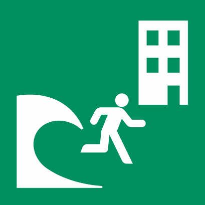
Mayors should select public or private facilities in evacuation areas as tsunami evacuation buildings for evacuees of difficult-to-evacuate areas or people failing to evacuate smoothly.
|
The safety of a tsunami evacuation buildings
|
The structure must be RC or SRC (reinforced concrete or steel reinforced concrete). Generally, the buildings must be 2 stories or higher than the expected inundation depths.
They must not face to the ocean.
They must be earthquake-resistant
It is desirable for the building to front to evacuation routes.
It is desirable for the building to have stairs on the outside.
|
|
The functionality of a tsunami evacuation building
|
Generally, enough space must be available for each evacuee (at least, 1 m2 per evacuee).
It is desirable for it to be furnished with lights and communication equipment.
|
Residential apartments, hotels, factories, warehouses and so on can be tsunami evacuation buildings. IT is essential for the owners or managers of designated buildings to fully understand fully what is needed. Their cooperation is necessary for formulating the regional plan. Designating as many tsunami evacuation buildings as possible are is desirable.
- If there is no high building in the tsunami inundation areas, construction of artificial high ground or a tsunami evacuation tower should be considered.
- When evacuating, each evacuee should be flexible. For example, sometimes it is safer to evacuate to upper level of building than to outside of the building.
- If there are only residences on high ground or there are private lands that can be appropriate emergency evacuation points, it will be necessary to get the agreement of the owner and evacuation stairs may need to be constructed.
- It is recommended to identify areas where residents should evacuate to tsunami evacuation buildings, especially if the evacuation distance and the capacity of the tsunami evacuation routes make it more difficult than to evacuate to an evacuation building.
EXAMPLES
Vertical Evacuation Buildings
Vertical Evacuation Refuges
Vertical Evacuation Platforms
- Robertson, I. N. (2020). Efficacy of Vertical Evacuation Refuge from Tsunamis (VERT), EGU General Assembly 2020, Online, 4–8 May 2020, EGU2020-4349, https://doi.org/10.5194/egusphere-egu2020-4349 Summary: This presentation discusses the effect of tsunami design, cost, and recent VERT design and construction projects. Keywords: Engineering Assessment, Building Code
- Japan, City of Sendai Crisis Management Department Disaster-resilient City Promotion Section. (March 2015). Development of tsunami evacuation facilities in Sendai city. Sendai, Japan. Summary: Vertical evacuation facilities in Sendai. Keywords: Building Code
- Japan, City of Sendai Crisis Management Department Disaster-resilient City Promotion Section. (2015). Development of tsunami evacuation facilities in Sendai city. In. Sendai, Japan. Summary: Vertical Evacuation facilities in Sendai (Page 6). Keywords: Building Code
- Fraser, S., Leonard, G. S., Murakami, H., Matsuo, & Ichiro. (2012). Tsunami Vertical Evacuation Buildings – Lessons for International Preparedness Following the 2011 Great East Japan Tsunami. Journal of Disaster Research , 446-457. doi:10.20965/jdr.2012.p0446. Summary: This paper discusses observations of buildings in connection with themes that arose during semi-structured interviews with local disaster prevention and emergency services officials. Keywords: Building Code
|
PDF (354 KB)
PDF (577 KB)
PDF
PDF (2.6 MB, English)
PDF (2.6 MB, Spanish)
Website
Website
PPT (1.8 MB)
PDF (8.3 MB)
Website
|
|
USA
- ASCE. (2020). ASCE 7-16 Tsunami Design Zone Maps for Selected Locations. Retrieved from https://ascelibrary.org/doi/book/10.1061/9780784480748
- ASCE. (2017). Probabilistic Tsunami Design Maps for the ASCE 7-16 Standard. In ASCE 7-16 Tsunami Design Zone Maps for Selected Locations (pp. 1-17).
- US FEMA. (2019). Guidelines for Design of Structures for Vertical Evacuation from Tsunamis . FEMA P646, 3rd ed., USA. (original 2008). A revised guide for community resource planning, and background, guidance, and commentary on technical design provisions in ASCE/SEI 7-16. Keywords: Mitigation, Building Code
- Wood, N., Jones, J., & Peters, J. (2017). Pedestrian Evacuation Analyst Tool. Retrieved from https://www.usgs.gov/software/pedestrian-evacuation-analyst-tool Summary: Evacuation Analyst (which includes ability to model proposed VE sites). Keywords: Engineering Assessment
- Yeh, H., Robertson, I., & Preuss, J. (2005). Development of Design Guidelines for Structures that Serve as Tsunami Vertical Evacuation Sites . USA Summary: An exploratory study on building safely against seismic-tsunami loads. Keywords: Building Code
- National Weather Service. (2018). National Tsunami Hazard Mitigation Program Strategic Plan 2018 - 2023 . Department of Commerce: 8-10. Retrieved from https://nws.weather.gov/nthmp/documents/
NTHMPStrategicPlan.pdf. Summary: The National Tsunami Hazard Mitigation Program 2018-2023 Strategy 2.2.2 aims to help high-risk communities develop vertical evacuation plans. Keywords: Mitigation
USA - AMERICAN SAMOA
- Wood, N., Jones, J., Yamazaki, Y., Cheung, K.-F., Brown, J., Jones, J., & Abdollahian, N. (2019). Population vulnerability to tsunami hazards informed by previous and projected disasters: a case study of American Samoa. Natural Hazards, 95 (3), 505-528. doi:10.1007/s11069-018-3493-7. Summary: Vertical evacuation structures may be considered in areas of lengthy pedestrian travel time. Figure 13 shows estimated pedestrian travel times for American Samoa villages of Leone, Nu’uuli, and Aunu’u. Keywords: Engineering Assessment
USA - CALIFORNIA
- Miller, K., LaDuke, Y., Wilson, R., & Pridmore, C. (2019). Application of Probabilistic Tsunami Products. 2019 National Tsunami Hazard Mitigation Program Winter Meetings, Topical Workshops . Retrieved from https://nws.weather.gov/nthmp/2019annualmeeting/
ApplicationProbablistic.pdf. Summary: CalOES identifies inundation maps, evacuation planning, and assists communities with vertical evacuation structure plans. Keywords: Engineering Assessment
USA - GUAM
- Hawaii Emergency Management Agency. (2015). Retrieved from https://dod.hawaii.gov/hiema/public-resources/tsunami-evacuation-zone/ Summary: Guam tsunami evacuation map. Keyword: Response
USA - HAWAII
Hawaii has had a policy of vertical evacuation for Waikiki, Oahu, since the 1990s. On any day, it is estimated that on any day there are more than 50,000 tourists (many non-English speakers), workers, school children, shoppers, beachgoers, and residents crammed into a three square mile area that has just 4 evacuation routes inland. The situation presents a nightmare for safe evacuation within a 3-hour tsunami warning window before the nearest tsunami hits from the Aleutian Islands. As result, the City & County of Honolulu implemented a vertical evacuation policy for Waikiki, and this has been extended for the island of Oahu and other islands. The policy permits evacuation to the fourth floor or higher in structural steel or reinforced concrete or buildings 10 stories or higher.
- ASCE. (2017). Oahu: Waikiki to Honolulu International Airport. Retrieved from https://ascelibrary.org/doi/10.1061/9780784480748.047 Summary: ASCE PDF of ASCE 7-16 Tsunami Design Zone for Waikiki to Honolulu International Airport on Oahu Island, Hawaii. Keyword: Mitigation
- Carden, Lyle & Yu, Guangren & Chock, G. & Robertson, Ian. (2016). Tsunami-Resilient Building Designs for Hawaii and Other High Hazard Regions. Summary: Research article encourages Risk Category II buildings to be designed for tsunami loads. Keyword: Mitigation
- Department of Emergency Management. (2020). Tsunami. Retrieved from http://www.honolulu.gov/site-dem-sitearticles/35781-tsunami.html Summary: Homepage with links to descriptions and maps of tsunami evacuation routes and arrival times. Keyword: Response
- Oahu Tsunami Evacuation Map
- Tsunami Facts Frequently asked questions
- Safe Room Planning
- Hwang, D. O., Darren K. (2019). Homeowner’s handbook to prepare for natural hazards . Retrieved from University of Hawai’i Sea Grant College Program Fourth Edition, Version 4.0: 46-53. https://seagrant.soest.hawaii.edu/homeowners-handbook-to-prepare-for-natural-hazards/. Summary: This handbook helps homeowners prepare for a natural hazard to reduce risks to property and family. Keywords: Response
- State of Hawaii Department of Accounting and General Services State Buliding Code Council. (2018). State Building Code Adoption. Summary: Per November 13, 2018 report, all Hawaii counties adopt reference section 1615 Tsunami loads and effects.
- Wood, N., Jones, J., Peters, J., & Richards, K. (2018). Pedestrian evacuation modeling to reduce vehicle use for distant tsunami evacuations in Hawaiʻi. International Journal of Disaster Risk Reduction, 28 , 271-283. doi:10.1016/j.ijdrr.2018.03.009 Summary: Oahu Tsunami Evacuation Map references
USA - OREGON
- Gabel, L., et al. (2020). Beat the Wave Maps. Retrieved from https://www.oregongeology.org/tsuclearinghouse/
beatthewave.htm. Summary: Beat the wave tsunami evacuation map modeling that include evaluation of potential vertical evacuation structure locations for various Oregon communities. Warrenton and Clatsop Spit, Clatsop County, Oregon, O-16-08. Rockaway Beach, Tillamook County, Oregon, O-17-06. Port Orford, Curry County, Oregon, O-20-05. Newport, Lincoln County, Oregon, O-19-05. Lincoln City and unincorporated Lincoln County, Oregon, O-19-06. Keywords: Response
- Hatfield Marine Science Center. (2020). Retrieved from https://hmsc.oregonstate.edu/marine-studies-building#Engineering%20Model. Summary: Example tsunami vertical evacuation building with video on foundation construction. Keywords: Building Code
- Wang, Y. (2010). Tsunami Evacuation Building Workshop, September 28-29, 2009, Cannon Beach, Seaside, and Portland, Oregon. DOGAMI Open-File Report O-10-02. Summary: The Cascadia Region Earthquake Workgroup (CREW) held the first regional workshop that addressed tsunami vertical evacuation as a new means to protect people and improve community recovery. Keywords: Response
USA - WASHINGTON
Washington Emergency Management Division. (2018). Manual for Tsunami Vertical Evacuation Structures. Retrieved from Camp Murray, WA: https://mil.wa.gov/asset/5cffea88adefb. Summary: Documentation and media to support vertical evacuation structures in Washington. Keywords: Mitigation, Response, Building Code
- Manual for Tsunami Vertical Evacuation Structures, 2018.
- Executive Summary
- Checklist. 7 steps
- Ocosta Elementary School, 1st US Vertical Evacuation Structure, 2016
- Poster, T. Walsh, J. Schelling C. Ash, R. LaVeque, L. Adams, and F. Gonzales, Geological Soc. Amer, 2014
- ‘It will happen here’: Washington Coast school builds nation’s first tsunami refuge, Seattle Times, June 9, 2016
- Stronger than Waves, video, NOAA
- Wood, N., Jones, J., Schelling, J., & Schmidtlein, M. (2014). Tsunami vertical-evacuation planning in the U.S. Pacific Northwest as a geospatial, multi-criteria decision problem. International Journal of Disaster Risk Reduction, 9 , 68-83. doi:10.1016/j.ijdrr.2014.04.009. Summary: A case study of tsunami-vertical evacuation sitting in Ocean Shores, Washington. Keywords: Engineering Assessment
- Adams, L. M., González, F. I., & LeVeque, R. J. (2020). UW Tsunami Modeling Group Modeling Projects and Reports. Retrieved from http://depts.washington.edu/ptha/projects/index.html. Summary: A link to continually updated University of Washington’s tsunami modeling group website. See documents “Modeling for Aberdeen School District (2020)”, “Modeling for Shoalwater Bay Tribe (2020)”, and “Issues Encountered with ASCE Compatibility Criteria (2019)”. Keywords: Engineering Assessment
- Farley, G. (2020). Washington lab gets NASA grant for earthquake and tsunami warnings. Retrieved from https://www.king5.com/article/weather/earthquakes/pnw-organization-gets-grant-from-nasa-to-create-early-tsunami-warnings/281-1ba418db-775a-4bfc-b166-56f1b0500ae5 Summary: Report on new NASA grant. Keyword: Mitigation
- Yeh, Harry, Robertson, Ian, & Preuss, Jane (2005) Development of design guidelines for structures that serve as tsunami vertical evacaution sites. Washington Division of Geology and Earth Resources Open File Report 2005-4, 34 p. http://www.dnr.wa.gov/Publications/ger_ofr2005-4_tsunami_evac_site_design_guidelines.zip
- Jones, J.M., Ng, P., Wood, N.J., 2014, The pedestrian evacuation analyst—Geographic information systems software for modeling hazard evacuation potential: U.S. Geological Survey Techniques and Methods, book 11, chap. C9, 25 p., http://dx.doi.org/10.3133/tm11C9.
- Mostafizi, Alireza, Wang, Haizhong, Cox, Dan, & Dong, Shangjia (2019) An agent-based vertical evacuation model for a near-field tsunami: Choice behavior, logical shelter locations, and life safety. International Journal of Disaster Risk Reduction, v. 34, p. 467-479, https://doi.org/10.1016/j.ijdrr.2018.12.018.
- Park, Sangki, van de Lindt, J. W., Gupta, Rakesh, & Cox, Daniel (2012) Method to determine the locations of tsunami vertical evacuation shelters. Natural Hazards, v. 63, p. 891-908, DOI 10.1007/s11069-012-0196-3.
- Chock, G. Y. K., Carden, Lyle, Robertson, Ian, Wei, Yong, Wilson, Rick, & Hooper, John (2018) Tsunami-Resilient Building Design Considerations for Coastal Communities of Washington, Oregon, and California. Journal of Structural Engineering, 144(8), https://doi.org/10.1061/(ASCE)ST.1943-541X.0002068.
- Wang, Haizong, Mostafizi, Alireza, Cramer, L. A., Cox, Dan, Park, hyoungsu (2016) An agent-based model of a multimodal near-field tsunami evacuation: Decision-making and life safety. Transportation Research Part C: Emerging Technologies, v. 64, p. 86-100, https://doi.org/10.1016/j.trc.2015.11.010.
- Cawley, Jessica Grace (2014) Review of Guidelines for the Design of Tsunami Vertical Evacuation Buildings. Oregon State University Master of Science thesis, 81 p., https://ir.library.oregonstate.edu/concern/graduate_thesis_
or_dissertations/dn39x412j.
- Chock, Gary, Yu, Guangren, Thio, Hong Kie, & Lynett, P. J. (2016) Target Structural Reliability Analysis for Tsunami Hydrodynamic Loads of the ASCE 7 Standard. Journal of Structural Engineering, 142(11), https://doi.org/10.1061/(ASCE)ST.1943-541X.0001499.
- Adams, L. M., Gonzalez, F. I., & LeVeque, R. J. (2020) Preliminary Modeling Study of a Vertical Evacuation Structure Site for the Aberdeen School District. University of Washington Department of Earth and Space Sciences Faculty Report, 32 p., https://digital.lib.washington.edu/researchworks/handle/
1773/45387.
- Adams, L. M., Gonzalez, F. I., & LeVeque, R. J. (2020) Modeling Study of a Proposed Vertical Evacuation Structure Site for the Shoalwater Bay Tribe Final Project Report. University of Washington Department of Earth and Space Sciences Faculty Report, 36 p., https://digital.lib.washington.edu/researchworks/handle/
1773/45287.
|
Website
PDF (1.7 MB)
PDF (23 MB)
Website
PDF (5.9 MB)
PDF (2.3 MB)
PDF (1.7 MB)
Website
Website
PDF (20 MB)
Website
Website
Website
PDF (2.6MB)
PDF (1.6MB)
PDF (6.5 MB)
PDF (23 MB)
PDF (2 MB)
Website
Website
PDF (15 B)
PDF (1.7MB)
PDF (89KB)
PDF (6.0MB)
PDF (689KB)
YouTube
PDF (3.5 MB)
Website
Website
ZIP
Website
Website
Website
Website
Website
Website
Website
Website
Website
|

 refuge is a structure or earthen mound designated as a place of refuge in the event of a tsunami. The refuge is designed for short-term protection (12-24 hours), has sufficient height to elevate evacuees above the tsunami inundation level, and has been designed and constructed to withstand an earthquake and resist tsunami load effects. An evacuation shelter is designed for longer-term use; it provides a safe, sanitary, and secure environment and life-sustaining services to disaster survivors displaced from their primary residences due to natural or man-made disasters.
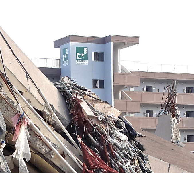 Structure
