Tropical cyclones such as hurricanes and tropical storms pose the greatest weather threat to the Florida Keys and its coastal waters. Due to the small land areas and only 1 major highway in and out of the Keys, the Keys are extremely vulnerable to tropical systems. It is estimated that it takes approximately 2 days to fully evacuate the Keys. This is why evacuation orders from local emergency officials begin well in advance before a hurricane is expected to affect the Keys. The NWS recommends that you heed any evacuation orders associated with hurricanes or tropical storms that are issued by local emergency officials.
TROPICAL CYCLONE CLASSIFICATIONS
Tropical cyclones are classified into 3 categories, tropical depressions, tropical storms and hurricanes. A tropical depression is an organized system of showers and thunderstorms that has a circulation center with maximum sustained winds of 38 mph (33 knots) or less. A tropical storm is a better organized system of showers and thunderstorms with a well defined circulation center with maximum sustained winds of 39 to 73 mph (34-63 knots). A hurricane is a well defined system of showers and thunderstorms with a well defined circulation center with maximum winds of 74 mph (64 knots) or greater.
Hurricanes are categorized by the Saffir-Simpson Scale. The categories range from 1 to 5 with 1 being the weakest and 5 being the strongest. The scale takes certain measured parameters of a hurricane and relates those to how much damage a storm can cause. The Saffir-Simpson scale is listed below.
Category Central pressure Winds Storm surge Damage
Millibars Inches Mph Feet
1 >979 > 28.91 74-95 4-5 Minimal
2 965-979 28.50-28.91 96-110 6-8 Moderate
3 945-964 27.91-28.47 111-130 9-12 Extensive
4 920-944 27.17-27.88 131-155 13-18 Extreme
5 <920 <27.17 > 155 >18 Catastrophic
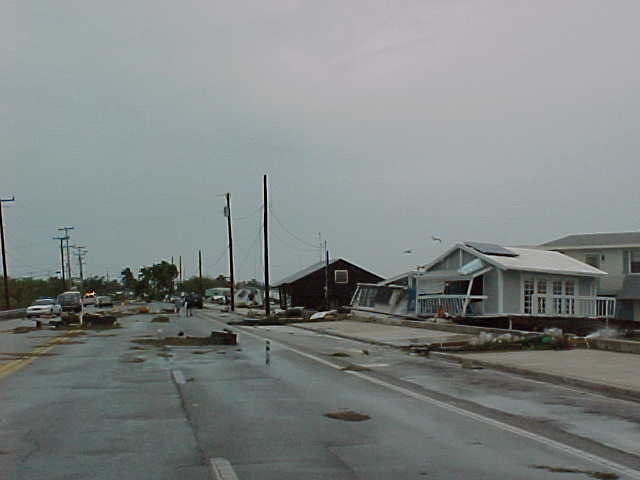
Hurricane Georges struck the Florida Keys in Sept. 1998. The lowest pressure and highest sustained winds measured made Georges a category 1 storm. Damage in the lower Keys from Key West to mile marker 15, as indicated above along houseboat row in Key West, reflected that of a category 1 storm. Damage from Mile Marker 15 to Bahia Honda Key was more indicative of a category 2 storm, so, wind speeds were likely highest in that area.
Damage from a hurricane begins to increase dramatically when it reaches the category 3 stage.
The wind damage caused by a 115 mph storm is much greater than from a 105 mph storm whereas the difference in wind damage between a 95 mph and 105 mph storm is not as great.
There have been only 2 category fives to hit the U.S. One was Hurricane Camille which hit the MS/LA coast in August 1969 and the Labor Day Storm which made landfall near upper Matecumbe Key in the Upper Florida Keys in September 1935.
Near the center of each of these cyclones is generally the strongest winds and heaviest rainfall and the eastern halves of tropical cyclones are usually stronger than the western halves. However, severe and dangerous weather such as tornadoes and coastal flooding can occur well ahead of the center of tropical cyclones and on the western half as well. The entire storm should be treated as dangerous.
FORMATION AND FREQUENCY
The Atlantic Hurricane Season (including the Caribbean Sea) runs from June 1 to November 30 each year. This does not mean that tropical cyclones can not affect the U.S. in months outside of hurricane season, but it is unlikely. Based on the last 100 years or so, tropical cyclones affect the Florida Keys with greater frequency than any other location in the U.S.
Tropical cyclones typically form in the tropics with the tropics being defined from 22.5 degrees S latitude (southern hemisphere) to 22.5 N latitude (northern hemisphere). The U.S. is only affected by cyclones that form in the northern hemisphere. Tropical cyclones do not develop near the equator, 0 degrees, and most originate north of 10 N latitude.
Tropical cyclones in the North Atlantic develop from tropical waves which most often originate over the tropical regions of continental Africa. These waves travel from east to west in the tropical easterlies and if conditions are favorable, they may develop into a tropical cyclone. It is estimated that there are over 100 tropical waves each year that move through the North Atlantic Ocean.
The necessary conditions for tropical cyclone development from an existing tropical wave are: 1) water temperatures must be 80 F or greater, the warmer the water the better potential for development and 2) winds at the mid and upper levels (10 to 50 thousand feet AGL) need to be weak, 20 knots or less, and rotating clockwise (anticyclonic). The direction of the upper level winds is important also. Upper level winds from the east favor tropical cyclone development while west winds do not.
Tropical cyclones weaken and/or dissipate when they encounter water cooler than 80 F or strong mid and upper level westerly winds or when they move over or come close to land.
The Keys and the surrounding coastal waters are most often affected by tropical cyclones during September and October with June having a secondary peak in frequency. The least likely time for tropical cyclones to affect the Keys is during July and early August. Most of the tropical cyclones that affect the Keys form in the Caribbean Sea and move north. Some develop in the south central Atlantic and only a few of the "Cape Verde" type cyclones (those that develop in the far eastern Atlantic near the coast of Africa) have impacted the Keys.
DANGERS FROM TROPICAL CYCLONES
Hurricanes and Tropical Storms develop in many shapes and sizes and pose many different threats.
STORM SURGE and STORM TIDE are the greatest threats from a tropical cyclone along immediate coastal areas to life and property. Storm surge is the abnormal rise of water along a coastal area due to strong winds of a tropical cyclone. Storm tide is the combination of the storm surge and the normal high tide.
Over 6,000 people were killed in the Galveston, TX hurricane in 1900, most by storm tide. Hurricane Camille created a 25 foot storm tide in Mississippi in 1969. Hurricane Hugo generated a 20 foot storm tide in September 1989 along the South Carolina coast. By comparison, Hurricane Georges only produced a maximum storm tide of 6 feet in the lower keys
Hurricane Irene hit the Florida Keys in October 1999 as a weak category 1 storm. Little in the way of damage from winds was observed but heavy flooding rains were a problem.
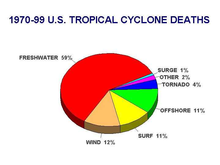
Between 1970-99, many more people have lost their lives in freshwater flooding associated with tropical cyclones than from storm surges (See graph below).
The slower a storm is moving, the greater the potential for extremely heavy rains and flooding Mountainous terrain also enhences the rainfall potential of a tropical cyclone. It is important to remember that tropical cyclones produce tremendous amounts of rain over inland areas and people need to prepare for this danger.
Outside of strong damaging winds and heavy rain, tropical cyclones can produce other types of severe weather. Most landfalling tropical cyclones produce tornadoes. Tropical Storm Mitch produced 3 tornadoes on the upper Keys in November 1998 causing significant damage and injuring 20 people.
NHC FORECASTS
The National Hurricane Center, NHC, in Miami, Florida, issues all watches/warnings and advisories for landfalling tropical cyclones in the U.S., and for of the countries in the Caribbean and Atlantic Ocean including Cuba and the virgin islands. For more information on the NHC go to http://www.nhc.noaa.gov
A WATCH means that hurricane or tropical storm conditions are possible in the specified area within 36 hours. A WARNING means that hurricane or tropical storm conditions are expected in the specified area within 24 hours. The NWS in Key West will issue a hurricane/tropical local statement to give greater detail on how the storm will affect the Keys and coastal waters. The NWS in Key West will also issue the short-term forecast to provide updates on the weather conditions associated with the storm in between the local statements as well as any severe weather warnings necessary during a storm's landfall.
NWR AND PREPAREDNESS
The best way to receive these and any NWS products is through NOAA Weather Radio (NWR) broadcasts. The broadcasts originate from the NWS office in Key West, FL. Other media sources such as TV, radio and newspapers are good ways to keep updated on tropical cyclone information as well.
It is important to develop a disaster plan for you and your family in case of a hurricane or tropical storm affecting the Keys. The NWS will always recommend safety precautions when issuing products during tropical cyclone events, but you have to decide what is best for you. See the FEMA's hurricane preparedness link under the tropical cyclone section for more detailed information on hurricane preparedness. If you would like more information, contact the NWS in Key West, Monroe County emergency management office or the local chapter of the Red Cross.

