
Numerous severe thunderstorms are expected across a broad region from the Ohio Valley to the Mid-Atlantic and Northeast States today into tonight. Swaths of damaging wind gusts are expected and some tornadoes are possible. Bertha is expected to bring tropical storm conditions to portions of the Gulf Coast from the Florida Panhandle westward to southeastern Louisiana later today and Wednesday. Read More >
Lake Charles, LA
Weather Forecast Office
| Hurricane Carla | ||
| September 3-13, 1961 | ||
|
|
||
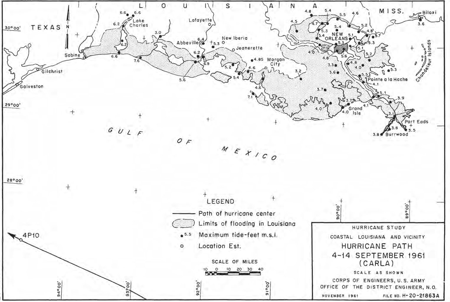
| Carla Storm Surge: Measured and High Water Marks Louisiana Map Sources: Louisiana U.S. Weather Bureau Post Storm Surveys U.S. Army Corp of Engineers Survey |
||||
 |
||||
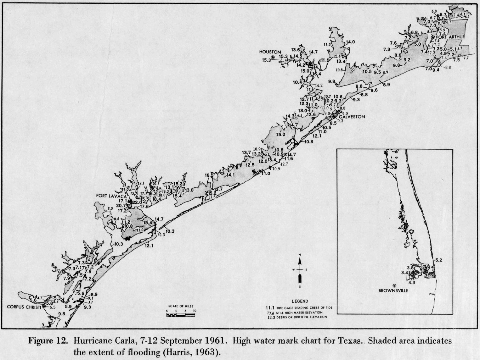
| Carla Storm Surge: Measured and High Water Marks Texas Map Sources: Verification Study of a Bathystrophic Storm Surge Model TECHNICAL MEMORANDUM - NO. 50 (May 1975) U.S. Army Corp of Engineers Survey |
||||
 |
||||
| Carla Storm Surge: Measured and High Water Marks Source: Texas and Louisiana U.S. Weather Bureau Post Storm Surveys U.S. Army Corp of Engineers Survey |
||||
| Location | Feet (MSL) | |||
| High Island, TX (staff gage) | 8.9 | |||
| Orange, TX (staff gage) | 7.4 | |||
| Port Arthur, TX (Texaco Tank Farm) (HWM) | 6.7 | |||
| Port Arthur/Orange Bridge, TX (crest gage) | 6.9 | |||
| Lake Sabine, TX (crest gage) | 7.2 | |||
| Port Arthur, TX Corp of Engineer Office (recorder) | 7.1 | |||
| Sabine Pass, TX Old Coast Guard Station (recorder) | 7.4 | |||
| Sabine Pass, TX Coast Guard Station (HWM) | 7.7 | |||
| Sabine Pass, TX West Jetty (HWM) | 8.8 | |||
| Sabine Pass, TX Keith Lake Gully (crest gage) | 7.3 | |||
| Cameron, LA (recorder) | 6.5 | |||
| Grand Chenier, LA (recorder) | 7.5 | |||
| Morgan City, LA (HWM) | 4.5 | |||
| Eugene Island, LA (HWM) | 7.1 | |||
Forecasts
Aviation Weather
Activity Planner
Mardi Gras Decision Support
Marine Forecasts
Local Products
Model Data
Forecaster's Discussion
Fire Weather
Graphical Forecasts
Wet Bulb Globe Temps
Other Links
National Hurricane Ctr
Storm Prediction Ctr
Weather Prediction Ctr
Other Links
Office History
LCH StoryMap
Hazards
Severe Weather
Tropical Weather
National Outlooks
Local Storm Reports
Tropical Cyclone Reports
Current
Observations
Tide Data
Satellite Data
Hydrology
Calcasieu Par. Network
Jefferson Co. DD6 Network
River/Lake Forecasts
Radar
Shreveport (SHV)
New Orleans (LIX)
Fort Polk (POE)
Houston/Galveston (HGX)
Lake Charles (LCH)
Probabilistic Pages
Probabilistic Snowfall
Probabilistic Rainfall
Probabilistic DSS
US Dept of Commerce
National Oceanic and Atmospheric Administration
National Weather Service
Lake Charles, LA
500 Airport Boulevard
Lake Charles, LA 70607
(337) 477-5285 M-F 8a to 4p only
Comments? Questions? Please Contact Us.

