|
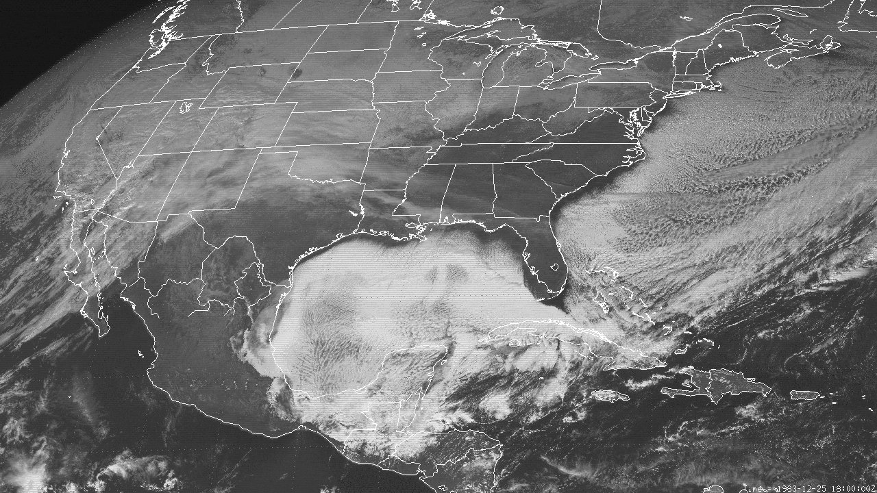
Above: GOES 5 Visible Satellite Image at 12:00 PM CST December 25, 1983 showing the cold air stratocumulus clouds over the Gulf and Atlantic.
A large mid to upper-level longwave trough over North America with large multiple cutoff lows within the trough axis over Canada persisted for most of the second half of December 1983. This allowed for several fridge Arctic airmasses to plunge southward across the Central and Eastern U.S. bringing record December cold to most locations.
The first Arctic airmass began intruding across Central & Southern Louisiana and Southeast Texas on December 22nd, bringing freezing temperatures to most of the area. A secondary larger and more frigid surface high plunged south southeast on December 23rd and brought record cold low temperatures in the single digits to lower teens on Christmas morning. With such a cold airmass moving over the warmer Gulf and Western Atlantic waters, cold air stratocumulus clouds prevailed just offshore the coastline over the entire Gulf and Western Atlantic, as shown by this GOES 5 Visible Satellite Image at 12:00 PM CST December 25th. Slowly moderating temperatures occurred on December 26th occurred with temperatures finally rising above freezing by the end of the day. Most locations across Louisiana north of I-10 and Southeast Texas remained below freezing around 111-115 hours from December 22nd through the 26th, which was a record for this area. Lake Charles and Lafayette Louisiana had 67 and 71 consecutive hours below freezing from the 23rd through the 26th, with only a few hours just above freezing from December 22nd through the 23rd.
By December 27th through the 28th, a weak surface low brought warmer temperatures in the 40s to lower 50s and rainfall across the area. No frozen precipitation occurred with the warmer temperatures. Due to the warmer and moist air interacting with the colder Gulf shelf waters, dense marine fog began invading the area during the early morning hours of December 27th and remained across the area through the afternoon of December 28th.
By December 28th, another dip southward within the large mid to upper-level longwave trough over North America allowed for another fridge surface high to plunge south southeast across the area late in the day. Temperatures once again fell below freezing for most of the period from December 29th through the 31st, with only a few hours just above freezing both afternoons. This brought record cold low temperatures in the lower to middle teens the morning of New Year’s Eve across the area. By New Year’s Day, a rapid warmup into the 50s occurred by the afternoon as the cold airmass moderated.
Due to the prolonged duration of temperatures below freezing and record cold temperatures, many frozen pipes burst in homes and businesses, causing severe water shortages across the area. Several fatalities were recorded across Louisiana and Texas, mainly to people with unheated homes.
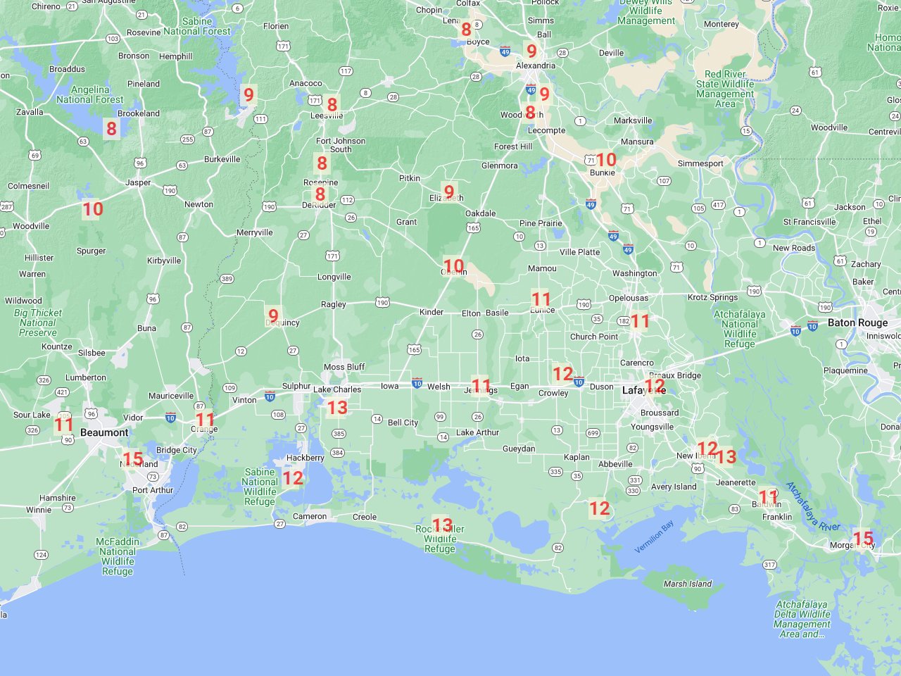
December 25, 1983 Record Low Temperatures
Compiled by: xmACIS2 |
 |
| STATE |
LOCATION |
STATION TYPE |
LOW |
| LA |
ALEXANDRIA |
COOP |
9 |
| LA |
BOYCE 3 WNW |
COOP |
8 |
| LA |
BUNKIE |
COOP |
10 |
| LA |
CROWLEY 2 NE |
COOP |
12 |
| LA |
DE QUINCY |
COOP |
9 |
| LA |
DE RIDDER |
COOP |
8 |
| LA |
ELIZABETH |
COOP |
9 |
| LA |
EUNICE |
COOP |
11 |
| LA |
FRANKLIN 3 NW |
COOP |
11 |
| LA |
GRAND COTEAU |
COOP |
11 |
| LA |
HACKBERRY 8 SSW |
COOP |
12 |
| LA |
JEANERETTE 5 NW |
COOP |
13 |
| LA |
JENNINGS |
COOP |
11 |
| LA |
LAFAYETTE REGIONAL AIRPORT |
WBAN |
12 |
| LA |
LAKE CHARLES REGIONAL AIRPORT |
WBAN |
13 |
| LA |
LEESVILLE |
COOP |
8 |
| LA |
LELAND BOWMAN LOCK |
COOP |
12 |
| LA |
LSU DEAN LEE RESEARCH STATION |
COOP |
9 |
| LA |
MORGAN CITY |
COOP |
15 |
| LA |
NEW IBERIA |
COOP |
12 |
| LA |
OBERLIN FIRE TOWER |
COOP |
10 |
| LA |
ROCKEFELLER WILDLIFE REFUGE |
COOP |
13 |
| LA |
ROSEPINE RESEARCH STATION |
COOP |
8 |
| LA |
WOODWORTH 2 SE |
COOP |
8 |
| TX |
BEAUMONT RESEARCH CENTER |
COOP |
11 |
| TX |
ORANGE |
COOP |
11 |
| TX |
PORT ARTHUR SE TX REGIONAL AIRPORT |
WBAN |
15 |
| TX |
SAM RAYBURN DAM |
COOP |
8 |
| TX |
TOLEDO BEND DAM |
COOP |
9 |
| TX |
TOWN BLUFF DAM |
COOP |
10 |
| Consecutive hours below freezing |
| Location |
Start Date/Time |
End Date/Time |
Hours |
| Fort Polk, LA (KPOE-Army) |
12/22 - 5 AM |
12/26 - 11 PM |
115 |
| Alexandria Esler Field, LA (KESF-WBAN) |
12/22 - 9 AM |
12/26 - 11 PM |
111 |
| Lake Charles Regional Airport, LA (KLCH-NWS) |
12/23 - 10 PM |
12/26 - 5 PM |
67 |
| Lafayette, LA (KLFT-WBAN) |
12/23 - 5 PM |
12/26 - 4 PM |
71 |
| Port Arthur Southeast Texas Regional Airport, TX (KBPT-NWS) |
12/22 - 6 AM |
12/26 - 9 PM |
*111 |
| *Had 1 hour above freezing (33) on 12/23/1983. |
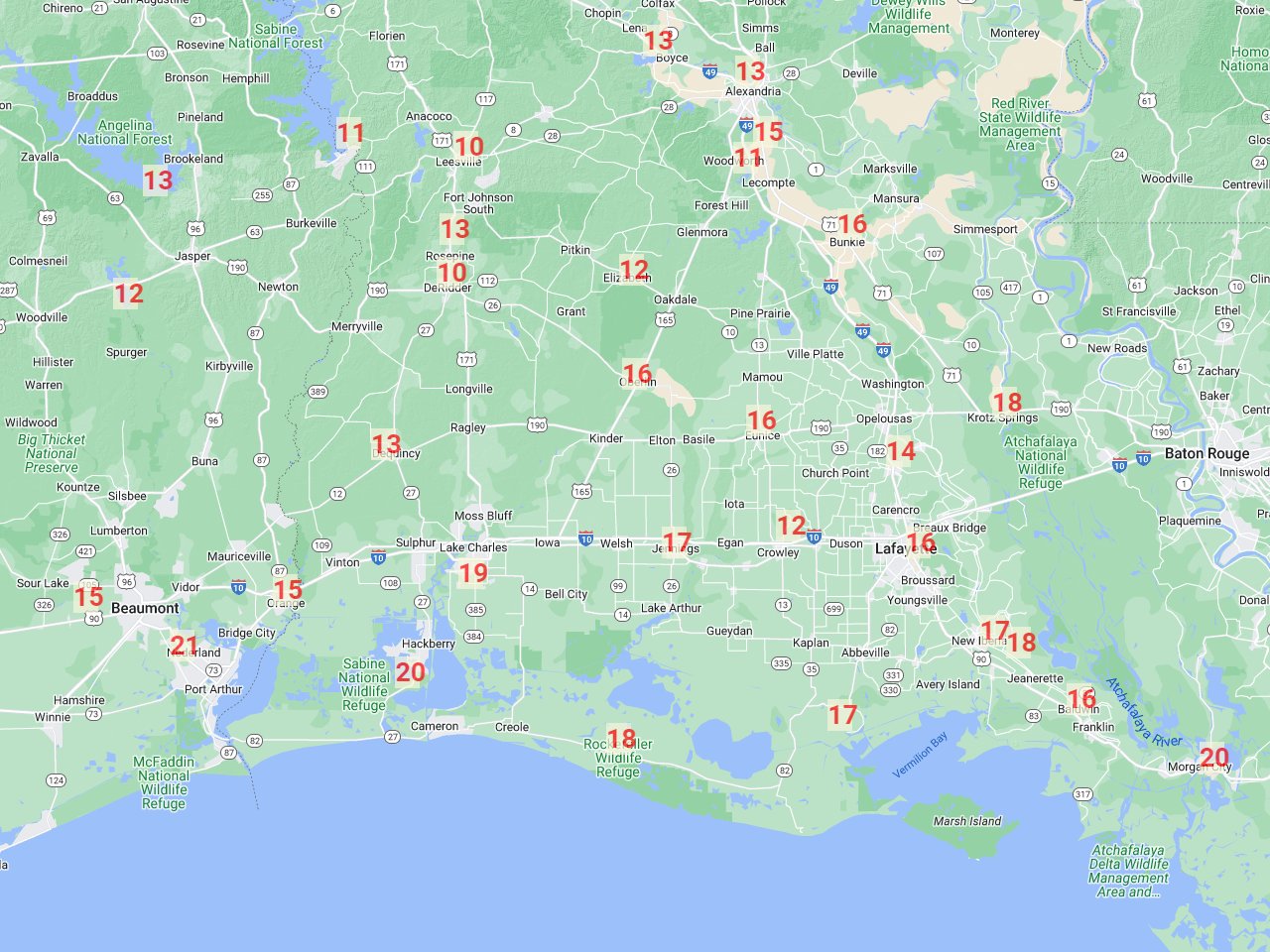
December 31, 1983 Record Low Temperatures
Compiled by: xmACIS2 |
 |
| STATE |
LOCATION |
STATION TYPE |
LOW |
| LA |
ALEXANDRIA |
COOP |
13 |
| LA |
BOYCE 3 WNW |
COOP |
13 |
| LA |
BUNKIE |
COOP |
16 |
| LA |
CROWLEY 2 NE |
COOP |
12 |
| LA |
DE QUINCY |
COOP |
13 |
| LA |
DE RIDDER |
COOP |
10 |
| LA |
ELIZABETH |
COOP |
12 |
| LA |
EUNICE |
COOP |
16 |
| LA |
FRANKLIN 3 NW |
COOP |
16 |
| LA |
GRAND COTEAU |
COOP |
14 |
| LA |
HACKBERRY 8 SSW |
COOP |
20 |
| LA |
JEANERETTE 5 NW |
COOP |
18 |
| LA |
JENNINGS |
COOP |
17 |
| LA |
KROTZ SPRINGS |
COOP |
18 |
| LA |
LAFAYETTE REGIONAL AIRPORT |
WBAN |
16 |
| LA |
LAKE CHARLES REGIONAL AIRPORT |
WBAN |
19 |
| LA |
LEESVILLE |
COOP |
10 |
| LA |
LELAND BOWMAN LOCK |
COOP |
17 |
| LA |
LSU DEAN LEE RESEARCH STATION |
COOP |
15 |
| LA |
MORGAN CITY |
COOP |
20 |
| LA |
NEW IBERIA |
COOP |
17 |
| LA |
OBERLIN FIRE TOWER |
COOP |
16 |
| LA |
ROCKEFELLER WILDLIFE REFUGE |
COOP |
18 |
| LA |
ROSEPINE RESEARCH STATION |
COOP |
13 |
| LA |
WOODWORTH 2 SE |
COOP |
11 |
| TX |
BEAUMONT RESEARCH CENTER |
COOP |
15 |
| TX |
ORANGE |
COOP |
15 |
| TX |
PORT ARTHUR SE TX REGIONAL AIRPORT |
WBAN |
21 |
| TX |
SAM RAYBURN DAM |
COOP |
13 |
| TX |
TOLEDO BEND DAM |
COOP |
11 |
| TX |
TOWN BLUFF DAM |
COOP |
12 |
Webpage design and content by: Donovan Landreneau
|


