
Wildfires and poor air quality continue for the Pacific Northwest, Rockies and extended into the Plains. Severe thunderstorms possible for the northern Plains and upper Midwest on Monday along a frontal boundary. Another boundary will focus showers and thunderstorms for the eastern seaboard with localized heavy rainfall possible. For Alaska, a strong Bering Sea storm will bring winds and rainfall. Read More >
Lake Charles, LA
Weather Forecast Office
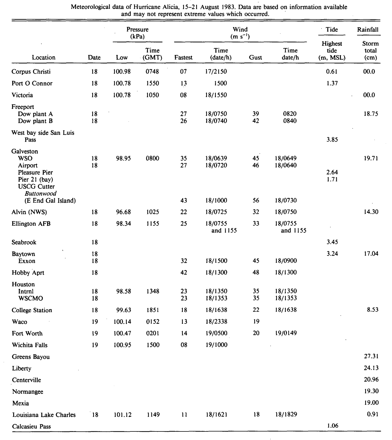
| Hurricane Alicia | ||
| August 15-21, 1983 | ||
|
|
||
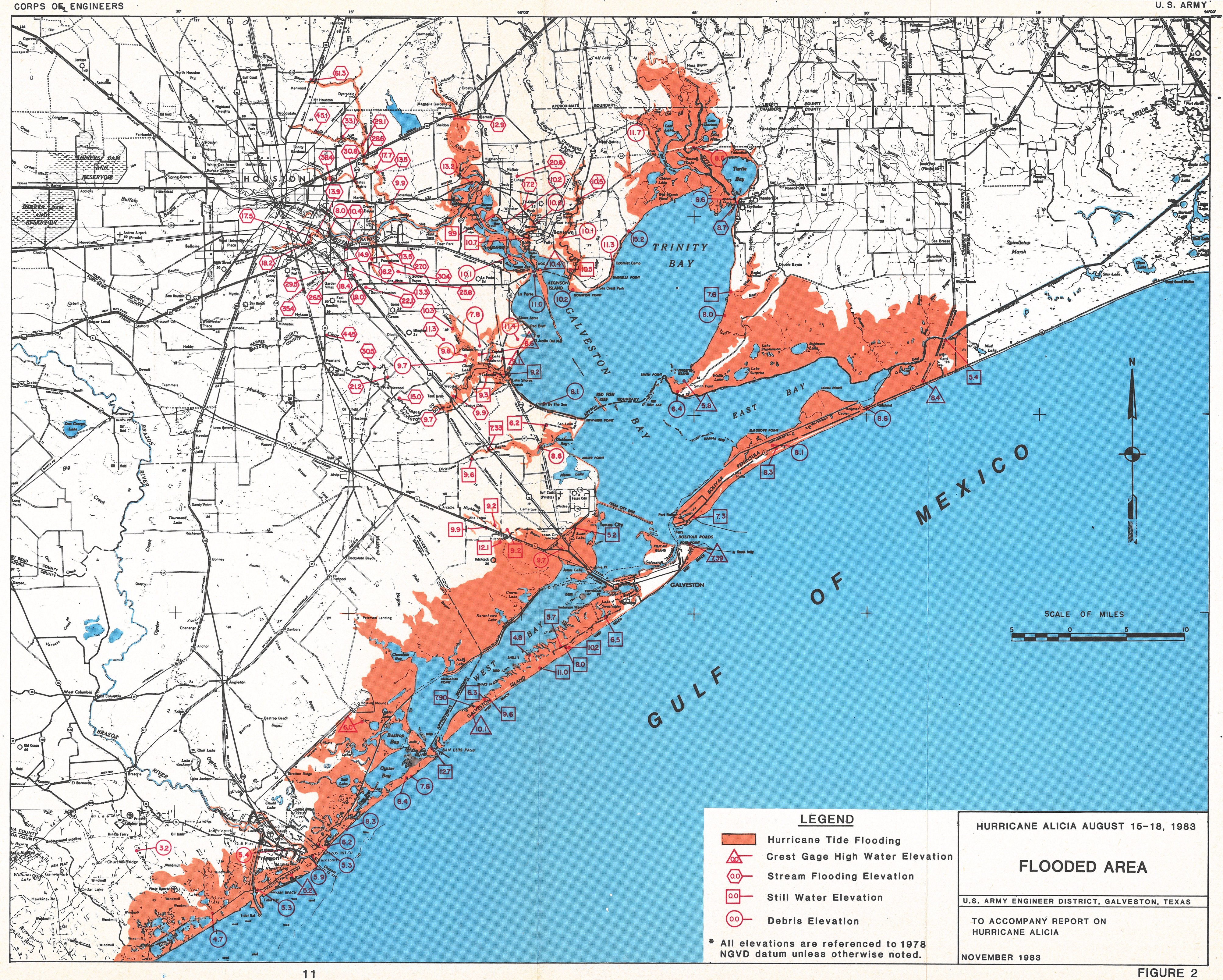
| Alicia Storm Surge: Measured and High Water Marks Texas Map Source: Hurricane Alicia 15-18 August 1983 U.S. Army Engineer District, Galveston, TX Corp of Engineers (November 1983) |
||||
 |
||||
|
Alicia Storm Surge: Measured and High Water Marks |
||||
| Location | Feet (MSL) | |||
| Cameron, LA | 3.5 | |||
| Sabine Pass, TX | 4.2 | |||
| Galveston Pleasure Pier, TX | 8.7 | |||
| Galveston Pier 21, TX | 5.6 | |||
| Seabrook, TX | 11.3 | |||
| Baytown, TX | 10.6 | |||
| San Luis Pass, TX | 12.6 | |||
| Port O'Connor, TX | 4.5 | |||
| Corpus Christi, TX | 2.0 | |||
Forecasts
Graphical Forecasts
Wet Bulb Globe Temps
Aviation Weather
Activity Planner
Mardi Gras Decision Support
Marine Forecasts
Local Products
Model Data
Forecaster's Discussion
Fire Weather
Other Links
National Hurricane Ctr
Storm Prediction Ctr
Weather Prediction Ctr
Other Links
Office History
LCH StoryMap
Hazards
Severe Weather
Tropical Weather
National Outlooks
Local Storm Reports
Tropical Cyclone Reports
Current
Satellite Data
Observations
Tide Data
Hydrology
Calcasieu Par. Network
Jefferson Co. DD6 Network
River/Lake Forecasts
Radar
Shreveport (SHV)
New Orleans (LIX)
Fort Polk (POE)
Houston/Galveston (HGX)
Lake Charles (LCH)
Probabilistic Pages
Probabilistic DSS
Probabilistic Snowfall
Probabilistic Rainfall
US Dept of Commerce
National Oceanic and Atmospheric Administration
National Weather Service
Lake Charles, LA
500 Airport Boulevard
Lake Charles, LA 70607
(337) 477-5285 M-F 8a to 4p only
Comments? Questions? Please Contact Us.

