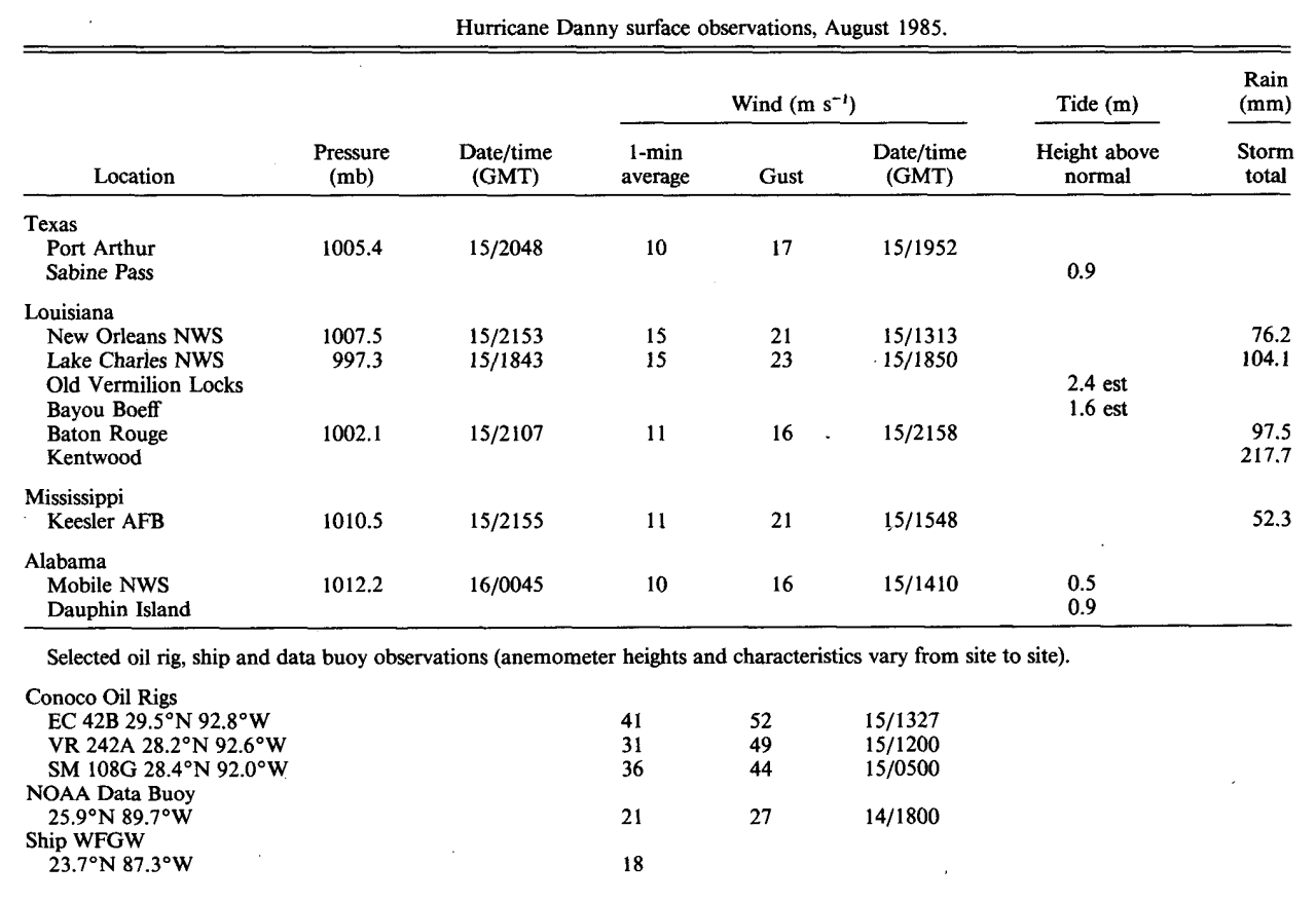
Wind and Pressure Reports
Sources: National Weather Service Post Storm Reports
National Centers for Environmental Information (NECI)
Monthly Weather Review - 1985 Atlantic Hurricane Season
Monthly Weather Review Meteorological Data of Hurricane Danny (Note: All data in metric system) |
| Location |
Minimal Sea Level Pressure |
Maximum Sustained Wind (1 Min. Avg.) |
Peak Wind Gust |
Corpus Christi, TX
(KCRP-NWS) |
1009.1 mb (29.80")
8/15 @ 11:30 PM CDT |
22 mph (19 knots)
8/15 @ 12:50 PM CDT |
24 mph (21 knots)
8/15 @ 1:02 PM CDT |
Port Arthur, TX
(KBPT-NWS) |
1005.4 mb (29.69")
8/15 @ 3:48 PM CDT |
22 mph (19 knots)
8/15 @ 2:52 PM CDT |
37 mph (32 knots)
8/15 @ 2:52 PM CDT |
Sea Rim State Park, TX
(SRST2-NDBC) |
1006.0 mb (29.70")
8/15 @ 4:00 PM CDT |
(*) 19 mph (16 knots)
8/15 @ 11:00 AM CDT |
24 mph (21 knots)
8/15 @ 11:00 AM CDT |
Lake Charles, LA
(KLCH-NWS) |
997.3 mb (29.45")
8/15 @ 1:43 PM CDT |
35 mph (30 knots)
8/15 @ 1:50 PM CDT |
52 mph (45 knots)
8/15 @ 1:52 PM CDT |
| Cameron, LA |
998.3 mb (29.48")
8/15 @ 11:15 AM CDT |
|
53 mph (46 knots)
8/15 @ 9:38 AM CDT |
Near Cameron/Vermilion Parish line along Hwy 82 between Pecan Island and Rockefeller Wildlife Refuge, LA
Observer: Terry Nixon
(29.7°N, 92.7°W) |
989.5 mb (29.22")
8/15 @ 11:15 AM CDT |
(**) 51 mph (44 knots)
8/15 @ 2:06 PM CDT |
(**) 75 mph (65 knots)
8/15 @ 2:03 PM CDT |
Lafayette, LA
(KLFT-WBAN) |
(I) 997.3 mb (29.45")
8/15 @ 3:00 PM CDT |
(I) 34 mph (30 knots)
8/15 @ 2:00 PM CDT |
(I) 57 mph (50 knots)
8/15 @ 2:00 PM CDT |
Alexandria (Esler), LA
(KESF-WBAN) |
(I) 994.6 mb (29.37")
8/15 @ 8:00 PM CDT |
(I) 34 mph (30 knots)
8/15 @ 6:00 PM CDT |
(I) 55 mph (48 knots)
8/15 @ 7:37 PM CDT |
Fort Polk, LA
(KPOE-Army Base) |
1000.7 mb (29.55")
8/15 @ 5:00 PM CDT |
20 mph (17 knots)
8/15 @ 6:00 PM CDT |
32 mph (28 knots)
8/15 @ 4:00 PM CDT |
Baton Rouge, LA
(KBTR-NWS) |
1002.0 mb (29.59")
8/15 @ 4:07 PM CDT |
25 mph (22 knots)
8/15 @ 4:58 PM CDT |
36 mph (31 knots)
8/15 @ 4:58 PM CDT |
New Orleans, LA
(KMSY-WBAN) |
1007.5 mb (29.75")
8/15 @ 4:53 PM CDT |
35 mph (30 knots)
8/15 @ 8:13 AM CDT |
46 mph (40 knots)
8/15 @ 4:12 AM CDT |
Keesler AFB, MS
(KBIX-AFB) |
|
|
49 mph (43 knots)
8/15 @ 1:00 PM CDT |
Mobile, AL
(KMOB-NWS) |
1012.5 mb (29.90")
8/15 @ 7:45 PM CDT |
21 mph (18 knots)
8/15 @ 9:10 AM CDT |
35 mph (30 knots)
8/15 @ 1:54 PM CDT |
Selected Oil Rig Reports
(anemometer heights and characteristics vary from site to site, listed if available) |
| Location |
Minimal Sea Level Pressure |
Maximum Sustained Wind (1 Min. Avg.) |
Peak Wind Gust |
EC 42B
(29.5°N, 92.8°W)
(70 feet) |
|
92 mph (80 knots)
8/15 @ 8:27 AM CDT |
116 mph (101 knots)
8/15 @ 8:27 AM CDT |
GRD CHN
(29.8°N, 93.0°W) |
|
52 mph (45 knots)
8/15 @ 1:00 PM CDT |
65 mph (57 knots)
8/15 @ 1:00 PM CDT |
WC 66C
(29.7°N, 93.1°W)
(70 feet) |
|
69 mph (60 knots)
8/15 @ 12:00 PM CDT |
85 mph (74 knots)
8/15 @ 12:00 PM CDT |
SM 108G
(28.4°N, 92.0°W)
(80 feet) |
|
81 mph (70 knots)
8/15 @ 12:00 AM CDT |
98 mph (85 knots)
8/15 @ 12:00 AM CDT |
SS 158C
(28.7°N, 91.0°W) |
|
75 mph (65 knots)
8/15 @ 2:00 AM CDT |
92 mph (80 knots)
8/15 @ 2:00 AM CDT |
SM 136B
(28.2°N, 92.0°W) |
|
69 mph (60 knots)
8/15 @ 6:00 AM CDT |
74 mph (64 knots)
8/15 @ 6:00 AM CDT |
VR 242A
(28.6°N, 92.6°W)
(90 feet) |
|
69 mph (60 knots)
8/15 @ 7:00 AM CDT |
110 mph (96 knots)
8/15 @ 7:00 AM CDT |
(E) = Estimated
(I) = Incomplete
(*) = Maximum Sustained Wind (2 Min. Avg.)
(**) = Anemometer 10 feet above ground. |


