|

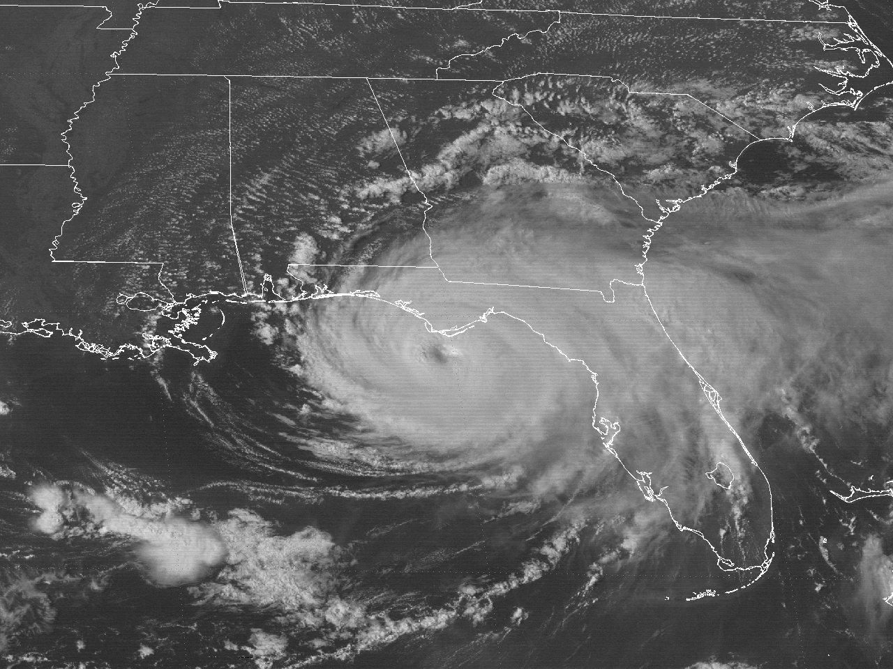
Above: GOES-6 visible satellite image of Hurricane Elena at landfall across Southern Mississippi at 7:31 AM CDT September 2, 1985.
Hurricane Elena originated from a well-organized tropical wave that emerged off the African coast on August 23rd. A strong mid to upper level subtropical ridge building westward across the Atlantic steered the wave at an unusually rapid westward motion of 35 mph the next 3 days. The rapid motion, and the wave being embedded within a Saharan Dust layer, initially inhibited development.
By August 26th, showers and thunderstorms increased in organization as the wave approached the northern Leeward Island, and continued westward over Puerto Rico, Dominican Republic, and Haiti. As the disturbance approached Eastern Cuba the evening of August 27th, Air Force Reconnaissance aircraft found enough organization to be classified as Tropical Depression #5, despite the system moving to the west northwest at 25 to 30 mph. The depression continued to move over Cuba the rest of that evening through August 28th. Satellite and Key West, FL radar continued to show increasing organization, and the system was upgraded to Tropical Storm Elena by early afternoon. Elena quickly emerged across the Southeastern Gulf by that evening.
The mid to upper level ridge of high pressure from Bermuda to the Carolinas allowed Tropical Storm Elena to turn more to the northwest around 20 mph and strengthen over the Eastern Gulf on August 29th. By daybreak, Air Force Reconnaissance aircraft found Elena had reached hurricane strength. Elena continued to strengthen across the Eastern Gulf as the system continued to move northwest and gradually slowdown in forward speed.
By daybreak on August 30th, Elena had intensified to a category 2 hurricane. A digging upper level trough over the Eastern United States essentially eroded the steering currents over the Eastern Gulf and Elena’s northward motion halted to less than 5 mph. Elena continued to drift erratically northeastward that evening, and eastward on August 31st towards the west coast of Florida. Elena stalled by that evening as the mid to upper level trough over the Eastern United States lifted northeast. Elena continued to move erratically, eventually making a small clockwise loop overnight through the late morning hours of September 1st, and continued to strengthen. By daybreak that morning, NOAA Reconnaissance aircraft found Elena had reached major hurricane intensity.
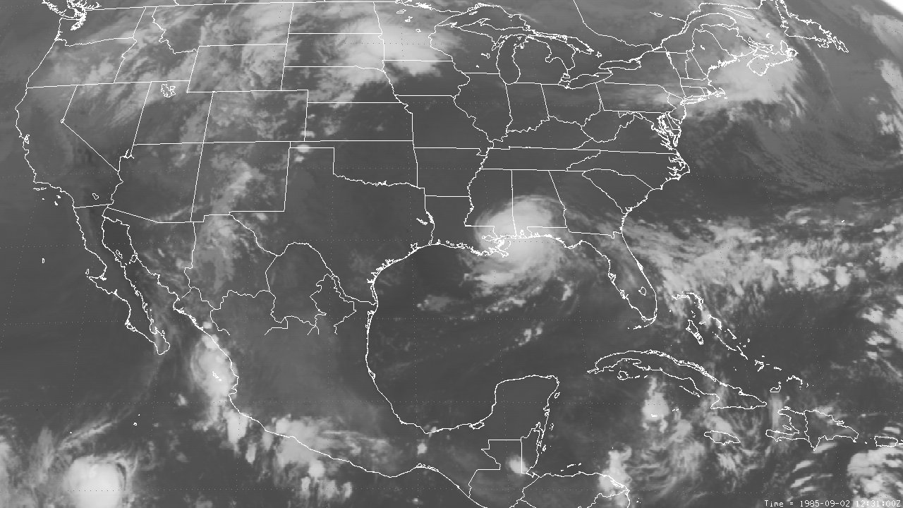
A strengthening mid to upper level ridge over the Central United States continued to build eastward, and began to steer Elena west northwest around 10 just south of the Florida Panhandle. Elena continued to strengthen with maximum sustained winds of 125 mph (110 knots) and a minimum sea level pressure of 951 millibars (28.08 inches) as it passed 40 miles southwest of Apalachicola, Florida. A GOES-6 visible satellite image at 5:01 PM EDT September 1st shows Elena at this peak intensity.
Elena continued to move to the west northwest at 10 to 15 mph during the evening of September 1st through the early morning hours of September 2nd, passing just south of Dauphin Island, Alabama, and through the Barrier Islands off the Mississippi coast. Hurricane Elena made landfall near Gulfport, Mississippi shortly before 8 AM CDT September 2nd with maximum sustained winds of 115 mph (100 knots) and a minimum sea level pressure of 959 millibars (28.32 inches). GOES-6 visible and infrared satellite image at 7:31 AM CDT September 2nd shows Elena making landfall across the Mississippi Coast.
Elena continued to move west northwest around 15 mph across southern Mississippi and weakened to a category one hurricane as it crossed into Southeast Louisiana. Elena weakened to a tropical storm by 1 PM CDT as it once again entered Mississippi south of Magnolia. Elena continued to weaken as it crossed over Natchez, Mississippi and entered Northeast Louisiana. Elena weakened to a tropical depression between Shreveport and Monroe Louisiana during the early morning hours of September 3rd, and continued through the ArkLaTex before turning northward across Western Arkansas later that afternoon. Elena eventually dissipated over Eastern Missouri the afternoon of September 4th. Click here for an interactive track of Hurricane Elena.
Hurricane Elena’s slow erratic motion from August 30th through September 1st created major forecasting and evacuation problems during the Labor Day weekend. Hurricane warnings were issued from Morgan City, Louisiana eastward to Sarasota, Florida, with the area from Southeast Louisiana to the Florida Panhandle under a hurricane warning on two different occasions. This prompted massive evacuations from Southeast Louisiana to the Florida Panhandle, and in some cases, twice during the Labor Day weekend.
WIND & PRESSURE:
For our region west of the Atchafalaya River, no tropical storm force winds were observed. The tropical storm and hurricane force winds were confined to the Florida, Alabama, Mississippi, and areas of Louisiana north of New Orleans. For complete meteorological statistics, see the Wind and Pressure section.
STORM SURGE:
For our region west of the Atchafalaya River, no significant coastal flooding was recorded. For other storm surge and high-water marks, see the Storm Surge section.
RAINFALL:
Rainfall ranged from 3 to almost 8 inches across Central and South-Central Louisiana, with one half to 3 inches across Southwest Louisiana and Southeast Texas. Most of the rainfall occurred with the remnant moisture that lingered across the region several days after landfall. The highest total of 7.88 inches was recorded in Bunkie, Louisiana. For complete rainfall totals reported across our region, see the Rainfall section.
TORNADOES:
No tornadoes were reported in Louisiana.
|


