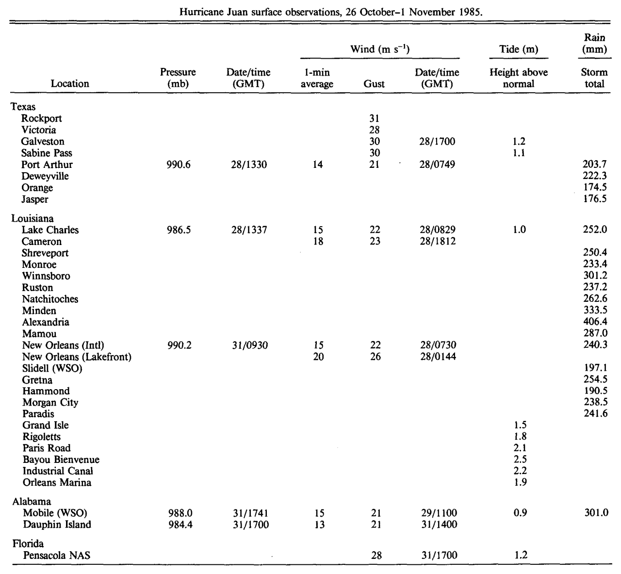
Wind and Pressure Reports
Sources: National Weather Service Post Storm Reports
National Centers for Environmental Information (NECI)
Monthly Weather Review - 1985 Atlantic Hurricane Season
Monthly Weather Review Meteorological Data of Hurricane Juan (Note: All data in metric system) |
| Location |
Minimal Sea Level Pressure |
Maximum Sustained Wind (1 Min. Avg.) |
Peak Wind Gust |
Galveston, TX
(KGLS-WBAN) |
997.0 mb (29.44")
10/28 @ 7:00 AM CST |
38 mph (33 knots)
10/28 @ 12:30 PM CST |
49 mph (42 knots)
10/28 @ 11:30 AM CST |
Sea Rim State Park, TX
(SRST2-NDBC) |
989.7 mb (29.23")
10/28 @ 1:00 PM CST |
(*) 35 mph (30 knots)
10/28 @ 5:00 PM CST |
46 mph (40 knots)
10/28 @ 3:00 PM CST |
Port Arthur, TX
(KBPT-NWS) |
990.6 mb (29.25")
10/28 @ 7:30 AM CST |
31 mph (27 knots)
10/28 @ 1:49 AM CST |
47 mph (41 knots)
10/28 @ 1:49 AM CST |
Lake Charles, LA
(KLCH-NWS) |
986.5 mb (29.13")
10/28 @ 7:37 AM CST |
35 mph (30 knots)
10/28 @ 2:29 AM CST |
49 mph (43 knots)
10/28 @ 2:23 AM CST |
| Cameron, LA |
|
40 mph (35 knots)
10/28 @ 12:13 PM CST |
52 mph (45 knots)
10/28 @ 12:12 PM CST |
Lafayette, LA
(KLFT-WBAN) |
982.1 mb (29.00")
10/29 @ 12:00 PM CST |
25 mph (22 knots)
10/28 @ 7:00 AM CST |
34 mph (30 knots)
10/28 @ 7:00 AM CST |
Fort Polk, LA
(KPOE-Army Base) |
992.6 mb (29.31")
10/29 @ 2:00 PM CST |
31 mph (27 knots)
10/28 @ 7:00 AM CST |
46 mph (40 knots)
10/28 @ 4:00 AM CST |
Alexandria (Esler), LA
(KESF-WBAN) |
991.9 mb (29.29")
10/29 @ 2:00 PM CST |
30 mph (26 knots)
10/28 @ 7:00 AM CST |
49 mph (43 knots)
10/28 @ 9:00 AM CST |
Baton Rouge, LA
(KBTR-NWS) |
988.5 mb (29.19")
10/29 @ 8:00 AM CST |
29 mph (25 knots)
10/28 @ 3:42 AM CST |
39 mph (34 knots)
10/28 @ 5:00 AM CST |
New Orleans, LA
International
(KMSY-WBAN) |
990.2 mb (29.24")
10/31 @ 3:30 AM CST |
35 mph (30 knots)
10/28 @ 1:30 AM CST |
49 mph (43 knots)
10/27 @ 8:24 PM CST |
New Orleans, LA
Lakefront
(KNEW-WBAN) |
989.8 mb (29.23")
10/31 @ 4:00 AM CST |
44 mph (38 knots)
10/27 @ 7:44 PM CST |
59 mph (51 knots)
10/27 @ 7:27 PM CST |
Biloxi Keesler AFB, MS
(KBIX-WBAN) |
990.2 mb (29.24")
10/31 @ 1:00 PM CST |
23 mph (20 knots)
10/29 @ 10:00 AM CST |
43 mph (37 knots)
10/29 @ 10:00 AM CST |
Mobile, AL
(KMOB-NWS) |
988.0 mb (29.18")
10/31 @ 11:41 AM CST |
34 mph (29 knots)
10/29 @ 5:00 AM CST |
47 mph (41 knots)
10/29 @ 5:00 AM CST |
| Dauphin Island, AL |
984.4 mb (29.07")
10/31 @ 11:00 AM CST |
29 mph (25 knots)
10/31 @ 8:00 AM CST |
47 mph (41 knots)
10/31 @ 8:00 AM CST |
Pensacola NAS, FL
(KNPA-WBAN) |
983.4 mb (29.04")
10/31 @ 1:00 PM CST |
47 mph (41 knots)
10/31 @ 1:07 PM CST |
63 mph (55 knots)
10/31 @ 1:07 PM CST |
(E)=Estimated
(I) =Incomplete
(*) = Maximum Sustained Wind (2 Min. Avg.) |


