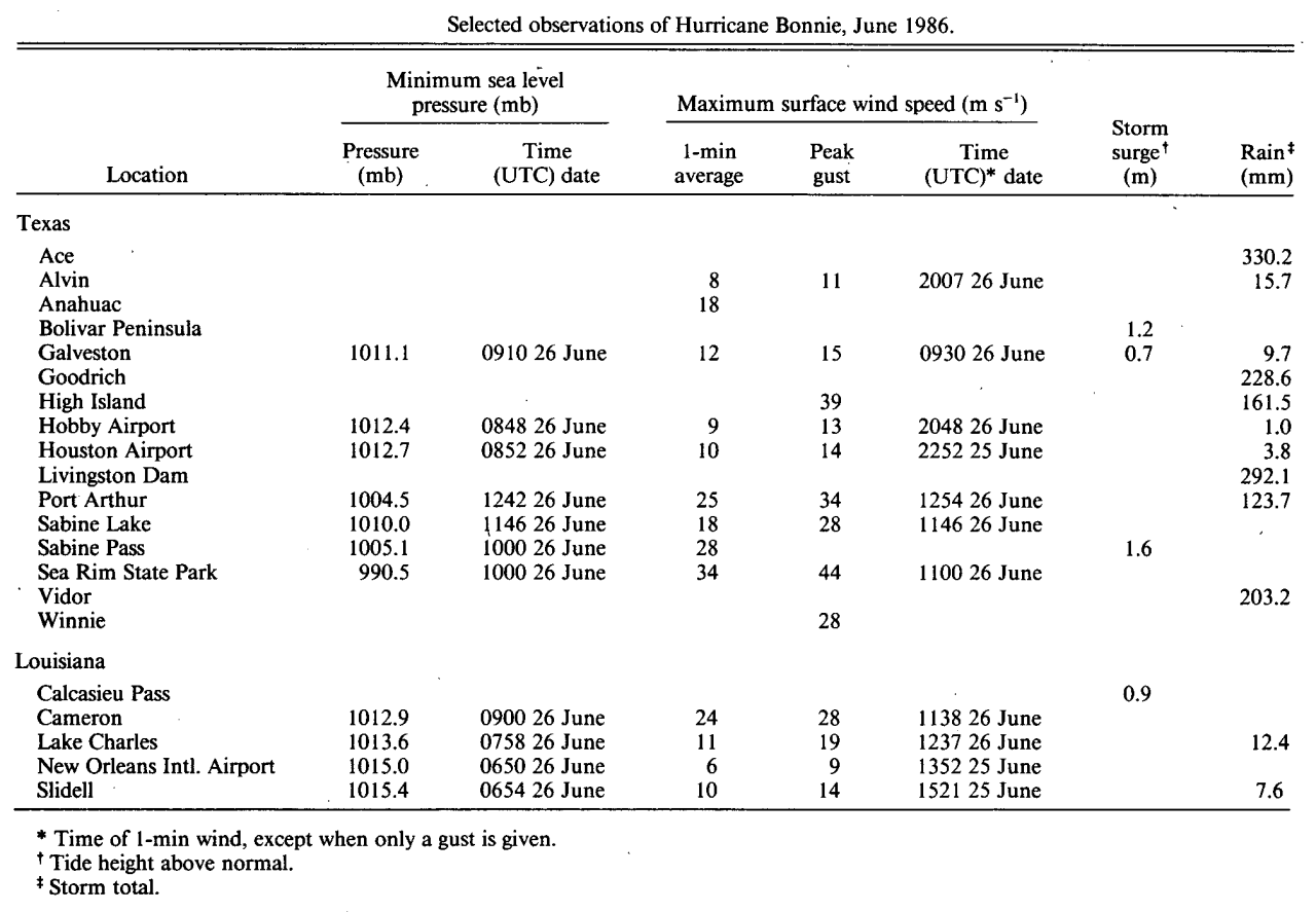
Wind and Pressure Reports
Sources: National Weather Service Post Storm Reports
National Centers for Environmental Information (NECI)
Monthly Weather Review - 1986 Atlantic Hurricane Season
Monthly Weather Review Meteorological Data of Hurricane Bonnie (Note: All data in metric system) |
| Location |
Minimal Sea Level Pressure |
Maximum Sustained Wind (1 Min. Avg.) |
Peak Wind Gust |
Galveston, TX
(NWS) |
1011.1 mb (29.86")
6/26 @ 4:10 AM CDT |
28 mph (24 knots)
6/26 @ 4:30 AM CDT |
35 mph (30 knots)
6/26 @ 4:11 AM CDT |
Alvin, TX
(NWS) |
|
18 mph (16 knots)
6/26 @ 3:07 PM CDT |
24 mph (21 knots)
6/26 @ 3:07 PM CDT |
Houston (Intrnl.), TX
(KIAH-WBAN) |
1012.7 mb (29.91")
6/26 @ 3:52 AM CDT |
23 mph (20 knots)
6/25 @ 5:52 PM CDT |
32 mph (28 knots)
6/25 @ 5:43 PM CDT |
Houston (Hobby), TX
(KHOU-WBAN) |
1012.4 mb (29.90")
6/26 @ 3:48 AM CDT |
21 mph (18 knots)
6/26 @ 3:48 PM CDT |
29 mph (25 knots)
6/26 @ 3:48 PM CDT |
Port Arthur, TX
(KBPT-NWS) |
1004.5 mb (29.66")
6/26 @ 7:42 AM CDT |
55 mph (48 knots)
6/26 @ 7:54 AM CDT |
76 mph (66 knots)
6/26 @ 7:46 AM CDT |
| High Island, TX |
|
(E) 85 mph (74 knots) |
|
| Winnie, TX |
|
(E) 65 mph (57 knots) |
|
Sea Rim State Park, TX
(SRST2-NDBC) |
990.5 mb (29.25")
6/26 @ 5:00 AM CDT |
(*) 77 mph (67 knots)
6/26 @ 6:00 AM CDT |
98 mph (85 knots)
6/26 @ 6:00 AM CDT |
| Sabine Pass, TX |
1005.1 mb (29.68")
6/26 @ 5:00 AM CDT |
63 mph (55 knots) |
|
| NW Sabine Lake, TX |
1010.0 mb (29.68")
6/26 @ 6:46 AM CDT |
40 mph (35 knots)
6/26 @ 6:46 AM CDT |
63 mph (55 knots)
6/26 @ 6:46 AM CDT |
Lake Charles, LA
(KLCH-NWS) |
1013.6 mb (29.93")
6/26 @ 2:58 AM CDT |
25 mph (22 knots)
6/26 @ 7:37 AM CDT |
41 mph (36 knots)
6/26 @ 6:02 AM CDT |
| Cameron, LA |
1012.9 mb (29.91")
6/26 @ 5:00 AM CDT |
54 mph (47 knots)
6/26 @ 6:38 AM CDT |
62 mph (54 knots)
6/26 @ 5:25 AM CDT |
Lafayette, LA
(KLFT-WBAN) |
1014.9 mb (29.97")
6/25 @ 3:00 AM CDT |
21 mph (18 knots)
6/26 @ 12:58 PM CDT |
|
Alexandria (Esler), LA
(KESF-WBAN) |
1015.2 mb (29.98")
6/25 @ 10:00 AM CDT |
17 mph (15 knots)
6/26 @ 9:00 AM CDT |
25 mph (22 knots)
6/26 @ 3:22 AM CDT |
Fort Polk, LA
(KPOE-Army Base) |
1014.6 mb (29.96")
6/25 @ 11:00 AM CDT |
16 mph (14 knots)
6/26 @ 11:00 AM CDT |
26 mph (23 knots)
6/26 @ 7:00 AM CDT |
Baton Rouge, LA
(KBTR-NWS) |
1015.6 mb (29.99")
6/25 @ 2:00 AM CDT |
15 mph (13 knots)
6/26 @ 9:00 AM CDT |
|
New Orleans, LA
(KMSY-WBAN) |
1015.4 mb (29.98")
6/25 @ 1:54 AM CDT |
22 mph (19 knots)
6/25 @ 10:21 AM CDT |
32 mph (28 knots)
6/25 @ 10:36 AM CDT |
New Orleans, LA
(KNEW-WBAN) |
1015.0 mb (29.97")
6/25 @ 1:50 AM CDT |
14 mph (12 knots)
6/25 @ 8:52 AM CDT |
20 mph (17 knots)
6/25 @ 10:50 AM CDT |
(E) = Estimated
(I) = Incomplete
(*) = Maximum Sustained Wind (2 Min. Avg.) |


