|
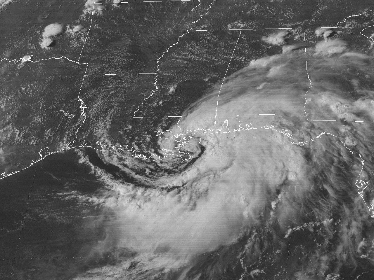
Above: GOES-7 visible satellite image of Tropical Storm Beryl off the Southeast Louisiana Coast at 4:01 PM CDT August 8, 1988.
Beryl had its origin from a broad surface trough that extended from the Northeast Gulf through the Mid-Atlantic States on August 1st. The southwestern portion of the surface trough over the Gulf began to drift west and formed a mid-level circulation just south of the Florida Panhandle on August 3rd. The first signs of a surface circulation occurred late in the afternoon of August 3rd just off the Mississippi Coast. The weak surface low drifted very slowly west off the Mississippi and Southeast Louisiana coast the next several days, with persistent rounds of thunderstorms from Southern Louisiana, Mississippi, and Alabama. By August 7th, the surface low gradually became better organized across Southeast Louisiana while centered near Lake Pontchartrain, where it was designated Tropical Depression #3 by the early evening hours. High pressure aloft provided better outflow, but little steering of the tropical depression as it initially drifted to the southeast.
During the early morning hours of August 8th, the depression continued to drift southeast and moved just offshore of the marshes of Southeast Louisiana. Ship reports and oil rigs across the area reported increasing winds to minimal tropical storm force, thus Tropical Depression #3 was upgraded to Tropical Storm Beryl at the 5 AM CDT advisory. Beryl continued to drift southeast along the Mississippi River delta for the remainder of the day, gradually becoming better organized. By the evening hours, Beryl began to drift to the west northwest as a result of a southward digging mid to upper level trough over the Midwest and the mid to upper high pressure cell shifting eastward.
Tropical Storm Beryl attained a maximum intensity of 50 mph (45 knots) and a minimum central pressure of 1001 millibars (29.56 inches) as it made landfall across the marshes of Southeast Louisiana south of Shell Beach shortly after 1 AM CDT August 9th, and moved across the New Orleans Metropolitan area during the predawn hours. Beryl continued to move to the west northwest further inland just south of Baton Rouge, Louisiana, and weakened to a tropical depression just before sunset that evening as it was crossing the Atchafalaya River just east of Butte La Rose. Moving northwest, Tropical Depression Beryl continued across South Central and Central Louisiana that evening into the morning hours of August 10th, and dissipated across Northwest Louisiana later that evening. Click here for an interactive track of Tropical Storm Beryl.
WIND & PRESSURE:
No tropical storm force winds were observed west of the Atchafalaya River. The highest land-based winds occurred at Gulfport, Mississippi with maximum sustained winds of 46 mph (40 knots) and a peak gust of 52 mph (45 knots). Elsewhere, gusts to minimal tropical storm force occurred across the New Orleans Metropolitan area, coastal Mississippi and Alabama. For complete meteorological statistics, see the Wind and Pressure section.
STORM SURGE:
No significant storm surge occurred west of the Atchafalaya River. Tides of 4 to 7 feet MSL were observed across coastal Southeast Louisiana and Lake Pontchartrain, with 2 to 4 feet MSL along the Mississippi and Alabama coasts. For other storm surge and high-water marks, see the Storm Surge section.
RAINFALL:
Due to the slow movement of Beryl, especially during the formative stages, multiple days of rainfall occurred over the region. Rainfall varied greatly, ranging from 2 to 10 inches across Central and South-Central Louisiana. The highest storm total rainfall of 10.42 inches was recorded at Franklin, Louisiana. Across Southeast Texas, rainfall varied greatly as well, ranging from 1 to 7 inches. For complete rainfall totals reported across our region, see the Rainfall section.
TORNADOES:
No tornadoes were reported with this system across Texas or Louisiana.
|


