|
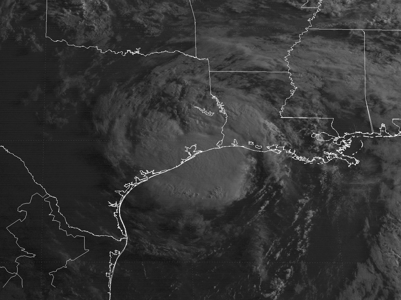
Above: GOES-7 visible satellite image of Hurricane Chantal at landfall along the Upper Texas coast at 7:31 AM CDT August 1, 1989.
The origin of Chantal can be traced back to a disturbance in the Intertropical Convergence zone near Trinidad on July 24th. The disturbance moved westward across the Caribbean the next few days with little development. By the afternoon of July 28th, a weak surface low was detected near Belize before moving inland across the Yucatán Peninsula. The low moved north northwest, emerging across the Southern Gulf early on July 30th. By daybreak, satellite imagery showed the low becoming much better organized. Ship reports confirmed the increased organization, and the first advisory on Tropical Depression #4 was issued at 2 PM CDT. Post storm analysis shows the depression likely formed at 7 AM CDT, which is indicated in the post storm track.
A mid to upper level trough over the Western Gulf and a mid to upper level ridge over the Bahamas steered Tropical Depression #4 to the north northwest over the Central Gulf, gradually becoming better organized for the remainder of the day through the early morning hours of July 31st. Reconnaissance aircraft confirmed the system increased in intensity overnight with a central pressure of 994 millibars (29.35 inches) and maximum sustained surface winds of 50 mph (45 mph) around 7:24 AM CDT, thus was upgraded to Tropical Storm Chantal. Post storm analysis shows the system likely attained tropical storm status shortly after midnight, but the National Hurricane Center wanted to confirm the intensity increase due to interpretation errors that sometimes occurred with the 7-kilometer resolution infrared GOES satellite imagery during the overnight hours.
A building mid to upper level ridge over the Central and Southeast United States began to steer Tropical Storm Chantal more to the northwest. The favorable upper level environment also helped Tropical Storm Chantal to strengthen rapidly for the remainder of the morning into the afternoon hours. An Air Force Reconnaissance aircraft confirmed the strengthening trend during the afternoon hours, with Chantal being upgraded to a minimum hurricane by 5 PM CDT.
Hurricane Chantal intensification trend leveled off as it headed northwest towards the Upper Texas coastline for the remainder of July 31st into the early morning hours of August 1st. Hurricane Chantal made landfall as a category one hurricane just east of High Island, TX around 7:30 AM CDT August 1st with maximum sustained winds of 80 mph (70 knots) and a minimum central pressure of 986 millibars (29.12 inches). A GOES-7 visible satellite image at 7:31 AM CDT August 1st shows Hurricane Chantal at landfall along the Upper Texas coast. Continuing northwest, Chantal was downgraded to a tropical storm just north of Houston, Texas by the early afternoon hours, and a tropical depression early on August 2nd near Waco, Texas. Chantal's surface circulation dissipated early on August 3rd across Southwest Oklahoma. Click here for an interactive track of Hurricane Chantal.
Thirteen U.S. deaths were attributed to Hurricane Chantal, all due to drownings. Ten people drowned in a capsized lift boat “Avco 5” about 25 miles south of Morgan City, Louisiana while heading for safety. Another man drowned about 100 miles south of New Orleans, Louisiana while attempting to leave an oil rig. Two teenage boys drowned in College Station, Texas when the raft they were riding in the flood waters overturned and were swept into a drainage pipe.
Minor tree damage with sporadic power outages from the tropical storm force winds occurred across Jefferson County and Western Cameron Parish. Across coastal Jefferson County Texas, storm surge and high wave action caused beach erosion and damaged Texas State Highway 87 between High Island and Sabine Pass, causing it to be closed. Beach erosion was noted across Cameron Parish in Southwest Louisiana causing damage to Louisiana Highway 82 between Johnsons Bayou and Holly Beach.
WIND & PRESSURE:
Hurricane force winds were confined over Galveston County and likely along coastal Western Jefferson County, although no observations were available near the eye landfall to confirm this. The highest peak gust of 82 mph (71 knots) was recorded in Galveston, TX. Tropical storm force winds occurred further north across Northeastern Jefferson and Orange Counties in Southeast Texas, as well as Western Coastal Cameron Parish in Southwest Louisiana. The strongest winds within our area occurred at Sea Rim State Park, Texas with a maximum sustained wind of 58 mph (50 knots) and a peak wind gust of 72 mph (63 knots) around 7 AM CDT August 1st near the time of landfall. Wind gusts of 30 to 40 mph were common across the remainder of Southeast Texas, Central and Southern Louisiana with the passing squalls. For complete meteorological statistics, see the Wind and Pressure section.
STORM SURGE:
Tides of 7.0 feet MSL were recorded at High Island, Texas, 4.0 feet MSL at Sabine Pass, Texas, and 4.2 feet MSL at Cameron, Louisiana. For other storm surge and high-water marks, see the Storm Surge section.
RAINFALL:
The rainfall pattern for Hurricane Chantal was most unusual, where most of the rainfall fell just west of the track. The highest storm total rainfall recorded across our region was 2.46 inches at Franklin, Louisiana. Many locations received less than an inch of rainfall, with a few locations missing the rainfall entirely. West of the track from Galveston to Houston, Texas was a different story, where rainfall ranged from 10 to 15 inches. The highest storm total rainfall of 20 inches was recorded at Friendswood, Texas. For complete rainfall totals reported across our region, see the Rainfall section.
TORNADOES:
Two F0 tornadoes occurred associated with Hurricane Chantal. The first occurred near Iota in Acadia Parish Louisiana around 6 AM CDT July 31st. The other occurred near Crystal Beach, Texas around 9:20 AM CDT August 1st. No deaths or injuries were reported, with only minimal property damage noted. For complete details on all the tornadoes reported across Texas and Louisiana, see the Tornadoes section.
|


