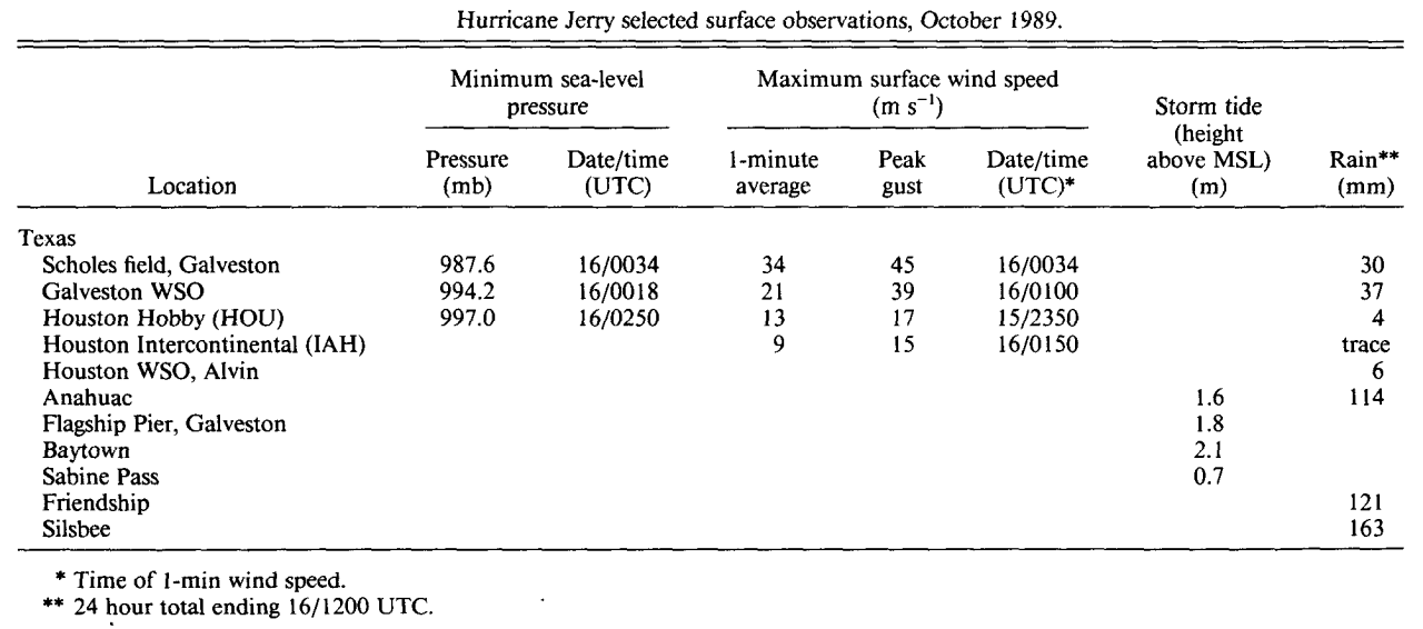
Wind and Pressure Reports
Sources: National Weather Service Post Storm Reports
National Centers for Environmental Information (NECI)
Monthly Weather Review - 1989 Atlantic Hurricane Season
Monthly Weather Review Meteorological Data of Hurricane Jerry (Note: All data in metric system) |
| Location |
Minimal Sea Level Pressure |
Maximum Sustained Wind (1 Min. Avg.) |
Peak Wind Gust |
Lafayette, LA
(KLFT-WBAN) |
1010.8 mb (29.85")
10/15 @ 4:00 PM CDT |
16 mph (14 knots)
10/15 @ 2:00 PM CDT |
23 mph (20 knots)
10/16 @ 3:00 AM CDT |
Lake Charles, LA
(KLCH-NWS) |
1009.4 mb (29.81")
10/15 @ 7:50 PM CDT |
20 mph (17 knots)
10/15 @ 2:50 PM CDT |
32 mph (28 knots)
10/15 @ 12:17 PM CDT |
| Cameron, LA |
1008.5 mb (29.78")
10/15 @ 3:20 PM CDT |
|
|
Alexandria (Esler), LA
(KESF-WBAN) |
1010.2 mb (29.83")
10/15 @ 6:00 PM CDT |
17 mph (15 knots)
10/16 @ 12:00 PM CDT |
25 mph (22 knots)
10/16 @ 12:00 PM CDT |
Fort Polk, LA
(KPOE-Army Base) |
1009.8 mb (29.82")
10/15 @ 5:00 PM CDT |
15 mph (13 knots)
10/15 @ 11:00 PM CDT |
23 mph (20 knots)
10/15 @ 11:00 PM CDT |
Port Arthur, TX
(KBPT-NWS) |
1006.6 mb (29.72")
10/15 @ 6:35 PM CDT |
28 mph (24 knots)
10/16 @ 12:59 AM CDT |
36 mph (31 knots)
10/16 @ 12:23 AM CDT |
Sea Rim State Park, TX
(SRST2-NDBC) |
1007.0 mb (29.74")
10/15 @ 7:00 PM CDT |
(*) 36 mph (31 knots)
10/15 @ 11:10 PM CDT |
44 mph (38 knots)
10/15 @ 11:20 PM CDT |
Galveston, TX
(KGLS-WBAN) |
987.6 mb (29.16")
10/15 @ 7:34 PM CDT |
75 mph (65 knots)
10/15 @ 7:36 PM CDT |
100 mph (87 knots)
10/15 @ 7:34 PM CDT |
Galveston, TX
(NWS) |
994.2 mb (29.36")
10/15 @ 7:18 PM CDT |
46 mph (40 knots)
10/15 @ 8:00 PM CDT |
85 mph (74 knots)
10/15 @ 7:54 PM CDT |
Ellington AFB
(KEFD) |
995.3 mb (29.39")
10/15 @ 9:53 PM CDT |
37 mph (32 knots)
10/15 @ 9:53 PM CDT |
52 mph (45 knots)
10/15 @ 9:53 PM CDT |
Houston (Hobby), TX
(KHOU-WBAN) |
997.0 mb (29.44")
10/15 @ 9:50 PM CDT |
29 mph (25 knots)
10/15 @ 6:50 PM CDT |
37 mph (32 knots)
10/15 @ 5:50 PM CDT |
Houston (Intrnl.), TX
(KIAH-WBAN) |
998.0 mb (29.47")
10/15 @ 9:58 PM CDT |
21 mph (18 knots)
10/15 @ 8:50 PM CDT |
33 mph (29 knots)
10/15 @ 10:10 PM CDT |
(E)=Estimated
(I) =Incomplete
(*) = Maximum Sustained Wind (2 Min. Avg.) |


