|
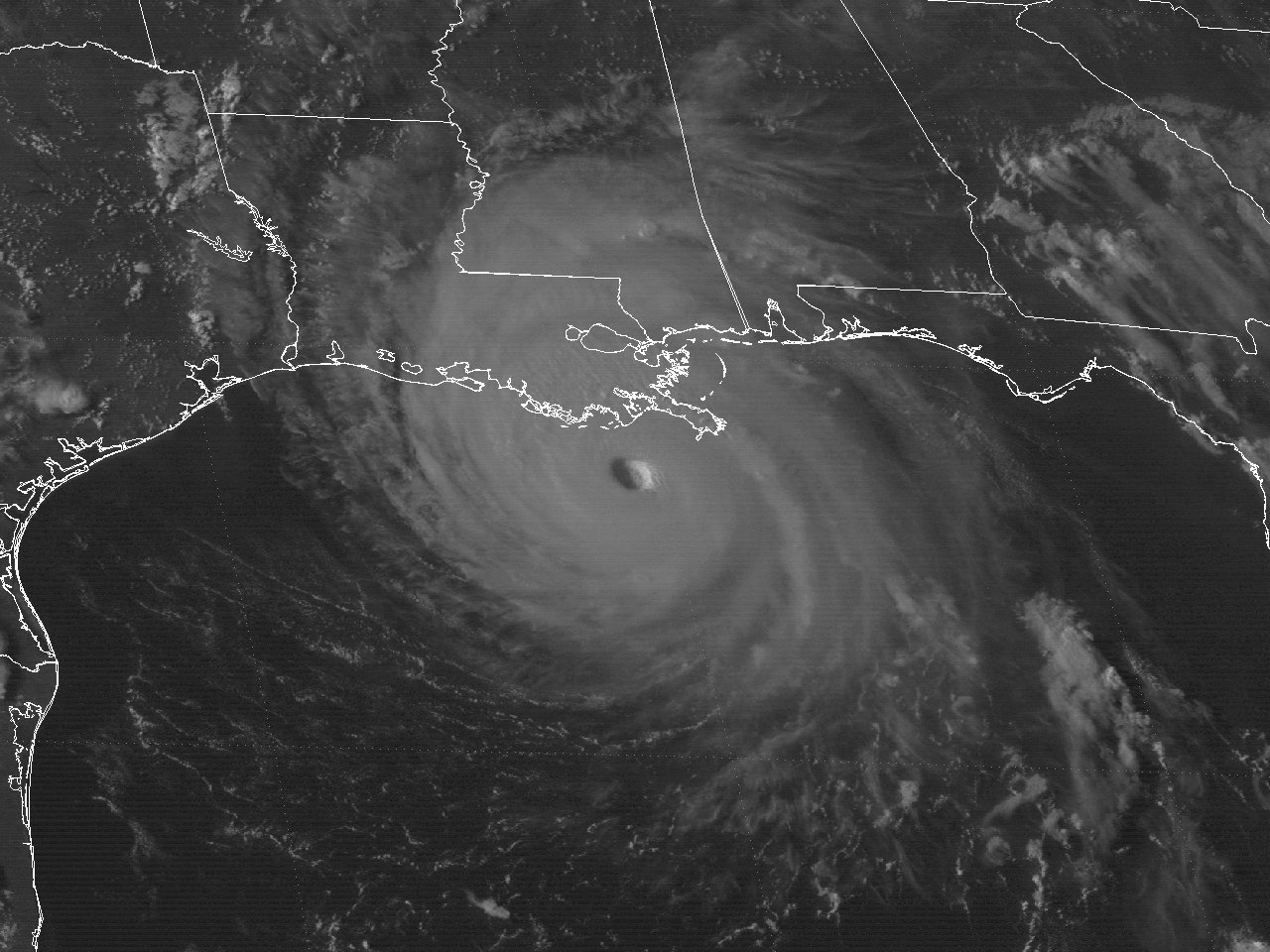
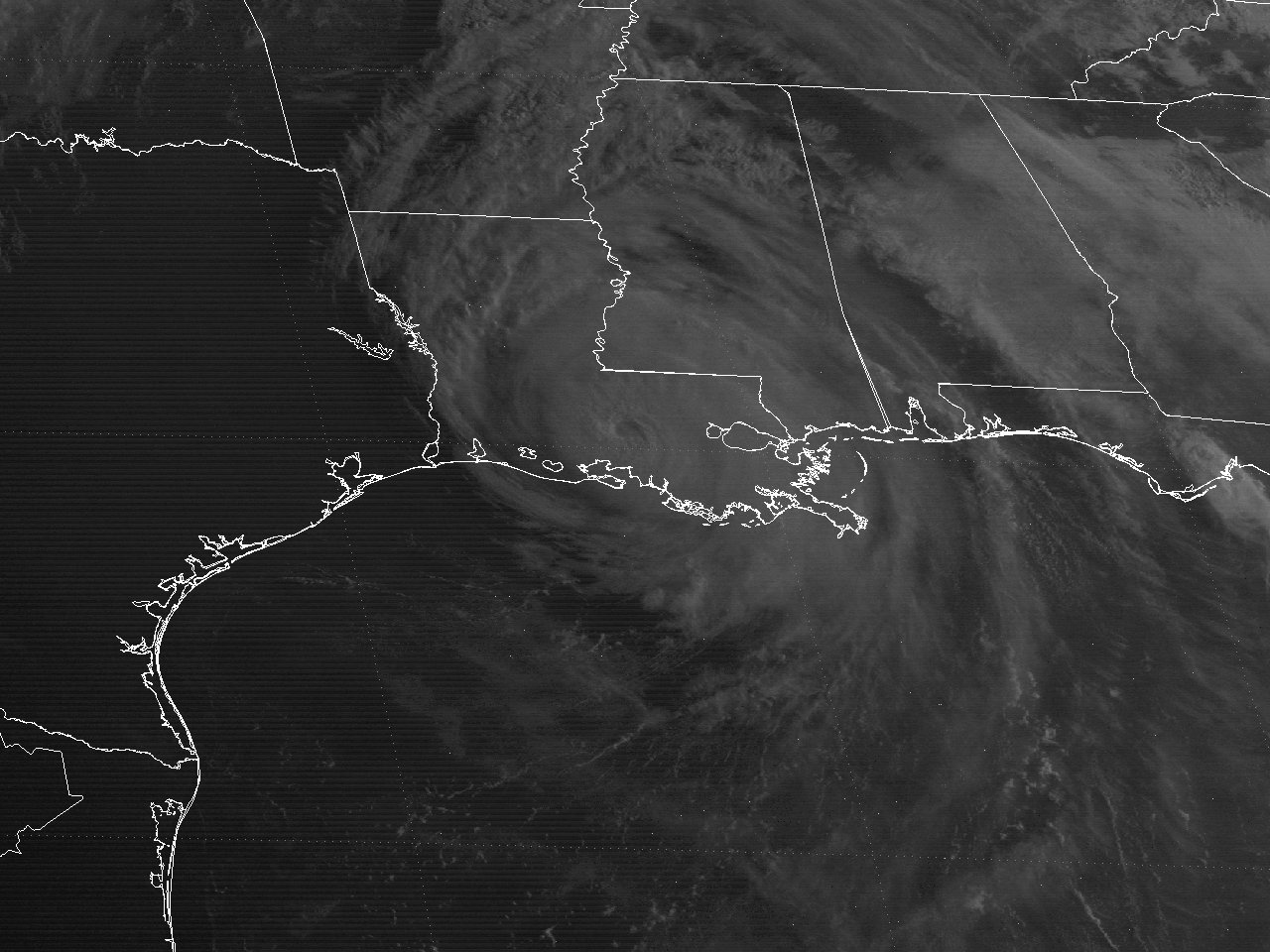
Above: GOES 7 Visible Satellite Image of Hurricane Andrew south of Grand Isle, LA at 2231 UTC (5:31 PM CDT) on August 25, 1992.
Andrew's journey began as a tropical wave departing the West African coast on August 14th. By August 16th, the wave was organized enough to be classified a tropical depression, and then a tropical storm on the 17th. Andrew tracked west to northwest across the Atlantic around the south side of a ridge of high pressure. An upper low near Bermuda initially kept Tropical Storm Andrew from developing stronger as convection around the storm was sheared away from the low-level center. Eventually, the upper low weakened and retreated north while a deep ridge of high pressure over the southeastern U.S. strengthened and turned the system back to the west.
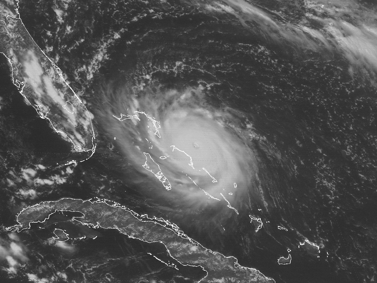
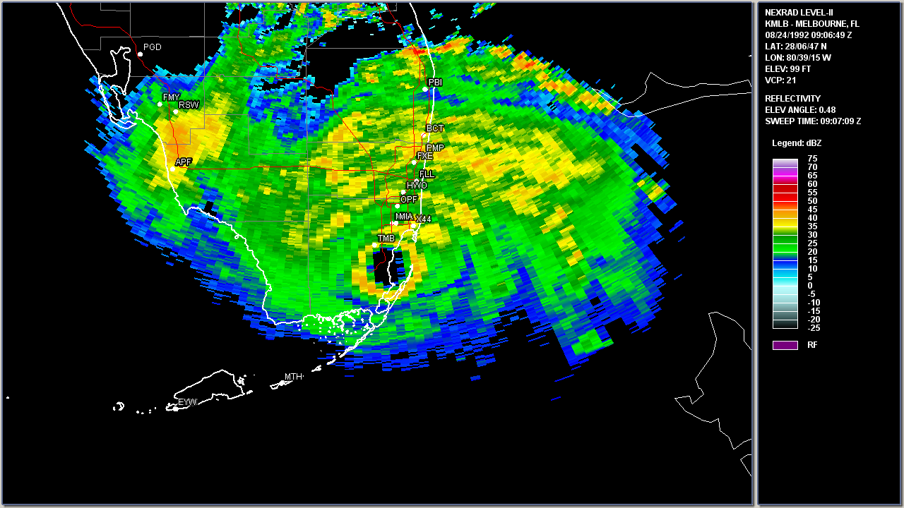
With the upper-level ridge of high pressure firmly established across the Eastern United States and Western Atlantic, Andrew reached minimal hurricane intensity early on the 22nd and began to accelerate westward. During the next 36 hours, Andrew explosively intensified from a category one to a category five hurricane by mid-day on the 23rd. During this period, the central pressure dropped 72 millibars, allowing the storm to reach its maximum intensity of 175 mph (150 knots) with a minimum central pressure of 922 mb (27.23 inches). The ridge held steady over the next couple of days, driving the small but very intense hurricane west. Andrew weakened slightly to a category four hurricane while crossing the Bahamas, but re-intensified to a category five while crossing the Gulf Stream east of the Florida peninsula. The storm slammed Dade County, Florida (south of downtown Miami, near Homestead) around 5 AM EDT on August 24th with winds of 165 mph (145 knots) and a minimum central pressure of 922 millibars (27.23 inches). The Miami, FL WSR-57 radar (located on the roof of the National Hurricane Center) was destroyed shortly after the last complete scan of Hurricane Andrew at landfall. The newly installed Melbourne, FL WSR-88D captured Andrew's landfall and trek across South Florida.
Andrew weakened slightly to a category four while traversing South Florida for a few hours, eventually emerging over the Gulf. For the remainder of the 24th, Andrew continued to move quickly west-northwestward with little change in strength. By the late morning hours of the 25th, an eyewall replacement cycle completed, with a much larger eye emerging on visible satellite imagery as Andrew slowly strengthened once again. Andrew reached 145 mph (125 knots) and a minimum central pressure of 937 millibars (27.67 inches) during the late afternoon and early evening hours of the 25th, about 50 miles south of the Southeast Louisiana coast. Andrew began to slow down and move northwest for the remainder of the 25th as an approaching upper-level trough began eroding the western side of the ridge.
Hurricane Andrew continued to weaken during the early morning hours of August 26th as the eye paralleled just offshore the South-Central Louisiana coast. Andrew finally made landfall near Point Chevreuil (about 20 miles west-southwest of Morgan City) at 3:30 AM CDT as a category 3 hurricane with winds of 115 mph (100 knots) and a central pressure of 956 millibars (28.23 inches). The newly installed Houston, TX WSR-88D captured Andrew's landfall across South Central Louisiana. See the Radar and Satellite Animation Imagery section for the animation sequences of Andrew
After landfall, Andrew continued on a more northerly track while weakening across South-Central Louisiana, traversing most of the Atchafalaya Basin. Andrew was downgraded to a tropical storm by noontime, northwest of Baton Rouge, Louisiana. The storm was further downgraded to a tropical depression by midnight on the 27th, just southwest of Jackson, Mississippi. Click here for an interactive track of Hurricane Andrew.
Power outages and damage to homes and businesses across South Central Louisiana, especially across St. Mary, Iberia, and St. Martin parishes was extensive. Damage to crops, especially to sugarcane, was extensive. The combination of the high winds defoliating most of the trees, as well as the churned up bottom water, caused oxygen depletion and massive fish kills across the Atchafalaya Basin. Further inland across Lafayette, Acadia, and St. Landry parishes, power outages were common due to powerlines and poles downed, with extensive tree limb breakage and some trees uprooted. Signs and billboards were damaged or toppled, along with some damage to roofs, mobile homes, and lighter structures. In Lafayette parish, one death was attributed to traffic accident with no power to traffic lights, and 62 other injuries noted across the parish.
Hurricane Andrew caused 7 deaths and an estimated $1 billion in damages in Louisiana. Combining this with Florida, Andrew directly caused 26 deaths in the U.S. and indirectly caused 39 more, with $27.3 billion in total damages. For more detailed information on the damages across Florida and Louisiana, see the Storm Data Excerpt for Hurricane Andrew.
WIND & PRESSURE:
The strongest winds were recorded across Iberia, St. Mary and St. Martin Parishes. The Berwick, Louisiana Fire Station recorded maximum sustained winds of 95 mph (83 knots) with a peak gust of 120 mph (104 knots) at 3:05 AM CDT August 26th using an anemometer at 60 feet above the ground. Morgan City, Louisiana recorded maximum sustained winds of 92 mph (80 knots) with a peak gust of 108 mph (94 knots) at 3:05 AM CDT August 26th using an anemometer at 45 feet above the ground. Jeanerette, Louisiana recorded a maximum sustained wind of 77 mph (67 knots) with a peak gust of 86 mph (75 knots), along with a minimum sea level pressure of 975.0 mb (28.79 inches) at 3:45 AM CDT August 26th. At Salt Point, Louisiana near the point of landfall, the last AMOS observation (due to power outage and likely instrument failure) recorded a wind gust of 83 mph (72 knots) at 2:28 AM CDT August 26th. Further inland, Lafayette, Louisiana recorded a maximum sustained wind of 54 mph (47 knots) and a peak wind gust of 71 mph (62 knots), along with a minimum sea level pressure of 990.5 millibars (29.25 inches) between 6-7 AM CDT August 26th. A higher gust of 104 mph (90 knots) was recorded at the Lafayette Courthouse, but the anemometer was located above the roof of this several story building. For complete meteorological statistics, see the Wind and Pressure section.
STORM SURGE:
The highest storm surge values of 5 to 8 feet MSL were mainly observed from Cypremort Point, LA and points east across eastern St. Mary Parish where the eye made landfall. Further west, tides were below astronomical level due to the strong northerly winds pushing the water south into the Gulf. For other storm surge and high-water marks across our region, see the Storm Surge section.
RAINFALL:
The highest rainfall total in Louisiana occurred at Hammond with 11.92 inches. For our region west of the Atchafalaya River, rainfall of 5 to 9 inches occurred across South Central Louisiana along and east of the path of Andrew, with the highest total of 9.31 inches occurring at Morgan City, Louisiana. For complete rainfall totals reported across our region, see the Rainfall section.
TORNADOES:
Several tornadoes occurred ahead and during Andrew’s landfall, most of them east of the Atchafalaya River across Southeast Louisiana and the rest across Northeast Louisiana. The strongest tornado occurred from Reserve to LaPlace, Louisiana between 8:10-8:20 PM CDT August 25th. This tornado was rated an F3, killed 2 people, injured 32 others, and caused 25 million in damages. Other F0-F1 tornadoes were recorded across Iberville, St. Tammany, Point Coupee, Tangipahoa, Franklin, Union, and Madison parishes. For complete details on all the tornadoes reported, see the Tornadoes section.
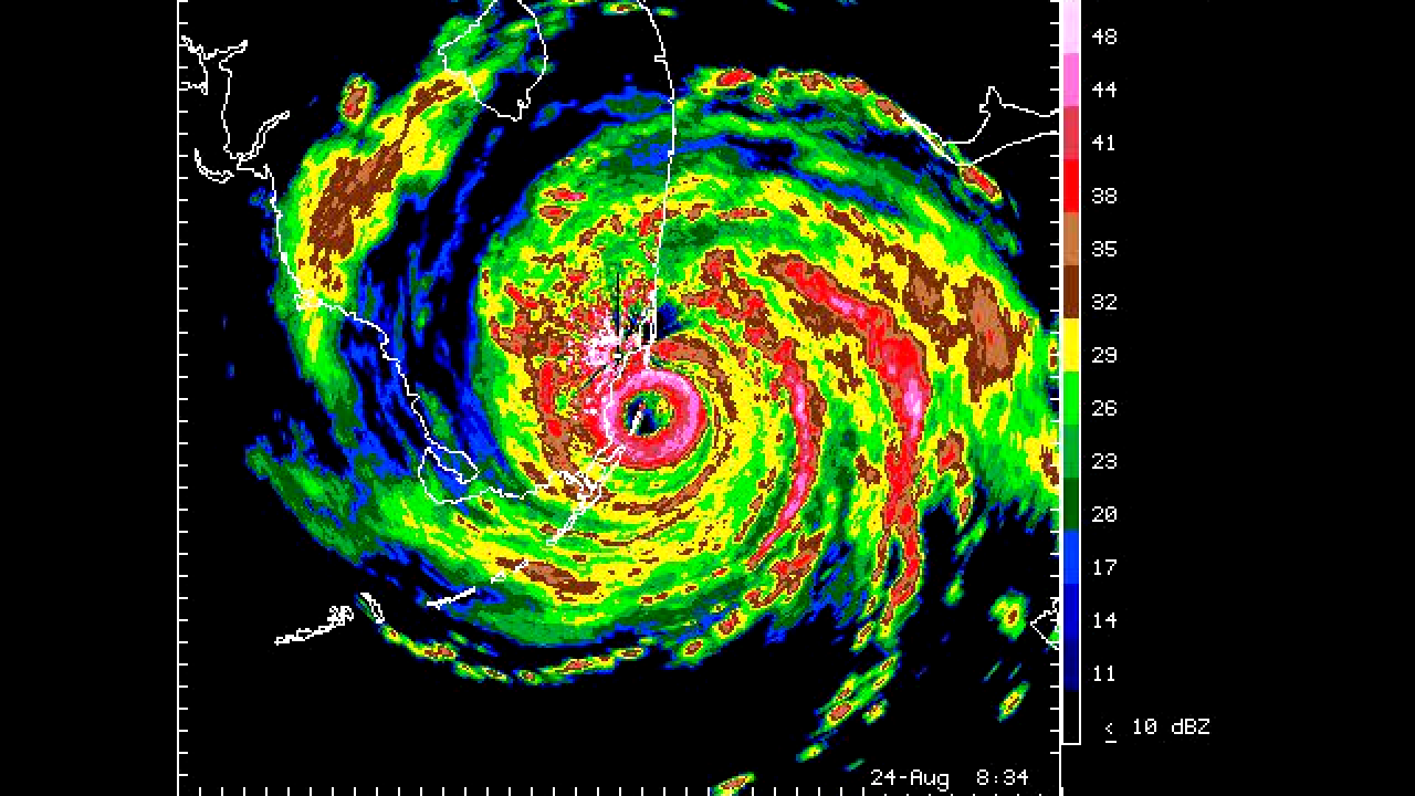
Above: Miami, FL WSR-57 last radar image of Hurricane Andrew shortly before landfall near Homestead, FL at 4:34 AM EDT on August 24, 1992.
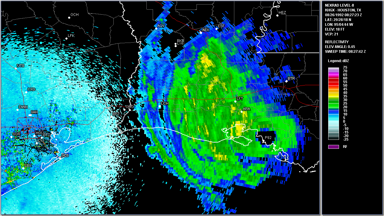
Above: Houston, TX WSR-88D radar image of Hurricane Andrew making landfall near Point Chevreuil, LA at 3:27 AM CDT on August 26, 1992.
| Other Post Storm Reports |
| Monthly Weather Review - 1992 Atlantic Hurricane Season |
| National Hurricane Center Hurricane Andrew Storm Wallet of Documents |
| National Hurricane Center |
Hurricane Research Division |
Storm Data |
| Miami, FL |
Key West, FL |
West Palm Beach, FL |
| Tampa Bay, FL |
Melbourne, FL |
Mobile, AL |
| New Orleans, LA |
Baton Rouge, LA |
Lake Charles, LA |
| |
Port Arthur, TX |
|
Original webpage design and content for 20th Anniversary: Donovan Landreneau, Andy Tingler, Lance Escudé, Jonathan Brazzell, Donald Jones
Updated webpage design and content for 30th Anniversary: Donovan Landreneau
|


