Wind and Pressure Reports
Sources: National Weather Service Post Storm Reports
National Centers for Environmental Information (NECI)
Monthly Weather Review - 1993 Atlantic Hurricane Season
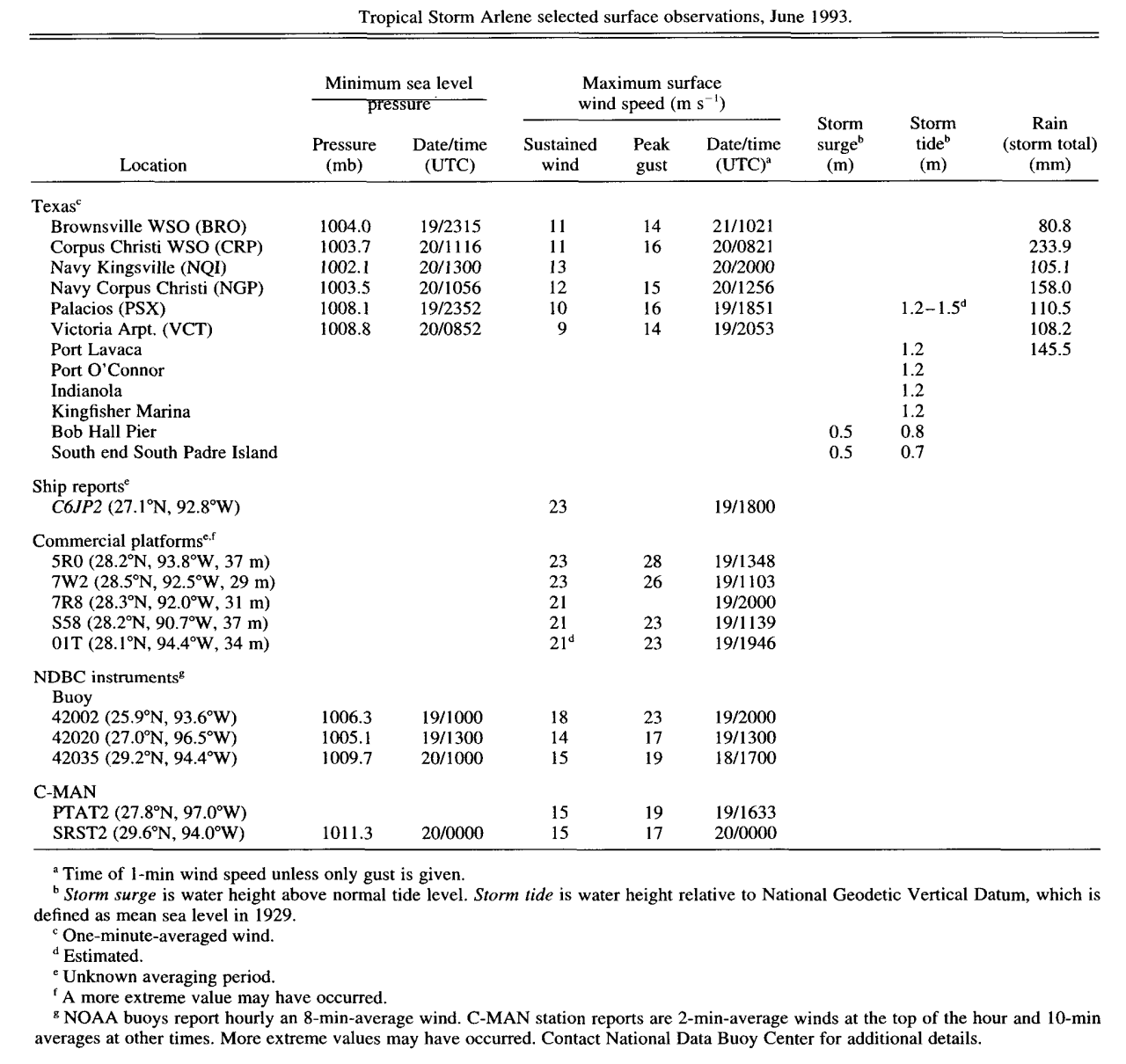
Monthly Weather Review Meteorological Data of Tropical Storm Arlene (Note: All data in metric system) |
| Location |
Minimal Sea Level Pressure |
Maximum Sustained Wind (1 Min. Avg.) |
Peak Wind Gust |
Lafayette, LA
(KLFT-WBAN) |
1014.9 mb (29.97")
6/20 @ 5:00 AM CDT |
23 mph (20 knots)
6/20 @ 12:00 PM CDT |
29 mph (25 knots)
6/20 @ 12:00 PM CDT |
Lake Charles, LA
(KLCH-NWS) |
1013.8 mb (29.94")
6/19 @ 7:00 PM CDT |
24 mph (21 knots)
6/20 @ 10:06 AM CDT |
32 mph (28 knots)
6/20 @ 10:06 AM CDT |
Alexandria (Esler), LA
(KESF-WBAN) |
1015.9 mb (30.00")
6/20 @ 7:00 AM CDT |
20 mph (17 knots)
6/20 @ 2:00 PM CDT |
31 mph (27 knots)
6/20 @ 2:00 PM CDT |
Fort Polk, LA
(KPOE-Army Base) |
1014.2 mb (29.95")
6/20 @ 6:00 AM CDT |
17 mph (15 knots)
6/20 @ 12:12 PM CDT |
34 mph (30 knots)
6/20 @ 12:12 PM CDT |
Beaumont, TX
(KBPT-NWS) |
1011.9 mb (29.88")
6/19 @ 7:00 PM CDT |
25 mph (22 knots)
6/20 @ 7:38 AM CDT |
37 mph (32 knots)
6/20 @ 7:38 AM CDT |
Sea Rim State Park, TX
(SRST2-NDBC) |
1011.3 mb (29.86")
6/19 @ 7:00 PM CDT |
(*) 33 mph (29 knots)
6/19 @ 7:00 PM CDT |
38 mph (33 knots)
6/19 @ 7:00 PM CDT |
Galveston, TX
(KGLS-WBAN) |
1010.2 mb (29.83")
6/19 @ 7:00 PM CDT |
23 mph (20 knots)
6/20 @ 9:00 AM CDT |
32 mph (28 knots)
6/19 @ 6:07 AM CDT |
Palacios, TX
(KPSX-WBAN) |
1008.1 mb (29.77")
6/19 @ 6:52 PM CDT |
23 mph (20 knots)
6/19 @ 12:51 PM CDT |
36 mph (31 knots)
6/19 @ 12:51 PM CDT |
Victoria, TX
(KVCT-NWS) |
1008.8 mb (29.64")
6/20 @ 3:52 AM CDT |
21 mph (18 knots)
6/19 @ 3:53 PM CDT |
31 mph (27 knots)
6/19 @ 3:53 PM CDT |
Corpus Christi, TX
(KCRP-NWS) |
1003.7 mb (29.64")
6/20 @ 6:15 AM CDT |
25 mph (22 knots)
6/20 @ 3:21 AM CDT |
37 mph (32 knots)
6/20 @ 3:21 AM CDT |
Corpus Christi, TX
(KNGP-NAS) |
1003.5 mb (29.63")
6/20 @ 5:56 AM CDT |
26 mph (23 knots)
6/20 @ 5:56 AM CDT |
35 mph (30 knots)
6/20 @ 5:56 AM CDT |
Kingsville, TX
(KNQI-NAS) |
1002.1 mb (29.59")
6/20 @ 8:00 AM CDT |
29 mph (25 knots)
6/20 @ 3:00 PM CDT |
|
Brownsville, TX
(KBRO-NWS) |
1004.0 mb (29.65")
6/19 @ 6:15 PM CDT |
25 mph (22 knots)
6/21 @ 5:21 AM CDT |
32 mph (28 knots)
6/21 @ 5:21 AM CDT |
(E)=Estimated
(I) =Incomplete
(*) = Maximum Sustained Wind (2 Min. Avg.) |


