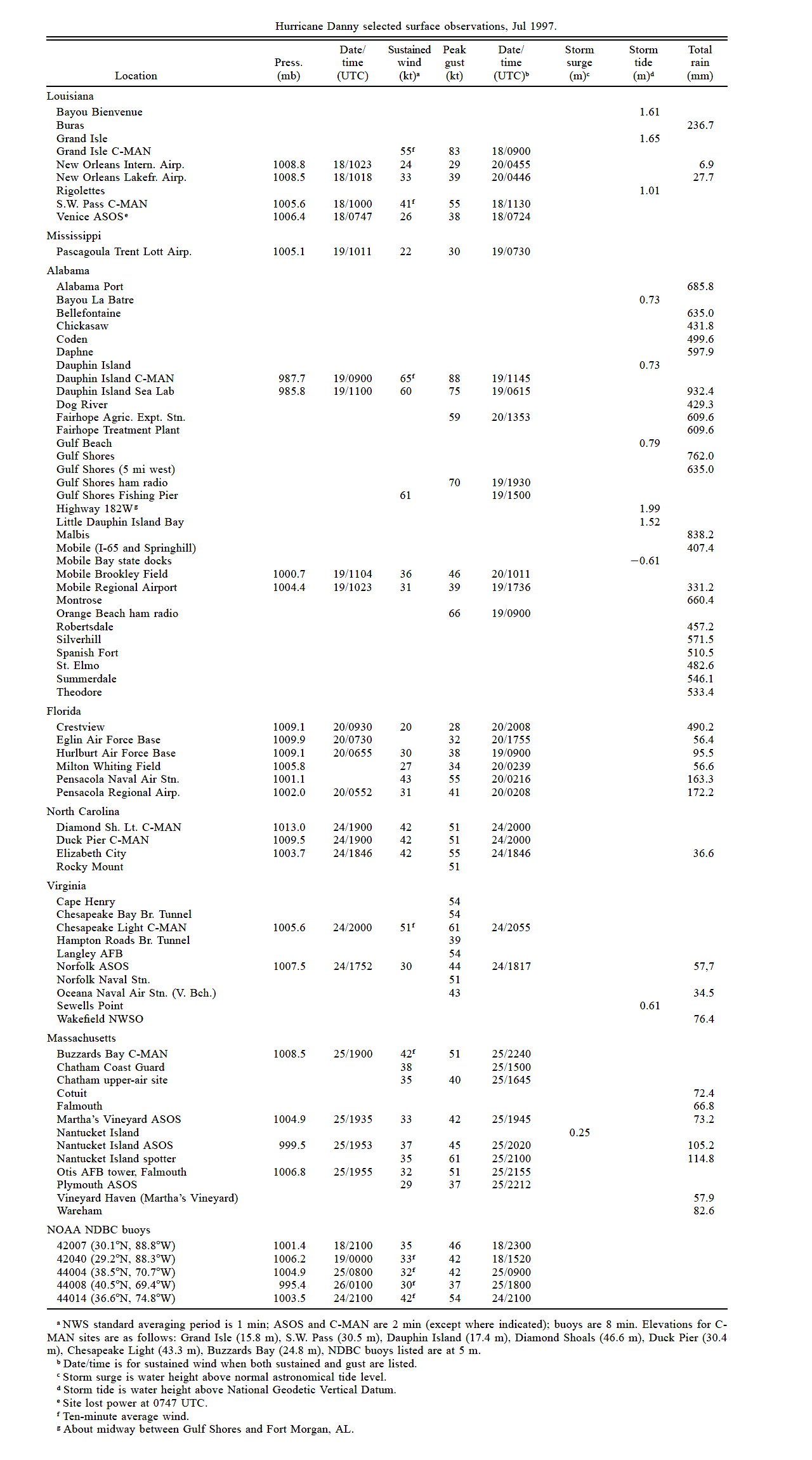
Wind and Pressure Reports
Sources: National Weather Service Post Storm Reports
National Centers for Environmental Information (NECI)
Monthly Weather Review - 1997 Atlantic Hurricane Season |
| Location |
Minimal Sea Level Pressure |
Maximum Sustained Wind (2 Min. Avg.) |
Peak Wind Gust |
Port Arthur, TX
(KBPT) |
1010.5 mb (29.84")
7/18 @ 5:53 PM CDT |
13 mph (11 knots)
7/18 @ 9:14 PM CDT |
|
New Iberia, LA
(KARA) |
1010.8 mb (29.85")
7/18 @ 6:33 PM CDT |
14 mph (12 knots)
7/17 @ 4:23 PM CDT |
17 mph (15 knots)
7/17 @ 3:30 PM CDT |
Lafayette, LA
(KLFT) |
1010.8 mb (29.85")
7/18 @ 6:30 PM CDT |
22 mph (19 knots)
7/16 @ 4:58 PM CDT |
26 mph (23 knots)
7/16 @ 4:57 PM CDT |
Lake Charles, LA
(KLCH) |
1011.2 mb (29.86")
7/18 @ 6:19 PM CDT |
16 mph (14 knots)
7/19 @ 2:35 PM CDT |
21 mph (18 knots)
7/19 @ 2:34 PM CDT |
Alexandria (Esler), LA
(KESF) |
1010.8 mb (29.85")
7/18 @ 6:53 PM CDT |
9 mph (8 knots)
7/17 @ 5:53 PM CDT |
|
Fort Polk, LA
(KPOE) |
1011.2 mb (29.86")
7/18 @ 6:00 PM CDT |
11 mph (10 knots)
7/16 @ 7:00 PM CDT |
17 mph (15 knots)
7/16 @ 7:00 PM CDT |
New Orleans, LA
International
(KMSY) |
1008.8 mb (29.79")
7/18 @ 5:23 AM CDT |
28 mph (24 knots)
7/19 @ 11:55 PM CDT |
33 mph (29 knots)
7/19 @ 11:55 PM CDT |
New Orleans, LA
Lakefront
(KNEW) |
1008.5 mb (29.78")
7/18 @ 5:18 AM CDT |
38 mph (33 knots)
7/19 @ 11:46 PM CDT |
45 mph (39 knots)
7/19 @ 11:46 PM CDT |
Belle Chase NAS, LA
(KNBG) |
1006.8 mb (29.73")
7/18 @ 4:00 AM CDT |
22 mph (19 knots)
7/18 @ 4:00 AM CDT |
31 mph (27 knots)
7/18 @ 4:33 AM CDT |
Grand Isle, LA
(GDIL1)
(Anemometer 52 feet) |
991.5 mb (29.28")
7/18 @ 3:00 AM CDT |
(*) 63 mph (55 knots)
7/18 @ 3:00 AM CDT |
95 mph (83 knots)
7/18 @ 3:00 AM CDT |
Biloxi Keesler AFB, MS
(KBIX) |
1008.5 mb (29.78")
7/18 @ 5:00 PM CDT |
19 mph (17 knots)
7/18 @ 6:00 PM CDT |
29 mph (25 knots)
7/18 @ 11:20 AM CDT |
Pascagoula, MS
(KPQL) |
1005.1 mb (29.68")
7/19 @ 5:11 AM CDT |
25 mph (22 knots)
7/19 @ 2:30 AM CDT |
35 mph (30 knots)
7/19 @ 2:30 AM CDT |
(E) = Estimated
(I) = Incomplete
(*) = Maximum Sustained Wind (10 Min. Avg.) |